This article originally appeared in the Los Angeles Times on April 10.
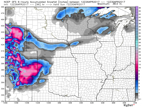
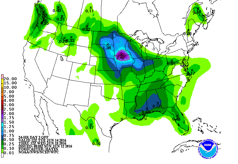
A potentially record-breaking storm is squeezing the warmth from spring as it brings snow and howling winds across the U.S. Great Plains and threatens to flood rivers from Canada to the Gulf of Mexico.
The giant system, set to strengthen Wednesday, has sparked blizzard warnings from Colorado to Minnesota and could drop more than 2 feet of snow in South Dakota and as much as 8 inches in Minneapolis, the National Weather Service said. Severe thunderstorms will hit Texas and the Mississippi Valley. The system threatens to delay wheat and corn planting.
“It is pretty extensive,” David Roth, a senior branch forecaster at the U.S. Weather Prediction Center, said by telephone.
The storm, which will pack near-record low pressure, could be on par with the massive system that triggered flooding across Nebraska and Iowa last month. Snow and rain area already falling across the Great Plains and Midwest. The storm will build over Wyoming on Wednesday, cross Nebraska on Thursday and then hit Minneapolis, said Rob Carolan, owner of Hometown Forecast Services.
Farther south, the storm will push dry winds across Kansas, Oklahoma, New Mexico and Texas — raising the risk of wildfires.
The Mississippi River is already at moderate-to-major flood stage in Wisconsin, Illinois and Iowa. The Red River is at major flood stage in Fargo, N.D.
“Because the Mississippi is flooding — none of this is welcome,” Roth said.
Nonetheless, the Mississippi should be able to handle this week’s storm, because water levels are currently falling, said Matt Roe, spokesman for the Army Corps of Engineers in New Orleans. The Corps has begun to close the Bonnet Carre spillway upstream from New Orleans, designed to prevent flooding.
High water has restricted Mississippi barge traffic to daylight and has limited the amount of freight that can be hauled, said Austin Golding, president of Golding Barge Line in Vicksburg, Miss. Right now, the river is entirely navigable, but the hardest parts to traverse are the bridges in Vicksburg and Baton Rouge.
“May will be nasty if it gets hot up north and the snow melt accelerates after this winter system they are encountering now,” Golding said.
This system’s icy reach won’t extend to Chicago, which will get rain and have a low of 39 degrees Wednesday before temperatures rebound into the 60s by Thursday. Detroit and Toronto will also be spared, Carolan said.
As the storm passes, weather will whiplash between extremes in many places. On Tuesday, Denver’s temperature reached 78 degrees. Wednesday, however, the city is under a blizzard warning with readings set to plunge to 21, the weather service said. Cheyenne, Wyo., will go from 71 on Tuesday to 18 degrees late Wednesday.
While the storm bulldozes across the central U.S., mild air on the East Coast will keep temperatures in New York in the high 50s and low 60s through the rest of the week, the weather service said.
The snow and rain across the northern Midwest will delay corn and wheat planting, said Dan Hicks, a meteorologist with Freese-Notis Weather Services in Des Moines, Iowa. Farther south, from Kansas to Southern Illinois, planting is unlikely to be interrupted.
For the third year in a row, the “M” storm in the Atlantic is prepared to wreak havoc on a populated area, but Michael isn’t the only headline maker in the weather at the moment.
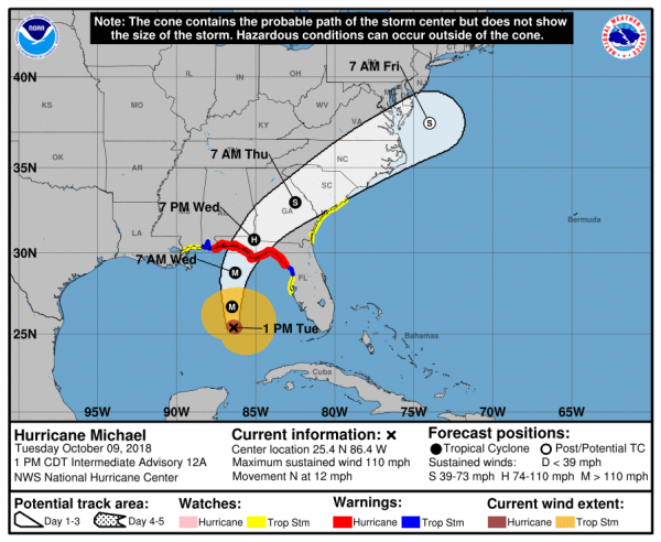
Hurricane Michael isn’t the only storm in the news, but it is the biggest threat at the moment. As of early Tuesday afternoon, Michael was centered about 335 miles south of Panama City, Florida, moving toward the north at 12 mph. Maximum sustained winds are near 110 mph, making Michael a Category 2 Hurricane. Additional strengthening is expected over the next 12-18 hours as the storm moves over the warm waters of the eastern Gulf of Mexico. Hurricane and Storm Surge Warnings are in effect for the Florida Panhandle and the Big Bend area of Florida, with Tropical Storm Warnings and Watches surrounding the Hurricane Warnings. Tropical Storm Watches are also in effect for the Atlantic coast from northeastern Florida into South Carolina.
Forecast track for Hurricane Michael. Image provided by the National Hurricane Center.
Michael is expected to make landfall in the Florida Panhandle Wednesday afternoon, likely as a Category 3 storm. Strong winds, torrential rainfall, storm surge, and some tornadoes are all possible with this storm. Unlike Florence, which hung around the Carolinas for days and dumped incredible amounts of rainfall on the region, Michael is expected to keep moving at a steady pace, emerging off the Mid-Atlantic coast by Friday morning. Rainfall totals of 5-10 inches are still expected in parts of the region, which will produce flooding in some areas, especially in Carolinas, where many areas are still recovering from Florence. Right along the coast, a storm surge of 6-12 feet is possible, especially in the Big Bend area of Florida. Fortunately, this area is not heavily populated, but for the residents that do live in this area, storm surge flooding is a significant threat.
This is the 3rd year in a row that the “M” storm is expected to result in significant damage to a populated area. In 2014, Category 5 Hurricane Matthew left a path of death and destruction across parts of Haiti, Cuba, the Bahamas, and eventually parts of the southeastern United States. Last year, Category 5 Hurricane Maria devastated the northeastern Caribbean, including Puerto Rico and the US Virgin Islands. While Michael is not expected to become a Category 5 storm, it is still expected to result in significant damage to parts of Florida and the Southeast.
Satellite loop of Tropical Storm Leslie. Loop provided by NOAA.
Meanwhile, in the eastern Atlantic, Tropical Storm Leslie refuses to go away. As of midday Tuesday, Leslie was centered a little more than 1000 miles west-southwest of the Azores, moving toward the south-southeast at 13 mph. Maximum sustained winds are near 65 mph. The forecast for Leslie calls for a turn more toward the east over the next few days while it strengthens back into a hurricane. Leslie is expected to remain over open waters for the next few days, and could become an extratropical storm this weekend while continuing on a general easterly track.
To the south, Tropical Storm Nadine as formed nearly 500 miles southwest of the Cabo Verde Islands. Nadine has maximum sustained winds near 40 mph, and is moving toward the west-northwest at 9 mph. Nadine is expected to remain fairly weak over open waters for the next several days while turning more toward the northwest. As it moves over colder water late this week and this weekend, it should weaken and eventually dissipate.
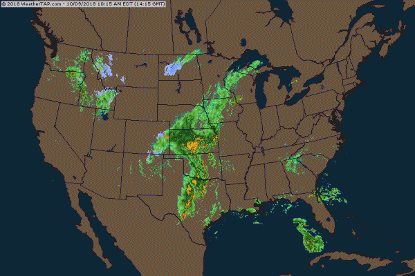
Back in the United States, unseasonably warm conditions remain in place across much of the eastern half of the nation. Temperatures are in the 70s and 80s across much of the region, which is 15 to 25 degrees above normal. A strong frontal system is located in the Plains states this afternoon, separating the warm air in the East, from much cooler weather behind it in the Plains and the Rockies. Right along this front, which hasn’t moved much for the past 24 hours, severe weather and heavy rainfall are common this afternoon.
National radar loop from early Tuesday afternoon. Loop provided by Weathertap.
Several tornadoes have been reported already today, including a few in the Oklahoma City area, and more are expected later today and tonight. Heavy rainfall is also expected from Texas into the Central Plains and parts of the Upper Midwest. Rainfall totals of 1-3 inches and locally heavier may produce flash flooding in some areas. Flash flood watches are in effect for much of the region.
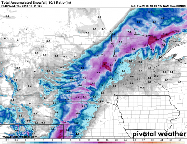
Snowfall forecast through Thursday morning from the WRF model. Image provided by Pivotal Weather.
On the other side of the front, where much cooler weather is in place, rain is expected to change over to snow as low pressure rides along the front and into the Midwest. Winter weather advisories have already been posted for parts of the region. Snow is already falling in parts of Colorado this afternoon, and several inches may fall over the next 36-48 hours from western portions of Kansas and Nebraska into the Dakotas and northern Minnesota.
The “Dog Days of Summer” have arrived, with heat and humidity across a large part of the nation. Meanwhile, severe weather is possible across the Midwest on Friday.
A weather pattern that is both typical and atypical of summer at the same time is going to settle into the nation over the next several days. The typical part is that we’ll have a ridge of high pressure off the East Coast, and another one in the Southwest. The ridge off the East Coast will result in heat and humidity up and down the coastline for the next several days. The ridge in the Southwest will bring very hot conditions to the Southwest and especially the Southern Plains, where record highs are expected over the next several days. The Atypical part is across the Midwest. Normally, in between the two ridges of high pressure you’d have a trough of low pressure, but in this case, we actually have a closed upper-level low pressure system. While these are common in the fall, winter, and spring, they usually don’t occur much in the summer. This will bring cooler than normal conditions into the Midwest for the next few days.
The upper-level pattern features ridges of high pressure in the Southwest and off the East Coast, and an upper-level low pressure system in the Great Lakes. Image provided by Pivotal Weather.
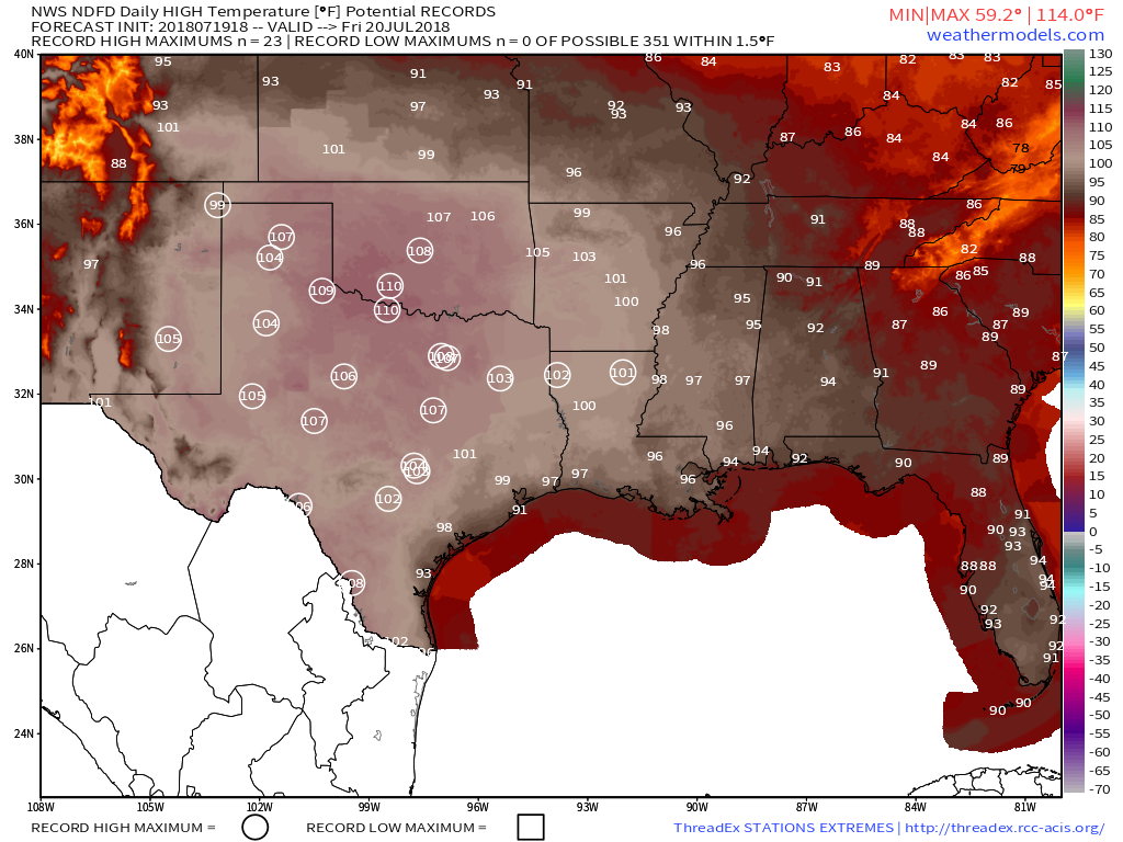
While hot weather is expected across Texas and the Southwest during the summer, the ridge of high pressure that is currently setting up across the region will bring in temperatures that are well above normal. In fact, record highs are expected for the next several days across much of Texas, as temperatures soar past 100 across much of the state, with some locations possibly exceeding 110 degrees. The heat won’t be confined to the Lone Star State, with triple-digit highs also expected from parts of the Lower Mississippi Valley into the Southern Plains as well as parts of Colorado and New Mexico. There won’t be much, if any, relief at night either, as low temperatures will stay in the 70s, with many locations, especially urban areas like the Dallas-Fort Worth Metroplex likely not dropping below 80 degrees for low temperatures.
Friday looks to be the hottest day across the Southern Plains and Texas, with many record highs expected to be broken. Image provided by WeatherModels.com
As we head into next week, the heat will ease a bit across Texas and the Southern Plains, but the core of the intense heat will shift westward into the Desert Southwest. High temperatures will top 110 degrees across much of the area for the first half of next week, with the usual hot spots such as Lake Havasu City, Arizona; Laughlin, Nevada; and Death Valley, California likely exceed 120 degrees during some of the afternoons. Highs will also top 100 across much of interior California once again.
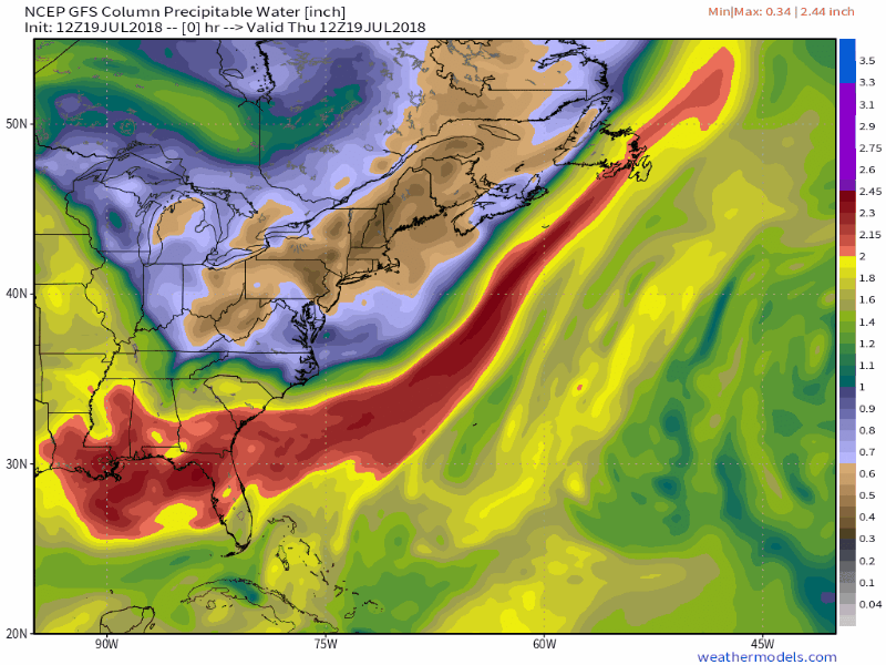
Moisture will stream northward from the tropics into much of the East Coast over the next several days. Loop provided by WeatherModels.com
While the Texas and the Southwest deal with extreme heat, the East Coast will get a little bit of relief from what has been a hot start to summer. While temperatures will still be a little above normal this weekend into much of next week, highs will only be in the 80s to lower 90s. While the temperatures won’t be that bad, humidity levels will. With high pressure anchored off the East Coast, a southerly flow will help moisture stream northward from the tropics right up the East Coast this weekend and into much of next week. Dewpoints will be in the upper 60s and 70s across the region, so even though temperatures may not be hot, it will feel oppressive across much of the region.
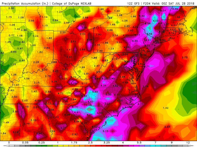
Heavy showers and thunderstorms are expected across much of the East Coast each afternoon over the next week. Image provided by College of DuPage.
With a warm and humid airmass in place for much of the week, it won’t take much for showers and thunderstorms to develop each day. With plenty of available moisture, some of these storms will end up producing very heavy rainfall. While the map above is a forecast that shows widespread coverage of heavy rain, in many cases, the storms will be very localized. Some locations could get hit by slow-moving thunderstorms over and over, while other spots a few miles away get little to no rainfall. Across the Mid-Atlantic States, where heavy rain led to flooding during the Spring, similar conditions are possible again for the next week. Across the Northeast, things are a little different.
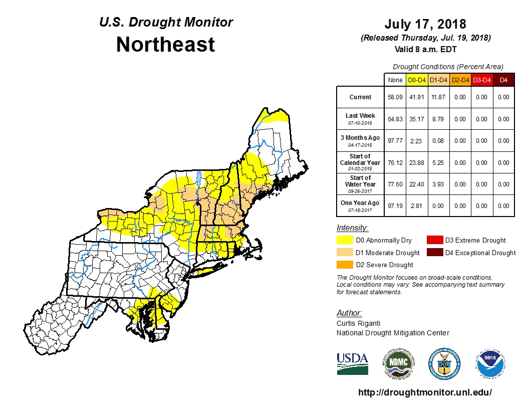
Much of the Spring has been very dry across New England and New York, with drought conditions developing. Image provided by the National Drought Monitor.
Much of the Spring has been very dry across New England and New York. Localized thunderstorms have brought heavy rain to a few spots, especially earlier this week, but overall, rainfall has been well below normal across the area. Some relief will come this weekend. A weak low pressure system will move across the region late Saturday into Sunday as an upper-level low pressure system moves into the Midwest. The surface low will bring heavy rain and some gusty winds to parts of Southern New England and southeastern New York. The heaviest rain is expected late Saturday night into early Sunday morning, so neither day should be a washout. Once that system moves by, a warm and humid airmass will settle in, with a daily chance for showers and thunderstorms this week.
This pattern is expected to remain in place through at least next weekend and possibly even longer. While none of the models are showing development of any systems in the tropics right now, this is the type of pattern that is conducive to storms impacting the East Coast. The tropics have been fairly quiet so far this season, and a relatively quiet season is expected, especially compared to last year. However, should something develop in or near the Bahamas, it wouldn’t take much for it to impact the East Coast with relatively little lead time. In 1991, a tropical depression developed in the Bahamas on August 16, 48 hours later it was a Category 3 Hurricane named Bob brushing the Outer Banks of North Carolina before slamming into Southern New England as a Category 2 storm 12 hours after that.
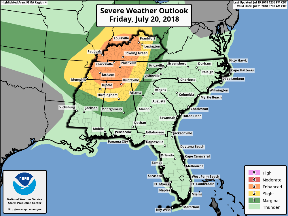
A severe weather outbreak is possible on Friday across the Ohio and Tennessee Valleys. Image provided by the Storm Prediction Center.
While Texas bakes and the East Coast sweats, an upper-level low pressure area will settle into the Midwest. With the clash in airmasses along a cold front, showers and thunderstorms will develop. Some of these storms will become strong to severe on Friday, especially across the Ohio and Tennessee Valleys. The main threats with any storms that develop will be strong winds, large hail, and torrential rainfall that could trigger flash flooding. Some tornadoes are also possible. The storms may start during the morning closer to the Great Lakes, with the afternoon and evening seeing the most widespread activity across the region. While activity should weaken at night, the threat of severe weather will continue across southern and eastern parts of the region.
Strong to severe thunderstorms are expected across the Midwest on Friday. Loop provided by WeatherModels.com
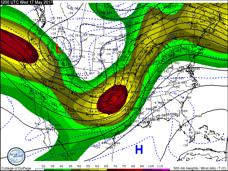
The current weather pattern across the country is one that is fairly typical of Spring. However, the results of that pattern are wintry weather in the Rockies and summer-like weather in the East. In the battlezone between the two there is plenty of severe weather, which is fairly typical of Spring.
500mb analysis map from 8am EDT May 17, shows a ridge of hgh pressure in the East and a trough of low pressure in the West. Image provided by College of DuPage.
An upper-level low pressure area will move out of the Pacific Northwest and into the nation’s midsection over the next few days. While one surface low pressure area moves into the Upper Midwest today, a second one will develop east of the Rockies and move into the Plains states on Thursday. With cold air moving in behind the system, and warm, moist air flowing northward from the Gulf of Mexico ahead of it, strong to severe thunderstorms are likely again today, Thursday, and Friday across the Plains states.
Severe weather has plagued the nation’s midsection for the past few days, with over 500 reports of severe weather between Monday and Tuesday. Nearly 30 tornadoes were reported, along with hail as large as softballs, and hundreds of reports of wind damage from gusts as high as 85 mph.
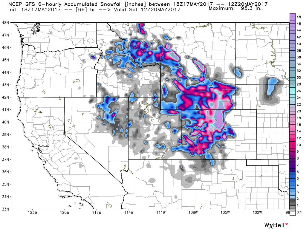
GFS model snowfall forecast through Saturday morning for the Rockies. Image provided by WeatherBell.
Behind the low pressure area, a late-season snowstorm is expected across the Rocky Mountains. Heavy snow will continue across portions of Montana and Idaho today, spreading into Wyoming and Colorado for Thursday into Friday. Across the higher elevations, totals of 1-3 feet are expected, which will keep the ski season going for a while longer. Snow may also spread into the High Plains of eastern Colorado and western Nebraska, with some minor accumulations possible. In Denver, it looks a couple of slushy inches may fall, though at least 1 model is forecasting much heavier amounts. In a normal year, Denver averages 1.7″ of snow, and the city has seen measurable snow during the month of May in 11 out of the last 16 years, so snow in May is not uncommon, though a heavy snowstorm, if it materializes, would be. Denver has only received 10 or more inches of snow in the month of May 6 times in a 135 years of records, with a record total of 15.5″ set back in May of 1898.
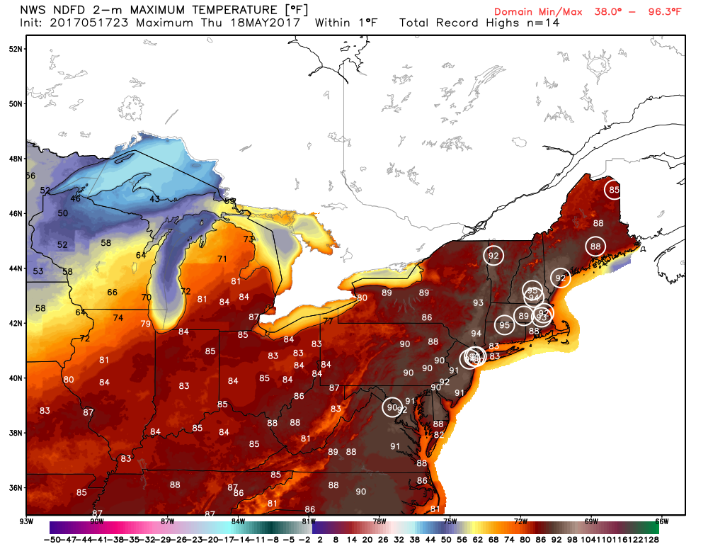
Record high temperatures are expected to be broken across the Northeast on Thursday. Image provided by WeatherBell.
Meanwhile, in the East, an early taste of summer is ongoing, thanks to a ridge of high pressure aloft, and a surface high pressure area off the East Coast. Temperatures soared into the 80s and lower 90s on Wednesday, setting several records, but the hottest day for many locations will be Thursday. High temperatures will climb into the lower to middle 90s in many locations, likely breaking records across much of the region. When you combine the heat with dewpoints well into the 60s, it will definitely feel like a mid-summer afternoon across the region. A cold front will move through the area of Friday, possibly triggering a few showers and thunderstorms, but also sending temperatures back to where they should be in the middle of May.
Severe weather is likely across portions of the Gulf Coast and Mississippi Valley today, but another, perhaps more widespread, outbreak is possible at the end of the week.
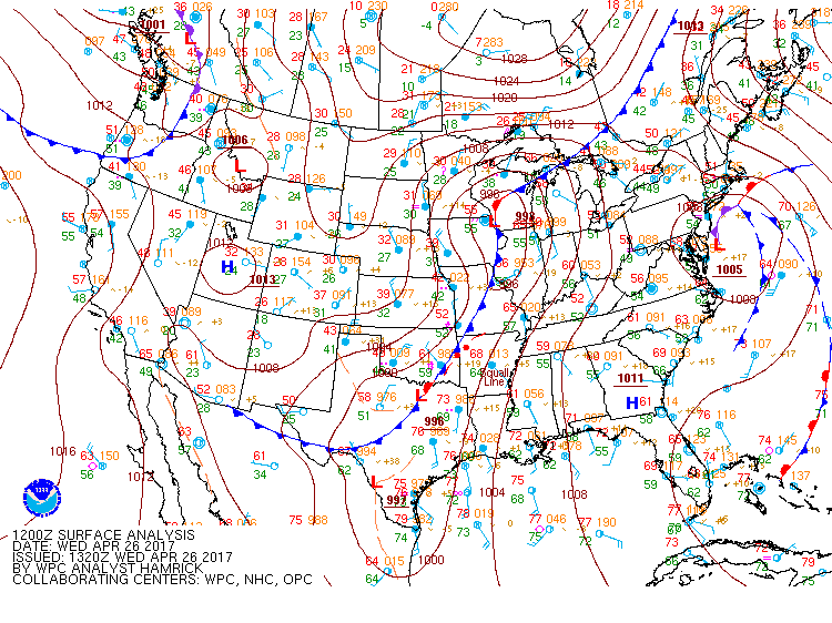
Surface analysis as of 7am CDT Wednesday April 26. Image provided by NOAA.
A strong cold front is moving into the Mississippi Valley and Texas this afternoon, and it is helping to trigger strong to severe thunderstorms across portions of the region. Ahead of the front, temperatures are into the 70s and lower 80s, with dewpoints in the upper 60s and 70s, so there’s plenty of warm, moist air in place. Behind the front, temperatures quickly drop into the 50s and 60s. Thunderstorms will continue to develop in the unstable airmass ahead of the front, with some of the storms containing large hail, heavy downpours, damaging winds, and possibly some tornadoes. Earlier this morning, some storms produced baseball-sized hail and wind gusts in excess of 70 mph in portions of Missouri, Arkansas, and Oklahoma. The threat should start to diminish across the region as we head into the overnight hours.
A more significant severe weather outbreak is possible later Friday into Saturday from the Southern Plains and Texas into portions of the Mississippi and Tennessee Valleys. Low pressure will move out of Texas and head northward, drawing warm moist air northward from the Gulf of Mexico once again. North and west of the system, much cooler air will be in place (more on that in a moment).
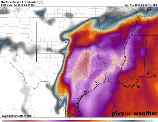
Models are showing that a very unstable airmass will be in place across Texas and the Lower Mississippi Valley Friday afternoon. Image provided by Pivotal Weather.
Models are showing that a very unstable airmass will be in place across Texas and the Lower Mississippi Valley Friday afternoon. Image provided by Pivotal Weather.
As low pressure rides along the boundary between the two airmasses, it will help to trigger strong to severe thunderstorms across the region. The threat will continue into the overnight hours Friday night, shifting into the Mississippi and Tennessee Valleys on Saturday as the system continues to progress northeastward. Some of the storms may produce torrential downpours that could trigger flash flooding, large hail, damaging winds, and tornadoes.
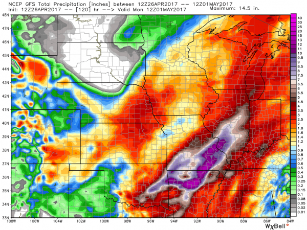
Portions of the Mississippi Valley could received 5-10 inches of rain between Wednesday and Sunday. Image provided by WeatherBell.
Behind the storm, as colder air settles into the region, a different threat is evolving – heavy snow. While it’s getting late in the season, heavy snow is not uncommon in the Central and Southern Rockies at this time of year. Some of the higher elevations in Colorado and New Mexico could receive 1-2 feet of snow Friday into Saturday. East of the Continental Divide, especially in the High Plains, snow is also possible, especially from eastern Colorado and western Kansas into portions of the Oklahoma and Texas Panhandles. In Denver, there is still a big question as to whether to precipitation falls mainly as rain, snow, or a wintry mix. Some snow accumulation seems likely at this point, but it’s still a little too early to tell whether there will be heavy snow in the city itself.
GFS model forecast for snowfall through Sunday morning across the Plains and the Rockies. Image provided by WeatherBell.
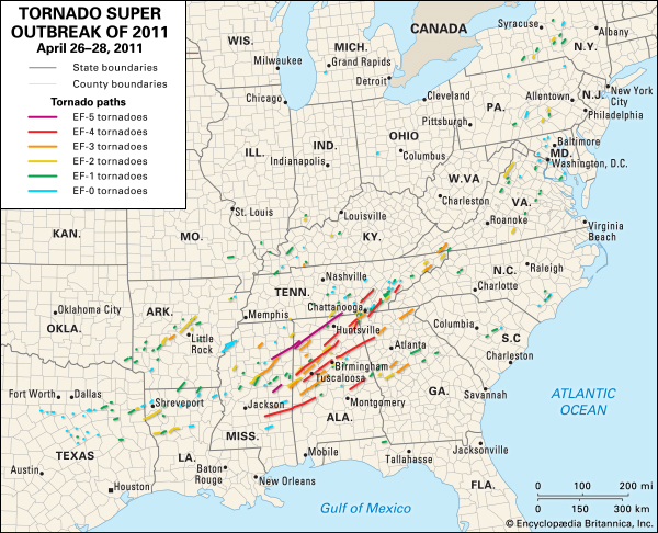
Severe weather outbreaks are not uncommon at this time of year. In fact, from late March into early May is when they are most likely. The largest tornado outbreak on record occurred 6 years ago this week. Between April 25 and 28, 2011, a total of 362 tornadoes were observed from Texas to New York and portions of southern Canada, resulting in 324 fatalities, 317 of them on April 27, the most active day.
Map showing tracks of all 362 tornadoes from the April 2011 “Super Outbreak”. Image provided by Encyclopedia Brittanica.
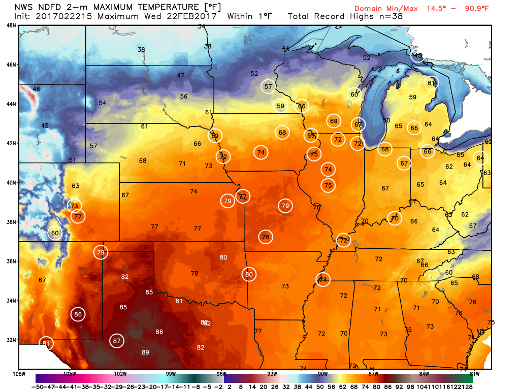
Much of the nation’s midsection has been enjoying temperatures more typical of April than February for the past week, with a few hundred record high temperatures broken. That is about to change, as Mother Nature will remind the region that is still February.
Numerous record highs are expected across the Plains and Midwest for one more day. Image provided by WeatherBell.
One more warm day is expected today, with highs well into the 60s and 70s likely setting more records. However, a cold front will sweep across the region, bringing an end to the record heat, and setting the stage for a snowstorm.
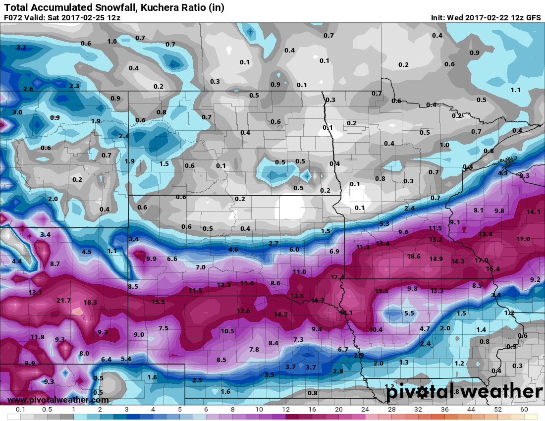
The low pressure system that brought more rain to California over the past couple of days will head eastward, bringing some snow into the Rockies today. As that system moves into the Plains on Thursday it will start to strengthen, drawing moisture northward from the Gulf of Mexico while cold air flows southward on the backside of the storm into the Northern Plains. Where these airmasses meet, snow will develop across the Central Plains states. The snow will be accompanied by winds of 20-30 mph, gusting to 40 mph or more at times, resulting in near-blizzard conditions across portions of South Dakota, Nebraska, southeastern Wyoming, and eastern Colorado on Thursday.
More than a foot of snow may fall in a swath from the Plains into the Upper Midwest. Image provided by Pivotal Weather.
As the system heads eastward, snow will move into portions of the Mississippi Valley and the Upper Midwest on Friday. The heaviest snow looks to stay just south of the Twin Cities, but even there, moderate to heavy snow is likely. By the time the storm moves out on Saturday, a foot or more of snow is possible in a swath from the Central Plains into the Great Lakes.
Snow isn’t the only threat from this system. As the storm moves eastward, record warmth will remain in place across the Midwest. With warm, moist air in place and a strong cold front approaching from the West, strong to severe thunderstorms are possible across portions of the Lower Great Lakes and Ohio Valley on Friday. Some of the stronger storms that form may contain damaging winds, hail, and possibly tornadoes.
The Storm Prediction Center has already highlighted the Midwest as an area to watch for severe weather on Friday. Image provided by NOAA.
The system will continue to move eastward, bringing some rain to the East Coast on Saturday, but amounts should be fairly light, and additional severe weather is not anticipated.
As we head into the end of August, some familiar things start to happen. Children will start to head back to school. Baseball’s pennant races heat up while football at all levels gets ready for the start of the season. Halloween candy starts to appear in stores and it will be followed shortly by pumpkin-flavored everything. In terms of the weather, familiar things happen there too. The tropics start getting more active and the cold fronts dropping southward from Canada pack a little more punch than they usually do during the summer.
One of those cold fronts will be moving across the Plains states and into the Midwest over the next few days. Ahead of the front, summertime heat and humidity remains in place, with temperatures well into the 80s and 90s common. Behind the front is much cooler and drier air. By Friday morning, temperatures will be 10-20 degrees below normal across much of the Plains states and Rocky Mountains as a large area of high pressure builds in from Canada. Low temperatures will drop into the 40s and 50s across the Northern Plains, with 30s and even some upper 20s from the Rocky Mountains into interior portions of the Pacific Northwest.
Temperature anomaly map based on the GFS model for Thursday morning. Image provided by Pivotal Weather.
As that cooler air settles into the region, some snow is possible across the higher elevations of the Northern and Central Rockies. Snow levels will remain fairly high, but a few inches of snow may accumulate on top of some of the higher peaks in Wyoming and Colorado.
Snowfall forecast based on the GFS model through Friday morning. Image provided by WeatherBell.
Ahead of the front, a warm and humid airmass will remain in place, with high temperatures well into the 80s and 90s for the next few days. As the front approaches, it will trigger showers and thunderstorms. Some of the storms could be strong to severe, with hail and gusty winds possible, along with a few tornadoes. The biggest threat looks to be heavy rain and flash flooding. Because the front will be moving fairly slowly, some of the heavier storms will linger over the same areas. Rainfall totals of 1-3 inches will be common across parts of the Eastern Plains and Mississippi Valley, with some heavier amounts possible. This will likely lead to flooding in some areas.
Expected rainfall totals across the Midwest through Friday morning. Image provided by WeatherBell.
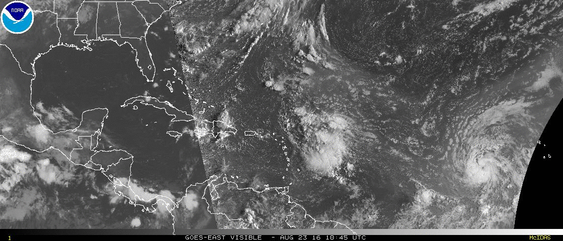
Meanwhile, in the Atlantic, we’re keeping an eye on a disturbance east of the Lesser Antilles and Tropical Storm Gaston out in the Central Atlantic. There was a third system, Tropical Depression Fiona, but it fizzled southeast of Bermuda earlier today.
Satellite photo showing Tropical Storm Gaston (far right) and a disturbance approaching the Eastern Caribbean. (Click for loop) Provided by NOAA.
Tropical Storm Gaston is centered about 700 miles west of the Cape Verde Islands this afternoon, heading towards the west-northwest at 21 mph. Maximum sustained winds are near 65 mph, and additional strengthening is expected. Gaston should become a hurricane by Wednesday afternoon. The forecast for Gaston is to turn more towards the northwest, heading out in the Central Atlantic Ocean before starting to weaken in a few days. Gaston will likely bot be a threat to any land areas.
Meanwhile, a disturbance located a few hundred miles east of the Lesser Antilles is being carefully monitored for signs of development. United States Air Force Reserve Hurricane Hunter aircraft investigated the system earlier today and found it to be a weak system with an ill-defined center. Conditions are still somewhat favorable for further development, and anyone with interests in the northeastern Caribbean should continue to monitor the progress of this system. The future of this system is still a big question mark. Most of the forecast models bring the system towards the Bahamas over the next several days, though a few have the system dissipate completely before then. Once it gets to the Bahamas, there is considerable spread among the models as to where it will go, assuming it even survives that long. Some have it turn northward and head towards the Carolinas or Georgia. Some bring it into Florida, then up into the Southeast, and others bring it across Florida and into the Gulf of Mexico. As for how strong it could be, that’s an even bigger question mark. As mentioned previously, some of the models have it dissipate completely. There are other models that keep the system as a tropical depression or weak tropical storm into the Bahamas. There are others that have it as strong as a Category 2 hurricane. Once the storm actually forms (assuming it actually does), the computer models should start to get a better handle on its future.
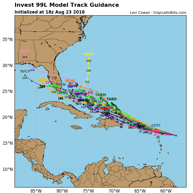
Computer model forecasts for the track of a disturbance approaching the Eastern Caribbean. Image provided by Tropical Tidbits.
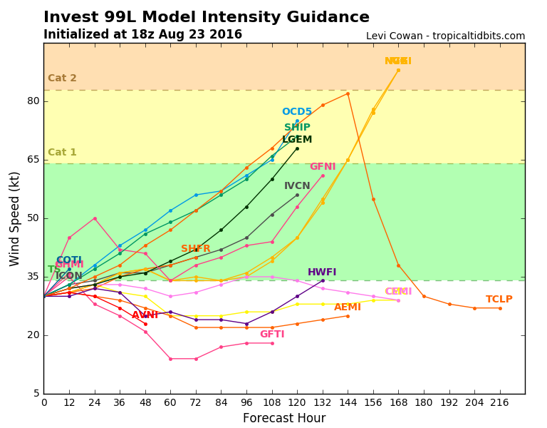
Computer model forecasts for the intensity of a disturbance approaching the Eastern Caribbean. Image provided by Tropical Tidbits.
Severe weather has been widespread across the eastern half of the nation for the past 2 days, but high pressure will bring much quieter conditions this weekend.
A cold front has been slowly dropping southward over the past 2 days, replacing warm and humid air with cooler and drier conditions. Ahead of the front, strong to severe thunderstorms have cut a large swath of damage.
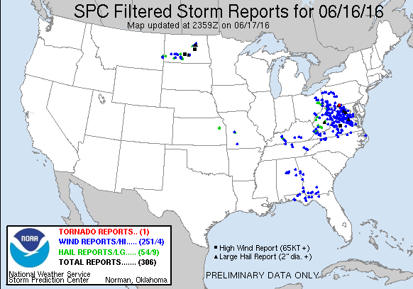
Reports of severe weather from Thursday June 16. Image provided by the Storm Prediction Center.
On Thursday, severe weather was widespread across the Mid-Atlantic states from mid-afternoon through the late evening hours. There were over 250 reports of damage from wind gusts as high as 77 mph, with a majority of the reports concentrated in West Virginia, Virginia, and Maryland, including the Washington, DC metropolitan area, where thunderstorms dropped 2.58″ of rain in just a couple of hours at Dulles Airport. In addition to the wind damage and heavy rain, hail as large as baseballs was observed with some of the strong storms. One tornado was also confirmed in Barnes Gap, Pennsylvania.
While most of activity quieted down in the evening, thunderstorms flared up across North Dakota and Minnesota. A cluster of storms moved across the state early in the morning, producing baseball-sized hail near Bismarck. Wind gusts as high as 80 mph were also reported across the region.
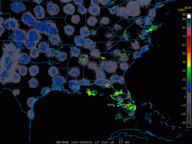
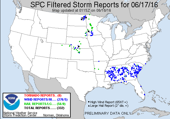
Radar loop for the Southeast from Friday afternoon June 17. Loop provided by the College of DuPage.
By Friday afternoon, activity started to flare up again across the Southeast ahead of the cold front. A line of strong to severe thunderstorms quickly developed from Mississippi to South Carolina and began to march southward. Widespread wind damage was reported across the region as wind gusted as high as 70 mph in some of the stronger storms. These storms also produced torrential rainfall, with 2.32″ falling in one hour in Columbus, Mississippi.
Reports of severe weather from Friday June 17. Image provided by the Storm Prediction Center.
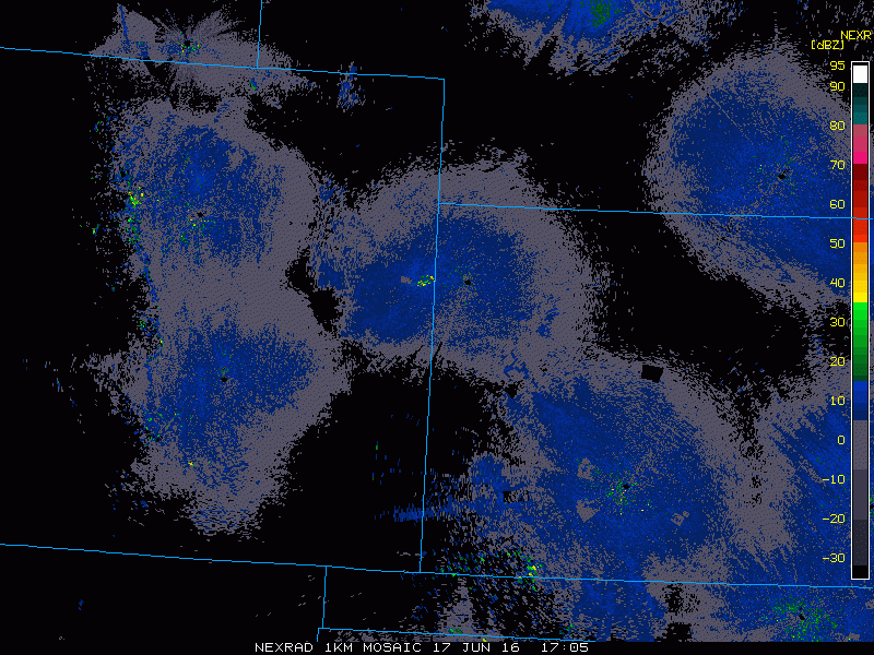
Across the Plains states, under sunny skies temperatures soared well into the 90s and lower 100s on Friday. Another cold front moving into the Western Plains provided the necessary lift to trigger thunderstorms across portions of Kansas and Nebraska. Once the activity got going, it quickly exploded into a large cluster of strong to severe thunderstorms. In McCook, Nebraska, the temperature reached 99 degrees during the afternoon with a dewpoint in the upper 60s to lower 70s. As a severe thunderstorm moved into the region, it produced a wind gust to 72 mph and dropped over 2 inches of rain on the area. It also sent temperatures tumbling into the middle 60s.
Radar loop for Kansas and Nebraska from Friday afternoon June 17. Loop provided by the College of DuPage.
Much quieter conditions are expected over the weekend as a large area of high pressure builds into the eastern half of the nation. Sunshine and seasonably warm temperatures are expected for most of the region, with thunderstorm activity mostly confined to the Gulf Coast, near the dying frontal boundary that produced severe weather over the past few days, and the Northern Plains, where a strong cold front will slowly move through this weekend.
After Sunday’s cold front ushers in cooler and drier air for Monday in the Northern Plains, a warm front will push north Tuesday. This warm front is attached to a low pressure system that will be moving northeast through the Rockies and into the Northern Plains. Areas in between the northward moving warm front and the southeastward moving cold front could see some strong to severe thunderstorms on Tuesday. This would mainly occur in the eastern Central Plains and portions of the Middle Mississippi Valley where convective energy, CAPE, and turning of the winds, shear, overlap to be able to support these storms.
Cooler and drier air (green colors) moving into the Northern Plains behind a cold front. Courtesy of College of Dupage.
A warm front nestled between North and South Dakota. Courtesy of College of DuPage.
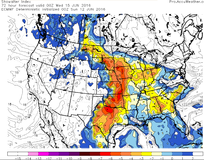
Showalter Index showing possible instability with negative values in the Northern Plains, but even lower negative values occur in the Eastern Central Plains and Middle Mississippi Valley. Courtesy of AccuWeather.
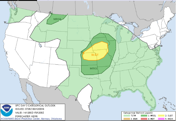
Severe weather categorical outlook for Tuesday showing the highest probability of severe weather in the Central Plains and Middle Mississippi Valley. Courtesy of the Storm Prediction Center.
Farther north along the warm front in the Northern Plains, factors like limited sun exposure, saturated atmospheric columns and a lack of a shear/CAPE overlap may preclude strong to severe thunderstorms all together. There is some question as to how far north the warm front will be able to push into North Dakota so if it is able to push farther north and allow more sun, some strong to possibly severe thunderstorms may occur. At the very least, some thunderstorms may be embedded in what does appear to be a heavy rain event as a result of a vigorous upper level disturbance that appears to go negatively tilted in the upper levels of the atmosphere. This negative tilt allows for a strong draw of moisture into the system as a result of a strong low level jet stream. At the same time, very moist low levels and total column precipitable water values between 1.5 and 2 inches get wrapped around the northeastward moving low pressure system bringing the potential for a heavy rain event into the Northern Plains. Furthermore, large scale lift as a result of a collocated upper level jet stream will help to support the event. All told, 1 to 2.5 inches of precipitation in 24 hours from morning Tuesday to morning Wednesday seems reasonable for this event, but could be higher in any embedded thunderstorm.
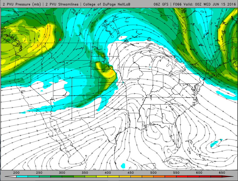
The vigorous possibly negatively tilted energy moving into the Central and Northern Plains. Courtesy of College of DuPage
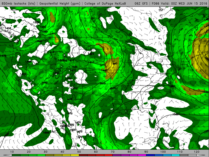
Strong low level jet in the Northern Plains along with the Central Plains and Middle Mississippi Valley helping fuel heavy rain and strong to severe thunderstorms respectively. Courtesy of College of DuPage.
Forecast rainfall totaling 1 to 2.5 inches. Possibly higher in any thunderstorms from Tuesday morning to Wednesday morning. Courtesy of the Weather Prediction Center of NWS.
It is also interesting to note that the ECMWF model contains around an inch less of precipitation than the GFS model, with the NAM model being closer to the mean of the two models despite the ECMWF model reaching the above parameters. With this in mind, it appears any flooding risk would be low, but could still occur if the higher end of the precipitation range is realized.
The low pressure system is forecast to move away from the Northern Plains allowing for drier air to come in for Wednesday and Thursday. However, clouds are forecast to return as another low pressure system ejects off the Rockies for Friday allowing for some more rain.
For the second weekend in a row, there is a threat for severe weather across parts of the Northeast. Unlike last weekend, when the threat was centered on areas from the Delmarva Peninsula southward to the Carolinas, the threat on Saturday is focused on the Northeast.
Strong to severe thunderstorms moved across the Midwest Friday evening. Loop provided by College of DuPage NexLab.
Low pressure is moving across Lake Superior this evening, with a warm front extending east and southeast from the system across the eastern Great Lakes and into Virginia. A cold front trails the system into the Dakotas and Wyoming. South of these two fronts a very warm and humid airmass is in place, with temperatures well into the 80s and 90s on Friday. Dewpoints were in the 60s to lower 70s across much of the region as well. As the cold front moved into the Upper Midwest, it helped ignite a line of strong to severe thunderstorms. These storms produce golfball-sized hail and wind gusts as high as 76 mph as they cross Minnesota and Wisconsin Friday afternoon and evening.
Usually, strong to severe thunderstorms diminish during the evening hours as they lose the heating of the sun. However, with the warm and humid air in place across the Midwest, these storms will likely continue to march eastward overnight ahead of the cold front.
Radar loop predicted by the NAM model from Friday night into Sunday night. Loop provided by College of DuPage NexLab
Forecast models indicate that this line of thunderstorms will move across portions of New York and Pennsylvania Saturday morning and afternoon before moving into portions of New England. How far north and east the warm front moves will help determine where the best chance for severe weather will be located.
High temperature forecast for Saturday afternoon based on the NAM model. Image provided by WeatherBell.
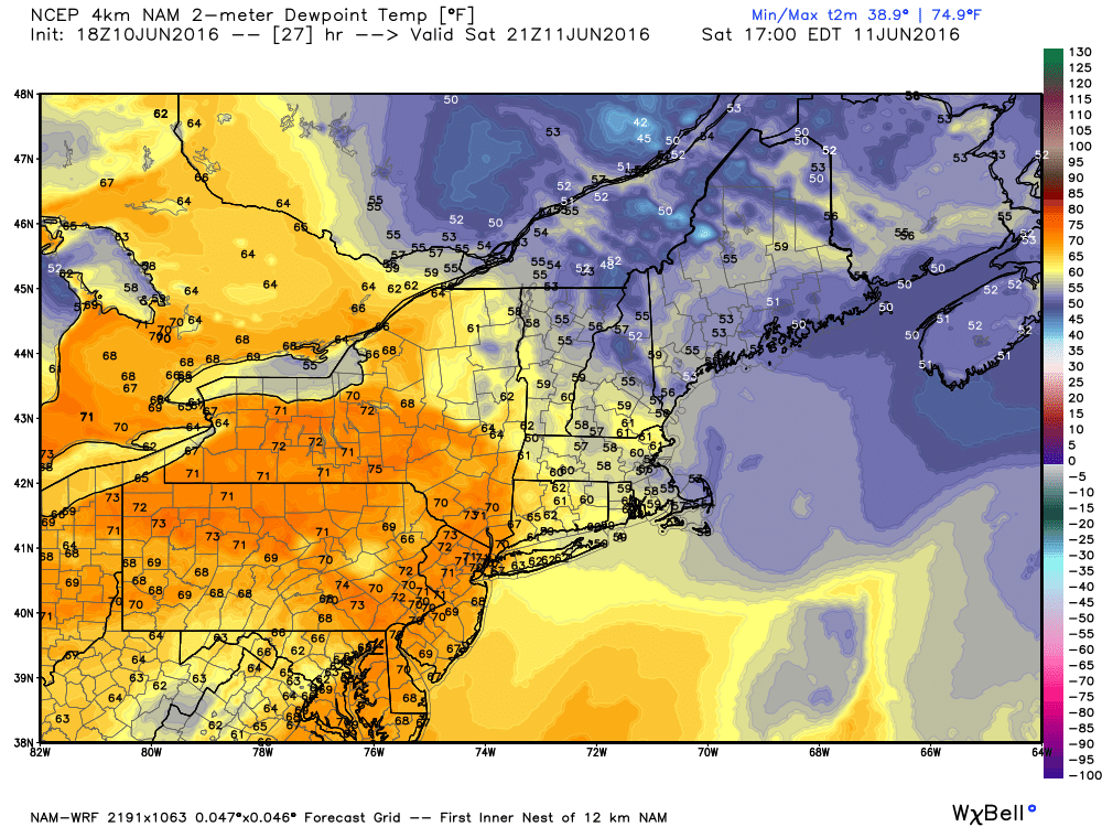
Dewpoint forecast for Saturday afternoon based on the NAM model. Image provided by WeatherBell.
Right now, it looks like the warm front will only make it into New York and southwestern New England before the cluster of showers and thunderstorms arrives. Some of the stronger storms could produce downpours, strong winds, and hail across portions of New York, Pennsylvania, and New Jersey.
Across New England, the threat for the afternoon seems less, with more typical showers and thunderstorms expected. However, this does not mean that the threat is zero. If the warm front were to make progress farther northward, the threat would increase. The bigger threat in this region could come at night. The warm front should eventually push through during the evening, allowing the warm and humid air to move into Southern New England. As the cold front continues it eastward march, another round of showers and thunderstorms will likely develop along and ahead of it. As these storms move across New England overnight, some of those storms could produce heavy downpours and strong winds.
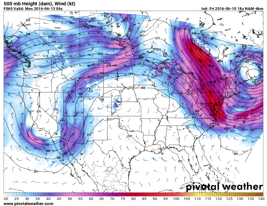
Forecast for 500mb heights and winds based on the NAM model. Image provided by Pivotal Weather.
After the cold front moves through Saturday night, skies should become partly to mostly sunny across the Northeast on Sunday with near-to-below normal temperatures expected. An upper-level low will slowly move across the Gulf of Maine early next week, keep temperatures near or below seasonal normals while heat and humidity dominate the remainder of the eastern two-thirds of the nation.