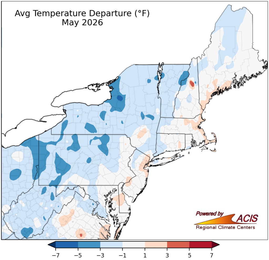
May 2026 was cooler than average for much of the Northeast, but the past week or two have seen warmer temperatures, though that might change this weekend.
Cooler temperatures were the norm for May 2026, with most of the region being at or below average temperature. Image provided by the Northeast Regional Climate Center.
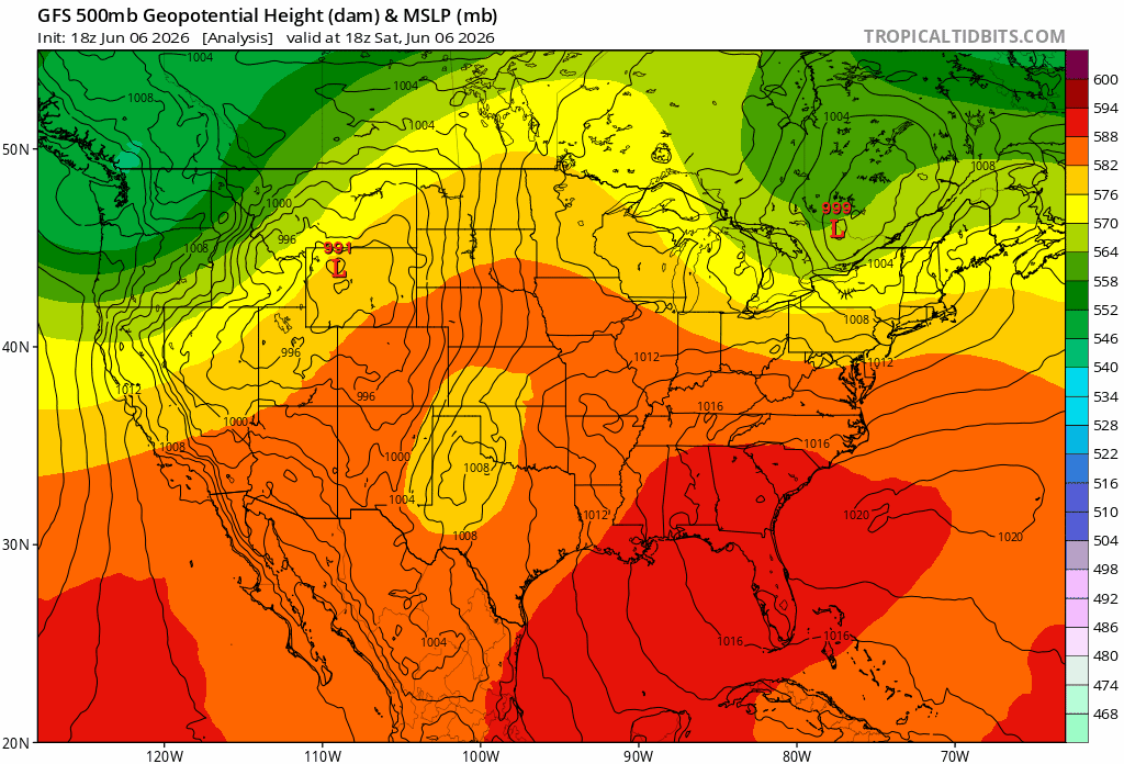
A back door cold front is moving through the northeast, bringing short relief from the heat, but a ridge of high pressure in the north central US is giving way to severe weather expected to move across the northern US. Temperatures in the 80s and 90s are expected until the weekend, as a large area of low pressure follows the severe weather, bringing highs in the 60s to 70s for the East, and potentially into the 50s in the Central US.
A High pressure ridge over the Central US gives way to severe weather, followed by lower pressure over much of the northern US. Loop provided by Tropical Tidbits
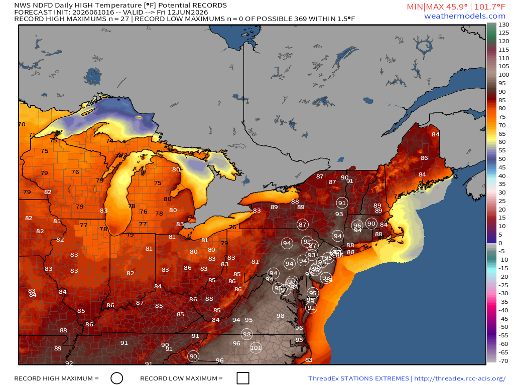
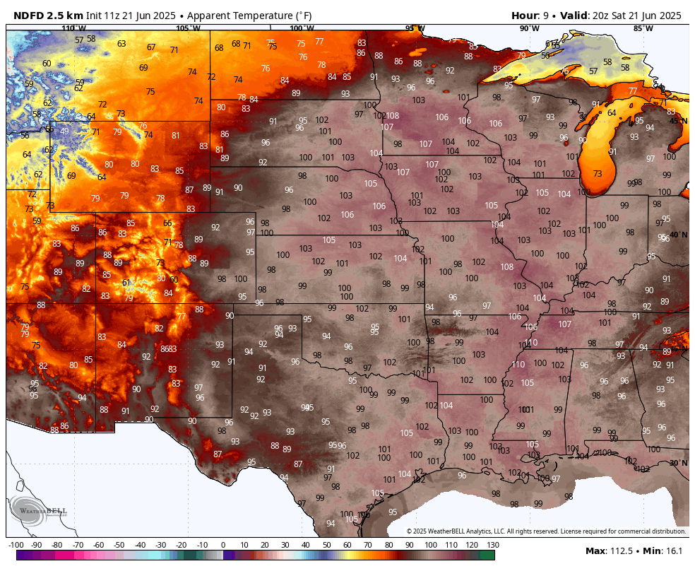
The warmest weather is expected on Thursday and Friday, as the high pressure sets up offshore, bringing warm humid air up the coast. Records could be set once again along the I-95 corridor, with temperatures well into the 90s, potentially reaching triple digits in North Carolina. Water temperatures along the coast have warmed up, with temperatures in the 50s and 60s along New England and into the 80s along the Southeast and Gulf Coast, providing some relief for people heading to the beaches. Cool temperatures should return over the weekend as a cold front moves through the region.
Record highs are expected through eastern US on Friday as a high pressure ridge sets up off the coast. Image provided by Weathermodels.com
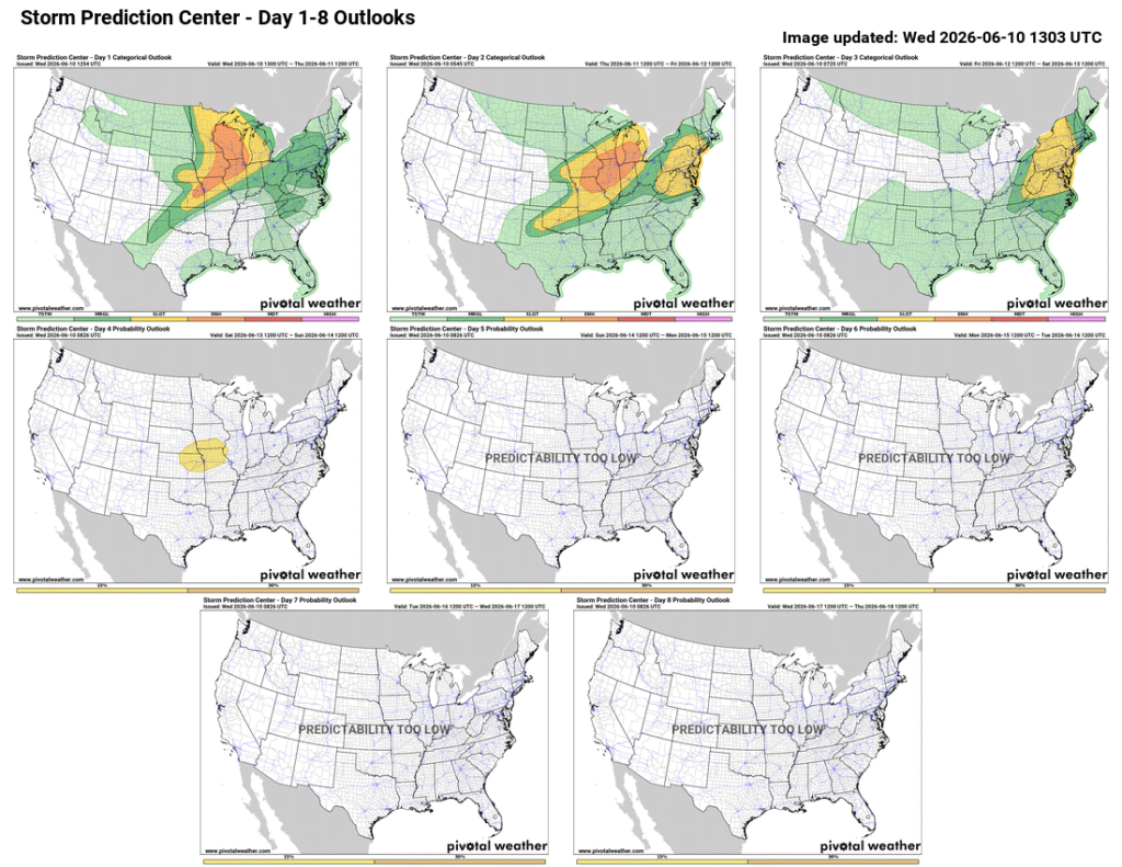
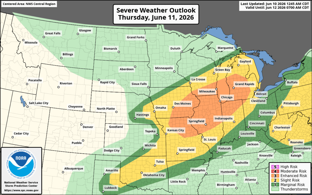
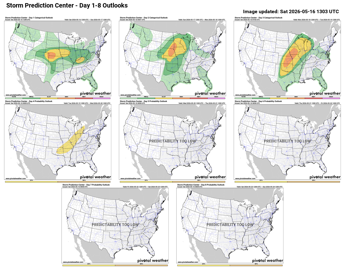
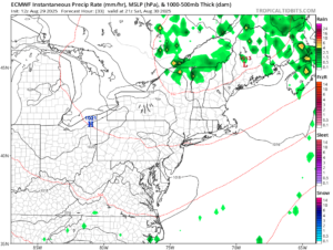
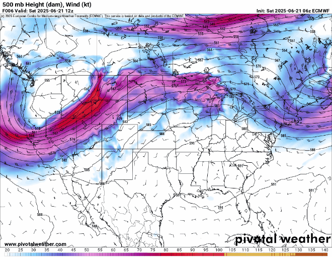
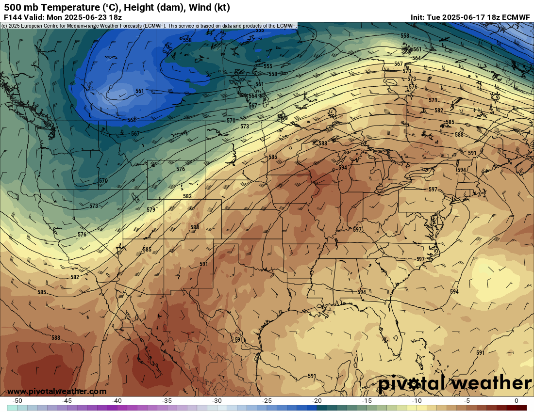
While the Eastern US can expect severe weather on Thursday and Friday, most of the Midwest is looking at severe weather continuing into Thursday.
Severe weather is likely to continue in the Central US Wednesday and Thursday, with the East Coast expecting some on Thursday and Friday. Image provided by Pivotal Weather
A low pressure trough pushing through a high pressure ridge promoted development of severe weather Tuesday night, which is expected to continue into Wednesday night and Thursday. Strong to severe thunderstorms are likely from the Central Plains northeastward into the Great Lakes, with an area developing along the East Coast on Thursday. Today, much of the Midwest can expect severe weather to continue, bringing strong winds, hail, and potentially tornadoes to the region, with a stronger wind threat Thursday, alongside continued hail and tornado risks.
The North Central Plains and Upper Midwest are looking at several rounds of storms tonight into Thursday. Image provided by NOAA.
As the system moves through, high pressure builds in behind it, bringing cooler temperatures and calmer weather. The East Coast can expect cooler weather on the weekend as the high makes its way to the region.
Winter of 2025-2026 left the snowpacks of the Rockies in a dire state. Combined with one of the warmest winters on record and a looming El Nino, most Western states are looking at a worsening drought for the summer. Cities across the West saw record low snowfall and record high temperatures this past winter. Combined with an abnormally warm March, snowpack in the mountains is at the lowest it has been since records were first kept.
Map showing snowpack percent of median from 1991 to 2020 as of May 26. Most of the region is significantly below the average, reporting around or below 40% of the median snowpack. Image provided by the US Department of Agriculture
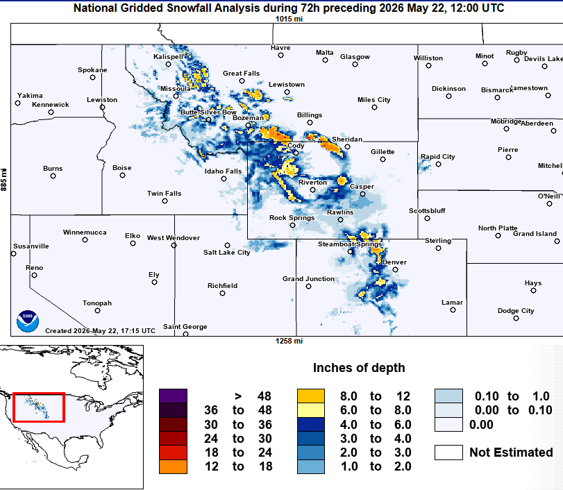
In portions of Colorado, Wyoming, and southwestern Montana, most of the season snowfall occurs during the fall and in the Spring, not in the winter like much of the remainder of the nation. This year, the majority of the snow has fallen in the Spring, with multiple late season snowstorms have helped to replenish the snowpack. Most of this is falling in the mountains, where the majority of the snowpack typically resides.
72 Hour snowfall reports from May 22nd in the Rockies. Parts of western Montana, Wyoming, and Colorado received at least 8 to 12 inches of snow between May 19 and May 22. Image provided by NOAA
Low snowpack in the West, combined with warmer temperatures earlier in the year, have detrimental effects going into both Spring and Summer. Normally, warmer temperatures arrive in during May and June, allowing the snowmelt to provide a semi-constant source of water, keeping soils moist and vegetation wetter into the warmer months. With the snowpack being at effectively zero this year, it creates an environment that is prime for wildfires, as vegetation and soil dry out early in the season.
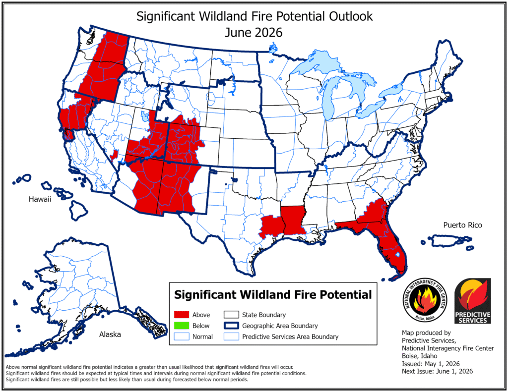
An above average significant wildlands fire potential exists for Florida, the mid-southwest, and northwest for June 2026. Image provided by the National Interagency Fire Center.
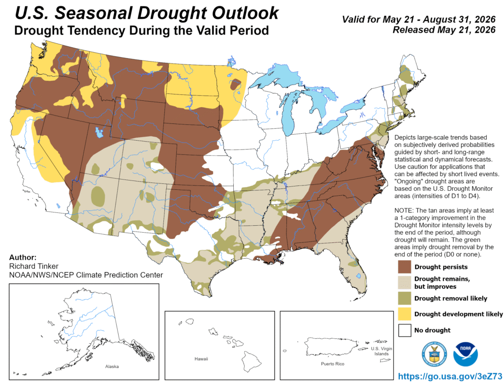
With below average precipitation and above average temperatures expected in the coming months, the drought that has been gripping the region is also expected to expand, further increasing the risk of wildfires. Alongside the increased risk of wildfires as the season starts earlier comes the increased risk of more severe wildfires as more vegetation becomes drought stressed.
While drought conditions may improve in the Southwest, they will likely worsen across much of the remainder of the West over the next few months. Image provided by NOAA
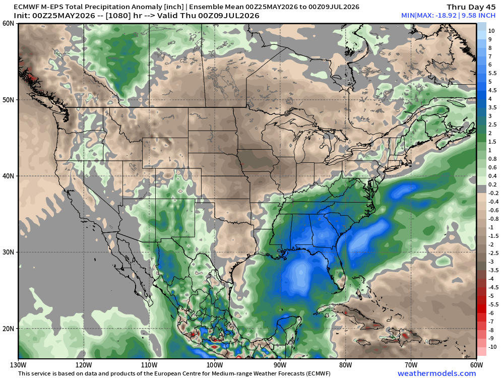
Over the several weeks, precipitation across most of the Central and Northern US is expected to be below normal. Rainfall should continue across much of the Southeast, alleviating drought concerns there. Similar conditions are also expected in the Southwest as the annual monsoon develops.
Precipitation is expected to be below normal for much of the Central and Western US, with the Southeast and parts of the Southwest seeing some relief. Image provided by Weathermodels.com
With a developing El Nino, more rainfall is expected across the southern tier of states over the coming months, with drier conditions to the north.
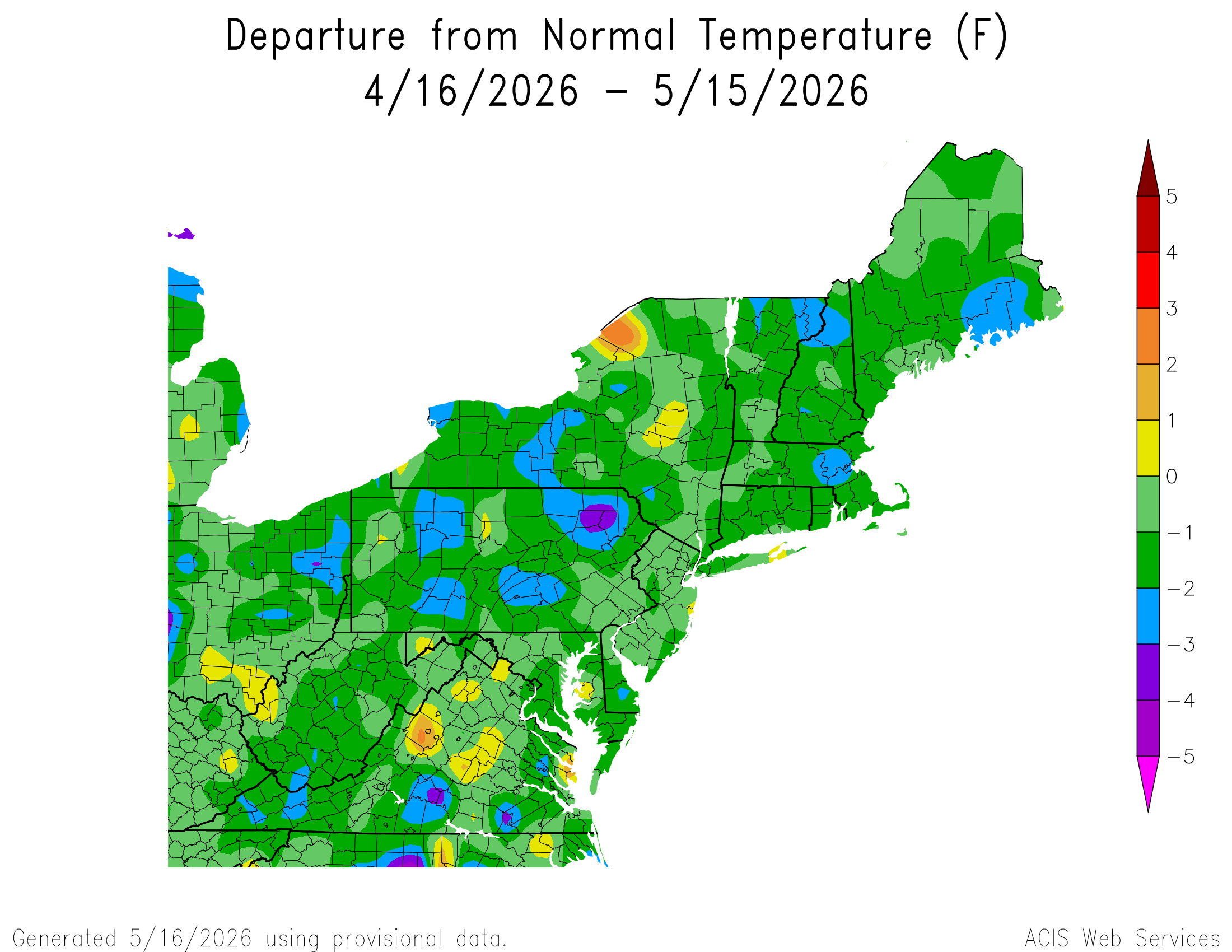
Much of the Spring has featured an upper-level trough of low pressure across the Northeast, but that will change this weekend.
Temperatures have been below normal across most of the Northeast since mid-April. Image provided by the Northeast Regional Climate Center.
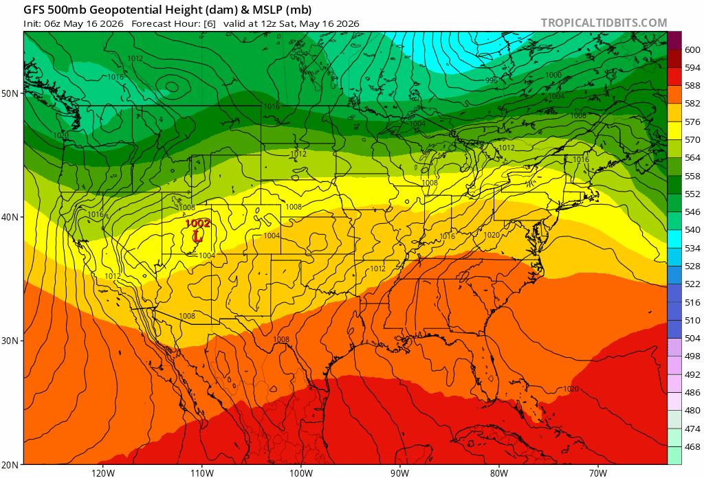
A persistent trough of low pressure has kept temperatures below normal across the Northeast for much of the past several weeks, but a ridge of high pressure will build in this weekend, both at the surface and aloft, resulting in some much warmer weather. Temperatures will get well into the 70s and 80s this weekend, with some spots topping 90. A weak backdoor cold front will bring cooler weather to parts of New England Sunday night and Monday, with temperatures only in the 60s and lower 70s, especially near the coastline, but inland areas, especially outside of New England, should get well into the 80s and lower 90s.
A ridge of high pressure will build into the East over the next few days. Loop provided by Tropical Tidbits.
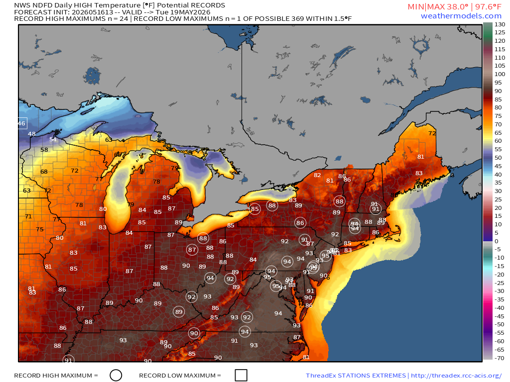
The warmest weather is expected Tuesday and Wednesday with high pressure anchored offshore. Southwest winds will bring warm and increasingly humid air to much of the East Coast, with high temperatures well into the 80s and 90s, likely setting records in many locations along the Interstate-95 corridor. Anyone heading to the beach for relief should remember that the water is still relatively cold as it is early in the season. Water temperatures are only in the 40s and 50s off the coast of New England, and 50s and 60s off the Mid-Atlantic coastline. A strong cold front will bring an end to the heat later Wednesday, possibly with some strong to severe thunderstorms accompanying that front.
Record highs are possibly in many locations in the Northeast Monday through Wednesday. Image provided by Weathermodels.com
While areas in the East Coast are looking at the potential for severe weather on Wednesday, many spots in the Plains states and Midwest could see several waves of severe weather over the next few days.
A multi-day severe weather event is likely across the nation’s mid-section. Image provided by Pivotal Weather.
Low pressure developing in the southwestern Plains states will only slowly move northeastward over the next few days. Strong to severe thunderstorms are likely this afternoon and evening from the Central Plains eastward into parts of the Mississippi and Ohio Valleys. Areas from eastern Colorado across Kansas and Nebraska and into Iowa are under the gun today, with some of the stronger storms likely producing damaging winds, large hail, heavy downpours, and tornadoes. As the system slowly moves out of the Plains states and toward the Upper Mississippi Valley on Sunday, the focus of severe weather will shift into parts of the Northern and Central Plains and Upper Midwest, especially from Nebraska into Iowa and parts of Minnesota. Once again, storms may produce strong winds, large hail, heavy downpours, and tornadoes.
The Central Plains will be under the gun for multiple rounds of severe weather over the next few days. Images provided by the Storm Prediction Center.
By Monday, as the system moves into the Great Lakes and drags a strong cold front behind it across the Plains states, a very active day is expected from northern Texas northeastward to Michigan. Widespread strong to severe thunderstorms are likely, but the area from northern Oklahoma to Iowa is where the strongest storms are expected, with many supercells producing large hail, damaging winds, and numerous tornadoes. As the front moves eastward the threat for severe weather on Tuesday will shift to parts of the Great Lakes and Ohio Valley, as well as the southern Plains, and then potentially to parts of the East Coast and Tennessee Valley on Wednesday.
Drought conditions continue across a large portion of the nation. Image provided by the National Drought Mitigation Center.
There is a bit of a silver lining to this, as widespread rainfall, some of it heavy, is likely across a large portion of the nation’s mid-section. Much of this region, especially the Central and Southern Plains, is in the middle of a significant drought, so any rain is beneficial, and will help put a dent in the drought, especially as the growing season gets underway.
Another late-season snowstorm is possible across parts of the Intermountain West and the Rockies late this weekend and early next week. Image provided by WeatherBell.
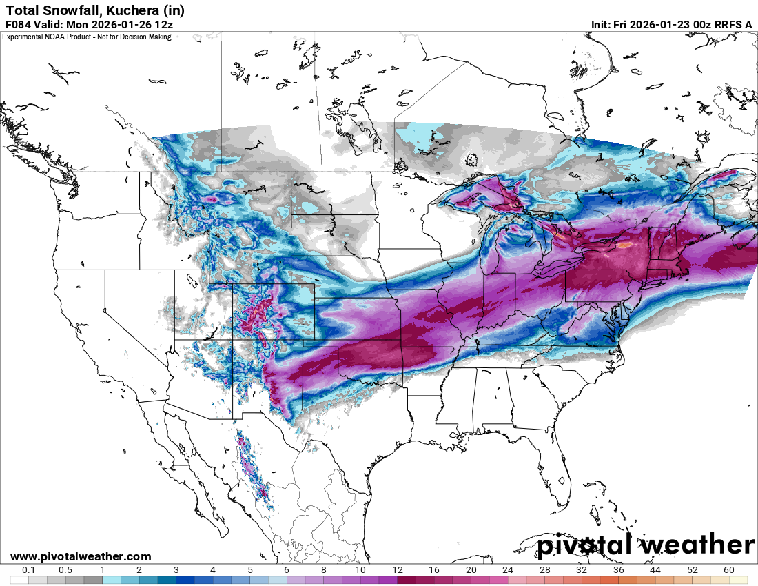
Behind the cold front, much colder air will settle into the Plains states and the Rockies. Some record lows are possible both Monday and Tuesday morning as temperatures drop into the 20s and 30s. At the same time, another low pressure system will be moving across the Great Basin, and as it encounters the colder airmass, snow is expected across the mountains, with much-needed rain at the lower elevations. Winter Storm Watches have already been issued for parts of Wyoming for late Sunday and Monday, and more are likely to be issued for parts of the region, including Utah and Colorado, later today. Some of the mountains could pick up as much as 1-2 feet of snow, possibly even more in spots. Some flakes could mix in with the rain in the Denver area Monday and Monday night, with accumulations likely in the foothills west of the city. After a fairly dry winter, the snow is welcome, as it will help with spring runoff.
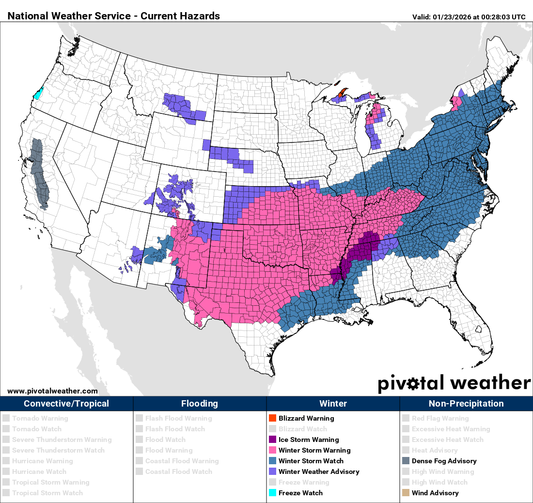
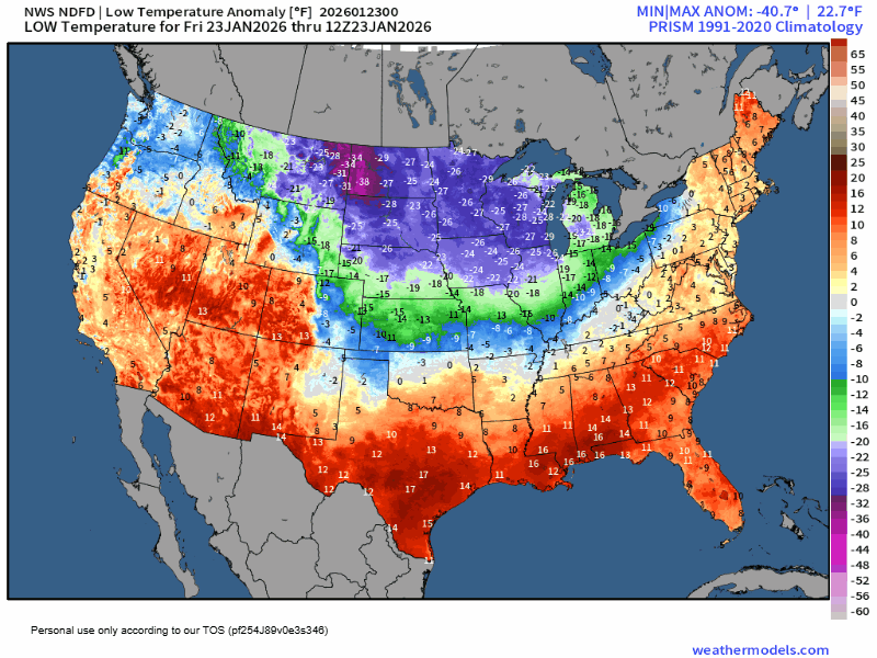
As an arctic airmass pours into the eastern two thirds of the nation, a developing low pressure system will bring wintry weather to many areas that are unaccustomed to it.
A variety of winter storm watches, warnings and advisories are in effect from the Rockies to the East Coast. Image provided by Pivotal Weather.
The overall weather pattern so far this winter has been dominated by a trough of low pressure centered over the Great Lakes with ridging taking place across either the Southeastern U.S. or the Rockies. The eastern troughs have expanded and contracted as the polar vortex has expanded and contracted this winter season. This has led to colder than normal temperatures from the Great Lakes to the Northeast since the middle of November, although there was a brief thaw back in early January. In addition, this pattern has resulted in weather systems generally moving into the region from the west or northwest. This is has led to some fairly frequent snow events through the winter but none of them have had much moisture to work with, so snowfall has generally been on the light side, except for lake-effect events. This has been due to the storms originating in areas with not a lot of moisture limiting the potential snowfall from them.
Temperatures have been below normal across the Great Lakes and Northeast since mid-November. Image provided by WeatherBell.
The pattern is in the midst of a change as there’s been a major expansion of the polar vortex over the last week. This is going to result in a deep trough developing over the eastern half of the country over the next few weeks. The pattern is shifting to one where colder airmasses will be moving into the region on a regular basis through early February. These airmasses will also be settling further south on a more regular basis over the next couple of weeks. In addition, storm systems will start to develop along the arctic boundary further south in the country which will allow these potential storms to tap into moisture from the Gulf of Mexico. In laymen’s terms, the pattern is becoming much more dynamic and our exposure to heavier snowfalls is increasing quite a bit over the next 2-3 weeks, especially in comparison to what we’ve seen so far this winter.
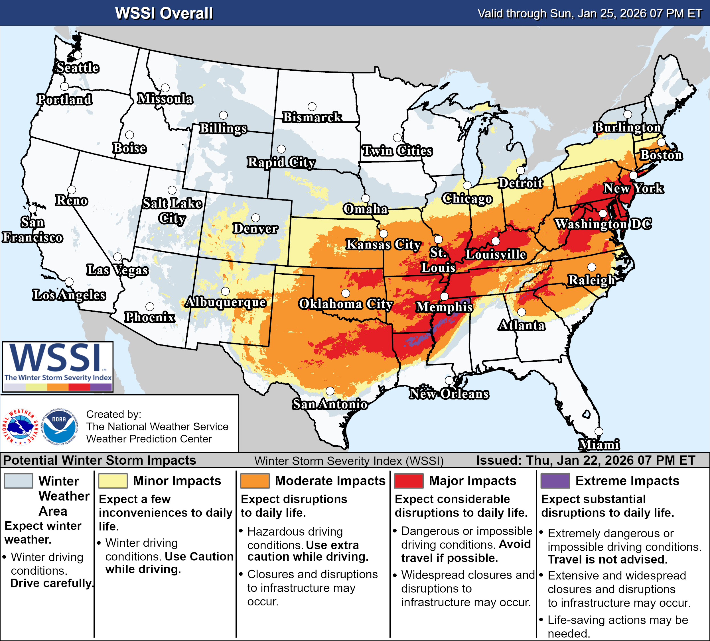
A storm system will result in significant impacts from Texas and the Southern Plains to the East Coat. Image provided by the Weather Prediction Center.
That starts over the next few days as arctic air pours into the nation while a low pressure system moving out of the Southwest encounters that colder air. It will draw moisture northward from the Gulf, and as it encounters that colder air at the surface, it will fall as freezing rain in a large swath from parts of Texas and the Southern Plains across the Tennessee Valley and into parts of the Southeast and Mid-Atlantic states. Some significant ice accretions are possible from parts of northeastern Texas and southern Oklahoma across Arkansas, northern Mississippi, Tennessee, and Kentucky, into the Carolinas and Virginia, beginning later Friday in western parts of this region, late Saturday as you head toward the Carolinas. Just to the north of these areas, where the cold air is a little deeper, some significant sleet is possible, especially in parts of Oklahoma and Arkansas. This will be a long duration storm, with precipitation likely not ending until Sunday for much of this region. This will likely cause widespread travel disruptions and power outages, with extended recovery times expected.
The system will produce a variety of weather as it makes its way across the nation. Loop provided by WeatherBell.
Farther north, heavy snow will be widespread north of the track of the low pressure system from the Southern Plains to the Ohio Valley. Many locations could pick up a foot or more of snow. Across the eastern Great Lakes, the snow will be enhanced by lake-effect snow as the arctic air moves in. Areas downwind of Lake Ontario could see totals upwards of 2-3 feet.
Heavy snow is likely from the Southern Plains to the Midwest and parts of the Northeast. Image provided by Pivotal Weather.
As the system moves to the East Coast, things become a little more complicated. The storm will strengthen, but the exact track it takes has a big impact on what type of precipitation falls, and how much accumulates. Right now, it looks like snow will change to sleet and freezing rain Saturday night and early Sunday across much of Virginia and the Delmarva Peninsula, including the Washington and Baltimore areas, with plain rain right along the coast. This will keep snow accumulations significantly lower. The changeover should get into the Philadelphia area and parts of New Jersey as well Sunday evening, which would result in lower accumulations. To the north, moderate to heavy snow is expected in parts of New York and central and southern New England, but again, a track farther north could bring sleet and/or rain into parts of Long Island and southern New England, possibly into New York City as well. Up here, snow won’t even begin in New York until daybreak Sunday, and in parts of southern New England until later Sunday afternoon or evening. Precipitation won’t end in these areas until sometime on Monday, possibly Monday night or early Tuesday in eastern New England. Once again, in places where precipitation falls as all snow, many areas will pick up a foot or more.
Well below normal temperatures will continue east of the Rockies for the next week or more. Loop provided by Weathermodels.com
Another surge of arctic air will settle in behind this storm across parts of the nation’s mid-section by the end of the weekend, and into the East early next week. As mentioned above, this pattern is likely to remain in place through the rest of January and into at least early February.
Many families across the United States will be trying to squeeze in one last summer activity this weekend, as Labor Day marks the unofficial end of the summer season. Fortunately, many areas will experience sunshine and dry weather as high pressure dominates the majority of the pattern across the country, while others may not be so lucky.
A large stalled front will bring rain to much of the Gulf Coast and Southern Plains through the weekend, with heavy rainfall expected. Flash flooding will be a concern for eastern New Mexico, central and western Texas, and the Central Plains on Saturday, while west and central Texas, as well as southern New Mexico, remain at risk for flooding through Sunday. Showers could also spread into the Tennessee Valley on Monday as the front remains stationary.
Heavy rain in association with a stationary front could bring the potential for flash flooding to areas across the central and southern United States on Saturday, and is expected to continue on Sunday, especially in New Mexico and Texas. Images provided by the Weather Prediction Center.
The front will also extend into the Rocky Mountains, bringing showers and thunderstorms to start the weekend. A warm front will break off and progress east on Sunday with a low pressure system moving across the northern part of the country. Areas in extreme eastern Nebraska could be at risk for flash flooding as this system begins progressing east. Temperatures will average well below normal ahead of this system and return to near normal on the backside.
Temperatures will average mainly below normal across the country on Sunday, with values expected to be well below normal in the Plains ahead of a warm front moving out of the Rockies. Image provided by Weather Models.
A cold front in association with a low pressure system slowly moving into Atlantic Canada will extend into the Mid-Atlantic and Tennessee Valley on Saturday, allowing for some extra cloudiness across the region. This system will also send disturbances through the Northeast, bringing an increase in clouds during each afternoon, especially on Saturday. Areas in extreme northern New England may also see a stray shower or two, particularly in the afternoon as the disturbance moves through.
A disturbance will bring the potential for showers and thunderstorms to northern New England on Saturday afternoon, while high pressure keeps the rest of the Northeast dry. Image provided by Tropical Tidbits.
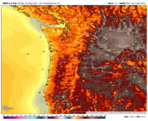
Areas along the West Coast will experience dry weather through the weekend, with temperatures averaging near normal to start the weekend, then shifting above normal toward the end of the weekend, with extreme heat possible, especially in interior areas.
Temperatures will soar into the upper 90s across western Washington, with some areas potentially reaching values close to 100. Image provided by WeatherBell.
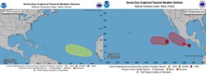
Looking at the week ahead, things are expected to remain relatively quiet. Areas across the Central U.S. will continue to see well below normal temperatures ahead of a slow moving warm front. Areas in the west, specifically in the Pacific Northwest, will continue to see above average temperatures, where hot temperatures are expected to continue through the remainder of the week. There are no active storms in either the Atlantic or the Pacific; however, some areas are being monitored for potential development as the week progresses.
Disturbances in the Atlantic and Pacific are being monitored over the next week, where environmental conditions could support the development of tropical systems. Images provided by the National Hurricane Center.
August typically brings a range of weather conditions to the United States, from excessive heat to tropical systems and everything in between. As we move into the middle of the month, we are beginning to see this play out.
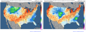
This weekend will bring dry and warm weather to much of the country. Many areas are expected to experience above-normal temperatures on Saturday. In contrast, others, including the Mid-Atlantic, Southeast, Intermountain West, and North-Central Rockies, are expected to experience below-normal temperatures. A cold front moving into the center of the country on Saturday will allow temperatures to dip below normal across the Central Plains on Sunday. Temperatures will also shift above normal on Sunday in interior areas of the Pacific Northwest as high pressure builds in across the region.
Temperatures average mainly above normal through the weekend across much of the country, with below normal temperatures in the Intermountain West, Southeast, and Mid-Atlantic. Images provided by Weathermodels.
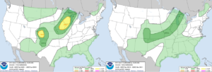
A cold front moving across the central United States will bring a marginal risk of severe weather to the Upper Great Lakes and Central Mississippi Valley, as well as the Central and Southern Plains, through the weekend. The highest risk for severe storms will be on Saturday, with a slight risk of severe weather across southwestern Wisconsin, southeastern Minnesota, northeastern Iowa, and eastern Colorado.
There is a slight risk of severe weather on Saturday for the Upper Midwest and eastern Colorado, with a marginal risk through the weekend from the Upper Midwest to the Southern Plains. Images provided by the Storm Prediction Center.
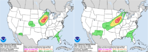
The cold front will also bring heavy rainfall to the Upper Midwest. There is a moderate risk of excessive rainfall across southwest Wisconsin, eastern Iowa, northwestern Illinois, and northeast Missouri on both Saturday and Sunday, with a slight risk extending from southern Wisconsin to eastern Kansas. A stationary front will continue to produce rain and thunderstorms across much of the Southeastern United States, with a marginal risk of excessive rainfall on both days. Meanwhile, in the Southwest, monsoonal moisture will bring showers and thunderstorms to the region with a marginal risk of excessive rainfall for both Saturday and Sunday.
The Upper Midwest will face the highest risk of excessive rainfall through the weekend, with areas such as the Southeast and Southwest also facing a marginal risk. Images provided by the Weather Prediction Center.
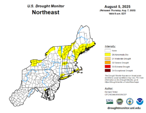
As we move into the beginning of next week, temperatures are expected to rise across the Northeast, with above-normal values anticipated for much of the week. The slow-moving front will bring showers and thunderstorms to the Midwest through the middle of the week before moving into the Northeast toward the second half of the week. The Northeast will see its next potential for rain as this front moves through, ending its dry stretch, which has caused some areas to become abnormally dry across the region.
Areas of the Northeast are becoming abnormally dry as the region continues to see dry conditions. Image provided by the National Drought Mitigation Center.
The stationary front across the south will continue to bring the potential for rain and thunderstorms to much of the region through the end of the week. Areas in the Southwest will also see the possibility of showers and thunderstorms each afternoon as monsoonal moisture remains over the region. Otherwise, high pressure will continue to bring dry weather to the majority of the country.
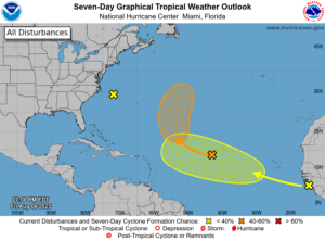
We will also be monitoring tropical development as the week progresses, since the National Hurricane Center continues to monitor areas in the Atlantic Ocean for possible development over the next seven days. Some models have been in favor of tropical development by the end of the week, but also show vastly different solutions for these systems. At this time, it is still too early to determine whether these storms will develop, never mind their storm tracks.
The National Hurricane Center is monitoring three areas for tropical development in the Atlantic over the next 7 days. Image provided by the National Hurricane Center.
Over the past few months, there has been consistent troughing over the United States, particularly in the Great Lakes region, which has led to a stormier pattern across the eastern half of the country. One factor that can influence these changes in storm patterns and consistency is teleconnections.
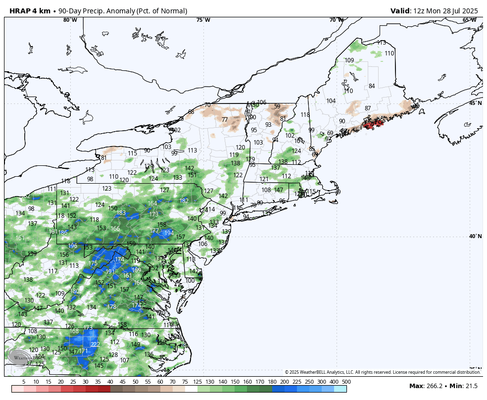
Above to well above normal rainfall has been common across the Northeast over the past 90 days. Image provided by WeatherBell.
Teleconnections are relationships between specific weather phenomena at locations often separated by considerable distances. These phenomena are correlated with particular climate patterns spanning thousands of miles and exhibit variabilities ranging from days to years. Some of these patterns can also have more significant impacts during specific seasons, while others affect the climate pattern throughout the year.
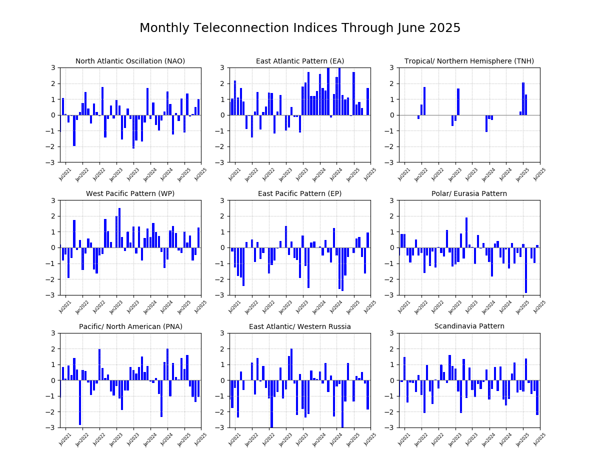
Many of the teleconnection patterns that affect the United Stated have been mostly positive since the start of the year. Image provided by the Climate Prediction Center.
Some of the major teleconnections and patterns that affect North America include the Arctic Oscillation (AO), El Niño/Southern Oscillation (ENSO), East Pacific Pattern (EP), North Atlantic Oscillation (NAO) , Pacific/North American Pattern (PNA), and Madden-Julian Oscillation (MJO). Patterns like ENSO will have a lesser impact on intraseasonal climate variability, as it can take several months to transition between phases. In contrast, the NAO will have a greater impact, as it can change between phases on a more regular basis.
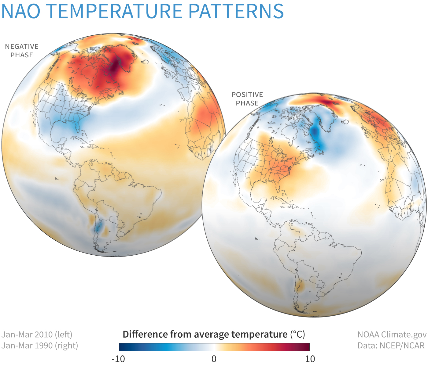
Temperature patterns for North America associated with the different phases of the North Atlantic Oscillation. Image provided by the Climate Prediction Center.
The NAO is an oscillation that impacts the climate pattern throughout the year. The positive phase will generally bring above-normal temperatures with a drier pattern to the Eastern United States, while the negative phase will produce the opposite. In the winter, a negative NAO usually leads to blocking over Greenland, and an increasing chance for more potent storms off the East Coast. The NAO has been mainly in the positive phase since early 2025. Although this may mean dry and warm conditions, the spring of 2025 averaged above normal for both temperature and precipitation across the eastern United States.
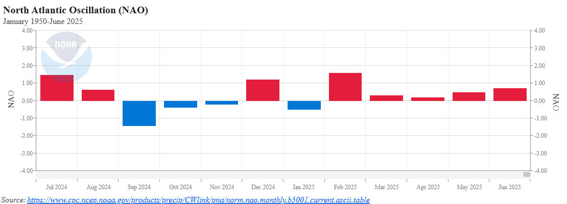
The monthly average of the NAO has been leaning positive since the beginning of 2025. Image provided by the National Center for Environmental Information
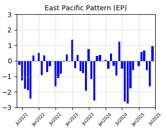
When examining other teleconnection patterns to identify the potential origins of the persistent unsettled pattern, it can be noted that the East Pacific Pattern transitioned into its positive phase in June, following a predominantly negative phase, especially over the past year. When the East Pacific Pattern is in its positive phase, the Eastern United States will experience more cyclonic activity, i.e., the persistent troughing we’ve been seeing across the Great Lakes and into the Eastern United States over the last several weeks.
The monthly average of the East Pacific Pattern shifted positive in June after leaning negative for the last year. Image provided by the Climate Prediction Center.
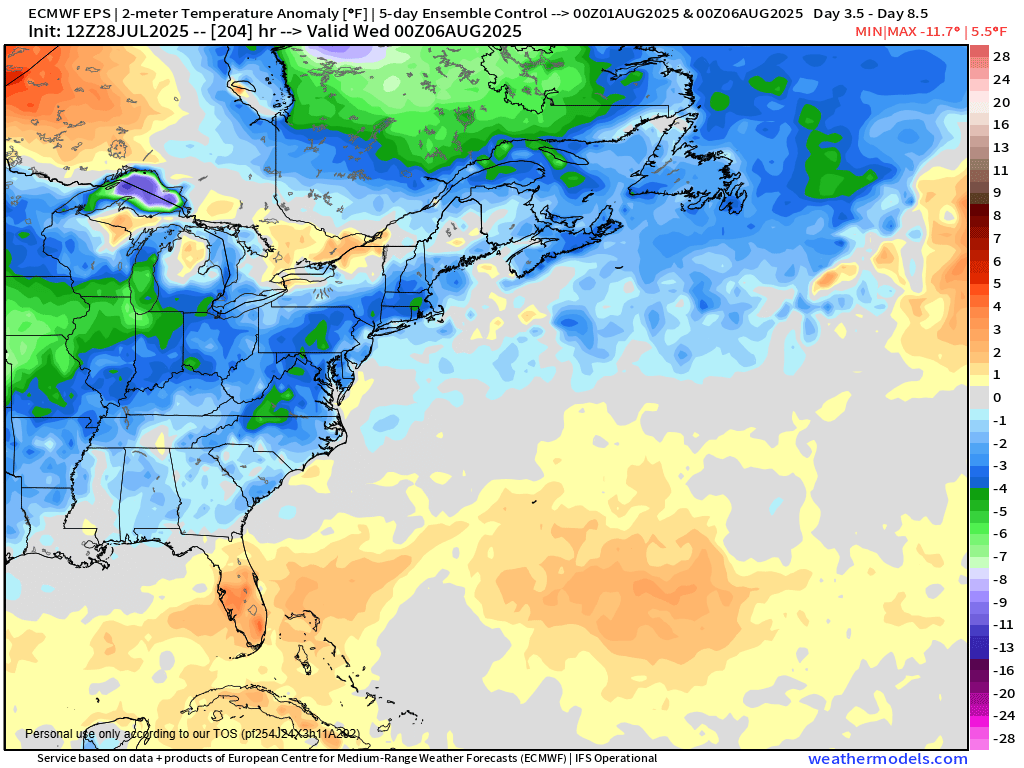
The stormy pattern is expected to continue across the East this weekend, as the NAO is expected to turn negative again, and a large trough of low pressure will settle into the Northeast. After a couple of hot and humid days for the first half of the week, a strong cold front will cross the region late Wednesday and Thursday before stalling out across the Mid-Atlantic states. Behind the front, temperatures will be as much as 5-10 degrees below normal for the end of the week and into the start of next week.
Much cooler weather will settle into the Eastern half of the nation this weekend. Image provided by Weathermodels.com.
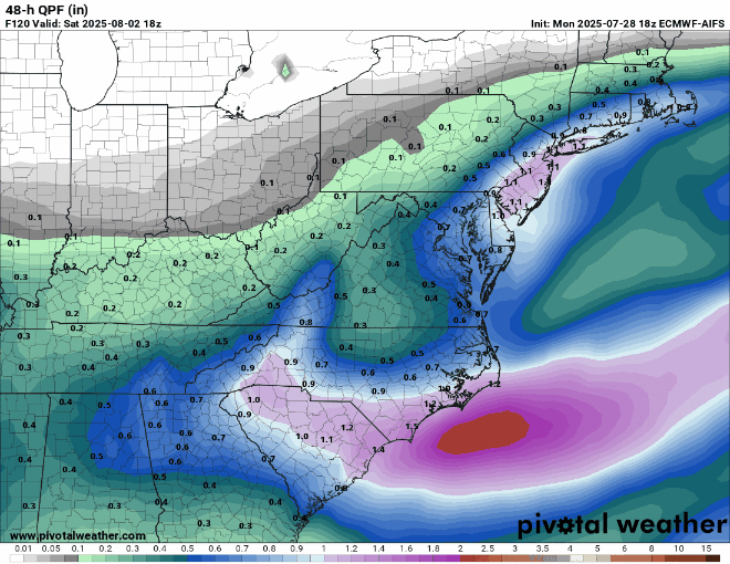
Along with the cooler weather, the potential exists for more heavy rain and flooding in parts of the Mid-Atlantic states and Northeast. As that front stalls out, a wave of low pressure will ride along it Thursday into Friday. With plenty of moisture in place in the tropical atmosphere south of the front, the wave of low pressure will produce heavy rain and thunderstorms. Some models show the potential for 3-6 inches or more of rainfall in spots in the span of 24-36 hours. Where the heaviest rain falls will be determined by where the front stalls out and the wave rides along it, which is still uncertain at this point.
Models are showing the potential for some heavy rain in the Northeast and Mid-Atlantic at the end of the week. Images provided by Pivotal Weather.
This pattern has the potential to produce other issues as we head deeper into the summer. The tropics have been mostly quiet thus far, but we’re approaching the time of year when activity ramps up. The bulk of storms in the Atlantic form between mid-August and mid-October. While many storms will end up recurving and heading out to sea before impacting the United States, an East Coast threat becomes a little more likely with an upper-level trough of low pressure in the Midwest or near the Appalachians.
As we begin the Independence Day holiday weekend, high pressure will bring dry weather to many areas of the eastern United States, while places out West could see unsettled weather. A frontal system will move east into the start of next week, bringing showers and thunderstorms across the northern and eastern half of the country. Hot and potentially dangerous temperatures are possible into the start of the week across the Midwest and Northeast. Eyes are on the waters off the Southeast, where tropical storm development is possible around mid-week.
Friday – Independence Day
A cold front that has recently crossed the Northeast will provide perfect weather for the region, high pressure bringing sunshine and lower dewpoints, keeping humidity at a very comfortable level. High pressure will continue to dominate from the Great Lakes to the Gulf Coast, bringing sunshine to most of the Eastern United States.
Much drier air will move into the Northeast for Friday. Image provided by Weathermodels.com
Other areas of the Southeast will see the potential for rain as a low pressure near Florida allows the rain to continue. Remnants of the very short-lived Tropical Storm Barry will also bring the chance for rain and thunderstorms to most of Texas.
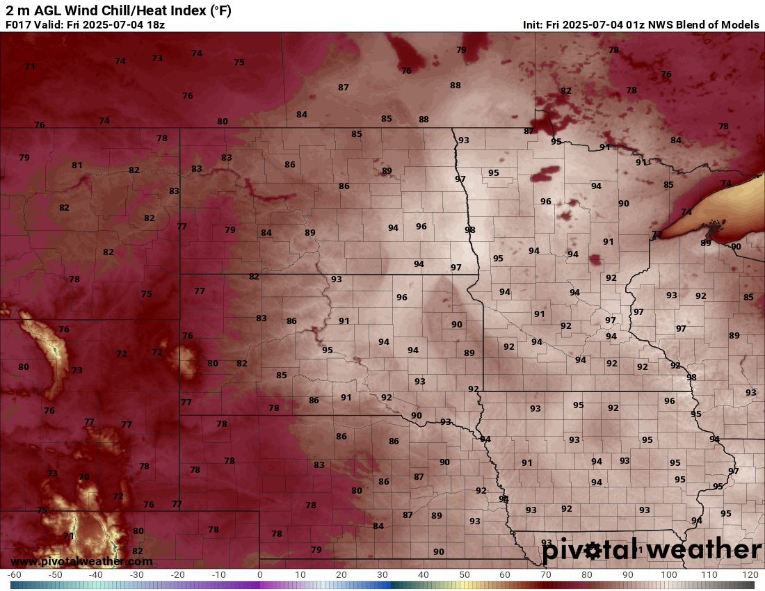
Hot and potentially dangerous temperatures are possible across the Upper Mississippi Valley and Northern Plains ahead of a cold front extending from a low pressure system in central Canada. This frontal system will bring rain and thunderstorms to the region, with a marginal risk of strong to severe thunderstorms.
Heat index Values for Friday across the Northern Plains. Image provided by Pivotal Weather.
Monsoonal moisture will produce showers and thunderstorms across parts of the Southwest, especially during the afternoon. A system in the Northwestern United States will bring showers with a chance of thunderstorms to the Pacific Northwest, Great Basin, and Intermountain West.
Saturday
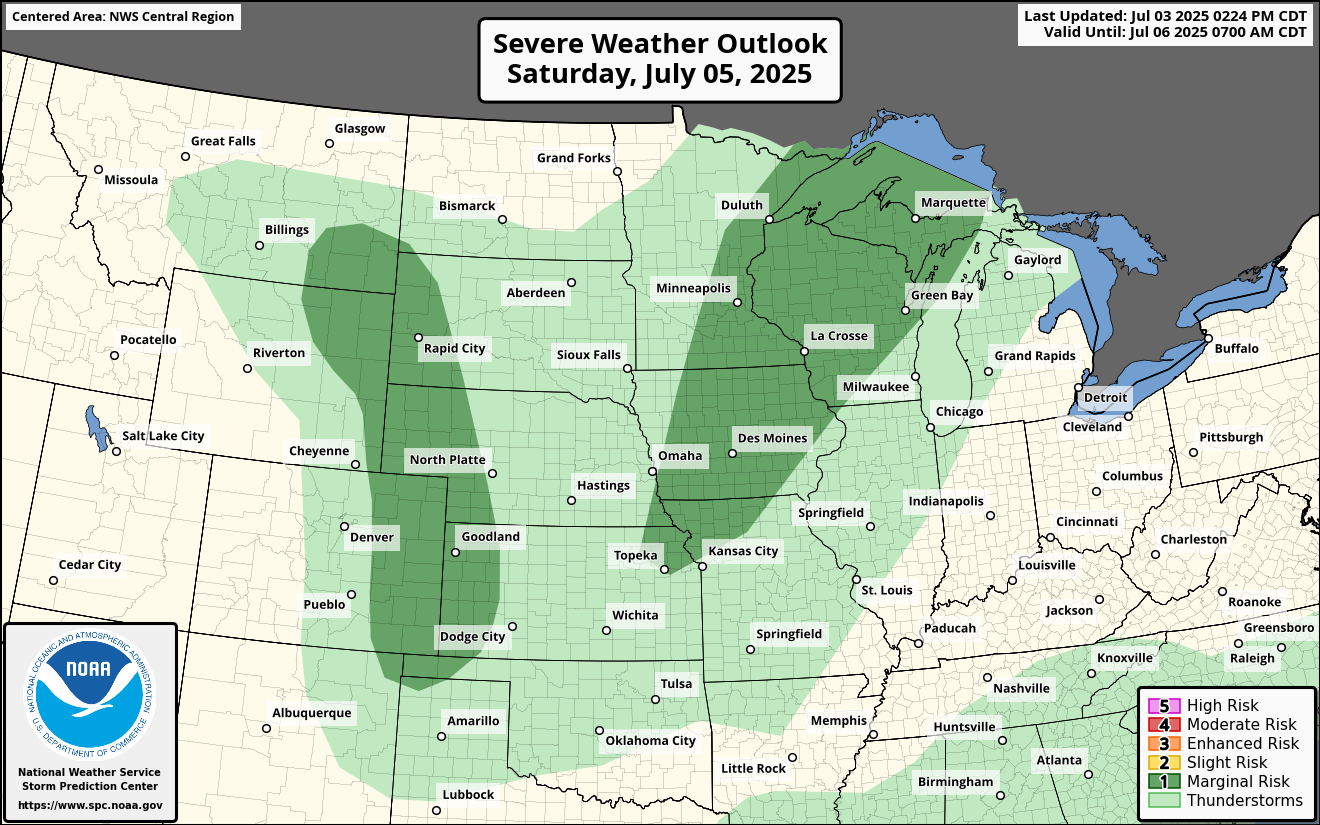
The hot temperatures will progress east as the frontal system moves across the northern United States, the marginal risk of severe weather continues across the Upper Great Lakes while also shifting to the central Mississippi Valley. The front will wrap up into the Central Plains as it converges with a weaker system in the Northwest, with a marginal risk of severe weather in the west-central Plains.
Severe weather outlook for Saturday. Image provided by the Storm Prediction Center.
The low pressure near Florida will bring another day of showers and thunderstorms to the state as moisture from Barry continues to sit over Texas, with more showers and thunderstorms possible.
Monsoonal moisture will allow the potential for afternoon showers and thunderstorms to return across the Southwest.
Sunday
Showers and thunderstorms will begin to taper off across Florida as the low pressure system nearby slowly pulls away from the region and moves up the East Coast, bringing shower and thunderstorm activity into the Mid-Atlantic.
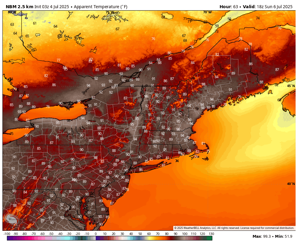
Hot and humid weather will return to the Northeast as the frontal system continues its eastward progression. Showers and thunderstorms are possible from the Great Lakes to the Southern Plains. The weaker system follows behind the main system, bringing the potential for showers and thunderstorms to the Central and Northern Plains.
Heat indices across the Northeast on Sunday. Image provided by WeatherBell.
Monsoonal moisture could potentially bring more showers and thunderstorms to the Southwest.
Monday through Friday
Hot and humid weather will continue across the Northeast on Monday as the frontal system continues its progression east with showers and thunderstorms possible from the Northeast to the Southern Plains. A weaker low pressure system following this system will continue to produce showers and thunderstorms through the Central Plains.
The low pressure system in the Southeast will continue its journey up the East Coast, allowing for the potential of showers and thunderstorms across the Mid-Atlantic. This system will begin to interact with the large frontal system on Tuesday, allowing the front to become stationary across the Tennessee Valley. The stationary front will produce showers and thunderstorms from the Ohio Valley to the Gulf Coast through the end of the week. These two systems will be monitored for tropical system development as they move offshore.
The East will be unsettled with the West turns drier next week. Loop provided by Pivotal Weather.
The smaller low pressure in the Central Plains will begin to weaken on Tuesday, allowing the shower and thunderstorm potential to diminish. Drier weather is expected through the middle of the week before another system develops toward the end of the week, bringing the potential for showers and thunderstorms.
Monsoon moisture will allow for the potential of afternoon showers and thunderstorms each afternoon.
Hot and humid conditions are expected across the eastern half of the nation as we go through the first weekend of summer.
A ridge of high pressure brings heat and humidity to the eastern half of the nation over the next few days. Loop provided by Pivotal Weather.
A large ridge of high pressure centered over the Mississippi and Tennessee Valleys Saturday morning will slowly move eastward over the next few days, resulting in hot and humid conditions for a large portion of the nation. The heat and humidity are focused on the Plains States and Mississippi Valley to start the weekend with Heat Advisories and Extreme Heat Warnings in place from the Northern and Central Plains into the Mississippi Valley and the Midwest. High temperatures will reach the 90s in much of this region, with highs topping 100 in parts of the Northern and Central Plains, possibly setting records in a few spots. With dewpoints in the upper 60s and 70s, the heat index will reach 100 to as high as 110 in much of the region. The heat will continue into Sunday, with widespread highs in the 90s and lower 100s expected once again and heat indices in excess of 100, but an approaching cold front will produce showers and thunderstorms during the afternoon and evening, some of which could be strong to severe, bringing relief to the region.
The heat index will top 100 across much of the nation’s mid-section Saturday afternoon. Image provided by WeatherBell.
The heat and humidity will shift into the Great Lakes and Northeast on Sunday, with record highs expected in many areas as temperatures rise well into the 90s. Dewpoints will be climbing into the 60s and 70s, resulting in heat indices near or over 100. Heat Advisories and Extreme Heat Watches and Warnings have been issued for much of this region. As we head into the start of the new week, the focus of the heat will shift once again to the heavily-populated Interstate 95 corridor along the East Coast. High temperatures in the upper 90s to possibly lower 100s are expected on Monday in this area likely setting records in dozens of locations, more likely on Tuesday. When the humidity is factored in, the heat index will reach 105 to 110 degrees in many areas. Little relief is expected at night, as nighttime lows only drop into the 70s, with some of the urban areas possibly staying above 80. A backdoor cold front may bring some relief to parts of New England, possibly as far south as the New York City area on Wednesday, but heat and humidity will continue across the Mid-Atlantic states.
Temperatures could approach 100 across much of the Northeast on Tuesday. Image provided by Weathermodels.com
While heat is making headlines across the eastern half of the nation, in the Northern Rockies, a late-season winter storm is moving in. A storm system moving in will bring strong winds and heavy precipitation to the region today and into Sunday. Sustained winds of 30-40 mph with gusts in excess of 60 mph are expected in some areas. Across the higher elevations of western Montana and eastern Idaho snow levels have fallen as low as 5000 feet. Above that level, snowfall totals of 4-8 inches are expected by Sunday morning, with totals of 10-20 inches expected once you get above 6000 feet. Winter Storm Warnings and Winter Weather Advisories have been issued for much of this region. The chilly weather won’t last long, as temperatures return to near to above normal levels across the region by Tuesday.
Heavy snow is expected across the higher elevations of Montana and Idaho this weekend. Image provided by Weathermodels.com
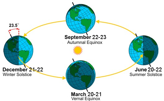
The summer solstice occurs at 10:41pm Friday, marking the official start of astronomical summer in the Northern Hemisphere. Summer weather will arrive along the East Coast just before that.
Astronomical summer begins Friday night. Image provided by the National Weather Service.
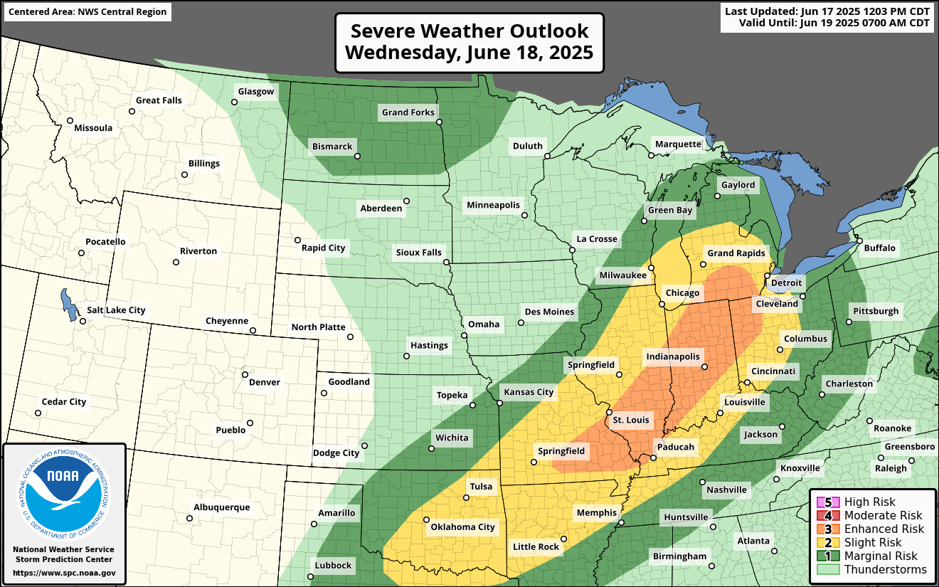
A frontal system extending from the Great Lakes into Southern Plains will slowly make its way eastward over the next few days. Ahead of the front, warm and humid air will result in an unstable atmosphere, with showers and thunderstorms developing. This front produced severe weather on Tuesday from the Front Range of the Rockies into the Central and Southern Plains, and severe thunderstorms will likely be more widespread on Wednesday from the Southern Plains into the Great Lakes. Some of the stronger storms may produce damaging winds, large hail, torrential downpours, and tornadoes, especially across parts of the Ohio Valley.
Severe weather is expected across a large swath of real estate from the Southern Plains to the Great Lakes on Wednesday. Image provided by the Storm Prediction Center.
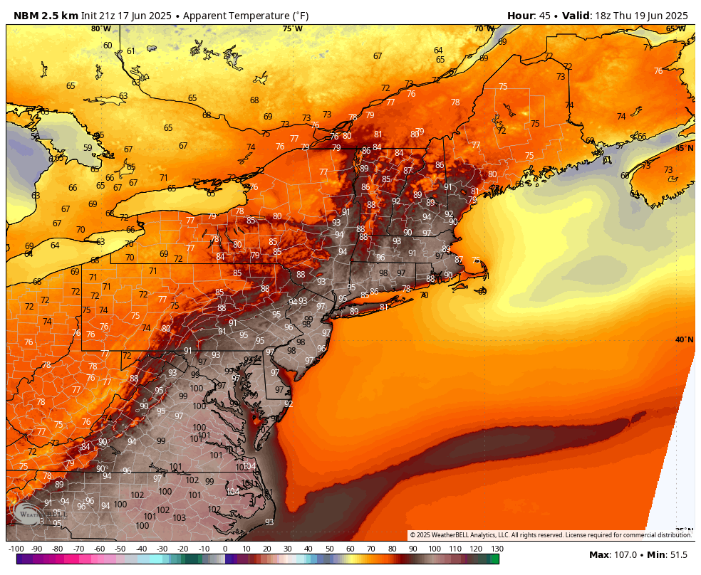
The front will continue marching eastward, heading toward the East Coast on Thursday. Ahead of the front, hot and humid weather is expected, especially along the heavily-populated I-95 corridor. For parts of the Northeast, especially from the New York City area into Southern New England, this could be the first time the mercury reaches 90 since August 28, 2024. For areas farther south, from Philadelphia into North Carolina, temperatures already reached or exceeded 90 at least once this year but could get into the middle 90s on Thursday. Accompanying the heat will be humid conditions, with dewpoints getting into the 70s for much of the region. This will result in heat indices in the middle to upper 90s for many areas, possibly over 100 from Washington southward to North Carolina.
The heat index will get well into 90s and lower 100s for much of the East Coast Thursday afternoon. Image provided by WeatherBell.
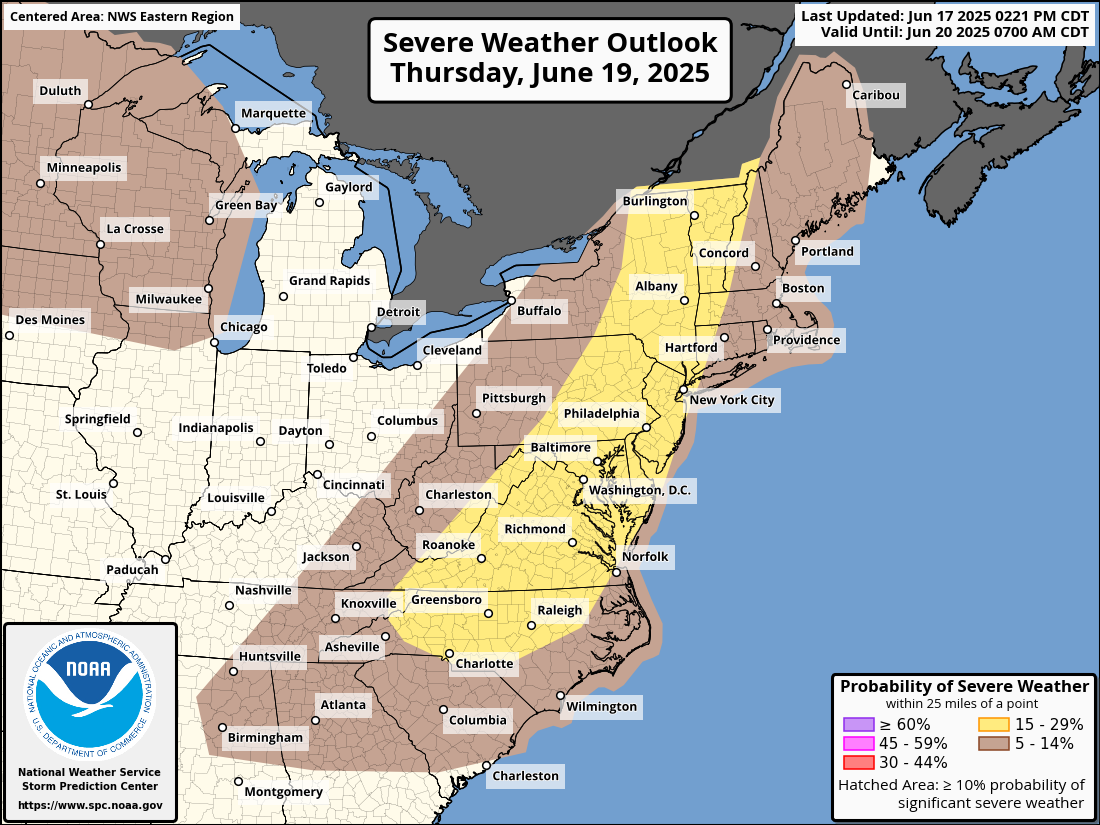
Luckily, the heat and humidity will be short-lived. The aforementioned cold front will move into the region during the afternoon and evening, producing more showers and thunderstorms, some of which could be strong to severe. The timing of the front will help determine where the strongest storms develop, but the main threats with any storms that do form are damaging winds, heavy downpours, and hail, with a few tornadoes possible.
Severe weather is possible on Thursday from parts of New England to the Carolinas. Image provided by the Storm Prediction Center
Drier weather settles into the East behind the front for Friday and Saturday, though temperatures will remain near to above normal. There’s a good chance that much of the Northeast will see its streak of 13 consecutive Saturdays with rainfall finally come to an end, but that is not guaranteed yet. Some models are showing the potential for a cluster of thunderstorms to develop in the Northern Plains Friday night, then race across the Northern Great Lakes and into parts of Northern New York and New England by Saturday night. Beyond that forecast models are showing the potential for a ridge of high pressure to settle into the East Coast for the first half of next week, resulting in an extended period of hot and humid weather.
A ridge of high pressure could bring another shot of heat and humidity to the East Coast early next week. Image provided by Pivotal Weather.