Astronomical spring begins next Sunday at 11:33am, and right on cue, severe weather season will start to ramp up across the southern tier of states.
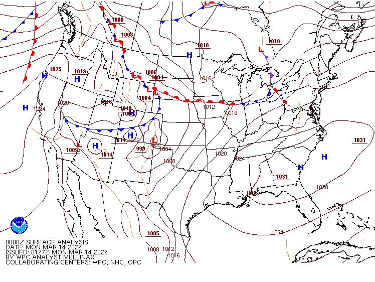
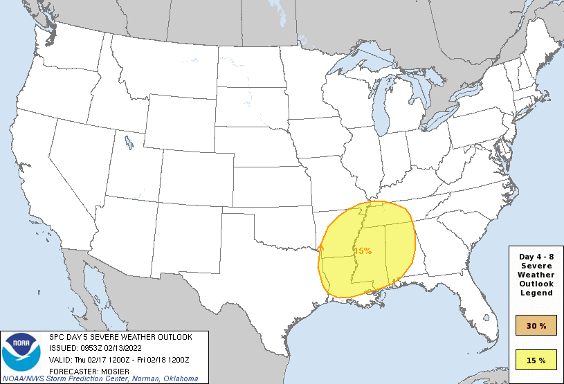
Low pressure moving into the Southern Plains will be the big story over the next few days. Image provided by NOAA.
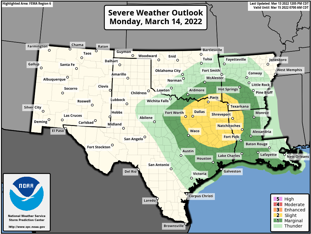
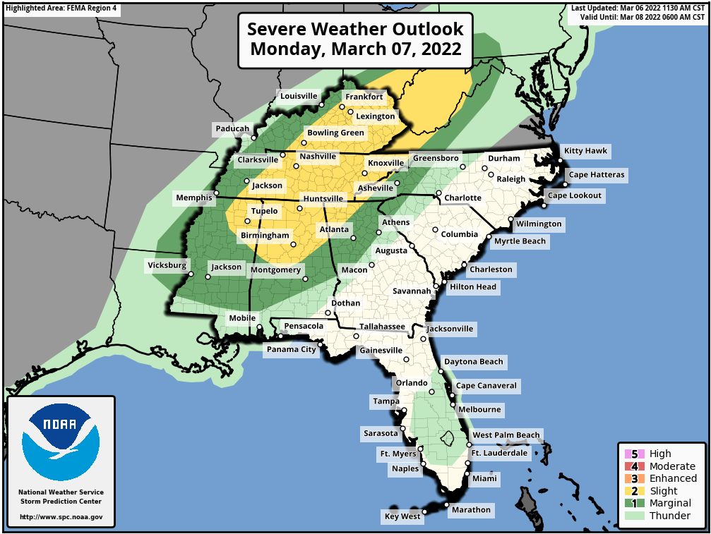
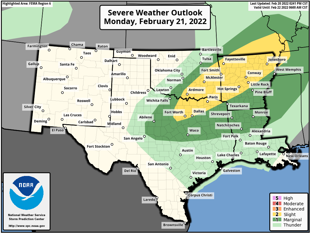
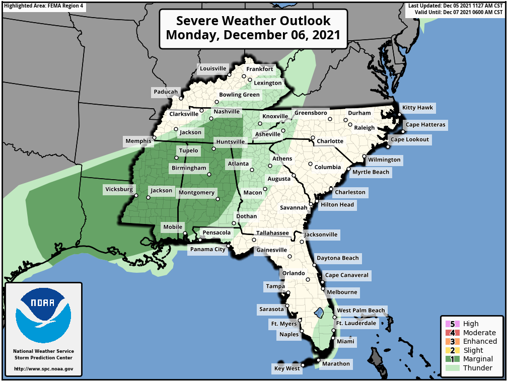
A low pressure system will move into the southern Plains and Texas on Monday, drawing warm and humid air northward from the Gulf of Mexico. This will help fuel some strong to severe thunderstorms during the afternoon and at night across portions of eastern Texas and into the Lower Mississippi Valley. Some of the stronger storms may produce large hail and damaging winds, with a few tornadoes possible, especially in parts of northeastern Texas. As the storm moves eastward. the severe weather threat will shift with it, spread into parts of the Gulf Coast and northern Florida on Tuesday, where damaging winds will be the main threat.
Severe weather is possible in parts of eastern Texas and the Lower Mississippi Valley on Monday. Image provided by the Storm Prediction Center.
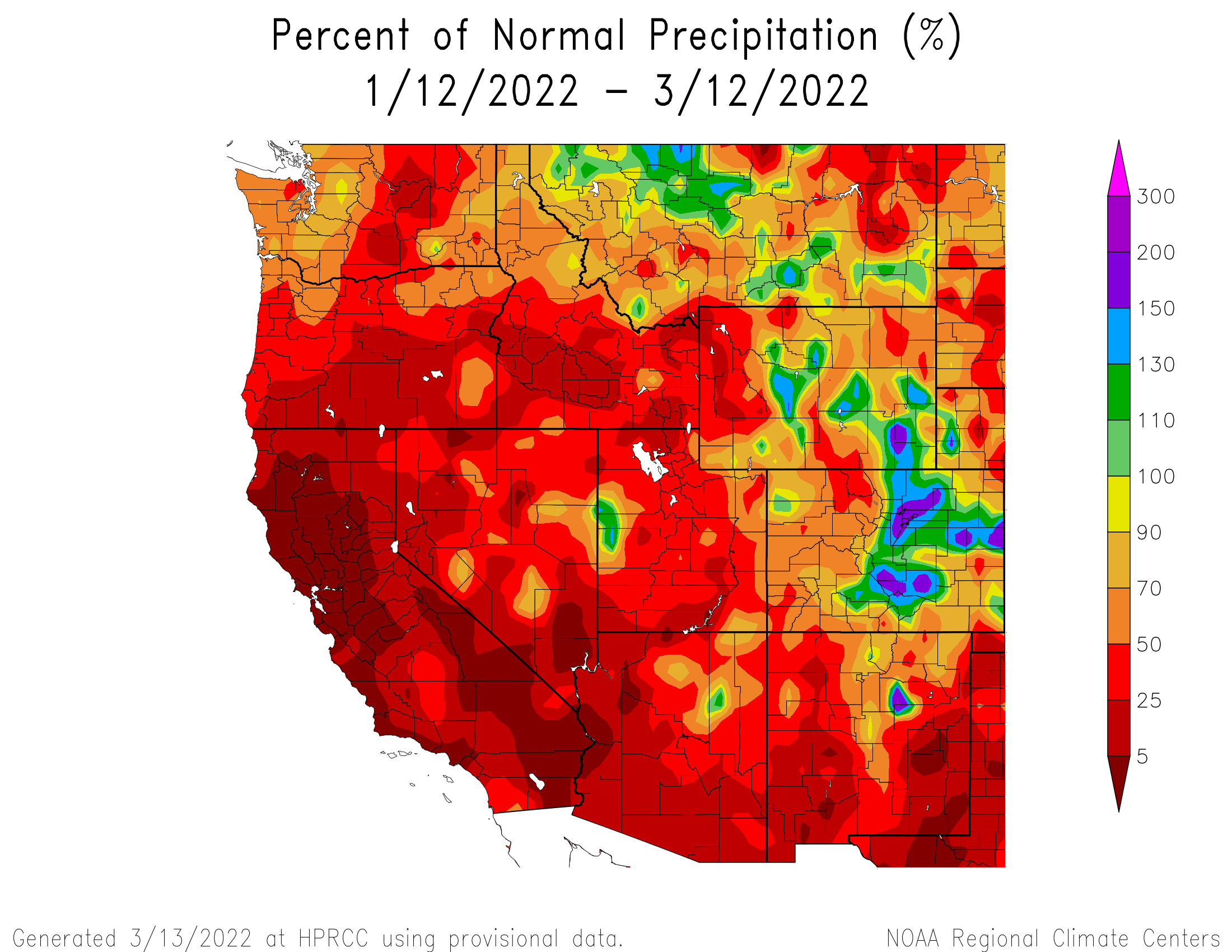
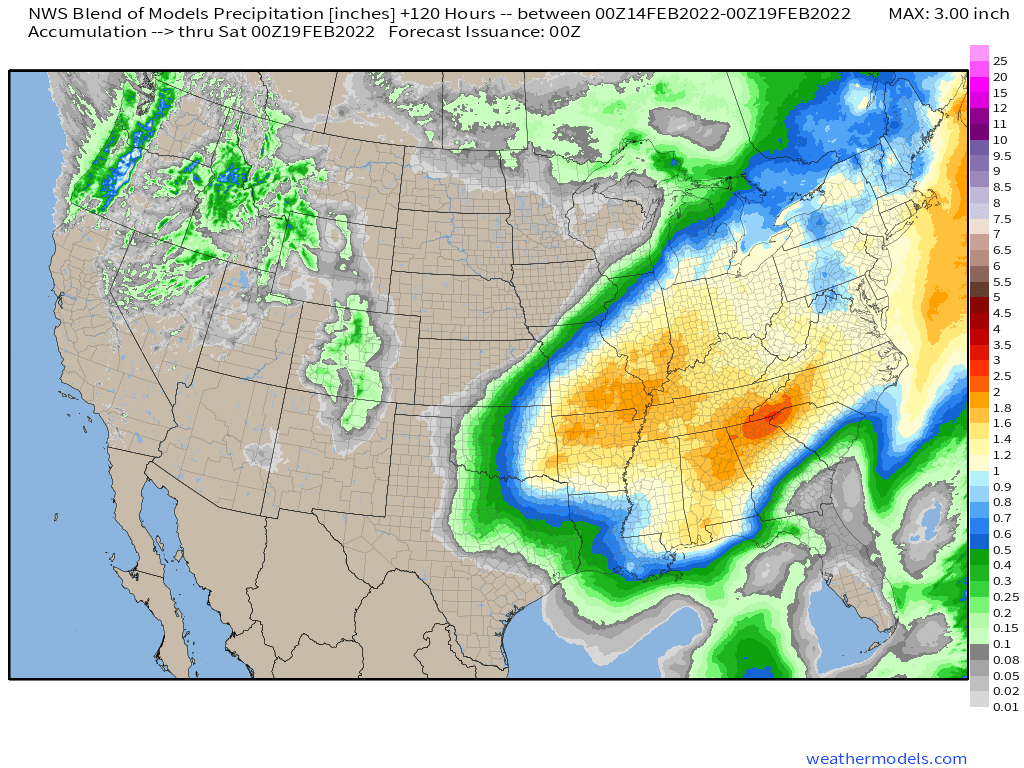
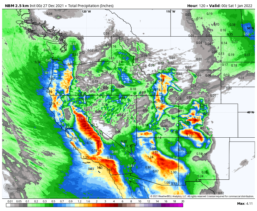
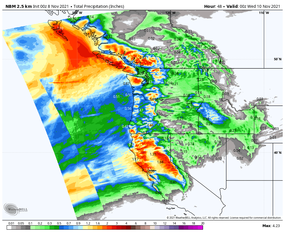
Out West, some much-needed rainfall will return later this week. After a very wet end to 2021, much drier weather has settled into the West Coast for the first 10 weeks of 2022, during what is normally the rainy season. A series of storms systems will move in this week, bringing some rain and mountain snow to parts of Washington, Oregon, and at least northern portions of California, as well as parts of Idaho and western Montana. Over the next seven days, many locations could receive 1-2 inches of rain, with significantly heavier amounts possible west of the Cascades and along the coast. Significant snow is possible in the mountains, especially the Cascades. None of these systems are expected to produce exceptionally strong winds, except perhaps right at the coastline.
Rainfall has been well below normal across most of the West over the past 60 days. Image provided by the High Plains Regional Climate Center.
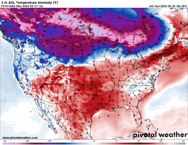
The other area we’re keeping an eye on stretches from the Northern Plains into the Northeast. Temperatures will be quite mild for much of the upcoming week. Temperatures will be 10 to 20 degrees above normal across much of the region through at least Thursday in the Plains, and Friday across the Great Lakes and Northeast. A few record highs are possible, especially toward the end of the week across the Northeast.
A rather active week is expected, especially across the eastern two-thirds of the nation.
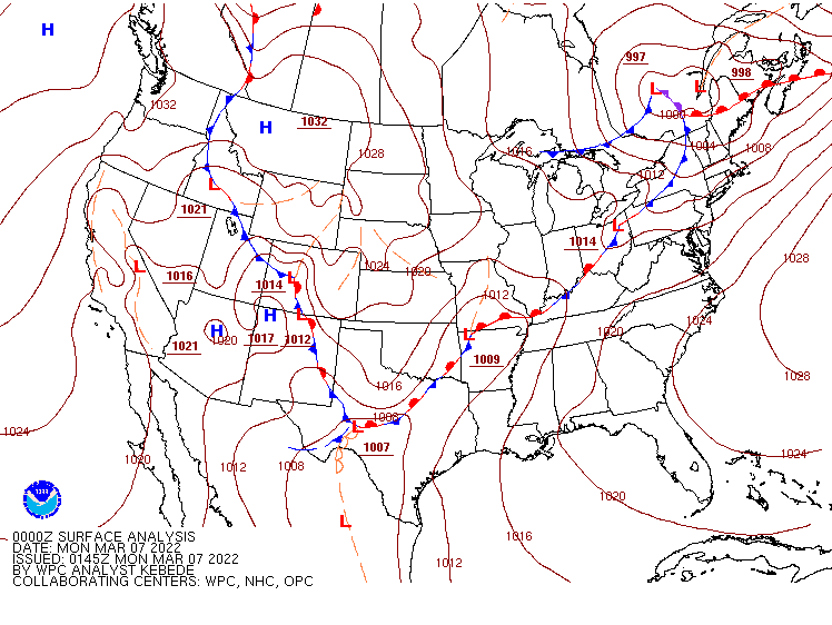
A wavy frontal system is draped across the nation to start the week. Image provided by NOAA.
Low pressure will move across the Ohio Valley and into the Northeast today, providing a variety of weather for the eastern half of the nation. The most impactful weather will be strong to severe thunderstorms, especially from the Deep South across the Tennessee Valley and into the Appalachians. Some of the storms may produce damaging winds, heavy downpours, and possibly tornadoes. In addition to the severe weather, heavy rain is expected across the Ohio Valley. Widespread rainfall totals of 1-2 inches and locally heavier are expected, resulting in Flood Watches being issued for much of the region.
Severe weather is possible today from the Tennessee Valley into the Appalachians. Image provided by the Storm Prediction Center,
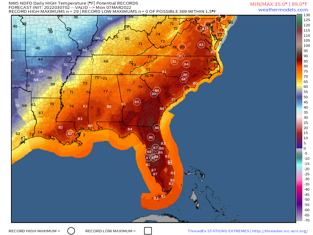
Ahead of the storm, unseasonably warm weather will remain in place today from the Gulf Coast into the Mid-Atlantic states and parts of the Northeast. High temperatures should reach 80 or higher from Washington, D.C. southward, with 70s into the Mid-Atlantic states. Dozens of record highs are expected to be set once again.
Dozens of record highs are likely across the East and South today. Image provided by Weathermodels.com.
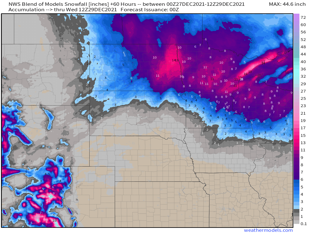
Later this week, another low pressure system is expected to develop across the West. It will bring a snowstorm to parts of the Rocky Mountains and into the Plains states. Snowfall totals of 4-8 inches will be widespread, with many locations, especially at the higher elevations, possibly seeing more than a foot. Snowfall has been below normal across the region this year, and parts of the region rely on the snowmelt for water in the spring/summer, so any snow that falls now is welcome.
Moderate to heavy snow may fall across the Rockies later this weekend. Image provided by WeatherBell.
Once it moves away from the Rockies, that system could become a rather potent storm system as it heads eastward. Ahead of the system, heavy rain and possibly more severe weather may impact parts of the Gulf Coast, Deep South, and Southeast towards the end of the week and into the weekend, with heavy snow possible north and west of the system from the Plains states into the Great Lakes and parts of the Northeast. There are some indications that it could become rather strong as it moves into the Northeast, with the potential for strong winds across much of the East Coast. This will be something to keep an eye on later this week.
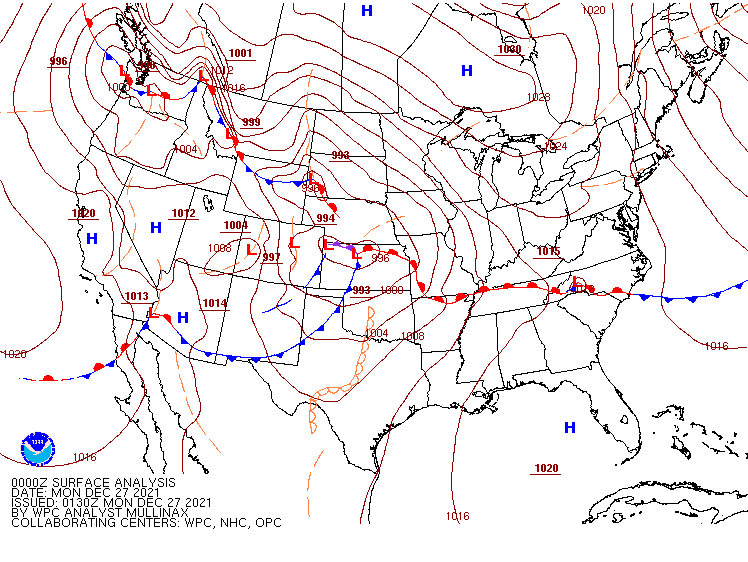
A rather active pattern is expected across the nation during the upcoming week.
The surface analysis doesn’t look busy to start the week, but the pattern will be quite active. Image provided by NOAA.
Low pressure will move into the southern Plains today, heading toward the Great Lakes on Tuesday, then up the St. Lawrence Valley Tuesday night, producing a variety of weather across the eastern two thirds of the nation. As it draws warm and humid air northward from the Gulf of Mexico, it will produce some heavy rain and thunderstorms, some of which could be strong to severe, across parts of southern Plains and Mississippi Valley today and tonight, with the heavy rain and severe weather threat shifting into Deep South and Tennessee Valley on Tuesday. Many areas could see 1-2 inches of rain, with heavier amounts possible, which could lead to flooding in some areas. Unseasonably mild weather is also likely ahead of the storm, with some record highs possible in the Mississippi Valley on Tuesday and parts of the Southeast on Wednesday. A few record highs are also possible in the Northeast during Tuesday and Wednesday and warmer air surges northward ahead of the system.
Severe weather is possible from the Southern Plains into the Mississippi Valley on Monday. Image provided by the Storm Prediction Center
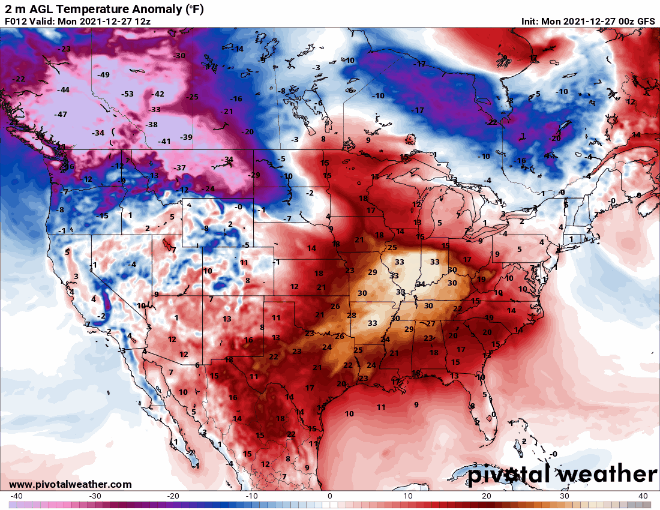
To the north, the storm will produce heavy snow and gusty winds, resulting in near-blizzard conditions at times from the Northern Plains into the Great Lakes over the next couple of days. Snowfall totals of 5-10 inches are possible in parts of the Dakotas today into Tuesday, but in the Great Lakes, many areas could see a foot or more. Once the snow ends, arctic air will settle into the region. Temperatures will drop below zero each night this week across most of the Northern and Central Plains and the Upper Midwest, with record lows possible in many locations. Temperatures will be 20 to 40 degrees below normal through Wednesday before some moderation begins.
Very cold air settles into the Plains States and Midwest over the next several days while warm air moves into parts of the East and South. Loop provided by Pivotal Weather.
Later in the week, we’ll do it all over again. Low pressure will move out of the Southern Plains and toward the Ohio Valley on Thursday, before redeveloping off the Mid-Atlantic coastline. Ahead of the storm, some heavy rain and thunderstorms are likely from the Lower Mississippi Valley into the Deep South and the Mid-Atlantic states, with more record highs possible across parts of the Southeast. The difference this time is with a track farther to the south compared to the early-week storm, the threat for wintry weather will increase from the Ohio Valley into the Northeast. The exact track will determine what areas get all snow and what areas see a mix of snow, sleet, and/or freezing rain, but areas that remain all snow have the potential for 6 or more inches of accumulation.
Another storm will bring a variety of weather to the eastern half of the nation later this week. Loop provided by Tropical Tidbits.
While the pattern will remain quiet for much of the nation to start the week, a significant storm may impact a large portion of the nation later this week with a variety of weather.
A wavy frontal system extends across much of the nation to start the week. Image provided by NOAA.
A low pressure system will bring some rain and higher elevation snow to parts of the Pacific Northwest and the Great Basin over the next day or two, but its biggest impacts will be felt later this week. as it moves into the nation’s mid-section on Wednesday, it will start to draw warm and humid air northward from the Gulf of Mexico. At the same time, a large high pressure area will bring colder air into the Northern Plains. As these airmasses clash, we could see some strong to severe thunderstorms developing ahead of the system. Severe storms are possible across parts of the Southern Plains and Texas late Wednesday, with the severe weather threat shifting into the Mississippi and Tennessee Valleys on Thursday, reaching the Deep South and the Southeast by Thursday night.
Severe weather is possible across parts of the Mississippi Valley and Deep South on Thursday. Image provided by the Storm Prediction Center.
To the north of the storm, a narrow strip of heavy snow is possible from eastern Kansas into the Great Lakes, possibly including the Chicago area. Many locations in this region could see 6 or more inches of snow from storm. Ahead of the storm, heavy rain is likely across the eastern half of the nation during Thursday and Friday. Rainfall totals of 1-2 inches and locally heavier are likely from the Mississippi Valley to the East Coast, with some heavier amounts possible.
Heavy rain is possible across a large portion of the nation later this week. Image provided by Weathermodels.com
In addition to the heavy precipitation, unseasonably warm air is expected ahead of the storm. Temperatures will be 10-20 degrees above normal on Wednesday from the Southern Plains into the Ohio Valley. By Thursday, the warm air shifts to the East Coast, with temperatures likely to be 15-25 degrees above normal from the Southeast and the Ohio Valley into New England, where a few record highs are possible.
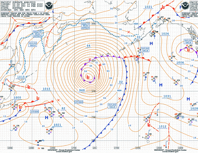
A powerful storm system is moving across the Central Pacific Ocean, heading toward Alaska. Image provided by the Ocean Prediction Center.
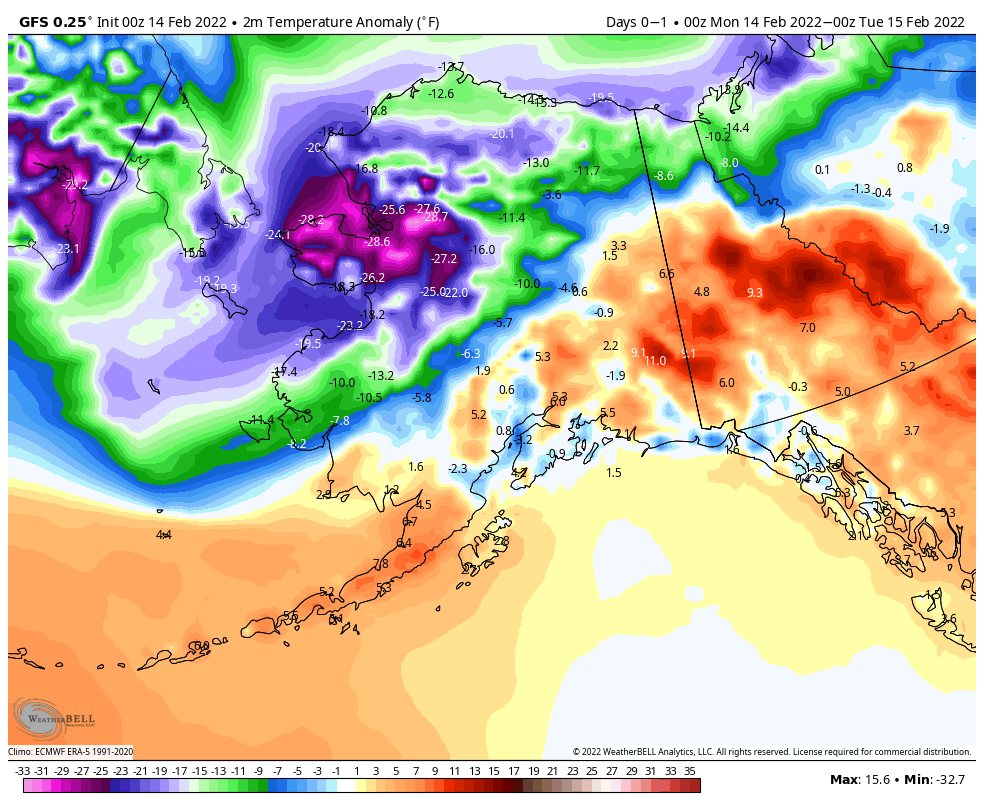
Meanwhile, up in Alaska, bitterly cold air remains locked in place across the northern half of the state. Temperatures will be 15-30 degrees below normal over the next couple of days. Wind Chill Warnings are in effect along the North Slope and the Arctic Coast, where wind chills of 40-70 below zero are possible today and Tuesday. However, changes are coming. A powerful Pacific storm will approach the state, and although it won’t be as strong as it currently is, it’s main impact will be to dislodge the cold air, and result in a significant temperature rise across the state. By the end of the week, temperatures could be 5-10 degrees or more above normal across a large portion of Alaska.
A significant moderation in temperature is expected across Alaska this week. Loop provided by WeatherBell.
A rather active week is expected across the nation, with heavy rain and snow in the West and the Rockies, record heat and potentially severe weather in the South, and heavy snow and bitterly cold temperatures for the Northern Plains.
A frontal system extended from coast to coast separates unseasonably warm air to the south from colder air to the north. Image provided by NOAA.
Low pressure will move across the Northern Plains and into southern Canada today, with heavy snow across the Dakotas and into Minnesota as well as parts of Manitoba and Ontario. Winter Storm Warnings are in effect on the US side of the border, with Snowfall Warnings on the Canadian side. Snowfall won’t be exceptionally heavy, but many locations will pick up 6-12 inches. gusts of 35-45 mph are possible, which may result in near-blizzard conditions at times. Snow should wind down tonight, but another system passing south of the region on Tuesday may bring more snow into the region.
Moderate to heavy snow is likely over the next few days in the Dakotas and parts of the Upper Midwest. Image provided by Weathermodels.com
Later in the week, bitterly cold air will drop southward from Canada into parts of the Northern Plains and Northern Rockies, as well as the interior Northwest. Temperatures will be 15 to 25 degrees below normal across the interior Northwest, and as much as 20 to 40 degrees below normal in parts of Montana, the Dakotas, and northern Minnesota. Daytime highs will likely stay below zero for several days near the Canadian border, with low temperatures as low as 20 to 30 degrees below zero in parts of Montana and North Dakota.
The GFS shows the clash between bitterly cold air to the north and unseasonably warm air to the south right through the week. Loop provided by Pivotal Weather.
While bitterly cold air settles into the North, unseasonably warm weather is expected across the South. High temperatures will reach the 70s and 80s from Texas to the Southeast over the next several days, which is 20 to 30 degrees above normal. Dozens of record highs are likely to be set across the region.
Low pressure will move into the Mississippi Valley by mid-week. With a warm, humid airmass in place, showers and thunderstorms are likely ahead of the system. Conditions could be ripe for some severe weather Wednesday into early Thursday, especially in parts of Louisiana, Alabama, and Mississippi.
Severe weather is possible across parts of the Lower Mississippi Valley and Deep South on Wednesday. Image provided by NOAA.
Meanwhile, out West, heavy rain and snow will continue across the region. With colder air in place, snow was observed right to the coastline in parts of Washington and Oregon on Sunday. The Seattle metropolitan area received 3-6 inches of snow, with 1-2 inches in the Portland area. As the low pressure area that produced the snow moves inland, more snow is likely, especially in the Cascades and Sierra Nevada, with rain into the lower elevations of California. Another system will follow right behind, with more heavy rain and mountain snow for the West Coast later this week. Rainfall totals of 1-3 inches and locally heavier will result in flooding in some areas, especially Southern California. Across the Sierra Nevada, snowfall totals of 3 to 6 feet are possible.
Heavy rain is expected across the West this week. Image provided by WeatherBell.
Right now, First Night festivities in New York City shouldn’t have any weather problems. In fact, it looks rather nice for revelers heading to Times Square to watch the ball drop. Right now, it looks like skies will be partly cloudy with temperatures around 40 degrees at midnight Friday night.
Stormy weather will return to the West Coast over the next few days, and could spread into the Northern Plains later this week.
Low pressure is bringing unsettled weather to parts of the West. Image provided by NOAA.
A low pressure system will bring heavy rain, gusty winds, and mountain snow to much of the West over the next few days, with a second system following for Tuesday into Wednesday. It has been relatively dry across the region recently, so the rainfall is welcome, but amounts could be excessive in spots. Rainfall totals of 1-2 inches will be fairly widespread, but some locations, especially along the California coast, could see upwards of 3-5 inches of rain. Flood Watches are in effect for parts of the Golden State. The rain will be accompanied by strong winds, which will be widespread not only along the West Coast, but well inland into the Great Basin and parts of the Southwest. Wind gusts of 30-50 mph will be common, with Wind Advisories in effect for many locations. The storm will also produce heavy snowfall across the mountains of the West, especially the Sierra Nevada, where snowfall totals of 2-4 feet or more are expected.
Heavy rainfall is likely across much of the West over the next few days. Image provided by Weathermodels.com
By mid-week, the storm will redevelop east of the Rockies, and head northeastward across the Plains States toward the Upper Midwest. It may produce some light to moderate snow from the Central and Northern Plains into the Upper Midwest, but the bigger story will be the strong winds it generates across the Plains States and into the Mississippi Valley. The potential exists for widespread wind gusts of 50-70 mph or stronger. In the Northern Plains, when you combine the winds with the snowfall, blizzard conditions are possible in parts of the Dakotas and Minnesota Wednesday into Thursday. The system may also generate more severe weather ahead of it from the Mississippi Valley into the Ohio and Tennessee Valleys later Wednesday into Thursday.
Strong winds are possible across much of the nation’s midsection Wednesday into Thursday. Image provided by WeatherBell.
The other big story will be the temperatures on either side of this storm system. Unseasonably mild weather is already in place across much of the nation today, but that’s just a taste of what is coming. On Tuesday, temperatures will be 15-25 degrees above normal across most of the Plains States and the Mississippi Valley, with some records possible. Wednesday looks to be the warmest day in this region, with dozens of records expected. Temperatures will be well into the 60s and 70s, which is 15 to as much as 35-degrees above normal. The warm weather will shift into the eastern third of the nation for the latter half of the week, where temperatures will be 15-25 degrees above normal.
Dozens of record highs are likely across the Central US on Wednesday. Image provided by WeatherBell.
Behind the system, much cooler weather will settle into the West for Tuesday and Wednesday, with temperatures dropping to 8 to 15 degrees below normal. The cooler air will shift into the Northern Plains by Thursday, and across the rest of the Plains for the end of the week, with temperatures running as much as 10 to 20 degrees below normal.
The weather pattern is fairly active across the nation right now, and there are several areas we’re keeping an eye on.
The pattern has become very active over the past several days across the nation. Image provided by NOAA.
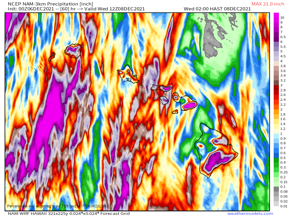
We’ll start off in the Pacific, where a low pressure system will bring a wide variety of impacts to the Hawaiian Islands today and tomorrow. Heavy rain will lead to widespread flooding across the islands, with strong winds also creating damage. Rainfall totals of 3-6 inches and locally heavier are expected through Wednesday. Flood Watches are in effect for much of the region. High Wind Warnings and Wind Advisories are also in effect, for sustained winds of 20-40 mph, with gusts of 50 to 60 mph possible. Along west-facing shorelines, waves of 8 to 12 feet will batter the beaches, where High Surf Advisories are in effect. If that wasn’t enough, across the higher summits of the Big Island, a Blizzard Warning remains in effect. Heavy snow will continue this morning with several more inches of accumulation possible. The snow will be accompanied by winds gusting as high as 80 mph, resulting in blizzard conditions.
Very heavy rain is likely across the Hawaiian Islands for the next few days. Image provided by weathermodels.com
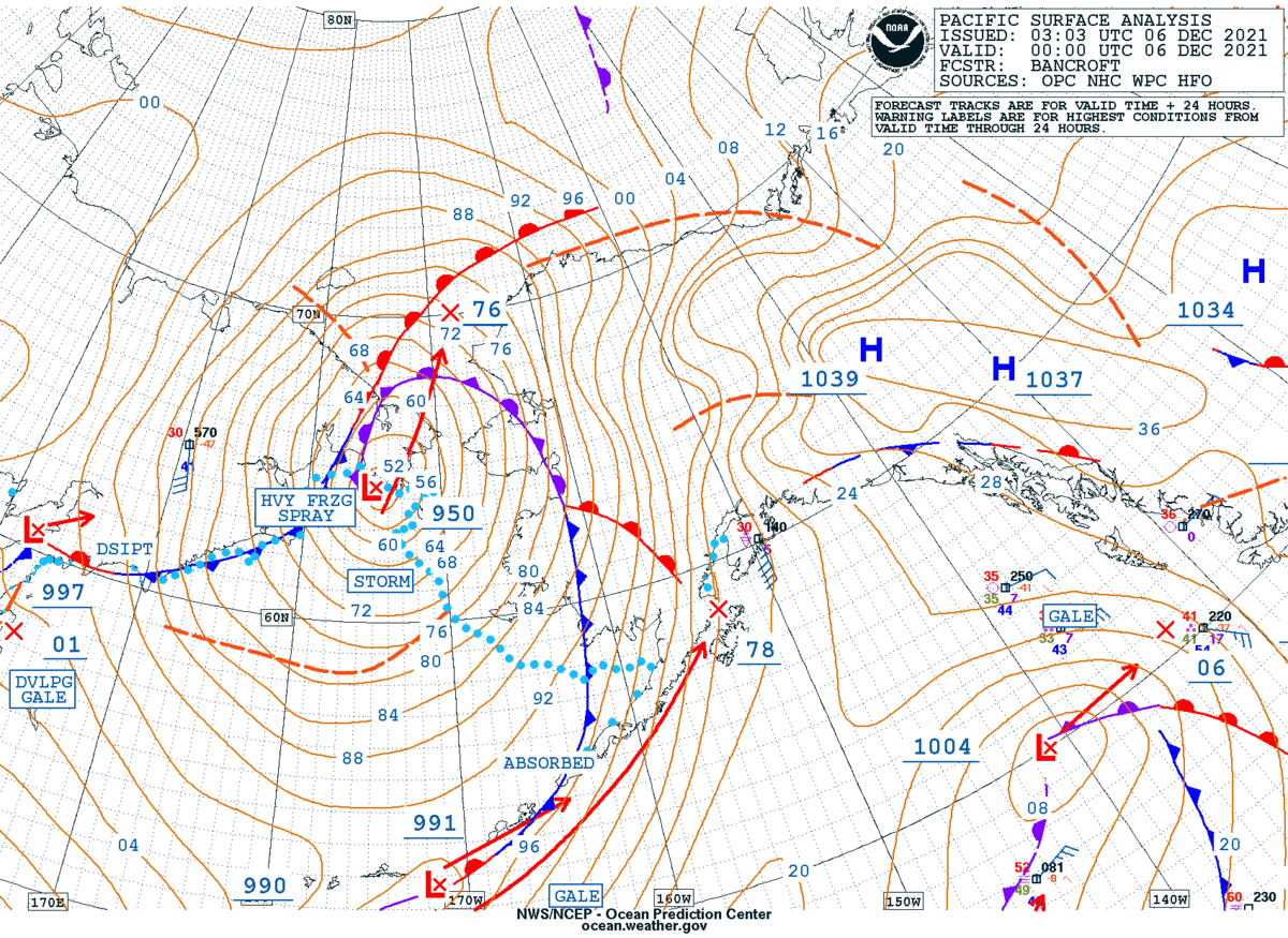
Next, we’ll stay in the Pacific, but head northward to Alaska. A strong low pressure system is sitting just west of the the state early this morning, and it is having a significant impact on the region. Blizzard warnings are in effect for parts of western and southern Alaska. Heavy snow will be accompanied by winds gusting as high as 70 mph. The strong winds, combined with astronomically high tides, will result in flooding along the coast as well. Heavy snow is also likely for many locations, with up to 8-16 inches for many areas, and even more in some spots. Across the higher elevations, several feet of snow are expected. The only positive to this is that the brutally cold weather that much of the state experienced in November has been replaced by temperatures that are well above normal, though bitterly cold air will likely return behind this storm system.
A powerful storm system will impact Alaska over the next few days. Image provided by NOAA.
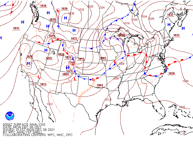
Across the Lower 48 States, the low pressure system moving into the Mississippi Valley this morning will garner the most attention today. It produced heavy snow in the Northern Plains and severe weather in the Mississippi Valley on Sunday. It will move into southern Canada today, dragging a strong cold front eastward. Ahead of the front, unseasonably mild air is expected across the East Coast, with temperatures topping 60 as far north as New England, and 70s into the Mid-Atlantic states. The warmth will be accompanied by some showers and gusty winds. Wind advisories are in effect for parts of the Northeast. Along the Gulf Coast and into the Lower Mississippi Valley, some strong to severe thunderstorms are possible ahead of the cold front. Some of the storms may produce strong winds, hail, heavy downpours, and possibly a few tornadoes.
Severe weather is possible in parts of the Lower Mississippi Valley today. Image provided by the Storm Prediction Center.
Another system will quickly follow for the Mid-Atlantic and Northeast on Wednesday. There’s quite a bit of uncertainty with the evolution of this second storm, but it has the potential to bring the first accumulating snow of the season to the I-95 corridor. While heavy snow seems unlikely at this point, some light to perhaps moderate accumulations are possible, which would result in travel issues for the heavily-populated region.
There is not a lot of agreement among the forecast models on what impacts the midweek storm will have and where they will be. Images provided by Pivotal Weather.
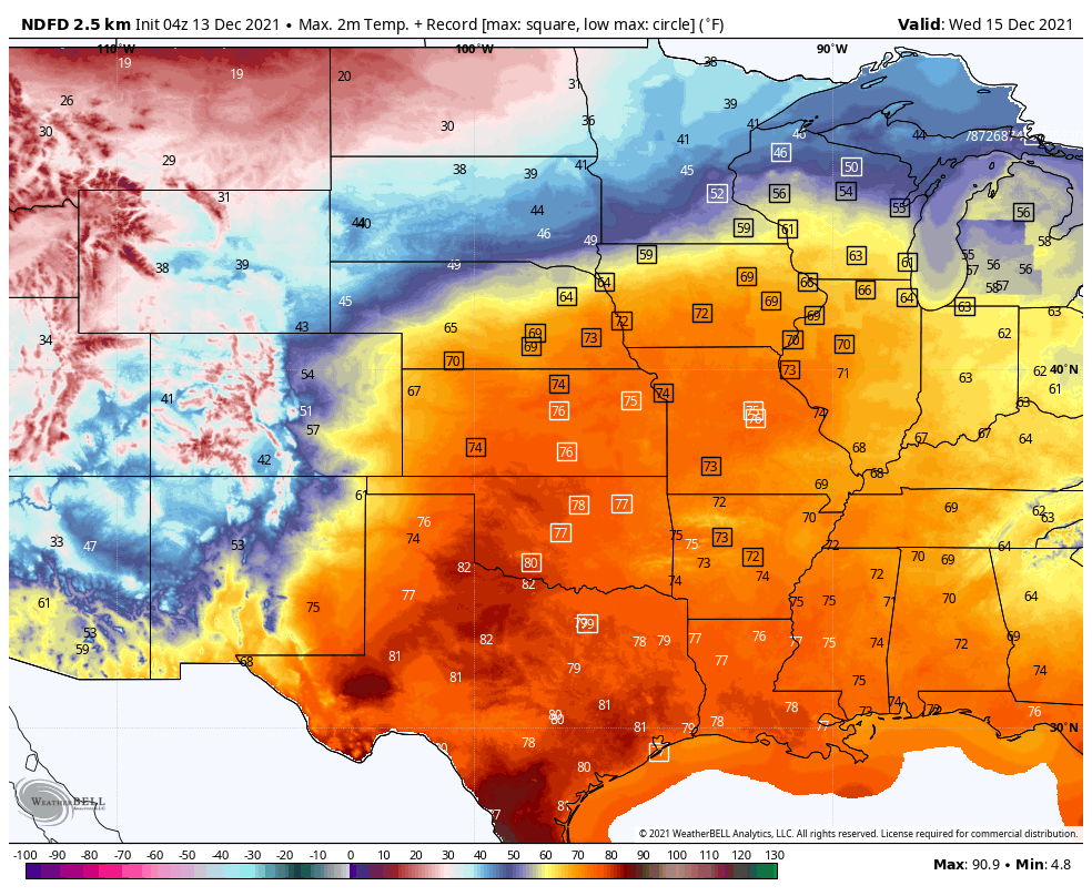
The other area we’re watching is the Southern Plains and Texas. After some record warmth over the past several days, cooler weather will settle in today and into Tuesday. However, another big warmup is expected later this week. Some record high temperatures are possible across the region on Thursday, but Friday looks to be the warmest day, with numerous records likely to be broken as highs soar well into the 70s and 80s, with 90s possible in southern Texas.
Numerous record high temperatures are in jeopardy by Friday as very warm air settles into the Southern Plains and Gulf Coast. Image provided by Weathermodels.com
On the flip side, very chilly air will settle into the Dakotas and Minnesota today in the wake of yesterday’s snowstorm. High temperatures will only reach the single numbers for parts of the region today, with some locations possibly staying below zero all day. Temperatures should start to moderate by tomorrow across the area.
A low pressure system moving into the West Coast today will impact the weather across much of the nation during the upcoming week.
The low pressure system currently in the Gulf of Alaska will be the big weather-maker this week. Image provided by NOAA.
Low pressure will move out of the Pacific and into the West Coast over the next day or two, spreading rain, some of it heavy, into the Pacific Northwest as well as northern and central portions of California. While this storm will be nowhere near the magnitude of some of the storms they’ve already seen this year, rainfall totals of 1-2 inches and locally heavier in some areas may result in localized flooding. The rian will be accompanied by gusty winds. Wind Advisories and High Wind Warnings have been issued for parts of the region. Wind gusts of 40-50 mph will be common, possibly resulting in damage and power outages in some areas. Across the higher elevations of the Cascades and the Sierra Nevada, heavy snow is likely, with many areas receiving more than a foot by the time everything winds down later Tuesday.
Heavy rain is expected across parts of the Northwest and California over the next day or two. Image provided by WeatherBell.
This system will weaken a bit as it moves into the Rockies by midweek, where several inches of snow is still expected. By Thursday, the system will intensify again as it moves into the Plains states. As it draws in some moisture from the Gulf of Mexico, it could produce some severe weather across parts of the Central and Southern Plains and into the Mississippi Valley ;ater Wednesday and Thursday. To the north, it will likely produce the first snowstorm of the season across the Dakotas and into parts of Minnesota late this week. Snowfall totals of 3-6 inches will be possible in parts of the region.
Several inches of snow may fall in parts of the Dakotas and Minnesota late this week. Image provided by Weathermodels.com
By the end of the week, the low pressure system will stall out near the Great Lakes, but ahead of it, a frontal system will draw moisture northward, bringing a period of heavy rain from the Tennessee and Ohio Valleys into the Mid-Atlantic states and the Northeast from Friday into Saturday.
The other thing we’re paying attention to this week will be the temperature swing we’re expecting. Temperatures will run 6-12 degrees above normal across parts of the Plains states eastward to the Great Lakes over the next couple of days before the core of the milder air shifts to the East Coast later this week. Meanwhile, behind the storm system, a pool of cooler air, with readings of 4-8 degrees below normal, will move into the West during the next 2-3 days. By the time that air moves into the Plains it will intensify with temperatures running 6-12 degrees below normal across the Plains on Friday and further east by next weekend.
Mild air dominates the nation at the start of the week, but much cooler air eventually settles in. Loop provided by Pivotal Weather.
Taking a quick look ahead to the following week, there are some indications that a much cooler weather pattern may move into parts of the central and eastern US for the middle of the month.
A rather potent storm system will bring a variety of weather to the eastern third of the United States over the next few days.
Low pressure is developing along a frontal system in southern Texas this evening. Image provided by the Weather Prediction Center.
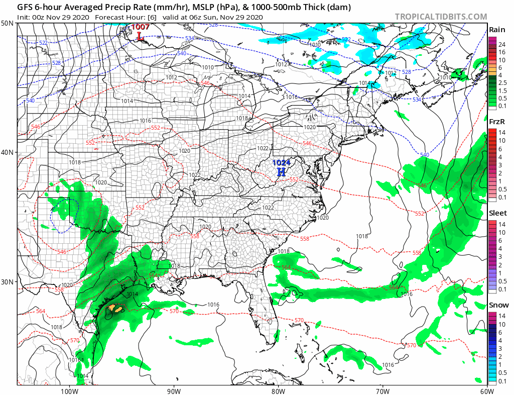
Low pressure developed along a frontal system in southern Texas on Saturday, and it will slowly strengthen as it moves northeastward tonight and Sunday. As it strengthens, it will draw moisture northward from the Gulf of Mexico, while colder air continues to move southward behind the storm system. This will set the stage for a couple of rather active days across the Eastern third of the nation, with several different types of weather likely.
The GFS model shows the progression of the storm over the next few days. Loop provided by Tropical Tidbits.
The biggest threat initially will be severe weather. As the warm, moist air flows northward from the Gulf of Mexico and clashes with the colder air moving in behind the storm, strong to severe thunderstorms are possible. A few storms are possible overnight in parts of Texas and Louisiana, but the threat will shift into the Gulf Coast on Sunday, parts of the Southeast and the Carolinas Sunday night, and parts of the East Coast from Florida to the Mid-Atlantic states on Monday. Some of the stronger storms may produce heavy downpours, damaging winds, and possibly some tornadoes.
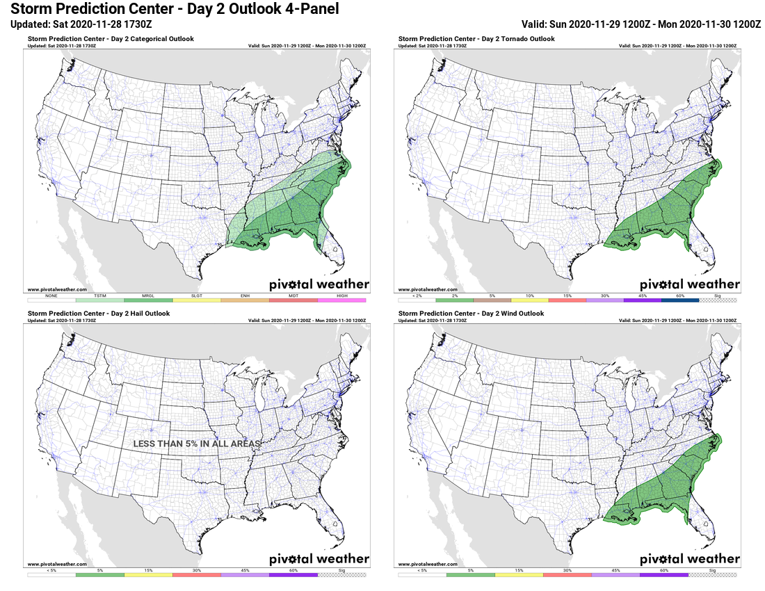
Strong to severe storms are possible from the Gulf Coast into the Carolinas on Sunday. Image provided by Pivotal Weather.
While severe weather is not common at this time of year, it is certainly not unheard of. In fact, Saturday marked the 32nd anniversary of one of the strongest tornadoes on record to hit North Carolina. On November 28, 1988, an F4 tornado tore an 84-mile path of damage across parts of North Carolina, including the city of Raleigh.
#OTD the 1988 Raleigh EF4 tornado tore an 84 mile path of destruction through central NC. While it’s getting colder, severe weather is still possible and worth keeping in mind with a storm system moving in Sun night into Mon. Have memories of this event? Share them below! #NCwxpic.twitter.com/uoapXwtaTp
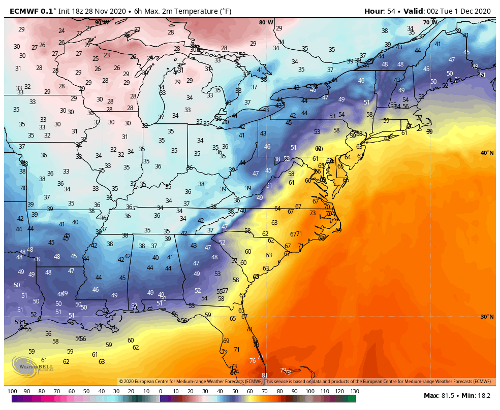
As the storm moves up the Appalachians it will bring unseasonably mild air to the East Coast, but also some heavy rainfall. Temperatures will be in the 60s and 70s across the Gulf Coast and Southeast on Sunday. By Monday, 60-degree readings will be possible as far north as southern New England, with some 70s into the Carolinas and parts of southern Virginia. The mild air may linger into Tuesday across parts of New England as well. While these temperatures are 10-20 degrees above normal, they will likely fall short of the record highs in most locations.
Monday will be a warm day by November standards up and down the East Coast. Image provided by WeatherBell.
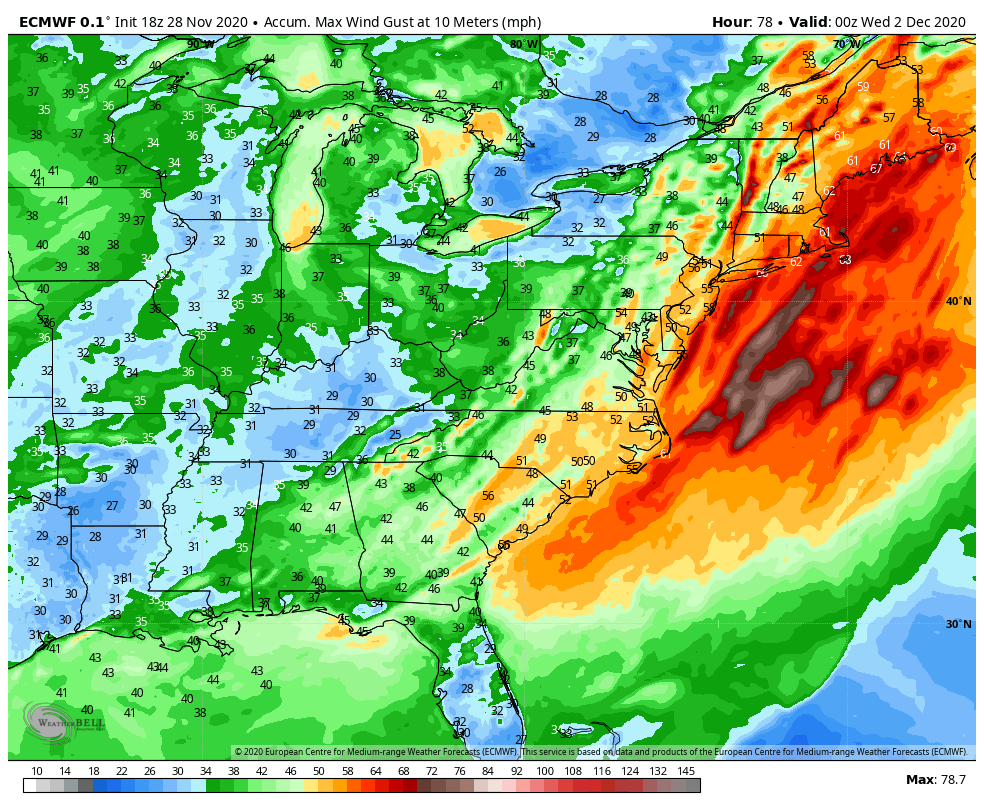
The warm weather will be transported in by strong southerly winds ahead of the system. Sustained winds of 25-35 mph will be common up and down the East Coast. Many places could see wind gusts of 50-60 mph or stronger, which could lead to power outages as trees and wires come down.
Wind gusts in excess of 50 mph are possible across the East Coast ahead of the storm. Image provided by WeatherBell.
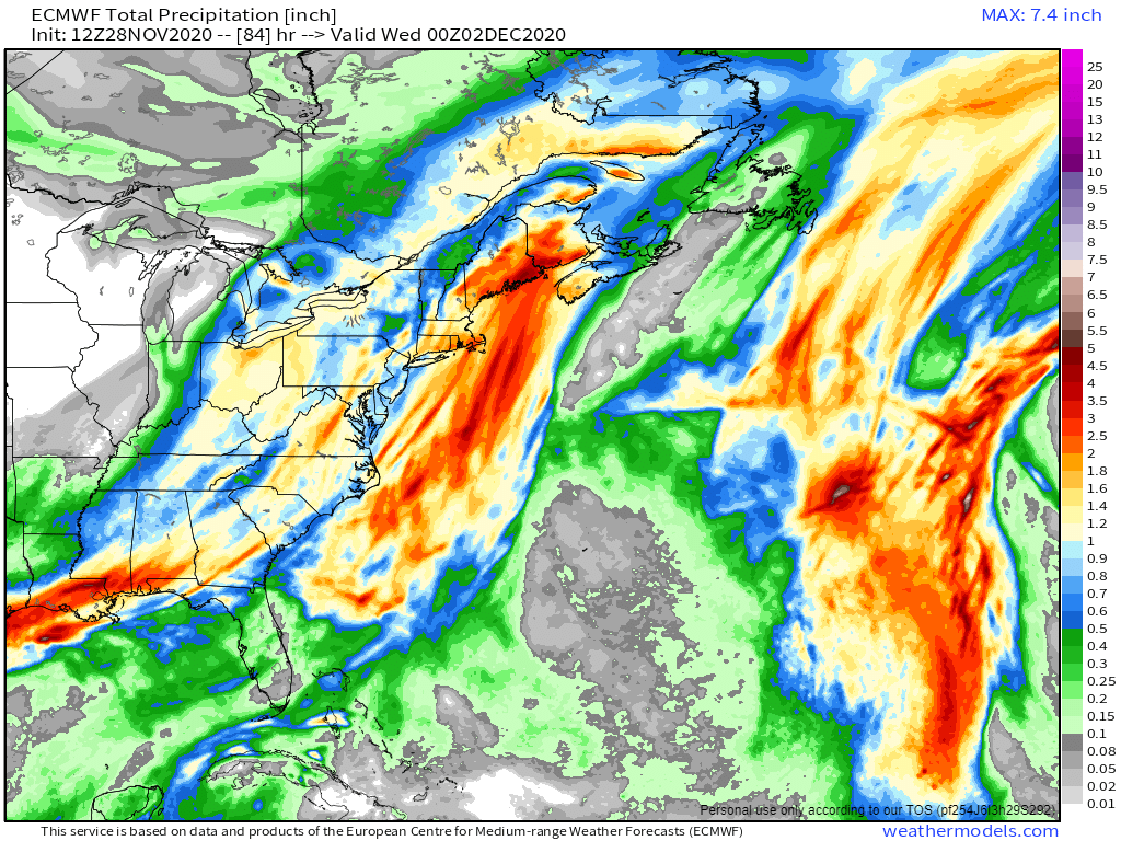
In addition to the warm weather, heavy rain is likely for much of the East. The warm, moist air being drawn northward from the Gulf of Mexico will be deposited up and down the East Coast later Sunday into Monday, and early Tuesday for parts of New England. Rainfall totals of 1-2 inches will be common, with some places possibly picking up 3 inches or more, especially in parts of eastern New England. While this will help put another significant dent in the long term drought that the region is experiencing, too much rain at once will likely lead to flooding in some areas.
Heavy rain is likely across the East Coast Monday into Tuesday. Image provided by Weathermodels.com
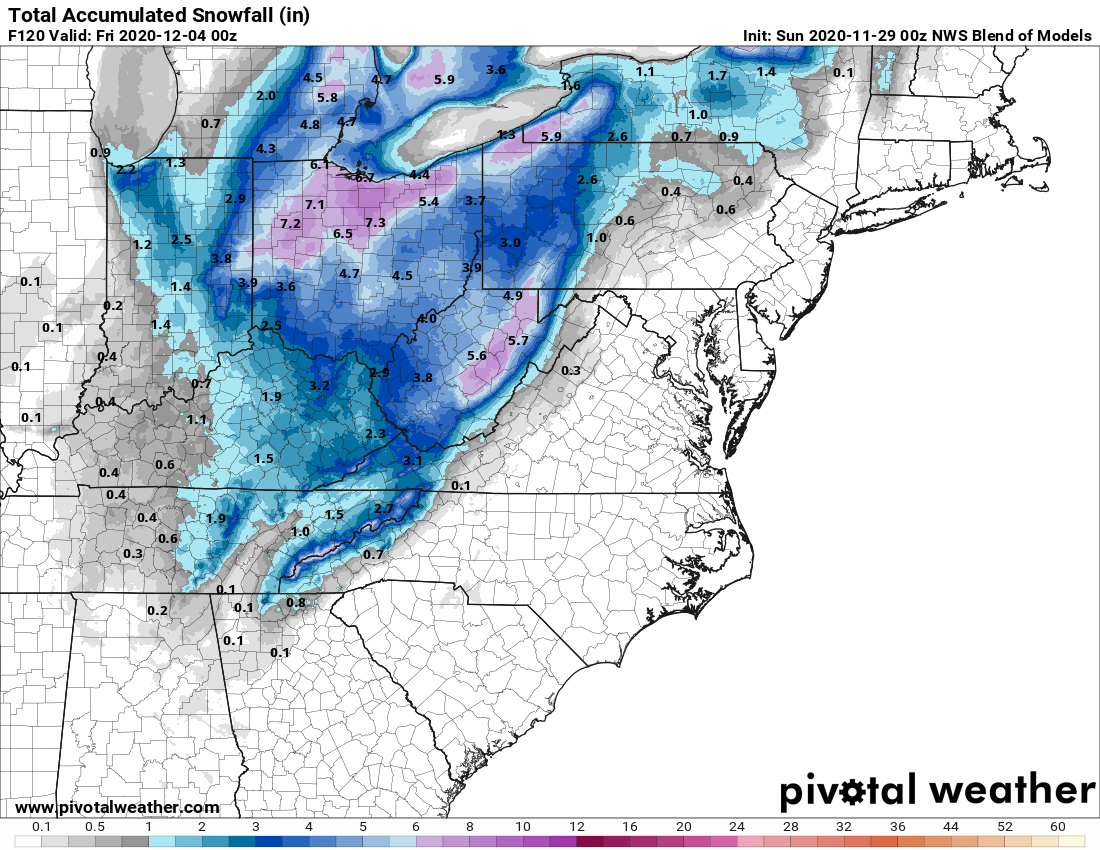
While all of this is going on ahead of the storm, a different scenario will be evolving on the storm’s back side. Colder air flowing southward from Canada will clash with the warm air, resulting in snow across parts of the Great Lakes and the Appalachians. The snow will be accompanied by gusty winds, lowering visibility in many locations, resulting in very hazardous driving conditions. While the snow won’t be exceptionally heavy, many places could receive upwards of 4-8 inches by the time everything winds down. Across the higher elevations of the Appalachians, even into the southern Appalachians, some heavier amounts are possible as well. As the systems gets caught under an upper-level low pressure system in southeastern Canada, it may produce some lake-effect snow into mid-week downwind of Lakes Erie and Ontario.
Accumulating snow is expected behind the storm system. Image provided by Pivotal Weather.
Once this system pulls away, things will quiet down across the East for a few days, but there are signs that another system could impact parts of the East next weekend.
A rather strong storm system will wreak all sorts of havoc on a large swath of the nation through the weekend and into Monday.
Low pressure is moving into the Plains states today, producing some strong to severe thunderstorms from Texas into the Southern Plains. That’s just the start of what will be a busy few days. As the storm moves into the southern Plains tonight, showers and thunderstorms, some strong to severe, will spread from Texas into the Mississippi Valley. To the north, snow is expected across the Central Plains. Some locations could pick up 6-12 inches this weekend in a swath from Nebraska and South Dakota into parts of Iowa, southern Minnesota, and Wisconsin.
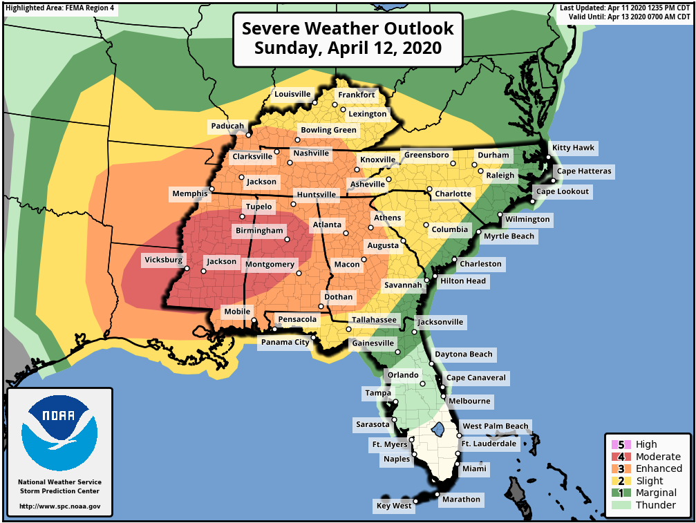
Easter Sunday is the day that will likely grab most of the headlines away from the pandemic for a day. As the system moves into the Ohio Valley, warm, moist air will be drawn northward from the Gulf of Mexico, and as this clashes with the cold air advancing southward behind the storm, the ingredients will be in place for a severe weather outbreak. Severe weather may be ongoing as Easter Sunday dawns across the Lower Mississippi Valley, but activity will spread eastward during the day across the Deep South and the Tennessee Valley. Some of the stronger storms may produce damaging winds, large hail, torrential downpours, and likely numerous tornadoes. The risk will continue well into the overnight hours, especially in Georgia, eastern Tennessee and western portions of the Carolinas.
A severe weather outbreak is possible across a large portion of the South on Easter Sunday. Image provided by the Storm Prediction Center.
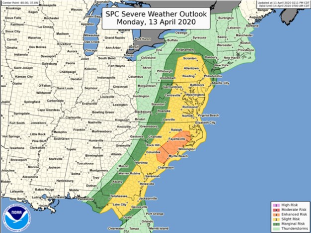
By Monday, the system will move into Ontario, dragging a strong cold front across the Eastern United States. Warm, humid air will continue to flow northward ahead of this front, triggering more showers and thunderstorms during the morning and early afternoon from northern Florida into the Mid-Atlantic states. Some of these storms could produce hail, strong winds, heavy downpours, and some tornadoes, especially from the Carolinas to the Delmarva Peninsula.
The severe weather threat shifts to the East Coast on Monday. Image provided by the Storm Prediction Center.
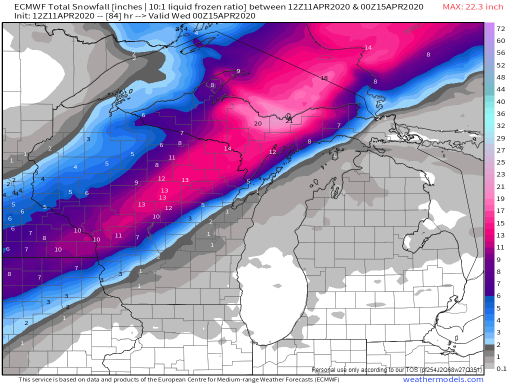
To the north, heavy snow will continue behind the storm from northern Wisconsin into the Upper Peninsula of Michigan and Ontario. Snowfall totals of 10-20 inches or more are likely. Winds gusting to 40-50 mph will create significant blowing and drifting of the snow, with blizzard conditions at times.
Heavy snow is likely from Wisconsin in the Upper Peninsula of Michigan Sunday into early Tuesday. Image provided by Weathermodels.com
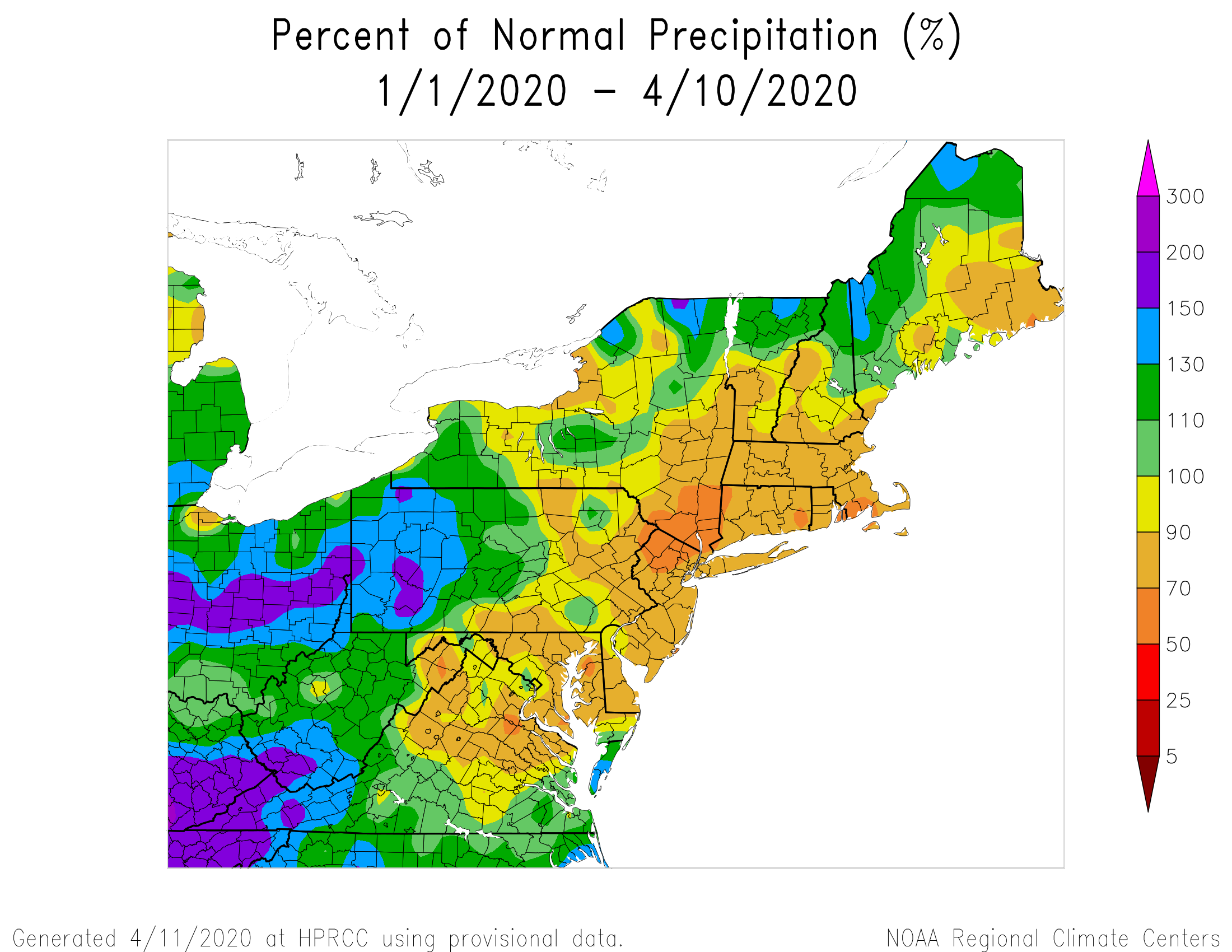
In the Northeast, the big story will be the wind. Rain will be a secondary concern, with rainfall totals of 1-2 inches or more possible across much of the region. Some embedded thunderstorms may produce heavier downpours, especially in western New England and eastern New York, but flooding isn’t much of a concern. Precipitation has been below normal across much of the area through a good chunk of the winter and early Spring, so the region needs all the rain it can get, though maybe not quite this much at once. There will be some ponding on the roadways, and some of the smaller streams may overflow, but widespread flooding shouldn’t be a problem. The wind, on the other hand, will be a major problem.
Precipitation has been below normal across much of the Northeast during the first 100 days of 2020. Image provided by the Northeast Regional Climate Center.
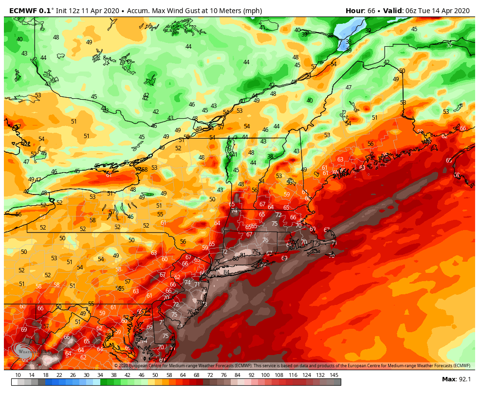
As the system gets cranked up in Ontario, strong southerly winds will develop across the region. These will bring milder air into the region. We won’t quite reach the 90s that will set records across Florida on Monday, but 50s and 60s are still a bit above normal for mid-April around here. Southerly winds will increase Monday morning, with sustained winds of 25-35 mph expected during the afternoon. Wind gusts of 60-70 mph or higher are expected as well. This will likely result in power outages as they take down trees that are starting to show their leaves, along with power lines. Winds should start to diminish during the evening as a cold front moves through, bringing an end to the rain and shifting the winds into the west.
Wind gusts of 60-70 mph or higher could be widespread across the Northeast Monday afternoon. Image provided by WeatherBell.
Conditions should improve on Tuesday across the Northeast as high pressure builds in with some sunshine developing, but it will still be breezy as the now-powerful storm moves into northern Quebec, where heavy snow will likely continue.