The weather pattern flips this week, bringing widespread rain and a high likelihood of flooding and flash flooding to the Northeast and Mid Atlantic.
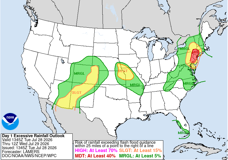
Excessive Rainfall outlook for June 28th, with a noteable Moderate risk around New York City and New Jersey. Image provided by NOAA/WPC
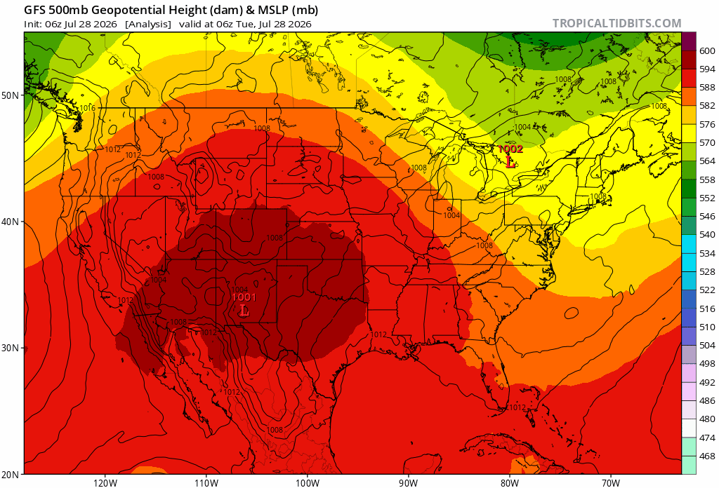
Through the 29th to the 31st of July, a strong surface low will move quickly over the northeast bringing signifigant rain across the region. On Tuesday the 28th, an upper level trough will redirect the surface low along its southern edge and off the coast as it develops into a strong cut off low – A low pressure system that is disconnected from the prevalent wind direction – that persists until Friday the 31st. While the system is moving from the west-northwest initially, the cut off low will redirect moisture from the great lakes to the southeast, before moving northward along the Atlantic coastline.
Northeast weather patterns setup for a widespread flooding event. The surface low stalls off of new england Loop provided by Tropical Tidbits.
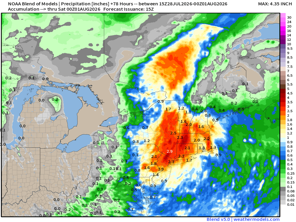
Once in place, this cut off low will remain through Friday the 31st, bringing rainfall totals between 2 and 5 inches in New York and western New England, and 1 to 3 inches further east. The movement of the surface low could see this heavy rain extend as far south as North Carolina, though the most certain area is focused around NYC and the surrounding states. Localized totals could potentially exceed 6 to 7 inches. The 29th will see most of the rainfall from this system as it sets up over the region, with follow up showers moving through eastern New England on Thursday and Friday.
Rainfall through the night of the 31st. Widespread 2-4 inches is likely, with potentially higher localized totals. Image provided by Weathermodels.com
As heavy rainfall progresses, storm drains could get overwhelmed as their capacity is exceeded. Underpasses and other low lying areas will be most suceptible to flooding as drains back up, and water levels could rise quickly. While most of this water will be standing water, it only takes a few inches for a car to become stranded. The water also wont necessarily be clean water, as ground debris is picked up by rainwater flowing into the now flooded area.
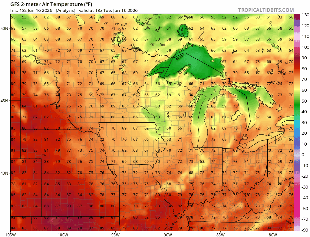
After a calm weekend following the severe weather the week of June 7th, Severe weather returns to the Midwest this week.
Rainfall totals in the Midwest on June 17th, with most of the region getting between 1 and 2 inches of rain. Image provided by Pivotal Weather
A low pressure system is sweeping through the Midwest along the jet stream, meeting warm Atlantic moisture as it does, bringing severe thunderstorms, wind, hail, and tornadoes as they collide. Fortunately temperatures are expected to remain cool in the Midwest, with highs in the 60s and 70s, and lows in the 50s between the the 17th and the 20th.
Temperatures in the Midwest to remain in the 60s and 70s from the 17th to the 20th. Loop provided by Tropical Tidbits
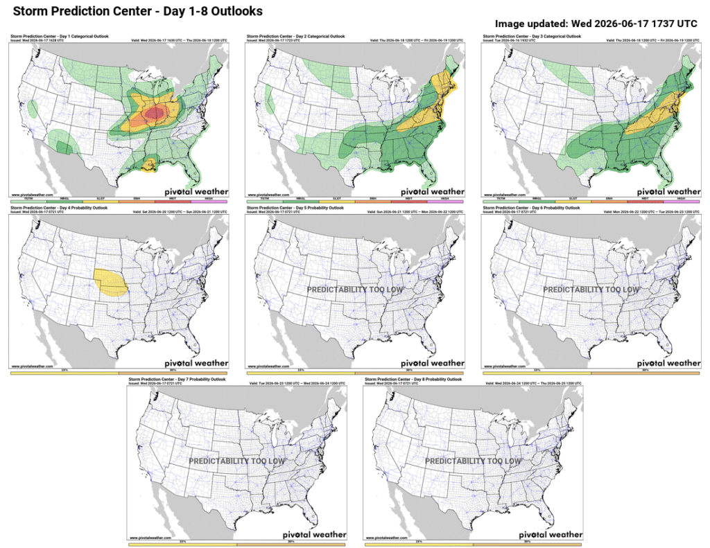
Severe weather, including tornadoes, hail, wind, and thunderstorms, are expected to remain in the region today, moving into the Northeast on Thursday.
Severe weather remains in the Midwest on the 17th before moving east. Image provided by Pivotal Weather
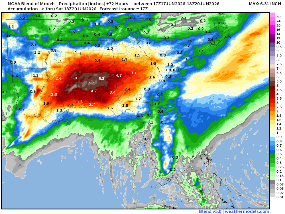
In the South, a large region of moisture is expected to bring excessive rainfall to to the area as it moves inland before combining with the system in the north. Southeast Mississippi and Southern Alabama are expected to get up to 5 or 6 inches of rain from the night of the 17th to the 20th with strong winds and flash flooding as the main risk, and a slight chance for tornadoes.
Tropical Storm Arthur to bring up to 6 inches of rain in southern Mississippi and Alabama from the 17th to the 20th. causing wind damage and widespread flash flooding. Image provided by Weathermodels.com
There’s an old saying in meteorology that goes “Droughts end in Floods”. That is likely to be the case over the next few days, as an extensive, and in some cases significant drought currently grips a large portion of the nation, but relief is on the way for some areas.
Drought conditions continue across a large portion of the nation. Image provided by the National Drought Mitigation Center.
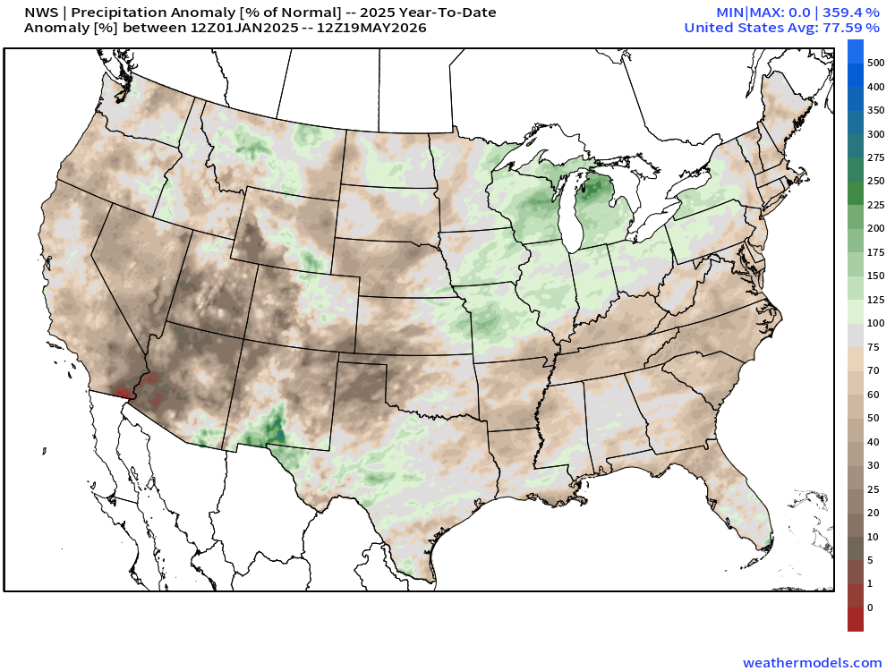
As is typical with a La Nina pattern that had been in place since last summer, dry weather was common for much of the southern tier of states over the past several months. Many locations from eastern Texas to the Southeast and up the East Coast are running precipitation deficits on the order of 6 to 12 inches or more over the past 6 months. This has worsened drought conditions in many areas, and created them in spots that weren’t that dry to begin with. That dry pattern is about to change.
Rainfall totals are well below normal across much of the South and the East this year. Image provided by weathermodels.com
A strong cold front extends from the Great Lakes to Texas this evening, and while the northern portion of the front will head eastward tonight and Wednesday, southern portions of the front will become stationary from Texas to the Carolinas over the next few days. With a southerly flow south and east of the front, moisture from the Gulf of Mexico will continue to flow northward, resulting in numerous episodes of showers and thunderstorms over the next several days from Texas to the Southeast.
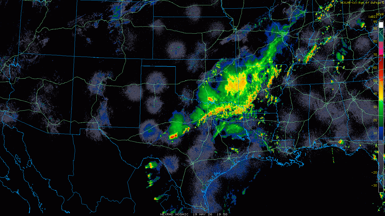
Strong to severe thunderstorms are ongoing late this afternoon from Texas to the Ohio Valley. Loop provided by the College of DuPage. (Click for loop)
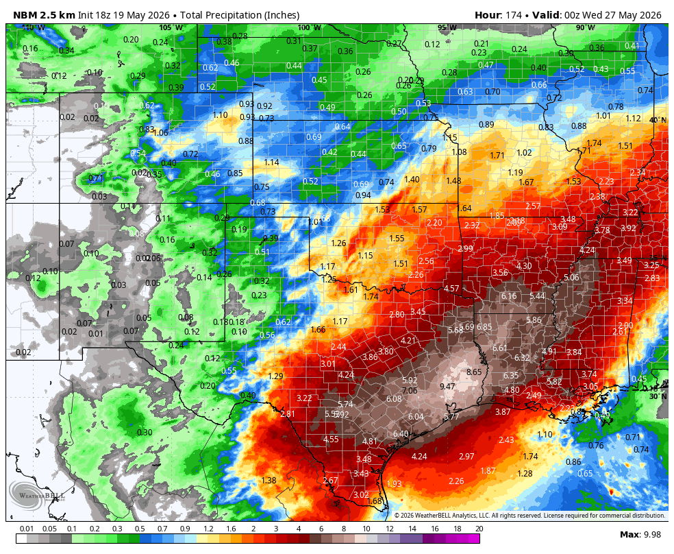
Strong to severe thunderstorms are already occurring across parts of Texas, and they will spread across much of the remainder of the Lone Star State this evening. With that front stalled out across central portions of the state for the next few days, waves of low pressure will ride along it, resulting in numerous episodes of heavy rain and thunderstorms. While severe weather is still possible along the tail end of the front in west Texas on Wednesday, heavy rain will be the main threat for the next several days. Between now and next Tuesday, much of southern and eastern Texas as well as nearby portions of Louisiana, Arkansas, and Mississippi could see as much as 4 to 8 inches of rain, with isolated totals to 10 inches or more possible. While this will wipe out the precipitation deficits, it will also result in flooding in many areas, especially urban areas like Houston where flash flooding is common during heavy rainfall.
Very heavy rain is likely across portions of Texas and the Lower Mississippi Valley over the next week. Image provided by WeatherBell.
Farther east, drought conditions remain very problematic across parts of the Southeast, where wildfires have been a problem this Spring. While some rainfall will move in over the next few days, the bulk of the heavy rain will stay north of this area, with the front remaining stationary across the Tennessee Valley and the Carolinas. In these spots, rainfall will still be significant, on the order of 1-3 inches and locally heavier, over the next several days, but nowhere near what will fall across Texas and the Lower Mississippi Valley. Drought conditions persist in this region as well, so the rainfall will be welcome.
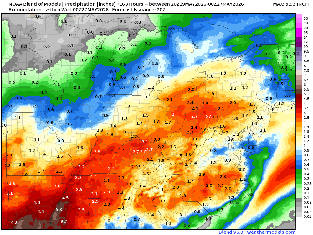
Several rounds of thunderstorms and heavy rain are likely from the Tennessee and Ohio Valleys to the Carolinas and parts of the East Coast this week. Image provided by weathermodels.com
Heavy rainfall is also likely across parts of the Ohio Valley, likely resulting in flooding in some spots. This are has received persistent rainfall through the Spring, so drought it not an issue, and the heavy rain falling on ground that is already saturated, or near saturation will end up in flooding. Many rivers in the region are already near flood stage, especially across southern Indiana and southern Illinois, so the addition rain will send these rivers over their banks.
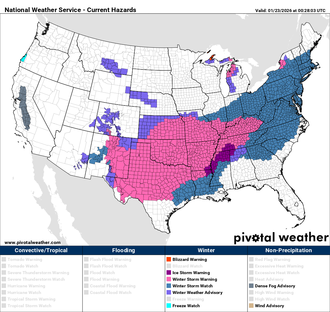
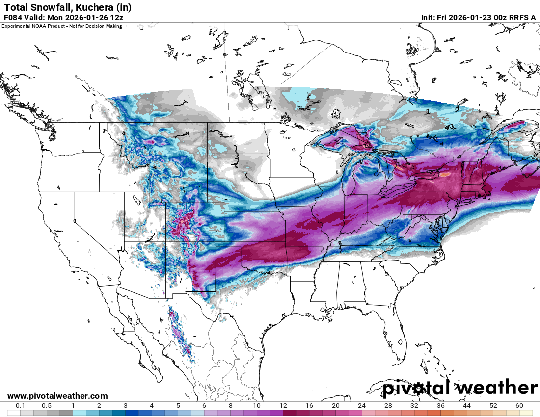
As an arctic airmass pours into the eastern two thirds of the nation, a developing low pressure system will bring wintry weather to many areas that are unaccustomed to it.
A variety of winter storm watches, warnings and advisories are in effect from the Rockies to the East Coast. Image provided by Pivotal Weather.
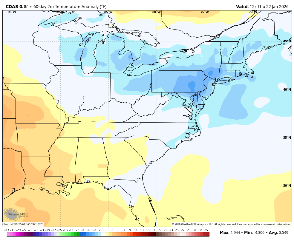
The overall weather pattern so far this winter has been dominated by a trough of low pressure centered over the Great Lakes with ridging taking place across either the Southeastern U.S. or the Rockies. The eastern troughs have expanded and contracted as the polar vortex has expanded and contracted this winter season. This has led to colder than normal temperatures from the Great Lakes to the Northeast since the middle of November, although there was a brief thaw back in early January. In addition, this pattern has resulted in weather systems generally moving into the region from the west or northwest. This is has led to some fairly frequent snow events through the winter but none of them have had much moisture to work with, so snowfall has generally been on the light side, except for lake-effect events. This has been due to the storms originating in areas with not a lot of moisture limiting the potential snowfall from them.
Temperatures have been below normal across the Great Lakes and Northeast since mid-November. Image provided by WeatherBell.
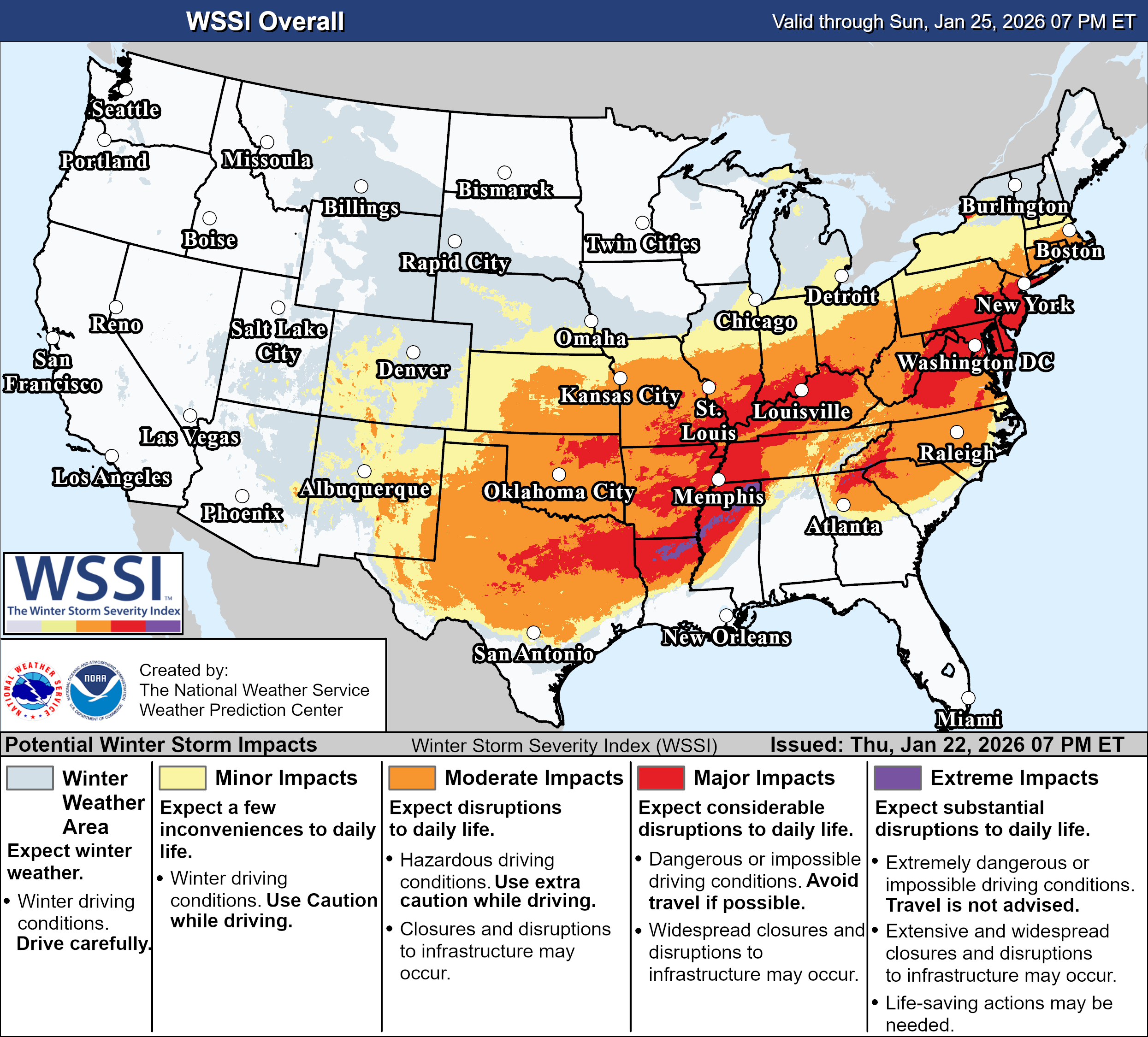
The pattern is in the midst of a change as there’s been a major expansion of the polar vortex over the last week. This is going to result in a deep trough developing over the eastern half of the country over the next few weeks. The pattern is shifting to one where colder airmasses will be moving into the region on a regular basis through early February. These airmasses will also be settling further south on a more regular basis over the next couple of weeks. In addition, storm systems will start to develop along the arctic boundary further south in the country which will allow these potential storms to tap into moisture from the Gulf of Mexico. In laymen’s terms, the pattern is becoming much more dynamic and our exposure to heavier snowfalls is increasing quite a bit over the next 2-3 weeks, especially in comparison to what we’ve seen so far this winter.
A storm system will result in significant impacts from Texas and the Southern Plains to the East Coat. Image provided by the Weather Prediction Center.
That starts over the next few days as arctic air pours into the nation while a low pressure system moving out of the Southwest encounters that colder air. It will draw moisture northward from the Gulf, and as it encounters that colder air at the surface, it will fall as freezing rain in a large swath from parts of Texas and the Southern Plains across the Tennessee Valley and into parts of the Southeast and Mid-Atlantic states. Some significant ice accretions are possible from parts of northeastern Texas and southern Oklahoma across Arkansas, northern Mississippi, Tennessee, and Kentucky, into the Carolinas and Virginia, beginning later Friday in western parts of this region, late Saturday as you head toward the Carolinas. Just to the north of these areas, where the cold air is a little deeper, some significant sleet is possible, especially in parts of Oklahoma and Arkansas. This will be a long duration storm, with precipitation likely not ending until Sunday for much of this region. This will likely cause widespread travel disruptions and power outages, with extended recovery times expected.
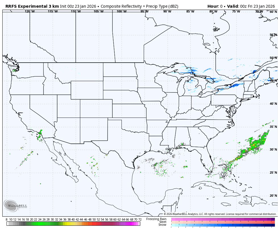
The system will produce a variety of weather as it makes its way across the nation. Loop provided by WeatherBell.
Farther north, heavy snow will be widespread north of the track of the low pressure system from the Southern Plains to the Ohio Valley. Many locations could pick up a foot or more of snow. Across the eastern Great Lakes, the snow will be enhanced by lake-effect snow as the arctic air moves in. Areas downwind of Lake Ontario could see totals upwards of 2-3 feet.
Heavy snow is likely from the Southern Plains to the Midwest and parts of the Northeast. Image provided by Pivotal Weather.
As the system moves to the East Coast, things become a little more complicated. The storm will strengthen, but the exact track it takes has a big impact on what type of precipitation falls, and how much accumulates. Right now, it looks like snow will change to sleet and freezing rain Saturday night and early Sunday across much of Virginia and the Delmarva Peninsula, including the Washington and Baltimore areas, with plain rain right along the coast. This will keep snow accumulations significantly lower. The changeover should get into the Philadelphia area and parts of New Jersey as well Sunday evening, which would result in lower accumulations. To the north, moderate to heavy snow is expected in parts of New York and central and southern New England, but again, a track farther north could bring sleet and/or rain into parts of Long Island and southern New England, possibly into New York City as well. Up here, snow won’t even begin in New York until daybreak Sunday, and in parts of southern New England until later Sunday afternoon or evening. Precipitation won’t end in these areas until sometime on Monday, possibly Monday night or early Tuesday in eastern New England. Once again, in places where precipitation falls as all snow, many areas will pick up a foot or more.
Well below normal temperatures will continue east of the Rockies for the next week or more. Loop provided by Weathermodels.com
Another surge of arctic air will settle in behind this storm across parts of the nation’s mid-section by the end of the weekend, and into the East early next week. As mentioned above, this pattern is likely to remain in place through the rest of January and into at least early February.
After several weeks of mainly dry weather from the Mid-Atlantic to the Northeast, many areas are experiencing abnormally dry to drought conditions, with some areas even seeing an extreme drought. A developing low-pressure system could bring some relief to areas.
Dry weather over the last several weeks has caused most of the Eastern U.S. to become dry, with some areas even experiencing extreme drought conditions. Image provided by the National Drought Mitigation Center.
A system is developing off the coast of the Southeastern United States and is beginning to move north. At the same time, another smaller system is moving out of southern Canada and through the Great Lakes. By the end of the weekend, these two systems will combine near the Mid-Atlantic and progress toward New England.
A small low-pressure system will combine with a larger system in the Atlantic, then strengthen, bringing gusty winds and heavy rain from the Delmarva Peninsula to New England. Loop provided by Pivotal Weather. (Click for loop)
As this system strengthens, it will bring the potential for strong and gusty winds from the Delmarva Peninsula to the southern coast of New England through the beginning of the week. This region still has most of its leaves on the trees, so these gusty winds could bring down the heavy trees, resulting in more widespread power outages.
A coastal storm is expected to bring strong winds to coastal areas in the Northeast and Mid-Atlantic. Loop provided by WeatherBell.
This system is also expected to bring heavy rain across the region. While much of the region is experiencing a drought and desperately needs rain, some areas, especially those closer to the coast, are at a higher risk of flooding. The greatest potential for flooding will be between Sunday afternoon and Monday night, with coastal flood watches and advisories already in effect spanning southern New England and the Mid-Atlantic. In combination with the highest rainfall totals near the coast, tides are still running higher than usual from the astronomical high tides that occurred earlier this week. Strong winds will also contribute to the formation of large waves offshore, creating a long fetch. The persistent east and northeast flow will allow these large waves in the long fetch area to move onshore, posing a greater threat to flooding in coastal areas, especially from Cape Cod to the northern Mid-Atlantic through Monday evening.
Areas closer to the coast from Massachusetts to Delaware are expected to receive the heaviest rainfall from this system, leading to the potential for flooding. Image provided by Weather Models.
Impacts will begin to diminish Monday night as the system starts to pull away from the region before high pressure builds in behind over the Northeast and Mid-Atlantic, allowing for drier weather through at least the middle of the week.
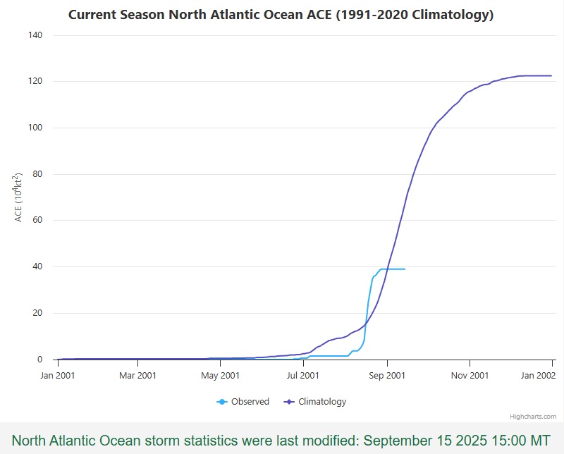
September is normally the peak of hurricane season, but that hasn’t been that case this year, things have been quiet for a while now, though that could be changing.
Tropical Cyclone Activity in the Atlantic is now below normal for the season. Image provided by Colorado State University.
The last time there was an active system in the Atlantic was on August 29, when Tropical Storm Fernand became extratropical more than 600 miles east-southeast of Newfoundland, in the open waters of the North Atlantic. Climatologically, the peak of the season is September 10 – the day you are most likely to observe a tropical cyclone somewhere in the Atlantic, Caribbean, or the Gulf. Instead, we’re at 18 days and counting without a system. How unusual is that? The last time there were no active systems in the Atlantic between August 29 and September 15 was in 1939, right at the start of World War II. However, that quiet period may be coming to an end over the next few days.
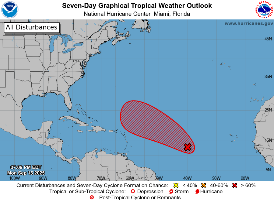
A tropical wave in the central Atlantic could become a tropical depression in the next few days. Image provided by the National Hurricane Center.
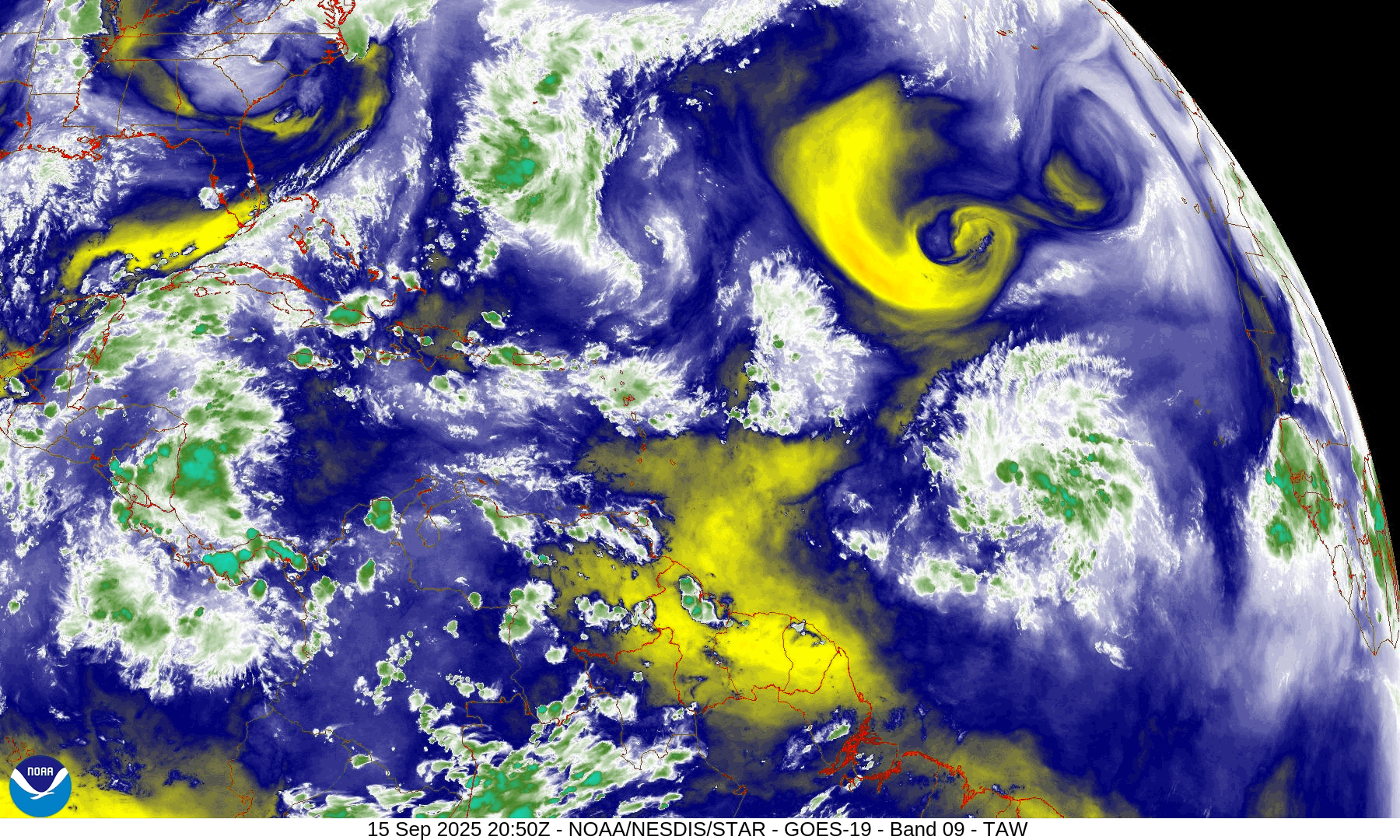
A tropical wave that is making its way across the Atlantic’s Main Development Region is slowly getting its act together. Shower and thunderstorm activity is disorganized at this time, and upper-level conditions are not that favorable right now, but as the system continues west to west-northwestward over the next few days, some additional development is likely. There is some dry air ahead of the system, but as it starts to gain latitude, it should encounter a more moist environment. Additionally, there is an upper-level low pressure area to the north of the system, but as it heads westward, it should pull away from that, encountering more favorable conditions for development. Sea Surface Temperatures are already warm enough, so that shouldn’t be an inhibiting factor.
Satellite loop shows an upper-level low will dry air north of the tropical wave. Loop provided by NOAA. (Click on map for loop)
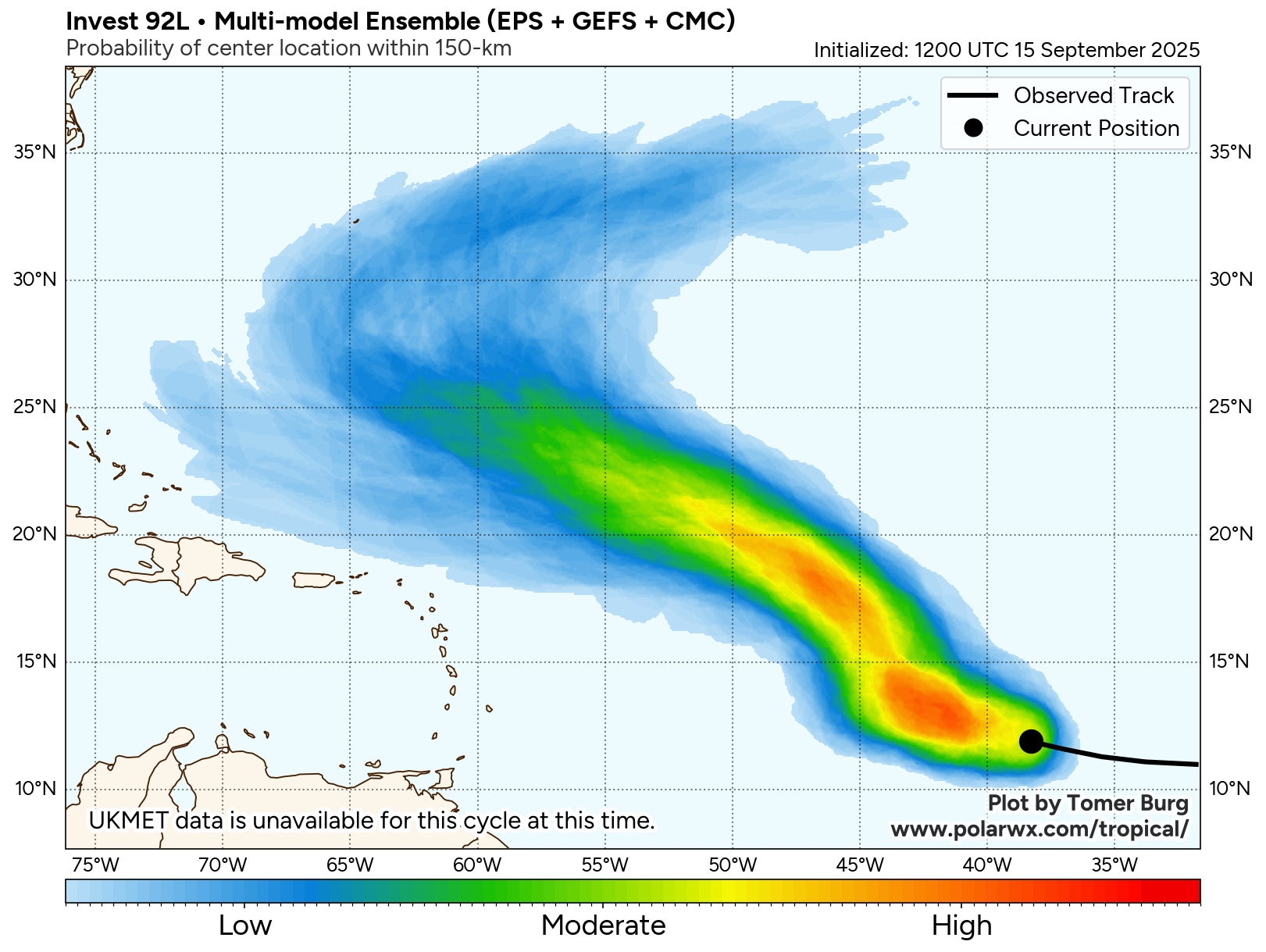
Most of the forecast models are showing the potential for the system to organize into a tropical depression during the middle to latter portion of the week as it continues to head west-northwestward. Additional strengthening is expected, and the system could become Tropical Storm Gabrielle by this coming weekend. As for where it should go, with a ridge of high pressure over the central Atlantic, it should continue west-northwestward through much of the week. By the weekend, it could reach the western edge of that ridge and turn more toward the north and the eventually northeast and out to sea. Where it makes that turn will determine whether the system will eventually be a threat to Bermuda, but otherwise, it does not look like this system will be a threat to any other land areas over the next 5-7 days.
Forecast models show the system staying north of the Caribbean over the next week. Image provided by Tomer Burg.
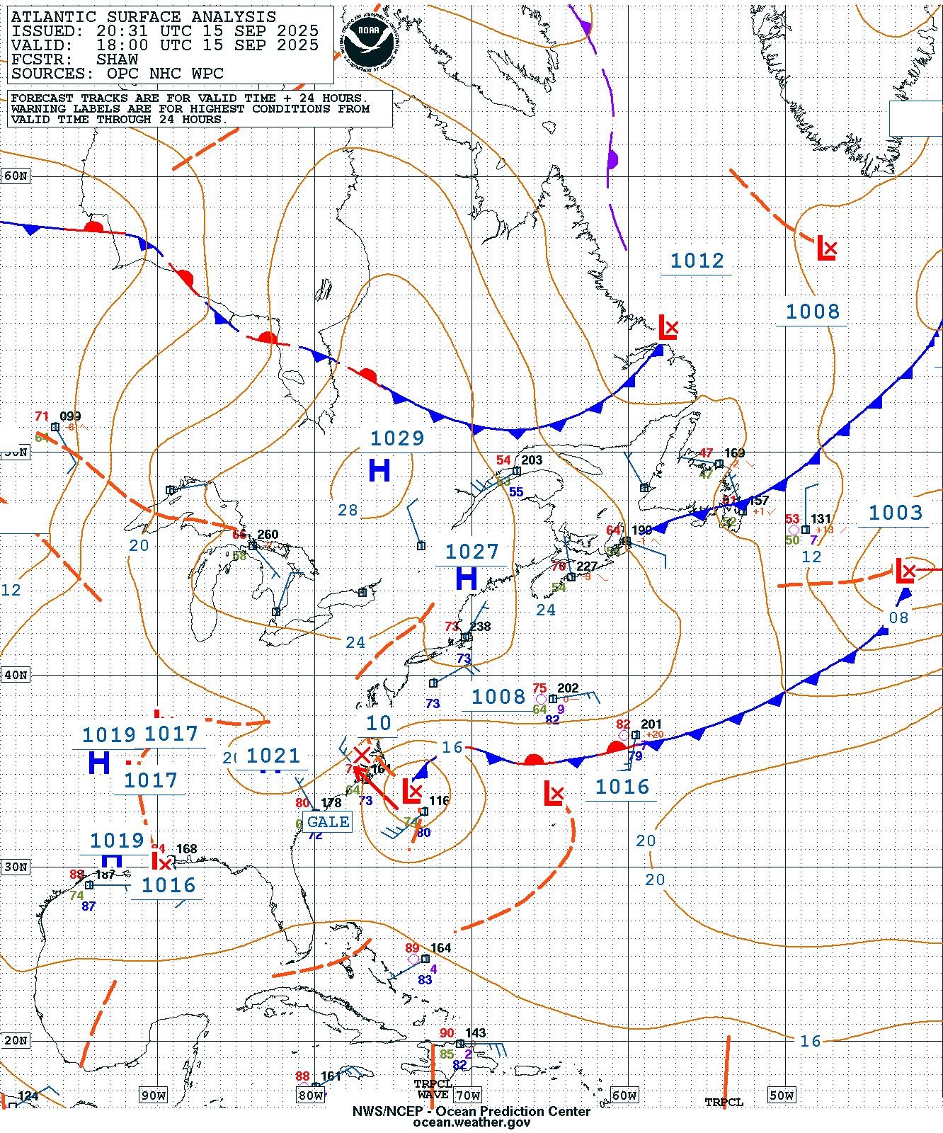
Closer to the United States, there’s another system we’re keeping an eye on, though it isn’t tropical at this time. Low pressure has developed along an old frontal boundary off the North Carolina coastline. Meanwhile, there’s an upper-level low pressure area over central North Carolina. That upper-level low will pull the surface storm towards the coast of eastern North Carolina and the Virginia Tidewater into Tuesday. This will result in some heavy rain along with embedded thunderstorms across the region over the next day or two. Locations from Richmond to Raleigh and points eastward could receive 2-4 inches of rain by Wednesday morning, with isolated totals in excess of 5 inches possible.
Surface map for the western Atlantic Ocean from Monday evening. Image provided by the Ocean Prediction Center.
With a large area of high pressure to the north, the system won’t move that much for the next 24 hours, but should start to pull away and head out to sea by Wednesday and Thursday. The gradient between the high to the north and the low pressure area will result in some rather gusty winds, especially near the coast. Wind gusts of 35-45 mph and perhaps stronger are expected for coastal areas from Southern New Jersey to the North Carolina Outer Banks through Wednesday. In addition to the hazardous marine conditions, this will create a high risk for dangerous rip currents at beaches in this stretch. That high pressure area will also block any northward progress the storm will try to make, preventing much-needed significant rainfall from reaching portions of New England and southeastern New York, where a significant drought has been worsening over the past few months.
Strong wind gusts are expected along the Mid-Atlantic coast into Wednesday. Image provided by WeatherBell.
Many families across the United States will be trying to squeeze in one last summer activity this weekend, as Labor Day marks the unofficial end of the summer season. Fortunately, many areas will experience sunshine and dry weather as high pressure dominates the majority of the pattern across the country, while others may not be so lucky.
A large stalled front will bring rain to much of the Gulf Coast and Southern Plains through the weekend, with heavy rainfall expected. Flash flooding will be a concern for eastern New Mexico, central and western Texas, and the Central Plains on Saturday, while west and central Texas, as well as southern New Mexico, remain at risk for flooding through Sunday. Showers could also spread into the Tennessee Valley on Monday as the front remains stationary.
Heavy rain in association with a stationary front could bring the potential for flash flooding to areas across the central and southern United States on Saturday, and is expected to continue on Sunday, especially in New Mexico and Texas. Images provided by the Weather Prediction Center.
The front will also extend into the Rocky Mountains, bringing showers and thunderstorms to start the weekend. A warm front will break off and progress east on Sunday with a low pressure system moving across the northern part of the country. Areas in extreme eastern Nebraska could be at risk for flash flooding as this system begins progressing east. Temperatures will average well below normal ahead of this system and return to near normal on the backside.
Temperatures will average mainly below normal across the country on Sunday, with values expected to be well below normal in the Plains ahead of a warm front moving out of the Rockies. Image provided by Weather Models.
A cold front in association with a low pressure system slowly moving into Atlantic Canada will extend into the Mid-Atlantic and Tennessee Valley on Saturday, allowing for some extra cloudiness across the region. This system will also send disturbances through the Northeast, bringing an increase in clouds during each afternoon, especially on Saturday. Areas in extreme northern New England may also see a stray shower or two, particularly in the afternoon as the disturbance moves through.
A disturbance will bring the potential for showers and thunderstorms to northern New England on Saturday afternoon, while high pressure keeps the rest of the Northeast dry. Image provided by Tropical Tidbits.
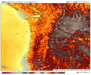
Areas along the West Coast will experience dry weather through the weekend, with temperatures averaging near normal to start the weekend, then shifting above normal toward the end of the weekend, with extreme heat possible, especially in interior areas.
Temperatures will soar into the upper 90s across western Washington, with some areas potentially reaching values close to 100. Image provided by WeatherBell.
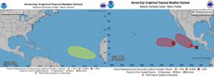
Looking at the week ahead, things are expected to remain relatively quiet. Areas across the Central U.S. will continue to see well below normal temperatures ahead of a slow moving warm front. Areas in the west, specifically in the Pacific Northwest, will continue to see above average temperatures, where hot temperatures are expected to continue through the remainder of the week. There are no active storms in either the Atlantic or the Pacific; however, some areas are being monitored for potential development as the week progresses.
Disturbances in the Atlantic and Pacific are being monitored over the next week, where environmental conditions could support the development of tropical systems. Images provided by the National Hurricane Center.
August typically brings a range of weather conditions to the United States, from excessive heat to tropical systems and everything in between. As we move into the middle of the month, we are beginning to see this play out.
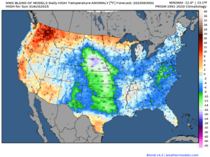
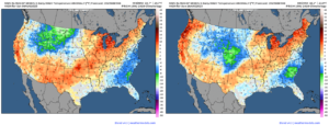
This weekend will bring dry and warm weather to much of the country. Many areas are expected to experience above-normal temperatures on Saturday. In contrast, others, including the Mid-Atlantic, Southeast, Intermountain West, and North-Central Rockies, are expected to experience below-normal temperatures. A cold front moving into the center of the country on Saturday will allow temperatures to dip below normal across the Central Plains on Sunday. Temperatures will also shift above normal on Sunday in interior areas of the Pacific Northwest as high pressure builds in across the region.
Temperatures average mainly above normal through the weekend across much of the country, with below normal temperatures in the Intermountain West, Southeast, and Mid-Atlantic. Images provided by Weathermodels.
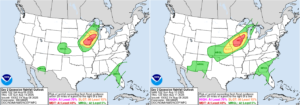
A cold front moving across the central United States will bring a marginal risk of severe weather to the Upper Great Lakes and Central Mississippi Valley, as well as the Central and Southern Plains, through the weekend. The highest risk for severe storms will be on Saturday, with a slight risk of severe weather across southwestern Wisconsin, southeastern Minnesota, northeastern Iowa, and eastern Colorado.
There is a slight risk of severe weather on Saturday for the Upper Midwest and eastern Colorado, with a marginal risk through the weekend from the Upper Midwest to the Southern Plains. Images provided by the Storm Prediction Center.
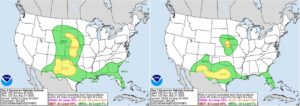
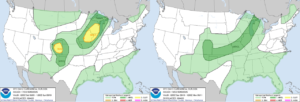
The cold front will also bring heavy rainfall to the Upper Midwest. There is a moderate risk of excessive rainfall across southwest Wisconsin, eastern Iowa, northwestern Illinois, and northeast Missouri on both Saturday and Sunday, with a slight risk extending from southern Wisconsin to eastern Kansas. A stationary front will continue to produce rain and thunderstorms across much of the Southeastern United States, with a marginal risk of excessive rainfall on both days. Meanwhile, in the Southwest, monsoonal moisture will bring showers and thunderstorms to the region with a marginal risk of excessive rainfall for both Saturday and Sunday.
The Upper Midwest will face the highest risk of excessive rainfall through the weekend, with areas such as the Southeast and Southwest also facing a marginal risk. Images provided by the Weather Prediction Center.
As we move into the beginning of next week, temperatures are expected to rise across the Northeast, with above-normal values anticipated for much of the week. The slow-moving front will bring showers and thunderstorms to the Midwest through the middle of the week before moving into the Northeast toward the second half of the week. The Northeast will see its next potential for rain as this front moves through, ending its dry stretch, which has caused some areas to become abnormally dry across the region.
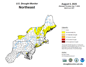
Areas of the Northeast are becoming abnormally dry as the region continues to see dry conditions. Image provided by the National Drought Mitigation Center.
The stationary front across the south will continue to bring the potential for rain and thunderstorms to much of the region through the end of the week. Areas in the Southwest will also see the possibility of showers and thunderstorms each afternoon as monsoonal moisture remains over the region. Otherwise, high pressure will continue to bring dry weather to the majority of the country.
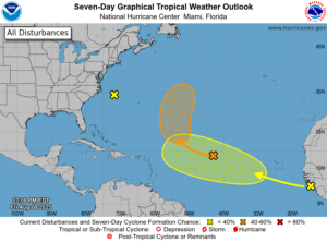
We will also be monitoring tropical development as the week progresses, since the National Hurricane Center continues to monitor areas in the Atlantic Ocean for possible development over the next seven days. Some models have been in favor of tropical development by the end of the week, but also show vastly different solutions for these systems. At this time, it is still too early to determine whether these storms will develop, never mind their storm tracks.
The National Hurricane Center is monitoring three areas for tropical development in the Atlantic over the next 7 days. Image provided by the National Hurricane Center.
Over the past few months, there has been consistent troughing over the United States, particularly in the Great Lakes region, which has led to a stormier pattern across the eastern half of the country. One factor that can influence these changes in storm patterns and consistency is teleconnections.
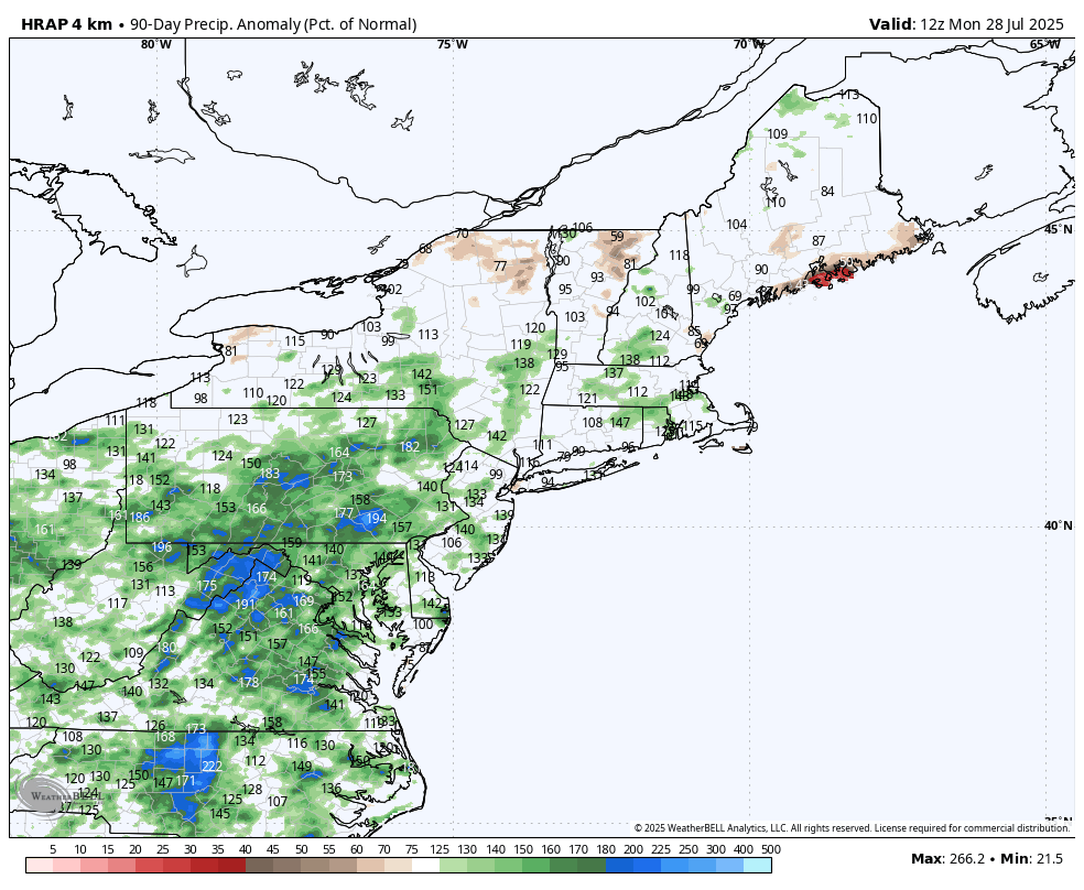
Above to well above normal rainfall has been common across the Northeast over the past 90 days. Image provided by WeatherBell.
Teleconnections are relationships between specific weather phenomena at locations often separated by considerable distances. These phenomena are correlated with particular climate patterns spanning thousands of miles and exhibit variabilities ranging from days to years. Some of these patterns can also have more significant impacts during specific seasons, while others affect the climate pattern throughout the year.
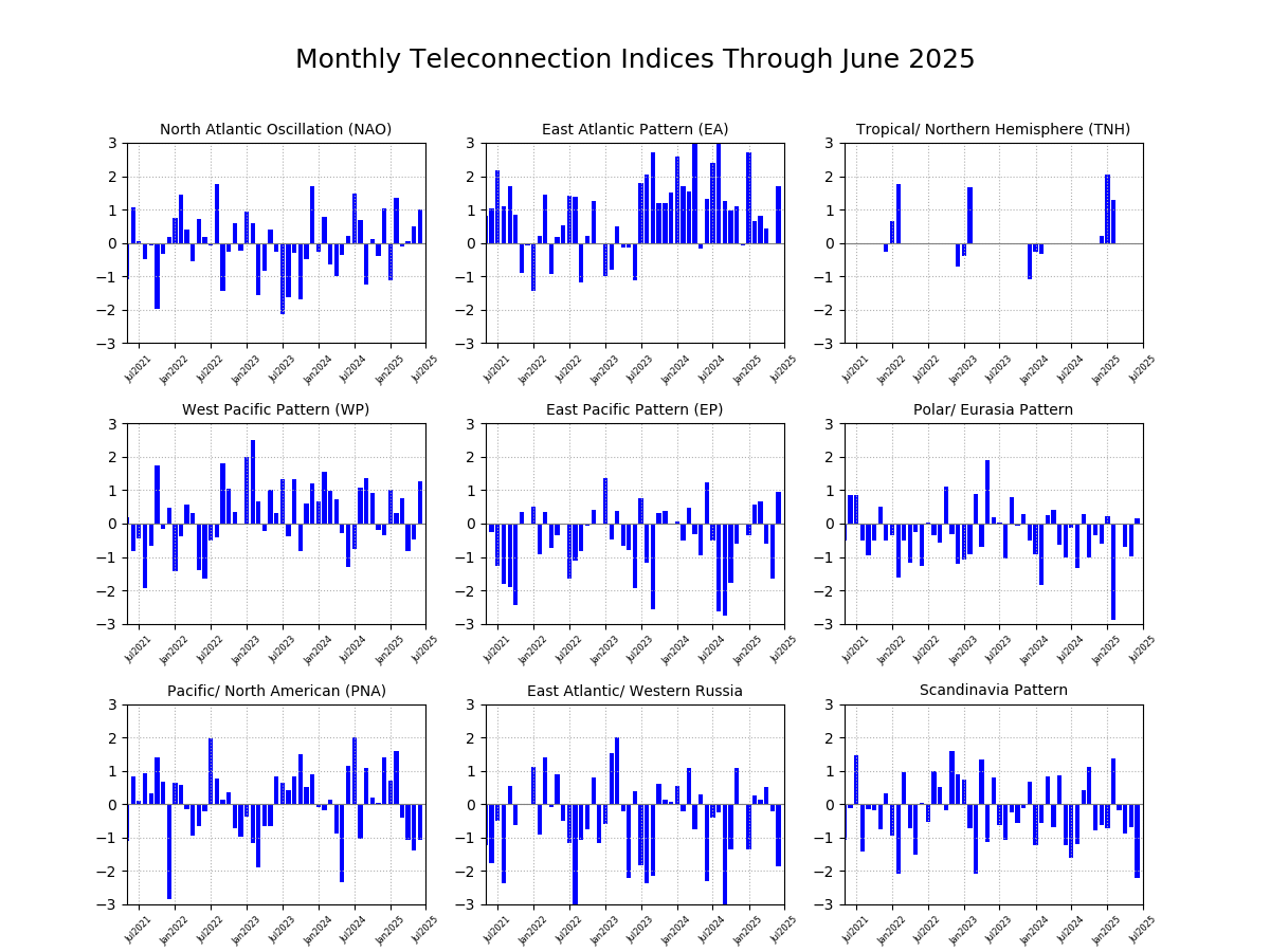
Many of the teleconnection patterns that affect the United Stated have been mostly positive since the start of the year. Image provided by the Climate Prediction Center.
Some of the major teleconnections and patterns that affect North America include the Arctic Oscillation (AO), El Niño/Southern Oscillation (ENSO), East Pacific Pattern (EP), North Atlantic Oscillation (NAO) , Pacific/North American Pattern (PNA), and Madden-Julian Oscillation (MJO). Patterns like ENSO will have a lesser impact on intraseasonal climate variability, as it can take several months to transition between phases. In contrast, the NAO will have a greater impact, as it can change between phases on a more regular basis.
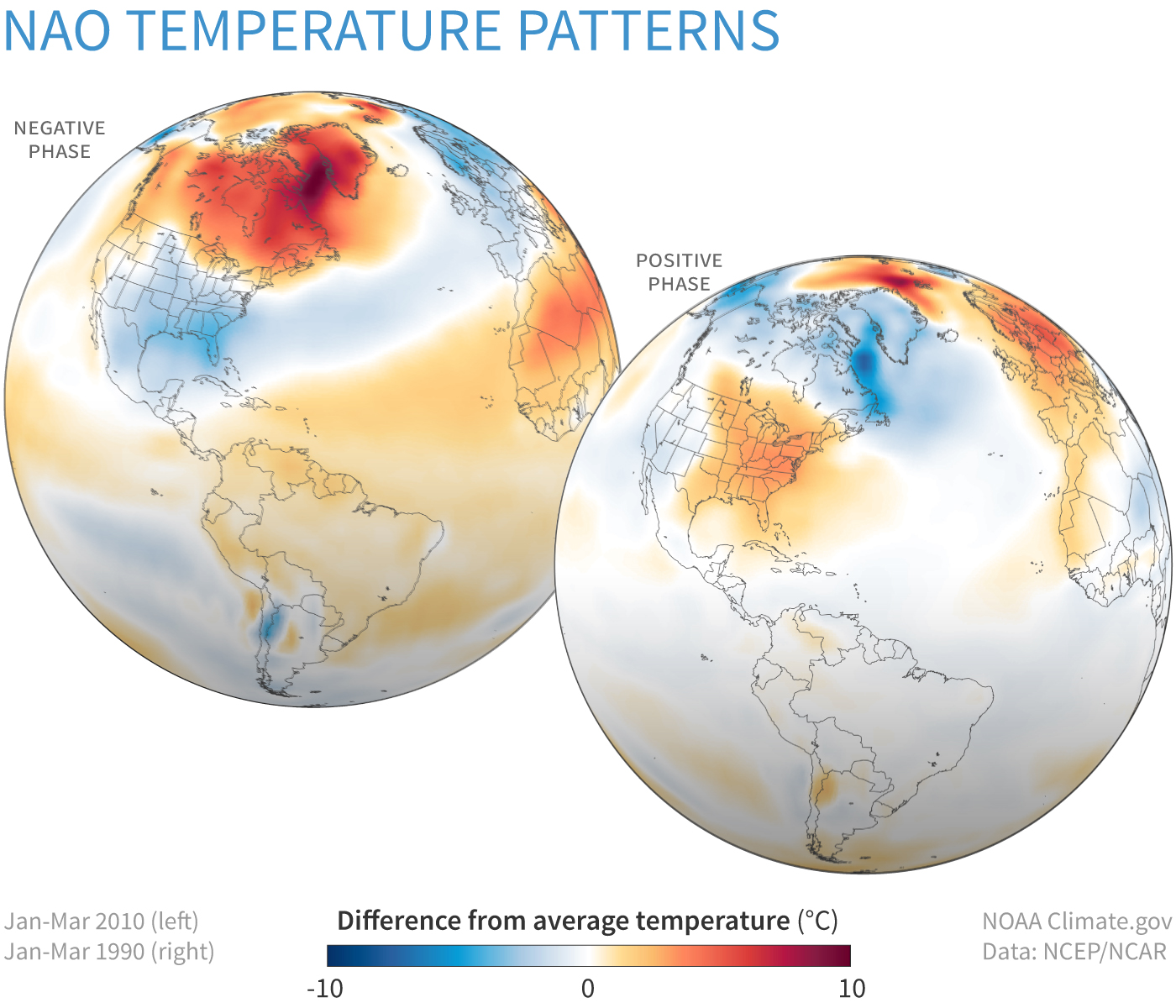
Temperature patterns for North America associated with the different phases of the North Atlantic Oscillation. Image provided by the Climate Prediction Center.
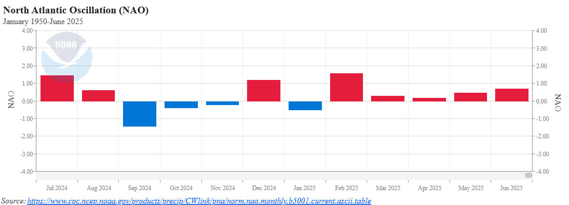
The NAO is an oscillation that impacts the climate pattern throughout the year. The positive phase will generally bring above-normal temperatures with a drier pattern to the Eastern United States, while the negative phase will produce the opposite. In the winter, a negative NAO usually leads to blocking over Greenland, and an increasing chance for more potent storms off the East Coast. The NAO has been mainly in the positive phase since early 2025. Although this may mean dry and warm conditions, the spring of 2025 averaged above normal for both temperature and precipitation across the eastern United States.
The monthly average of the NAO has been leaning positive since the beginning of 2025. Image provided by the National Center for Environmental Information
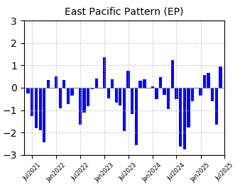
When examining other teleconnection patterns to identify the potential origins of the persistent unsettled pattern, it can be noted that the East Pacific Pattern transitioned into its positive phase in June, following a predominantly negative phase, especially over the past year. When the East Pacific Pattern is in its positive phase, the Eastern United States will experience more cyclonic activity, i.e., the persistent troughing we’ve been seeing across the Great Lakes and into the Eastern United States over the last several weeks.
The monthly average of the East Pacific Pattern shifted positive in June after leaning negative for the last year. Image provided by the Climate Prediction Center.
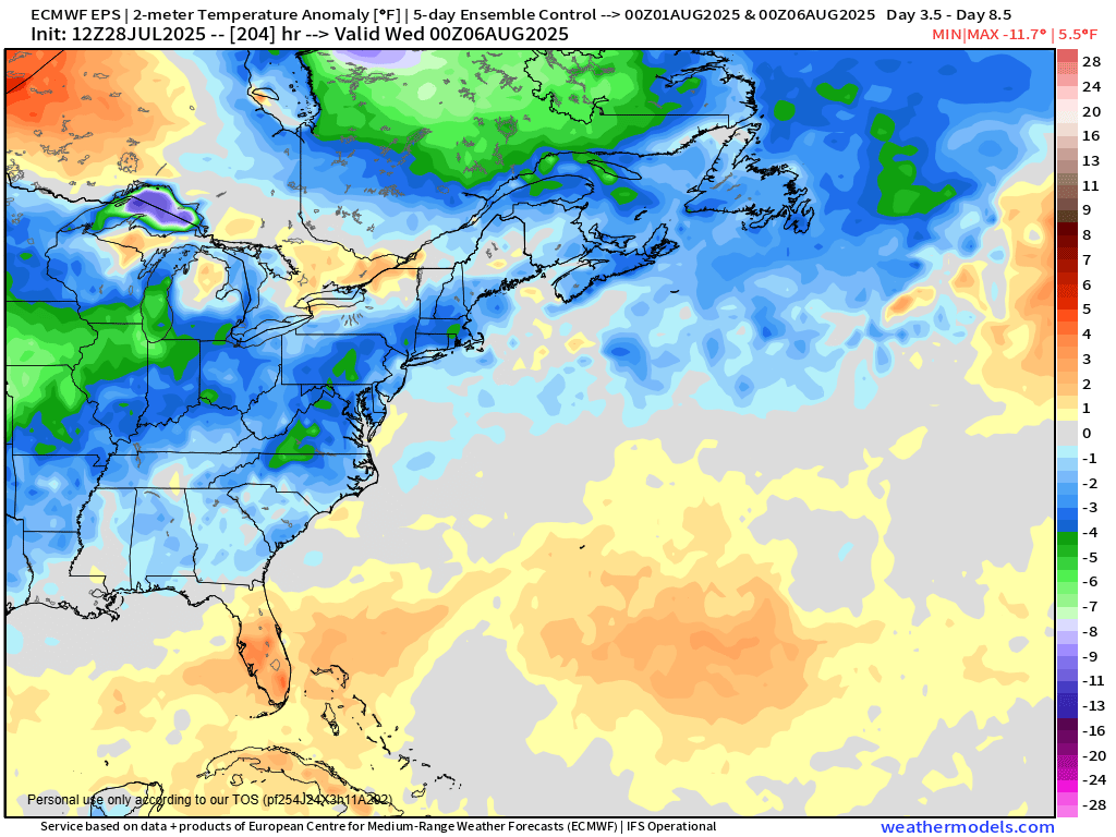
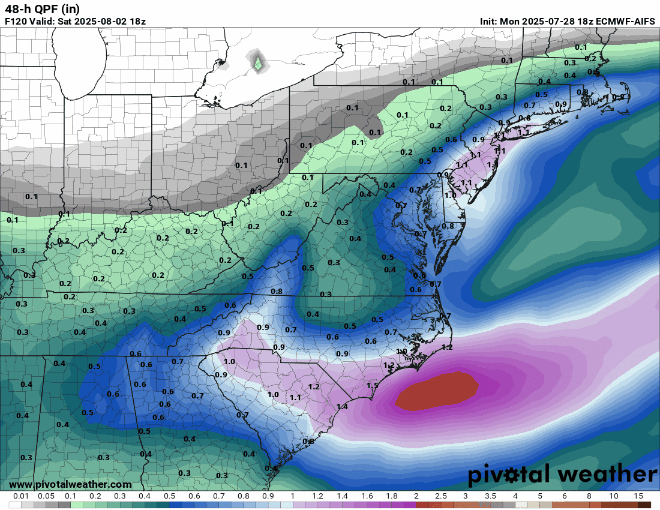
The stormy pattern is expected to continue across the East this weekend, as the NAO is expected to turn negative again, and a large trough of low pressure will settle into the Northeast. After a couple of hot and humid days for the first half of the week, a strong cold front will cross the region late Wednesday and Thursday before stalling out across the Mid-Atlantic states. Behind the front, temperatures will be as much as 5-10 degrees below normal for the end of the week and into the start of next week.
Much cooler weather will settle into the Eastern half of the nation this weekend. Image provided by Weathermodels.com.
Along with the cooler weather, the potential exists for more heavy rain and flooding in parts of the Mid-Atlantic states and Northeast. As that front stalls out, a wave of low pressure will ride along it Thursday into Friday. With plenty of moisture in place in the tropical atmosphere south of the front, the wave of low pressure will produce heavy rain and thunderstorms. Some models show the potential for 3-6 inches or more of rainfall in spots in the span of 24-36 hours. Where the heaviest rain falls will be determined by where the front stalls out and the wave rides along it, which is still uncertain at this point.
Models are showing the potential for some heavy rain in the Northeast and Mid-Atlantic at the end of the week. Images provided by Pivotal Weather.
This pattern has the potential to produce other issues as we head deeper into the summer. The tropics have been mostly quiet thus far, but we’re approaching the time of year when activity ramps up. The bulk of storms in the Atlantic form between mid-August and mid-October. While many storms will end up recurving and heading out to sea before impacting the United States, an East Coast threat becomes a little more likely with an upper-level trough of low pressure in the Midwest or near the Appalachians.
The Pacific continues to grab the headlines, but the Atlantic is getting active as we get closer to the peak of the season.
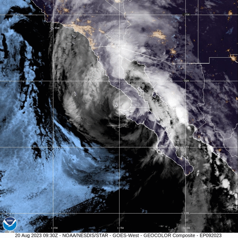
Hurricane Hilary has been downgraded to a Tropical Storm as it continues northward very close to the coast of the Baja California peninsula. As of 11am EDT, Hilary was centered about 220 miles south-southeast of San Diego, moving toward the north-northwest at 25 mph. Maximum sustained winds are near 70 mph. Tropical Storm Warnings remain in effect for northern portions of the Baja California peninsula, as well as the southern California coast from the Mexican border northward to Point Mugu, including Catalina Island.
Satellite loop of Tropical Storm Hilary. Loop provided by NOAA.
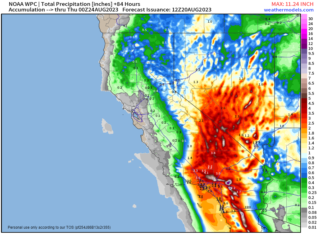
Hilary is expected to continue weakening today as it passes very close to the Baja coastline and into southern California. Hilary will produce gusty winds and storm surge along the coast, with a few tornadoes possible across parts of the Southwest, but heavy rain and the resultant flooding are the most significant threat with this storm. Rainfall totals of 3-6 inches are likely across many locations in southern California and Nevada, with some totals in excess of 10 inches possible. In some of the desert locations, including Death Valley, this is more rain than they normally receive in an entire year. Widespread flooding is likely, including the San Diego, Los Angeles, and Las Vegas metropolitan areas. As Hilary continues to push northward and weakens, heavy rain will spread across the Great Basin, and Inland Northwest, with rainfall totals of 1-3 inches possible, likely producing some flooding in these areas as well.
Very heavy rainfall is expected across California and Nevada over the next few days. Image provided by Weathermodels.com
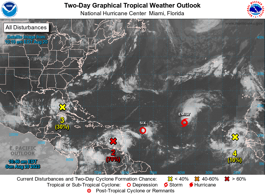
In the Atlantic, Saharan Dust has suppressed activity for the past few weeks, but now that it has moved out, there are several areas of interest, including a pair of storms.
The Atlantic has become quite active over the past few days. Images provided by the National Hurricane Center.
Tropical Storm Emily has developed about 1000 miles west-northwest of the Cabo Verde Islands, moving toward the west-northwest at 10 mph. Maximum sustained winds are near 50 mph. Emily is expected to continue toward the west-northwest for the next day or two, but conditions will become increasingly hostile, with wind shear increasing over the next few days. This will result in steady weakening of Emily, with it likely become extratropical on Monday or Tuesday. After that it will turn toward the northwest and north, heading out into the open waters of the Atlantic, without impacting any land areas.
Satellite loop of Tropical Storm Emily. Loop provided by Tropical Tidbits.
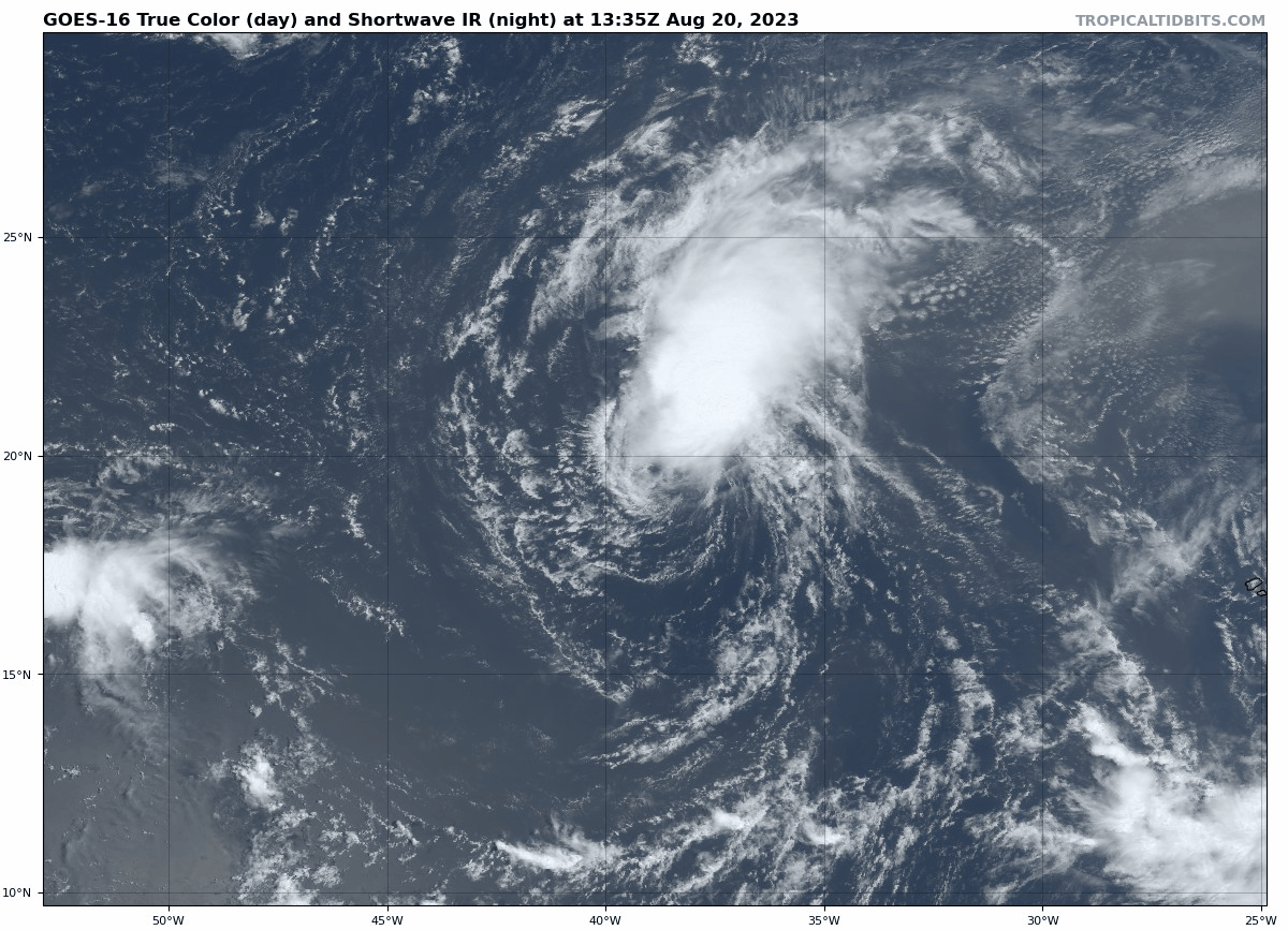
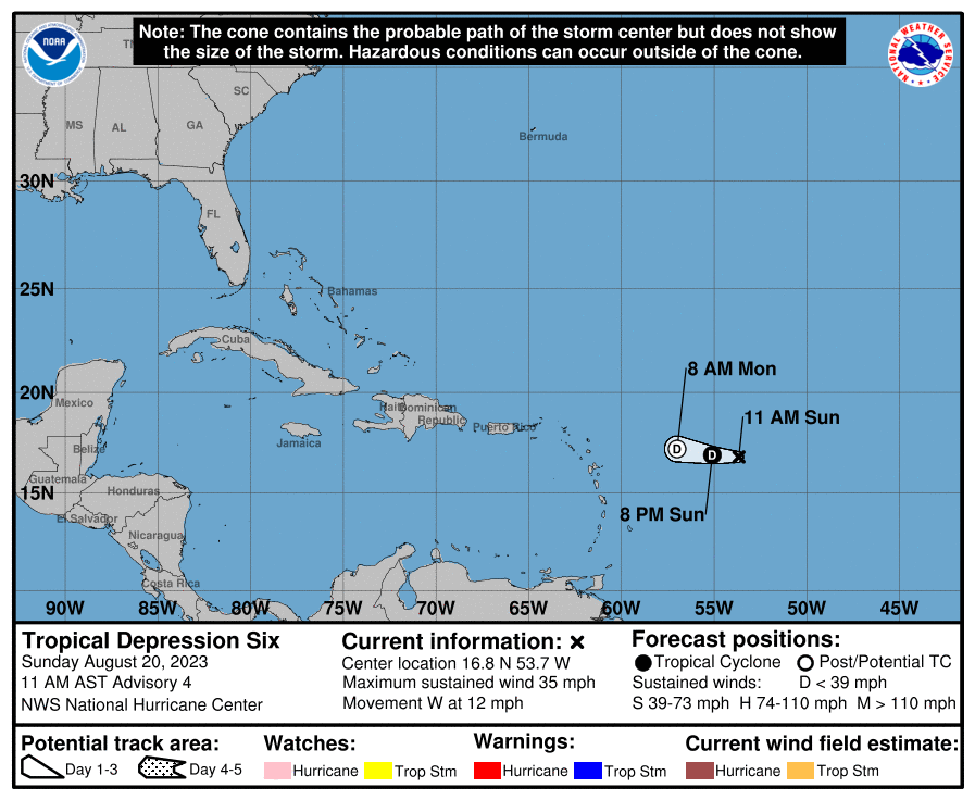
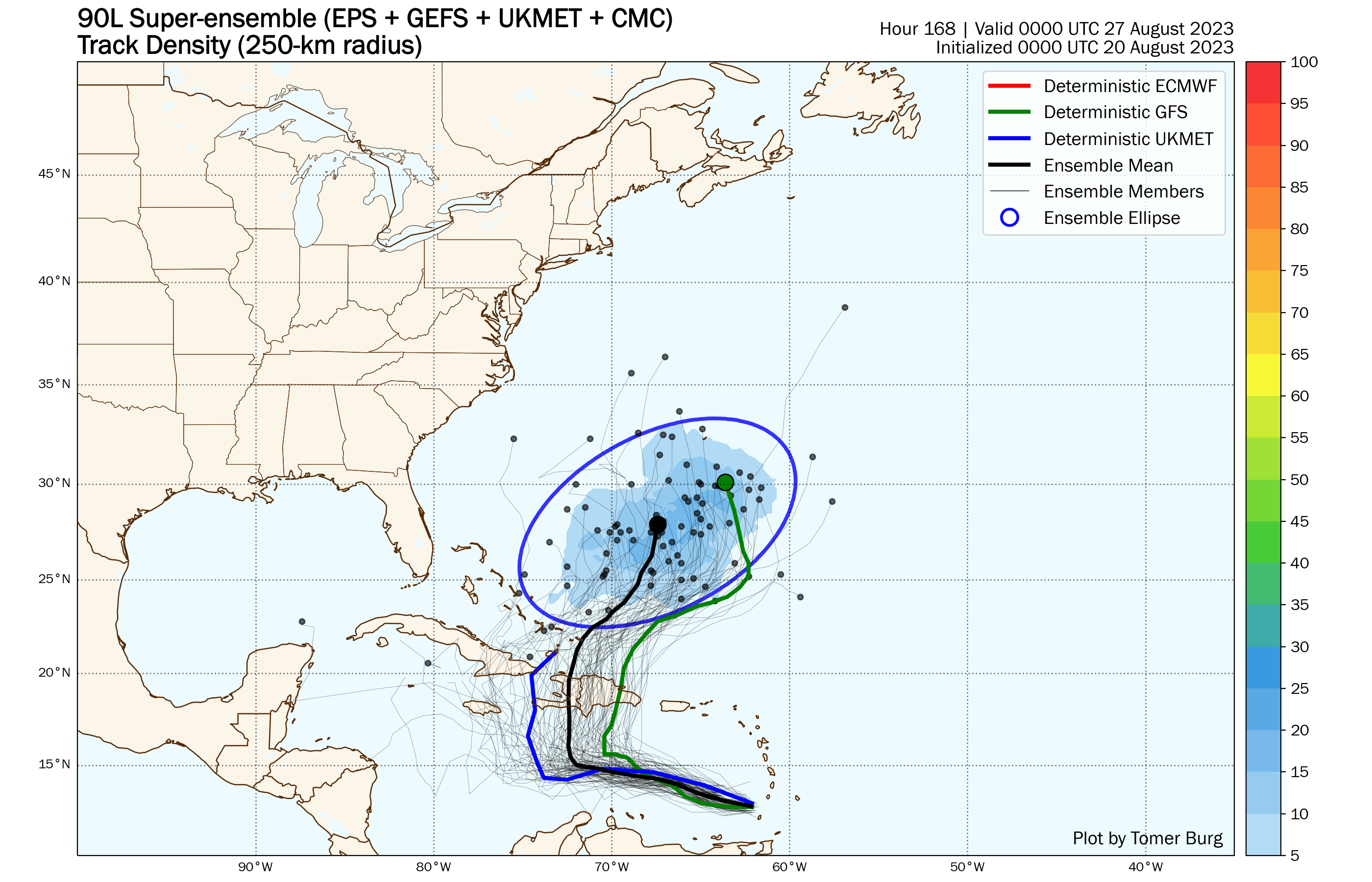
Tropical Depression Six is barely hanging on as an organized system about 625 miles east of the Northern Leeward Islands. Top winds are near 35 mph, and it is moving toward the west at 12 mph. Wind shear is ripping this system apart, and it is expected to dissipate over open water later today or tonight.
Forecast track for Tropical Depression Six. Image provided by the National Hurricane Center.
Another area of low pressure is moving across the southeastern Caribbean Sea this afternoon, producing numerous showers and thunderstorms across the eastern Caribbean. It should continue toward the west-northwest for the next day or two, and conditions are favorable for it to continue to develop. Reconnaissance aircraft are scheduled to investigate this system during the afternoon to check on the structure and strength of the system. It will continue to produce heavy rain and gusty winds across the northern and eastern Caribbean for the next few days, but it should turn more toward the north early this week, which will increase the threat to some of the islands, depending on when the turn occurs. Right now, it looks like Hispaniola will have the biggest threat, but this is predicated on when (or if) that turn occurs. It should eventually move north of the islands, possibly near the Turks and Caicos Islands, before heading out into the Atlantic. Once into the open waters of the Atlantic, it could become a potent storm system, but again, this is dependent on what it does in the next few days first.
Ensemble forecast tracks for the system in the eastern Caribbean. Image provided by Tomer Burg.
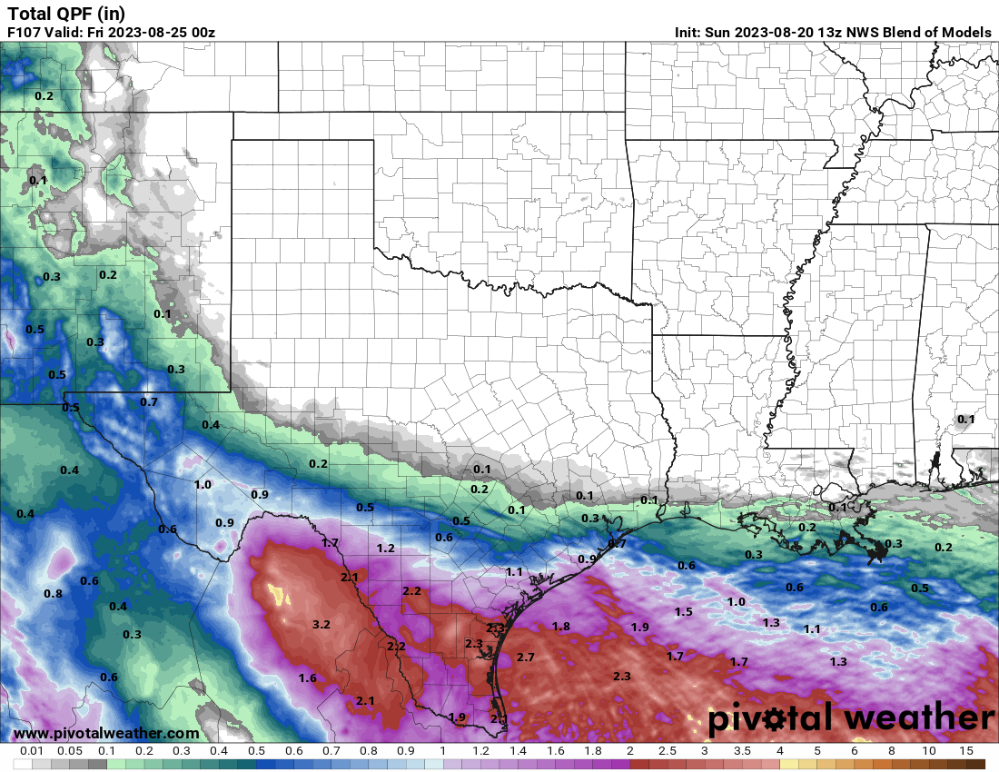
An area of low pressure that brought heavy rain and thunderstorms to the Bahamas and southern Florida has moved into the Gulf of Mexico this afternoon. It is expected to continue westward across the Gulf over the next few days, with some development possible. It could become a tropical depression toward midweek before approaching the Texas coastline. Whether it develops or not, it should bring some much-needed heavy rain to parts of central and southern Texas later this week, helping to not only put a dent in the ongoing drought in the region, but also provide some relief from the heat.
A system will bring much needed rainfall to parts of Texas this week. Image provided by Pivotal Weather.
Yet another tropical wave has moved off the African coast and into the eastern Atlantic. Conditions will be favorable for development over the next several days, and it could become a tropical depression later this week. If it does develop, it is expected to remain over open water, with no impact to land areas through at least next weekend.