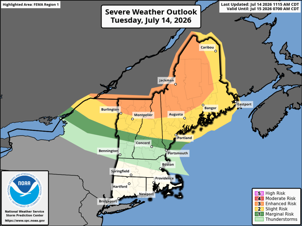
Severe weather doesn’t often make its way to the Northeast to the level that other regions of the country see. When it does, however, it generally comes from one of two directions, from the south along the coast, or from the northwest in southern Canada. The severe weather moving through today and tonight of July is one case of weather coming from the northwest.
Severe Weather potential for the Northeast on July 14th, bringing a risk of tornadoes, wind, and hail to the region. Image provided by NOAA
Weather from the northwest is generally hindered by a lack of humidity, as the further northward you move, the less available moisture there is. The less moisture, the less available total energy there is for storms to form, whereas weather from along the coast generally is limited by the ocean as systems leave New Jersey and pass over both the ocean and Long Island before impacting parts of New England.
Relative humidity from Tuesday the 14th to Wednesday the 15th. Loop provided by Weathermodels.com
Wildfires also play a part in this, as the smoke from them gets high into the atmosphere, injecting drier air, but they can also promote storm formation if particulate that is released by them manages to mix with more moist air. Wildfires in Ontario are the source of the smoke for the next few days.
Canadian wildfires lifting dry air and smoke and dry air into the atmosphere, hindering ground heating needed to form significant storms. Loop provided by Weathermodels.com
For the current storms moving through, wind, hail, and tornadoes are all expected to be on the stronger side when they occur. Most of the severe threat is limited to areas that are generally less populated in northern Vermont, New Hampshire and Maine, though this does not mean that severe weather won’t move into more populated regions, and a system could move through southern New Hampshire overnight on the 14th into the 15th, bringing showers and strong winds, with the potential for hail and tornadoes as the night progresses.
Storms moving through New England on the 14th overnight in to the 15th. Loop provided by Tropical Tidbits
Cooler and drier air will move into New England on July 15 behind a cold front.
After a calm weekend following the severe weather the week of June 7th, Severe weather returns to the Midwest this week.
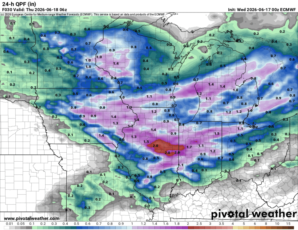
Rainfall totals in the Midwest on June 17th, with most of the region getting between 1 and 2 inches of rain. Image provided by Pivotal Weather
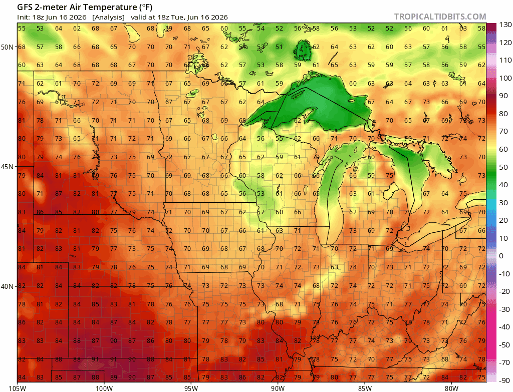
A low pressure system is sweeping through the Midwest along the jet stream, meeting warm Atlantic moisture as it does, bringing severe thunderstorms, wind, hail, and tornadoes as they collide. Fortunately temperatures are expected to remain cool in the Midwest, with highs in the 60s and 70s, and lows in the 50s between the the 17th and the 20th.
Temperatures in the Midwest to remain in the 60s and 70s from the 17th to the 20th. Loop provided by Tropical Tidbits
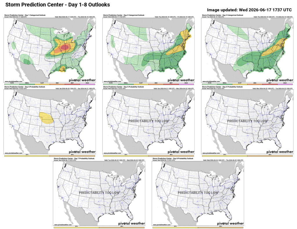
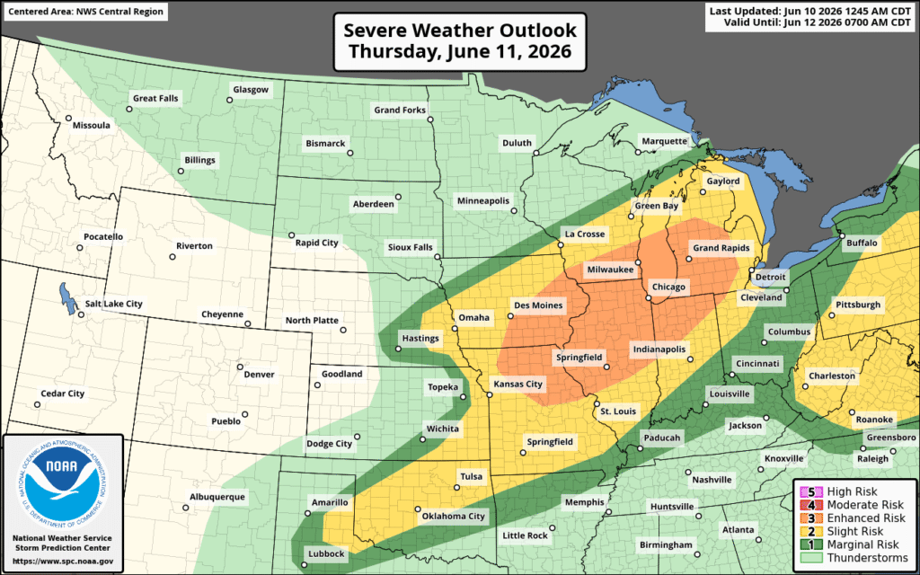
Severe weather, including tornadoes, hail, wind, and thunderstorms, are expected to remain in the region today, moving into the Northeast on Thursday.
Severe weather remains in the Midwest on the 17th before moving east. Image provided by Pivotal Weather
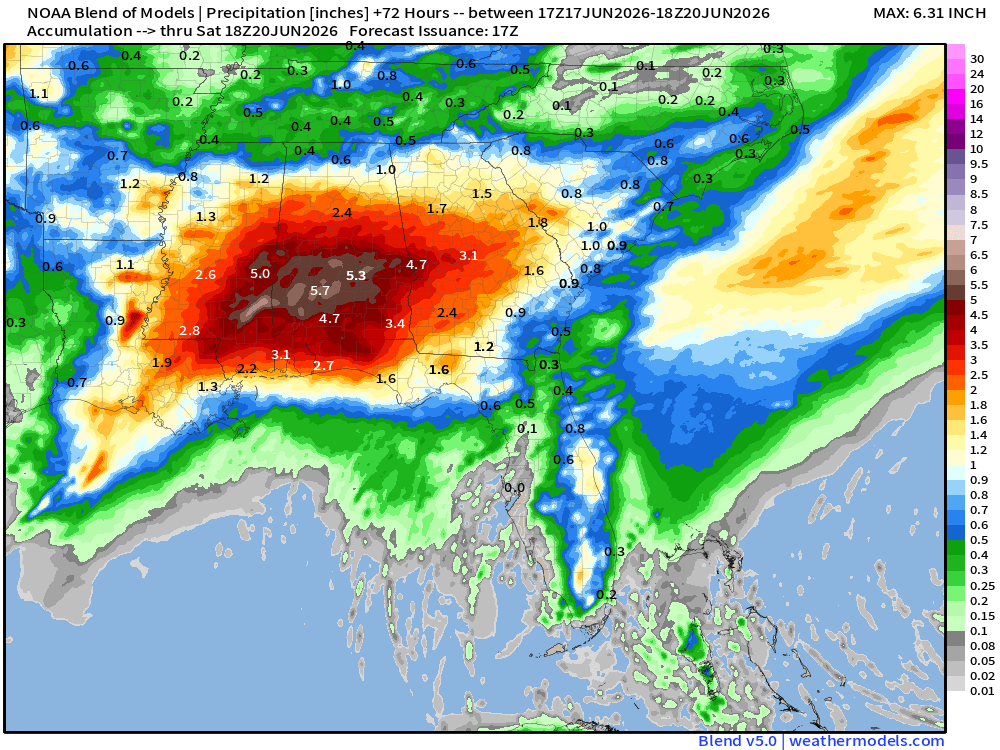
In the South, a large region of moisture is expected to bring excessive rainfall to to the area as it moves inland before combining with the system in the north. Southeast Mississippi and Southern Alabama are expected to get up to 5 or 6 inches of rain from the night of the 17th to the 20th with strong winds and flash flooding as the main risk, and a slight chance for tornadoes.
Tropical Storm Arthur to bring up to 6 inches of rain in southern Mississippi and Alabama from the 17th to the 20th. causing wind damage and widespread flash flooding. Image provided by Weathermodels.com
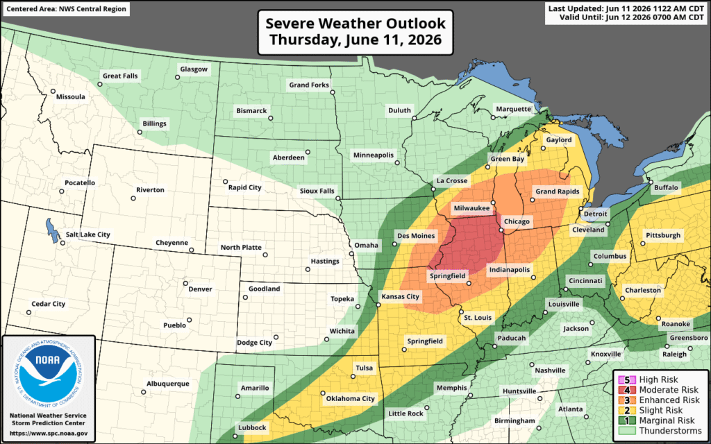
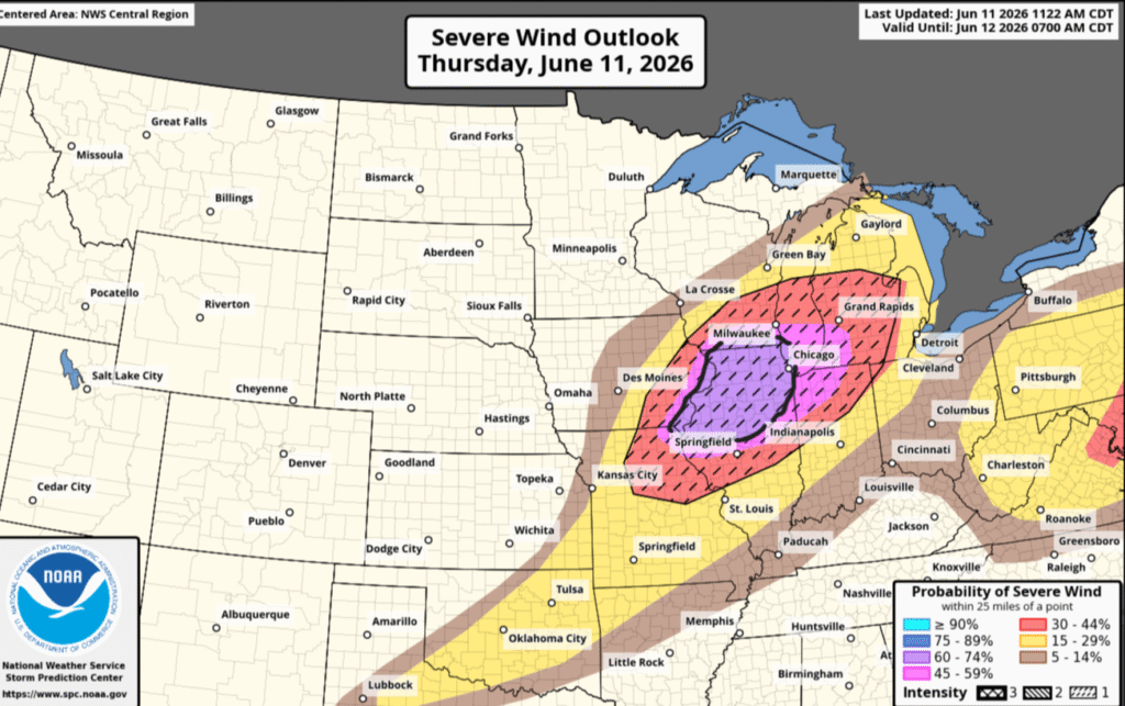
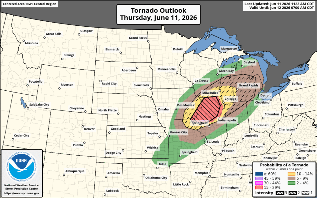
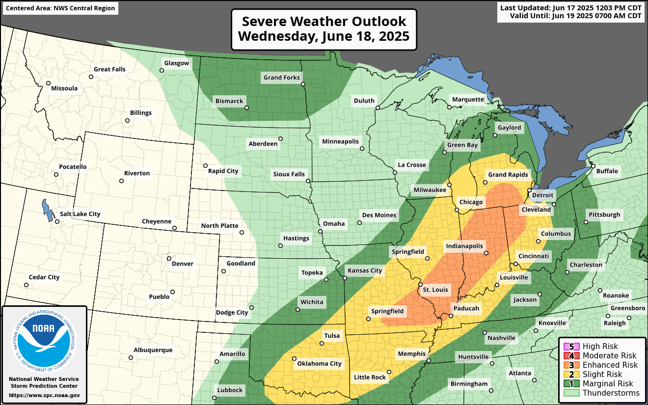
Severe Weather is continuing today and tonight in the Midwest, with a moderate risk of severe weather, up from yesterday’s enhanced risk. There is also an enhanced risk for both wind and tornadoes, with Northern Illinois and Southeastern Iowa under the greatest risk.
Severe weather continues with an upgraded risk in the Midwest. Image provided by NOAA
Starting in the Midwest, and the region of moderate severe weather, wind and tornadoes are the greatest threats. Northern Illinois is currently at the highest risk, with a 60-74% chance of destructive winds at any point within 25 miles of a location in that region. Northwest Indiana has a 45-59% risk within the same 25-mile range. The hatched region indicates elevated risk of 75 mph gusts, up from 50 mph in non-hatched areas, from downbursts or microbursts that can down trees or power lines, tear shingles off of roofs, and potentially destroy smaller and less structurally sound buildings.
Wind risk for the Midwest, with a hatched (75mph risk) covering much of the region. Image provided by NOAA
Northern Illinois has the highest risk of tornadoes, with a 15-29% chance of a tornado within 25 miles of any point in the dark red-shaded region. This region also has an elevated risk of a tornado being at least EF3, indicated by the left-leaning hatched region. Michigan, Missouri, Iowa, and Wisconsin have a 10-14% risk of a tornado, again within 25 miles of a point in the yellow shaded region. The dashed-hatched region indicates an elevated risk of a tornado being at least EF2 and extends across Michigan beyond the 10-14% risk. Tornadoes include all of the high-end wind threats and now also include potentially flipped vehicles or significant damage to well-built structures. Hail is also likely, with northern Illinois and northeastern Missouri potentially seeing 2-inch hail.
Tornado risk is centralized in Northern Illinois. The left-tilted hatched region represents a high potential of EF3 tornadoes, and the dashed EF2. Image provided by NOAA
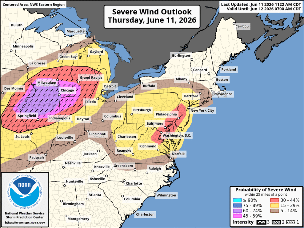
Moving over to the northeast, the greatest threats in this area tonight is wind and hail. Washington, D.C., Baltimore, and Philadelphia are at the highest risk, with a 30-44% chance of severe wind, while New York is just outside it in the 15-29% range. While coastal cities are used to strong sea breezes being amplified through narrow urban corridors, severe wind generally blows in a different direction than expected and is stronger than a simple sea breeze. Severe Hail is also expected, with a 5-14% chance of quarter-sized hail across the northeast.
Wind risk in the Eastern US is centralized around coastal cities, though it extends across Pennsylvania. Image provided by NOAA
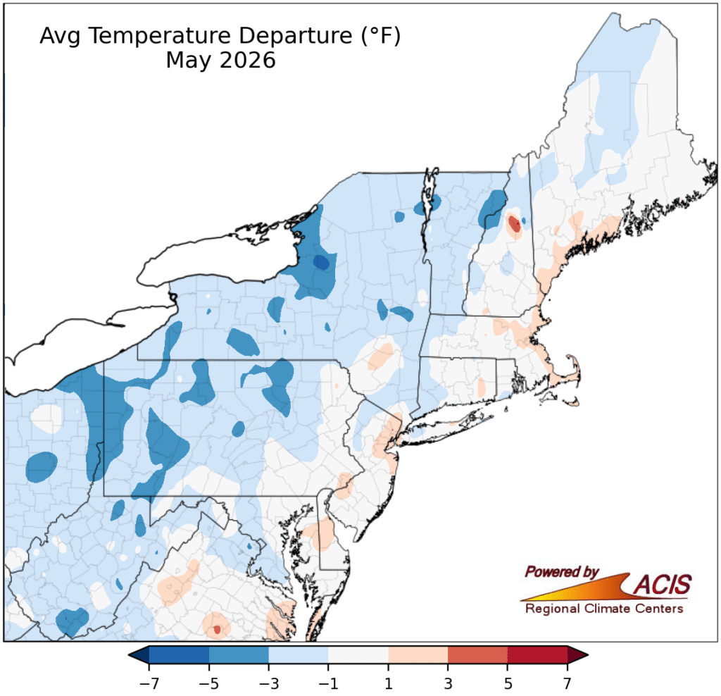
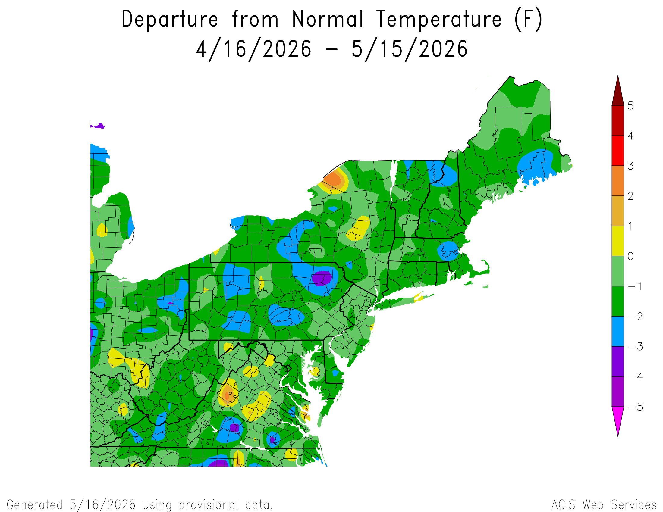
May 2026 was cooler than average for much of the Northeast, but the past week or two have seen warmer temperatures, though that might change this weekend.
Cooler temperatures were the norm for May 2026, with most of the region being at or below average temperature. Image provided by the Northeast Regional Climate Center.
A back door cold front is moving through the northeast, bringing short relief from the heat, but a ridge of high pressure in the north central US is giving way to severe weather expected to move across the northern US. Temperatures in the 80s and 90s are expected until the weekend, as a large area of low pressure follows the severe weather, bringing highs in the 60s to 70s for the East, and potentially into the 50s in the Central US.
A High pressure ridge over the Central US gives way to severe weather, followed by lower pressure over much of the northern US. Loop provided by Tropical Tidbits
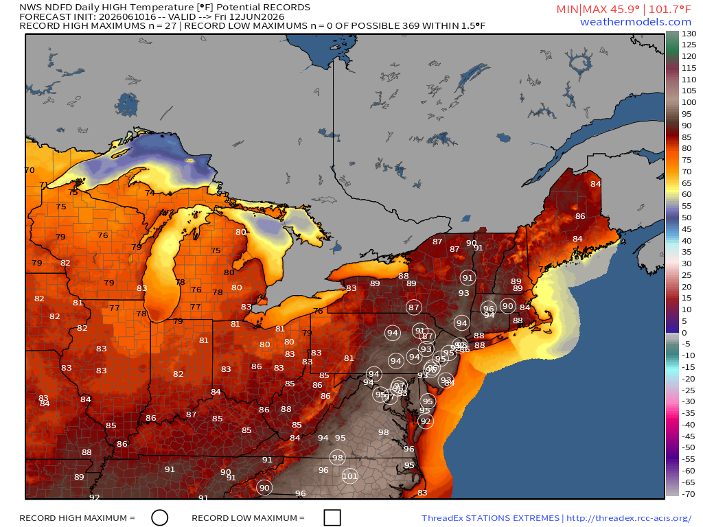
The warmest weather is expected on Thursday and Friday, as the high pressure sets up offshore, bringing warm humid air up the coast. Records could be set once again along the I-95 corridor, with temperatures well into the 90s, potentially reaching triple digits in North Carolina. Water temperatures along the coast have warmed up, with temperatures in the 50s and 60s along New England and into the 80s along the Southeast and Gulf Coast, providing some relief for people heading to the beaches. Cool temperatures should return over the weekend as a cold front moves through the region.
Record highs are expected through eastern US on Friday as a high pressure ridge sets up off the coast. Image provided by Weathermodels.com
While the Eastern US can expect severe weather on Thursday and Friday, most of the Midwest is looking at severe weather continuing into Thursday.
Severe weather is likely to continue in the Central US Wednesday and Thursday, with the East Coast expecting some on Thursday and Friday. Image provided by Pivotal Weather
A low pressure trough pushing through a high pressure ridge promoted development of severe weather Tuesday night, which is expected to continue into Wednesday night and Thursday. Strong to severe thunderstorms are likely from the Central Plains northeastward into the Great Lakes, with an area developing along the East Coast on Thursday. Today, much of the Midwest can expect severe weather to continue, bringing strong winds, hail, and potentially tornadoes to the region, with a stronger wind threat Thursday, alongside continued hail and tornado risks.
The North Central Plains and Upper Midwest are looking at several rounds of storms tonight into Thursday. Image provided by NOAA.
As the system moves through, high pressure builds in behind it, bringing cooler temperatures and calmer weather. The East Coast can expect cooler weather on the weekend as the high makes its way to the region.
Much of the Spring has featured an upper-level trough of low pressure across the Northeast, but that will change this weekend.
Temperatures have been below normal across most of the Northeast since mid-April. Image provided by the Northeast Regional Climate Center.
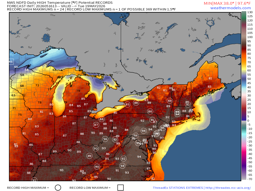
A persistent trough of low pressure has kept temperatures below normal across the Northeast for much of the past several weeks, but a ridge of high pressure will build in this weekend, both at the surface and aloft, resulting in some much warmer weather. Temperatures will get well into the 70s and 80s this weekend, with some spots topping 90. A weak backdoor cold front will bring cooler weather to parts of New England Sunday night and Monday, with temperatures only in the 60s and lower 70s, especially near the coastline, but inland areas, especially outside of New England, should get well into the 80s and lower 90s.
A ridge of high pressure will build into the East over the next few days. Loop provided by Tropical Tidbits.
The warmest weather is expected Tuesday and Wednesday with high pressure anchored offshore. Southwest winds will bring warm and increasingly humid air to much of the East Coast, with high temperatures well into the 80s and 90s, likely setting records in many locations along the Interstate-95 corridor. Anyone heading to the beach for relief should remember that the water is still relatively cold as it is early in the season. Water temperatures are only in the 40s and 50s off the coast of New England, and 50s and 60s off the Mid-Atlantic coastline. A strong cold front will bring an end to the heat later Wednesday, possibly with some strong to severe thunderstorms accompanying that front.
Record highs are possibly in many locations in the Northeast Monday through Wednesday. Image provided by Weathermodels.com
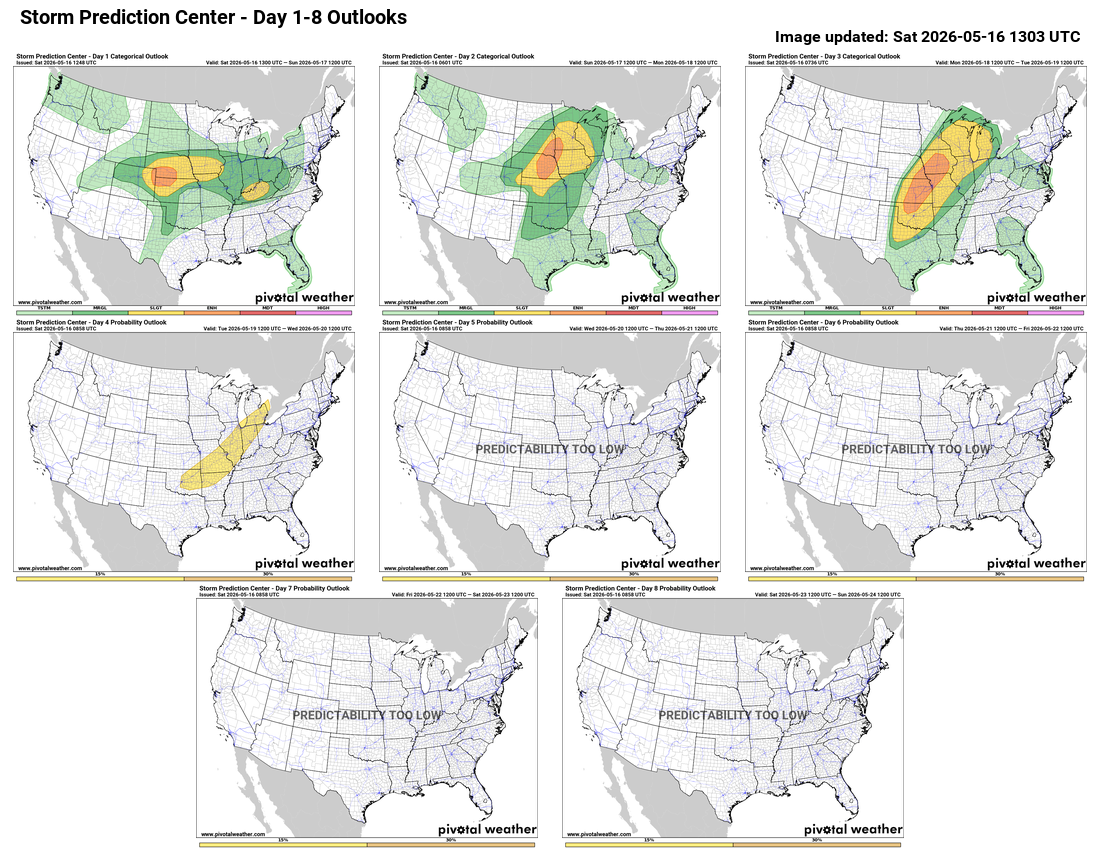
While areas in the East Coast are looking at the potential for severe weather on Wednesday, many spots in the Plains states and Midwest could see several waves of severe weather over the next few days.
A multi-day severe weather event is likely across the nation’s mid-section. Image provided by Pivotal Weather.
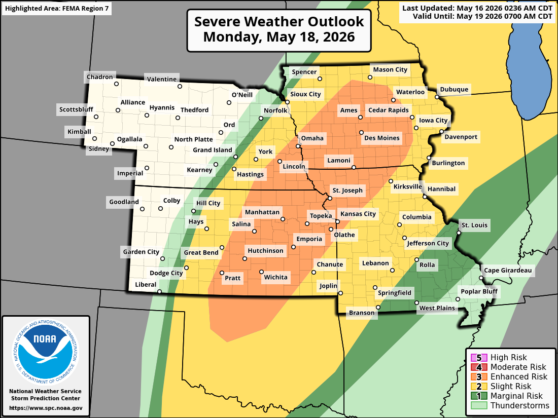
Low pressure developing in the southwestern Plains states will only slowly move northeastward over the next few days. Strong to severe thunderstorms are likely this afternoon and evening from the Central Plains eastward into parts of the Mississippi and Ohio Valleys. Areas from eastern Colorado across Kansas and Nebraska and into Iowa are under the gun today, with some of the stronger storms likely producing damaging winds, large hail, heavy downpours, and tornadoes. As the system slowly moves out of the Plains states and toward the Upper Mississippi Valley on Sunday, the focus of severe weather will shift into parts of the Northern and Central Plains and Upper Midwest, especially from Nebraska into Iowa and parts of Minnesota. Once again, storms may produce strong winds, large hail, heavy downpours, and tornadoes.
The Central Plains will be under the gun for multiple rounds of severe weather over the next few days. Images provided by the Storm Prediction Center.
By Monday, as the system moves into the Great Lakes and drags a strong cold front behind it across the Plains states, a very active day is expected from northern Texas northeastward to Michigan. Widespread strong to severe thunderstorms are likely, but the area from northern Oklahoma to Iowa is where the strongest storms are expected, with many supercells producing large hail, damaging winds, and numerous tornadoes. As the front moves eastward the threat for severe weather on Tuesday will shift to parts of the Great Lakes and Ohio Valley, as well as the southern Plains, and then potentially to parts of the East Coast and Tennessee Valley on Wednesday.
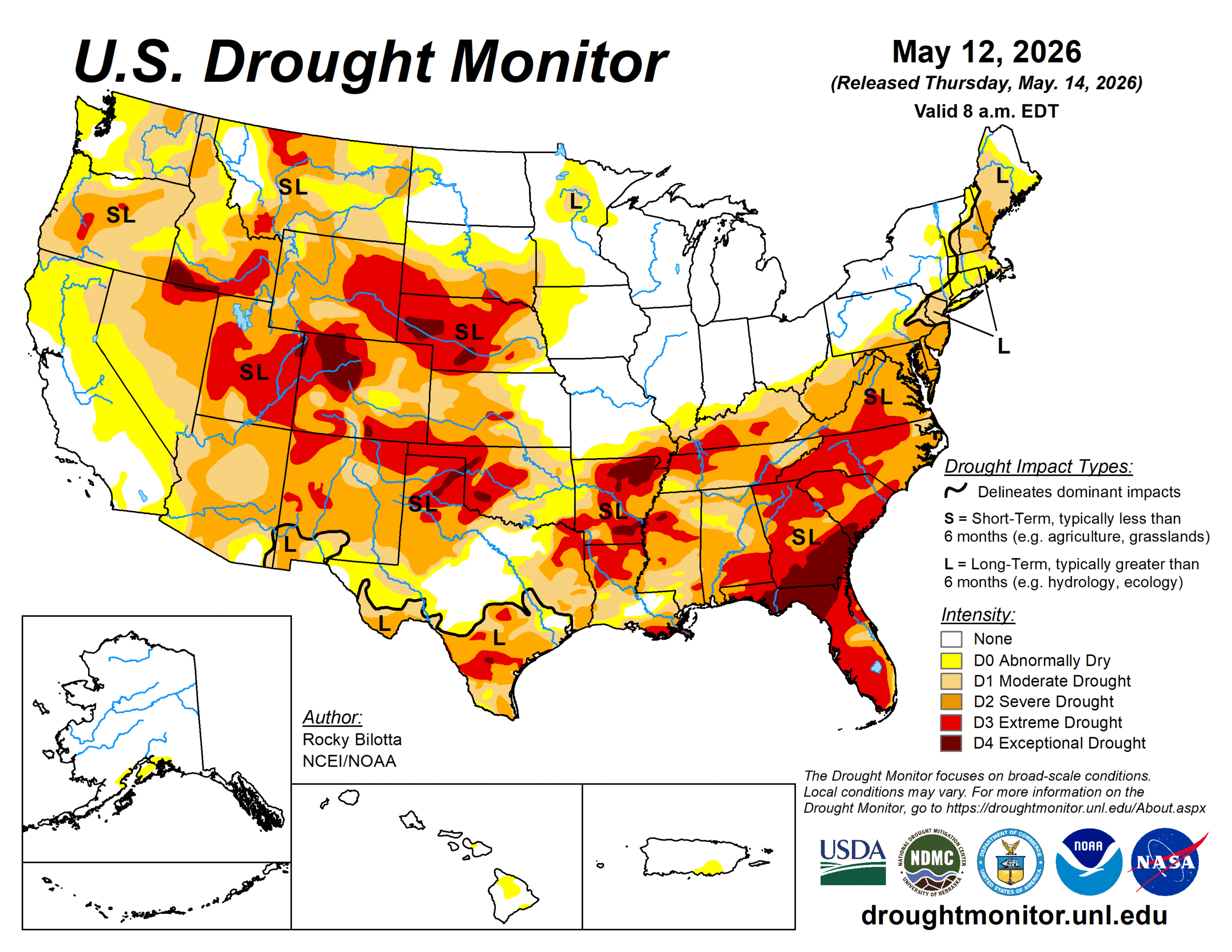
Drought conditions continue across a large portion of the nation. Image provided by the National Drought Mitigation Center.
There is a bit of a silver lining to this, as widespread rainfall, some of it heavy, is likely across a large portion of the nation’s mid-section. Much of this region, especially the Central and Southern Plains, is in the middle of a significant drought, so any rain is beneficial, and will help put a dent in the drought, especially as the growing season gets underway.
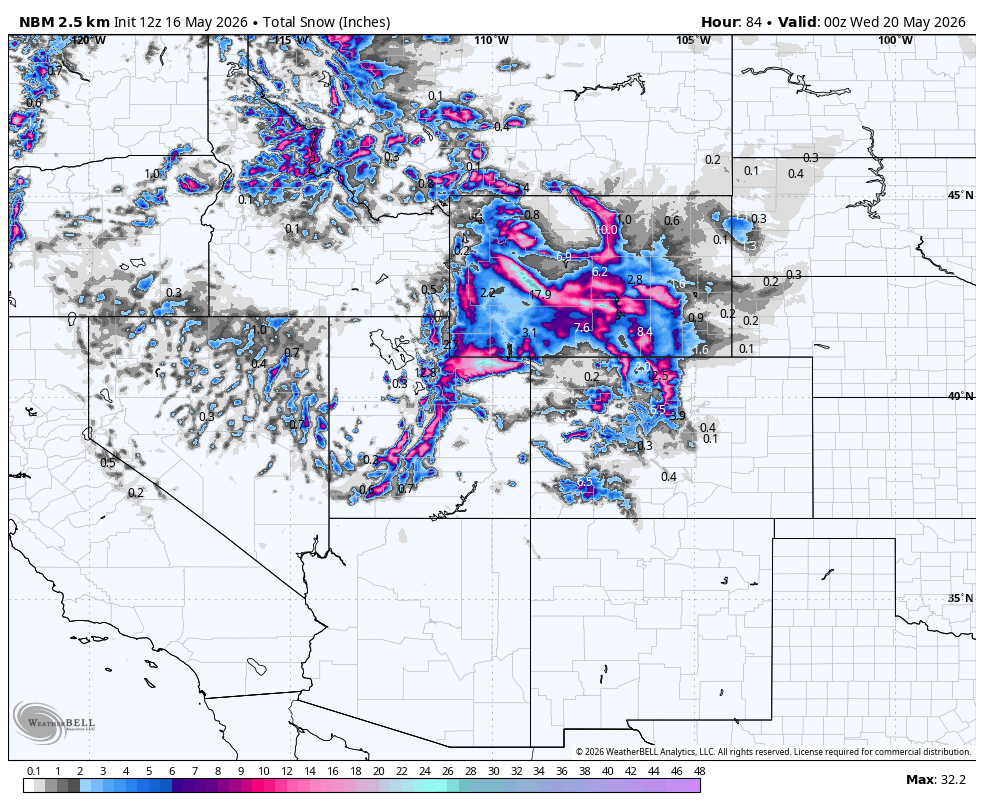
Another late-season snowstorm is possible across parts of the Intermountain West and the Rockies late this weekend and early next week. Image provided by WeatherBell.
Behind the cold front, much colder air will settle into the Plains states and the Rockies. Some record lows are possible both Monday and Tuesday morning as temperatures drop into the 20s and 30s. At the same time, another low pressure system will be moving across the Great Basin, and as it encounters the colder airmass, snow is expected across the mountains, with much-needed rain at the lower elevations. Winter Storm Watches have already been issued for parts of Wyoming for late Sunday and Monday, and more are likely to be issued for parts of the region, including Utah and Colorado, later today. Some of the mountains could pick up as much as 1-2 feet of snow, possibly even more in spots. Some flakes could mix in with the rain in the Denver area Monday and Monday night, with accumulations likely in the foothills west of the city. After a fairly dry winter, the snow is welcome, as it will help with spring runoff.
August typically brings a range of weather conditions to the United States, from excessive heat to tropical systems and everything in between. As we move into the middle of the month, we are beginning to see this play out.
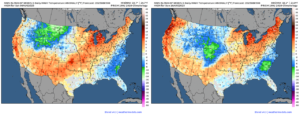
This weekend will bring dry and warm weather to much of the country. Many areas are expected to experience above-normal temperatures on Saturday. In contrast, others, including the Mid-Atlantic, Southeast, Intermountain West, and North-Central Rockies, are expected to experience below-normal temperatures. A cold front moving into the center of the country on Saturday will allow temperatures to dip below normal across the Central Plains on Sunday. Temperatures will also shift above normal on Sunday in interior areas of the Pacific Northwest as high pressure builds in across the region.
Temperatures average mainly above normal through the weekend across much of the country, with below normal temperatures in the Intermountain West, Southeast, and Mid-Atlantic. Images provided by Weathermodels.
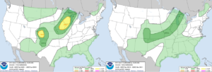
A cold front moving across the central United States will bring a marginal risk of severe weather to the Upper Great Lakes and Central Mississippi Valley, as well as the Central and Southern Plains, through the weekend. The highest risk for severe storms will be on Saturday, with a slight risk of severe weather across southwestern Wisconsin, southeastern Minnesota, northeastern Iowa, and eastern Colorado.
There is a slight risk of severe weather on Saturday for the Upper Midwest and eastern Colorado, with a marginal risk through the weekend from the Upper Midwest to the Southern Plains. Images provided by the Storm Prediction Center.
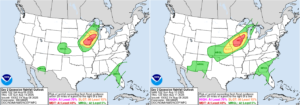
The cold front will also bring heavy rainfall to the Upper Midwest. There is a moderate risk of excessive rainfall across southwest Wisconsin, eastern Iowa, northwestern Illinois, and northeast Missouri on both Saturday and Sunday, with a slight risk extending from southern Wisconsin to eastern Kansas. A stationary front will continue to produce rain and thunderstorms across much of the Southeastern United States, with a marginal risk of excessive rainfall on both days. Meanwhile, in the Southwest, monsoonal moisture will bring showers and thunderstorms to the region with a marginal risk of excessive rainfall for both Saturday and Sunday.
The Upper Midwest will face the highest risk of excessive rainfall through the weekend, with areas such as the Southeast and Southwest also facing a marginal risk. Images provided by the Weather Prediction Center.
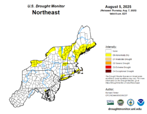
As we move into the beginning of next week, temperatures are expected to rise across the Northeast, with above-normal values anticipated for much of the week. The slow-moving front will bring showers and thunderstorms to the Midwest through the middle of the week before moving into the Northeast toward the second half of the week. The Northeast will see its next potential for rain as this front moves through, ending its dry stretch, which has caused some areas to become abnormally dry across the region.
Areas of the Northeast are becoming abnormally dry as the region continues to see dry conditions. Image provided by the National Drought Mitigation Center.
The stationary front across the south will continue to bring the potential for rain and thunderstorms to much of the region through the end of the week. Areas in the Southwest will also see the possibility of showers and thunderstorms each afternoon as monsoonal moisture remains over the region. Otherwise, high pressure will continue to bring dry weather to the majority of the country.
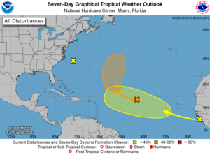
We will also be monitoring tropical development as the week progresses, since the National Hurricane Center continues to monitor areas in the Atlantic Ocean for possible development over the next seven days. Some models have been in favor of tropical development by the end of the week, but also show vastly different solutions for these systems. At this time, it is still too early to determine whether these storms will develop, never mind their storm tracks.
The National Hurricane Center is monitoring three areas for tropical development in the Atlantic over the next 7 days. Image provided by the National Hurricane Center.
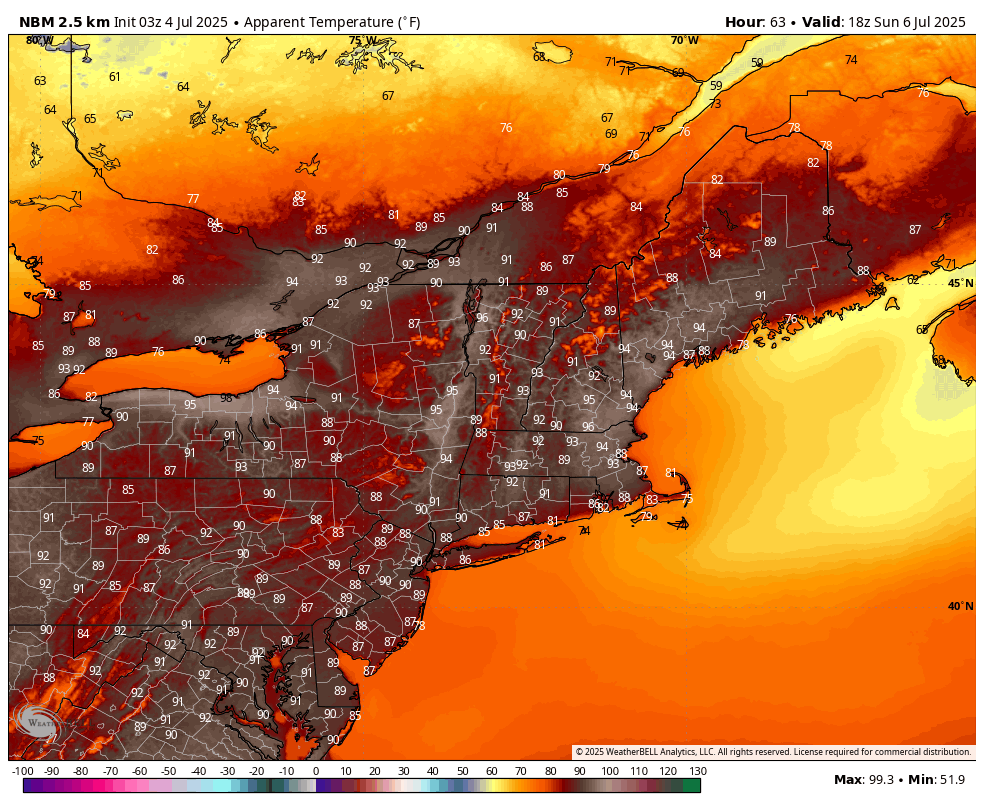
As we begin the Independence Day holiday weekend, high pressure will bring dry weather to many areas of the eastern United States, while places out West could see unsettled weather. A frontal system will move east into the start of next week, bringing showers and thunderstorms across the northern and eastern half of the country. Hot and potentially dangerous temperatures are possible into the start of the week across the Midwest and Northeast. Eyes are on the waters off the Southeast, where tropical storm development is possible around mid-week.
Friday – Independence Day
A cold front that has recently crossed the Northeast will provide perfect weather for the region, high pressure bringing sunshine and lower dewpoints, keeping humidity at a very comfortable level. High pressure will continue to dominate from the Great Lakes to the Gulf Coast, bringing sunshine to most of the Eastern United States.
Much drier air will move into the Northeast for Friday. Image provided by Weathermodels.com
Other areas of the Southeast will see the potential for rain as a low pressure near Florida allows the rain to continue. Remnants of the very short-lived Tropical Storm Barry will also bring the chance for rain and thunderstorms to most of Texas.
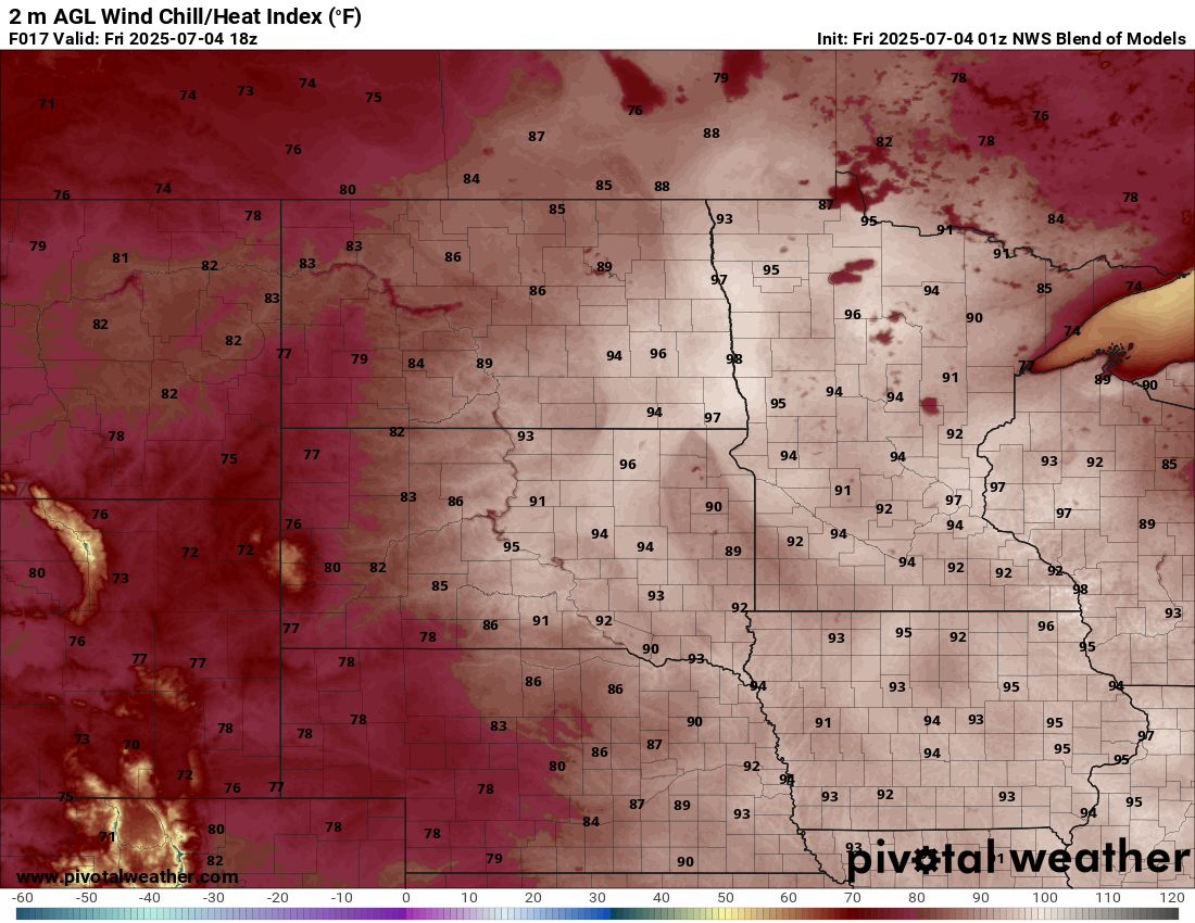
Hot and potentially dangerous temperatures are possible across the Upper Mississippi Valley and Northern Plains ahead of a cold front extending from a low pressure system in central Canada. This frontal system will bring rain and thunderstorms to the region, with a marginal risk of strong to severe thunderstorms.
Heat index Values for Friday across the Northern Plains. Image provided by Pivotal Weather.
Monsoonal moisture will produce showers and thunderstorms across parts of the Southwest, especially during the afternoon. A system in the Northwestern United States will bring showers with a chance of thunderstorms to the Pacific Northwest, Great Basin, and Intermountain West.
Saturday
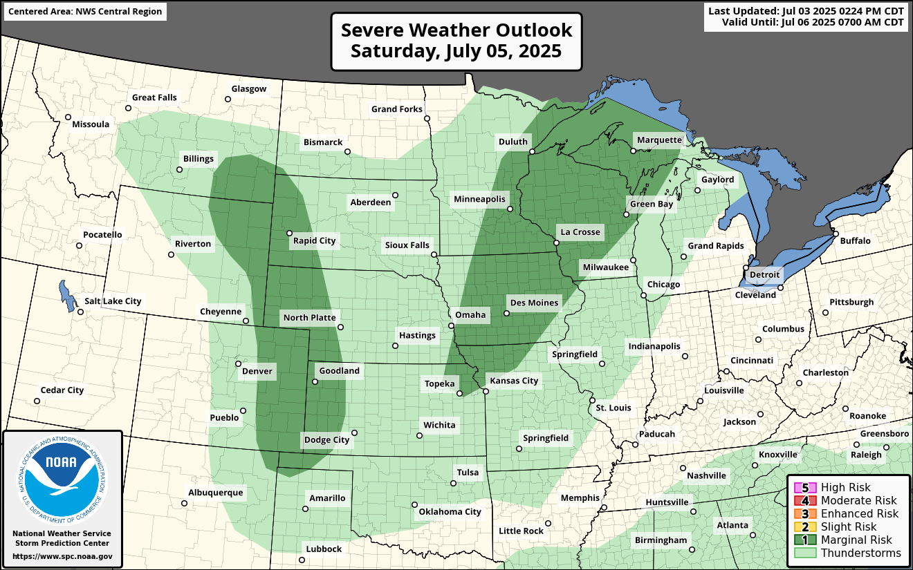
The hot temperatures will progress east as the frontal system moves across the northern United States, the marginal risk of severe weather continues across the Upper Great Lakes while also shifting to the central Mississippi Valley. The front will wrap up into the Central Plains as it converges with a weaker system in the Northwest, with a marginal risk of severe weather in the west-central Plains.
Severe weather outlook for Saturday. Image provided by the Storm Prediction Center.
The low pressure near Florida will bring another day of showers and thunderstorms to the state as moisture from Barry continues to sit over Texas, with more showers and thunderstorms possible.
Monsoonal moisture will allow the potential for afternoon showers and thunderstorms to return across the Southwest.
Sunday
Showers and thunderstorms will begin to taper off across Florida as the low pressure system nearby slowly pulls away from the region and moves up the East Coast, bringing shower and thunderstorm activity into the Mid-Atlantic.
Hot and humid weather will return to the Northeast as the frontal system continues its eastward progression. Showers and thunderstorms are possible from the Great Lakes to the Southern Plains. The weaker system follows behind the main system, bringing the potential for showers and thunderstorms to the Central and Northern Plains.
Heat indices across the Northeast on Sunday. Image provided by WeatherBell.
Monsoonal moisture could potentially bring more showers and thunderstorms to the Southwest.
Monday through Friday
Hot and humid weather will continue across the Northeast on Monday as the frontal system continues its progression east with showers and thunderstorms possible from the Northeast to the Southern Plains. A weaker low pressure system following this system will continue to produce showers and thunderstorms through the Central Plains.
The low pressure system in the Southeast will continue its journey up the East Coast, allowing for the potential of showers and thunderstorms across the Mid-Atlantic. This system will begin to interact with the large frontal system on Tuesday, allowing the front to become stationary across the Tennessee Valley. The stationary front will produce showers and thunderstorms from the Ohio Valley to the Gulf Coast through the end of the week. These two systems will be monitored for tropical system development as they move offshore.
The East will be unsettled with the West turns drier next week. Loop provided by Pivotal Weather.
The smaller low pressure in the Central Plains will begin to weaken on Tuesday, allowing the shower and thunderstorm potential to diminish. Drier weather is expected through the middle of the week before another system develops toward the end of the week, bringing the potential for showers and thunderstorms.
Monsoon moisture will allow for the potential of afternoon showers and thunderstorms each afternoon.
Hot and humid conditions are expected across the eastern half of the nation as we go through the first weekend of summer.
A ridge of high pressure brings heat and humidity to the eastern half of the nation over the next few days. Loop provided by Pivotal Weather.
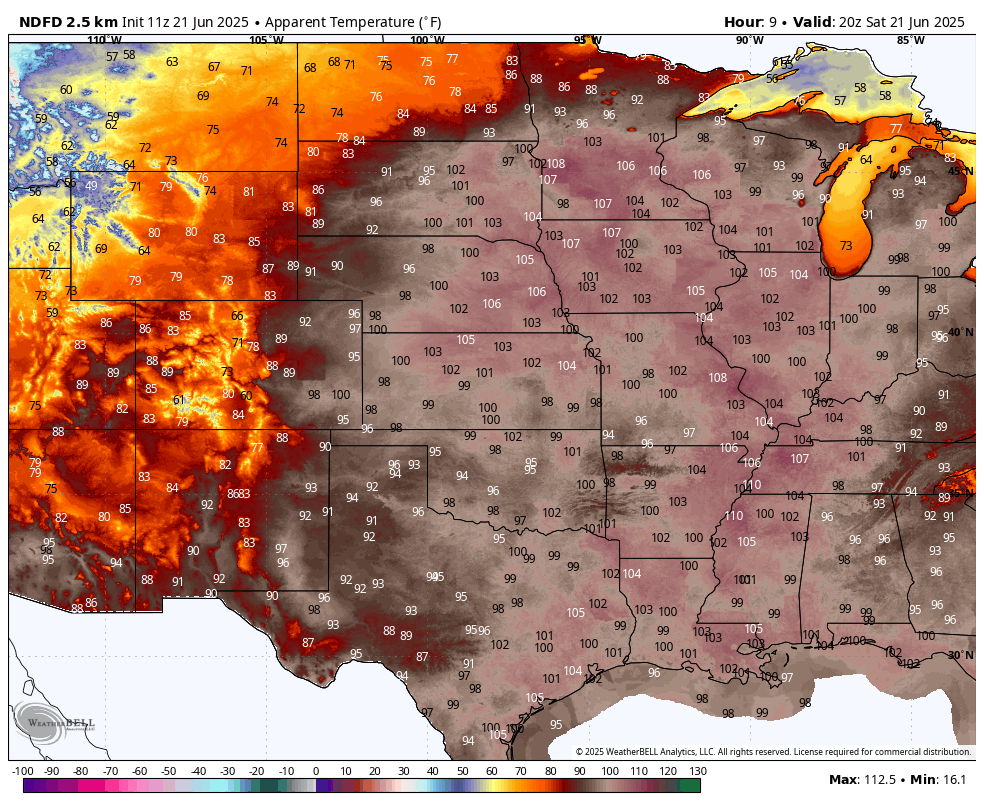
A large ridge of high pressure centered over the Mississippi and Tennessee Valleys Saturday morning will slowly move eastward over the next few days, resulting in hot and humid conditions for a large portion of the nation. The heat and humidity are focused on the Plains States and Mississippi Valley to start the weekend with Heat Advisories and Extreme Heat Warnings in place from the Northern and Central Plains into the Mississippi Valley and the Midwest. High temperatures will reach the 90s in much of this region, with highs topping 100 in parts of the Northern and Central Plains, possibly setting records in a few spots. With dewpoints in the upper 60s and 70s, the heat index will reach 100 to as high as 110 in much of the region. The heat will continue into Sunday, with widespread highs in the 90s and lower 100s expected once again and heat indices in excess of 100, but an approaching cold front will produce showers and thunderstorms during the afternoon and evening, some of which could be strong to severe, bringing relief to the region.
The heat index will top 100 across much of the nation’s mid-section Saturday afternoon. Image provided by WeatherBell.
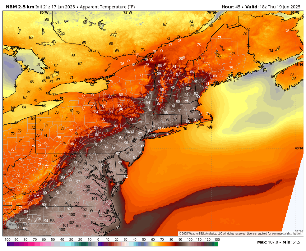
The heat and humidity will shift into the Great Lakes and Northeast on Sunday, with record highs expected in many areas as temperatures rise well into the 90s. Dewpoints will be climbing into the 60s and 70s, resulting in heat indices near or over 100. Heat Advisories and Extreme Heat Watches and Warnings have been issued for much of this region. As we head into the start of the new week, the focus of the heat will shift once again to the heavily-populated Interstate 95 corridor along the East Coast. High temperatures in the upper 90s to possibly lower 100s are expected on Monday in this area likely setting records in dozens of locations, more likely on Tuesday. When the humidity is factored in, the heat index will reach 105 to 110 degrees in many areas. Little relief is expected at night, as nighttime lows only drop into the 70s, with some of the urban areas possibly staying above 80. A backdoor cold front may bring some relief to parts of New England, possibly as far south as the New York City area on Wednesday, but heat and humidity will continue across the Mid-Atlantic states.
Temperatures could approach 100 across much of the Northeast on Tuesday. Image provided by Weathermodels.com
While heat is making headlines across the eastern half of the nation, in the Northern Rockies, a late-season winter storm is moving in. A storm system moving in will bring strong winds and heavy precipitation to the region today and into Sunday. Sustained winds of 30-40 mph with gusts in excess of 60 mph are expected in some areas. Across the higher elevations of western Montana and eastern Idaho snow levels have fallen as low as 5000 feet. Above that level, snowfall totals of 4-8 inches are expected by Sunday morning, with totals of 10-20 inches expected once you get above 6000 feet. Winter Storm Warnings and Winter Weather Advisories have been issued for much of this region. The chilly weather won’t last long, as temperatures return to near to above normal levels across the region by Tuesday.
Heavy snow is expected across the higher elevations of Montana and Idaho this weekend. Image provided by Weathermodels.com
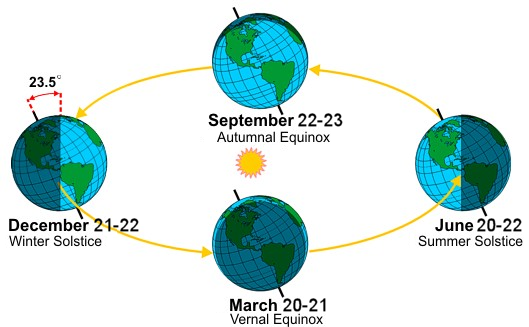
The summer solstice occurs at 10:41pm Friday, marking the official start of astronomical summer in the Northern Hemisphere. Summer weather will arrive along the East Coast just before that.
Astronomical summer begins Friday night. Image provided by the National Weather Service.
A frontal system extending from the Great Lakes into Southern Plains will slowly make its way eastward over the next few days. Ahead of the front, warm and humid air will result in an unstable atmosphere, with showers and thunderstorms developing. This front produced severe weather on Tuesday from the Front Range of the Rockies into the Central and Southern Plains, and severe thunderstorms will likely be more widespread on Wednesday from the Southern Plains into the Great Lakes. Some of the stronger storms may produce damaging winds, large hail, torrential downpours, and tornadoes, especially across parts of the Ohio Valley.
Severe weather is expected across a large swath of real estate from the Southern Plains to the Great Lakes on Wednesday. Image provided by the Storm Prediction Center.
The front will continue marching eastward, heading toward the East Coast on Thursday. Ahead of the front, hot and humid weather is expected, especially along the heavily-populated I-95 corridor. For parts of the Northeast, especially from the New York City area into Southern New England, this could be the first time the mercury reaches 90 since August 28, 2024. For areas farther south, from Philadelphia into North Carolina, temperatures already reached or exceeded 90 at least once this year but could get into the middle 90s on Thursday. Accompanying the heat will be humid conditions, with dewpoints getting into the 70s for much of the region. This will result in heat indices in the middle to upper 90s for many areas, possibly over 100 from Washington southward to North Carolina.
The heat index will get well into 90s and lower 100s for much of the East Coast Thursday afternoon. Image provided by WeatherBell.
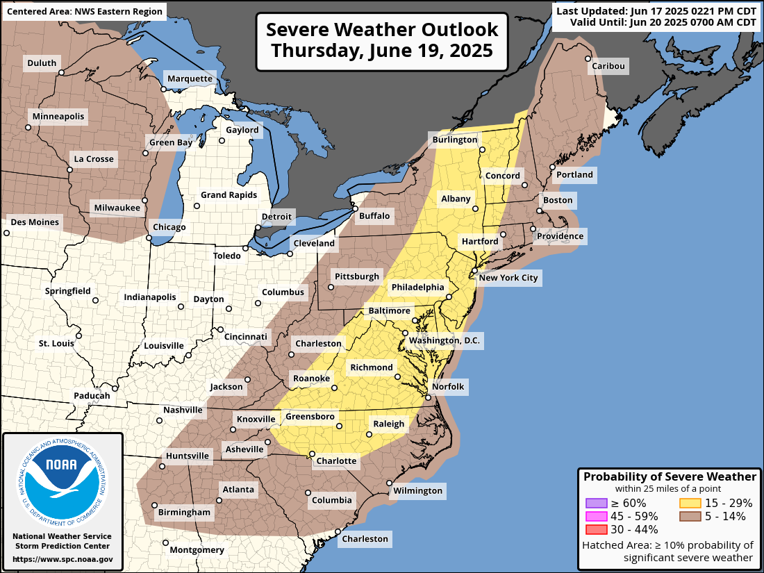
Luckily, the heat and humidity will be short-lived. The aforementioned cold front will move into the region during the afternoon and evening, producing more showers and thunderstorms, some of which could be strong to severe. The timing of the front will help determine where the strongest storms develop, but the main threats with any storms that do form are damaging winds, heavy downpours, and hail, with a few tornadoes possible.
Severe weather is possible on Thursday from parts of New England to the Carolinas. Image provided by the Storm Prediction Center
Drier weather settles into the East behind the front for Friday and Saturday, though temperatures will remain near to above normal. There’s a good chance that much of the Northeast will see its streak of 13 consecutive Saturdays with rainfall finally come to an end, but that is not guaranteed yet. Some models are showing the potential for a cluster of thunderstorms to develop in the Northern Plains Friday night, then race across the Northern Great Lakes and into parts of Northern New York and New England by Saturday night. Beyond that forecast models are showing the potential for a ridge of high pressure to settle into the East Coast for the first half of next week, resulting in an extended period of hot and humid weather.
A ridge of high pressure could bring another shot of heat and humidity to the East Coast early next week. Image provided by Pivotal Weather.
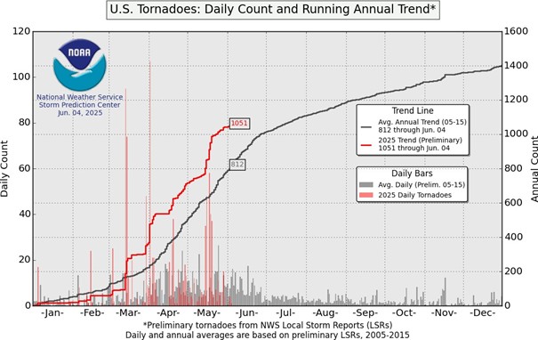
The United States is notorious for its crazy weather, especially during the spring. There are dozens of tornado outbreaks yearly, especially through the Midwestern region, otherwise known as Tornado Alley. As of June 4th, more than 1,000 tornadoes have been reported to the Storm Prediction Center. One significant outbreak of this year occurred between May 15th and 16th.
So far in 2025, 1051 tornadoes have been reported, more than 200 over the average. Image provided by the Storm Prediction Center.
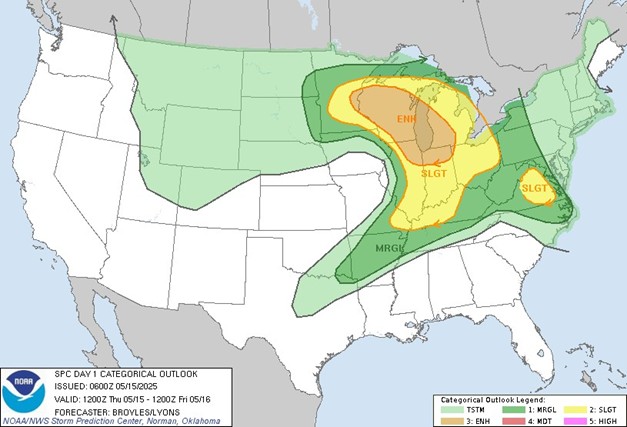
On May 15th, a low-pressure system was developing in the Central Plains, with two fronts extending from this system: a warm front moving from the Ohio Valley to the Great Lakes and a cold front moving into the Mississippi Valley from the Central Plains. The moderate instability between these fronts led the Storm Prediction Center to issue an outlook with an enhanced risk for severe weather for eastern Minnesota, central Wisconsin, Lake Michigan, northern Indiana, and northeastern Illinois.
On May 15, a large portion of the Upper Great Lakes was at an enhanced risk of severe weather. Image provided by the Storm Prediction Center.
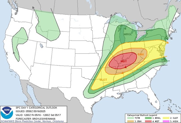
The severe weather threat continued the following day as the system moved from the Northern Plains into the Upper Mississippi Valley with the area of instability over the Ohio and Tennessee Valleys. The Storm Prediction Center issued an outlook with an enhanced risk of severe weather for most of the Ohio and Tennessee Valleys and eastern areas of the Lower Mississippi Valley, along with a moderate risk for much of Kentucky, northwestern Tennessee, southeastern Missouri, southern Illinois and Indiana.
A Severe Weather Outbreak was expected across parts of the Ohio and Tennessee Valleys on May 16. Image provided by the Storm Prediction Center.
By the end of this outbreak, 56 confirmed tornadoes had occurred, including three EF-3 and two EF-4 tornadoes. Unfortunately, 27 confirmed fatalities and more than 60 reported injuries were reported. The longest and deadliest tornado occurred near the end of the outbreak in Eastern Kentucky.
At 10:27 pm EDT on May 16th, the tornado touched down northeast of Jamestown, Kentucky, located in Russell County, and near Kentucky State Route 619. According to the NWS, the tornado may have briefly lifted for a few hundred yards due to the sporadic damage near the initial touchdown point. The tornado continued east as it intensified, crossing through several communities and leaving high-end EF-1 to EF-2 damage in its wake before crossing into Pulaski County. Here, it caused significant damage, especially in the towns of Fabush and Nancy, before continuing east into Somerset. In this community, the tornado gained enough strength to be rated an EF-3. With this strength, it continued toward the Daniel Boone National Forest, and satellite imagery across this region showed that the tornado was almost a mile wide. As the tornado exited the National Forest, it moved into the south side of London, where it continued strengthening. This densely populated area was where the heaviest damage and most casualties occurred. The tornado crossed through the Sunshine Hills subdivision, causing several homes to be removed from their foundations. Surveyors in this area had agreed that at this time, the tornado had once again gained enough strength to increase its rating to an EF-4, with up to 170 miles per hour wind speeds. The tornado continued toward the London-Corbin Airport, losing strength and being downgraded to an EF-3. Beyond the airport, where several aircraft and hangars were damaged and destroyed, it lost significant strength while still leaving a path of destruction at the Crooked Creek Golf Course, Laurel County Fairgrounds, and neighboring subdivisions. The tornado finally lifted off the ground just before midnight EDT, leaving a nearly 60-mile path of destruction, with 19 fatalities.