While the United States was celebrating its 250th birthday on the 4th, the Northern Mariana Islands were ravaged by Super Typhoon Bavi, which crossed the tiny island of Rota with the strength of a Category 5 hurricane on July 5th.
While storms of this strength might be devastating for the United States and parts of the Caribbean, areas in the Western Pacific, including the Northern Mariana Islands, and countries such as Japan, Taiwan, and China have had the time to build up infrastructure and procedures to mitigate the impacts of these storms.
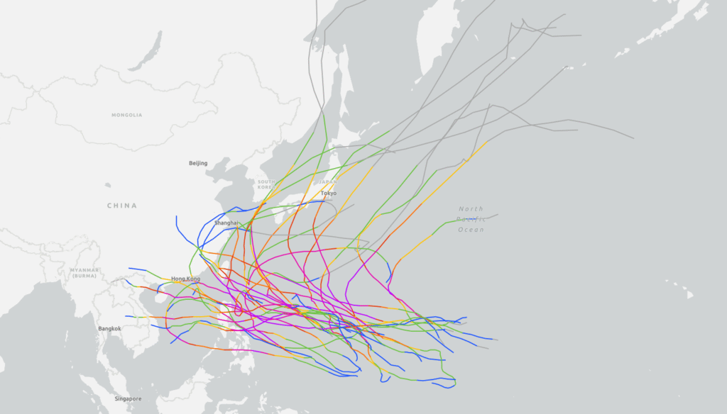
Map of the 30 most recent (satellite estimated at any point) Category 5 equivalent Super Typhoons in the Western Pacific. Many storms in the Pacific may approach land, but most remain at sea. Image provided by NOAA.
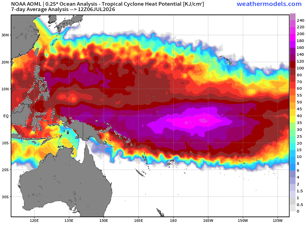
By far the biggest difference in the Western Pacific tropical season and the Atlantic tropical season is the length of the season. While the Atlantic season officially runs from June 1st to November 30th, the Western Pacific “season” runs all year, however the frequency of storms in the summer is larger compared to the winter. With a stronger El Nino, such as this year, the region for storm formation extends much further east than it does normally. Any storms that form in this extended region are likely to become Category 4 or 5 equivalent if other conditions are favorable, as they will have even more time over very warm water.
Tropical Cyclone heat potential is currently shifted east into the Central Pacific due to El Nino, allowing storms to form further into the Pacific than they normally would. Image provided by Weathermodels.com
This is also not the first Super Typhoon to have affected the Northern Marianna Islands this year. Super Typhoon Sinlaku impacted the Mariana Islands in April 2026, passing directly over Saipan, and while it did bring significant damage to the region, the most significant effect of Sinlaku was the damage to the power grid, and to buildings such as sheds or other outbuildings, as well as minor damage to the roofs of some commercial buildings. Despite the collapse of the power grid in the Northern Mariana Islands, power was restored to a majority of the island in just 3 days.
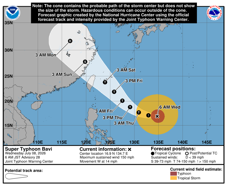
The island of Rota was directly hit by the eye of Bavi, causing widespread damage to the island. The National Weather Service expects all trees and powerlines to be snapped, causing the island to be potentially uninhabitable for weeks as recovery efforts get underway. The airport on the island was approved for emergency use, improving recovery efforts through the island. Super Typhoon Bavi remains as Category 4 equivalent storm into the Philippine sea, and is expected to impact Taiwan by early Saturday and eastern China early on Sunday local time.
Super Typhoon Bavi will be an increasing threat to Taiwan and eastern China later this week. Image provided by the National Weather Service office in Tiyan, Guam.
Atlantic hurricane season officially starts on Monday June 1 and runs through November 30, and most forecasts are showing the potential for a less active season, thanks to a developing El Nino in the Pacific.
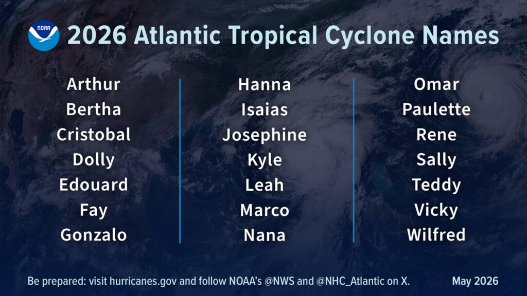
List of names for storms that form during the 2026 Hurricane Season. Image provided by NOAA.
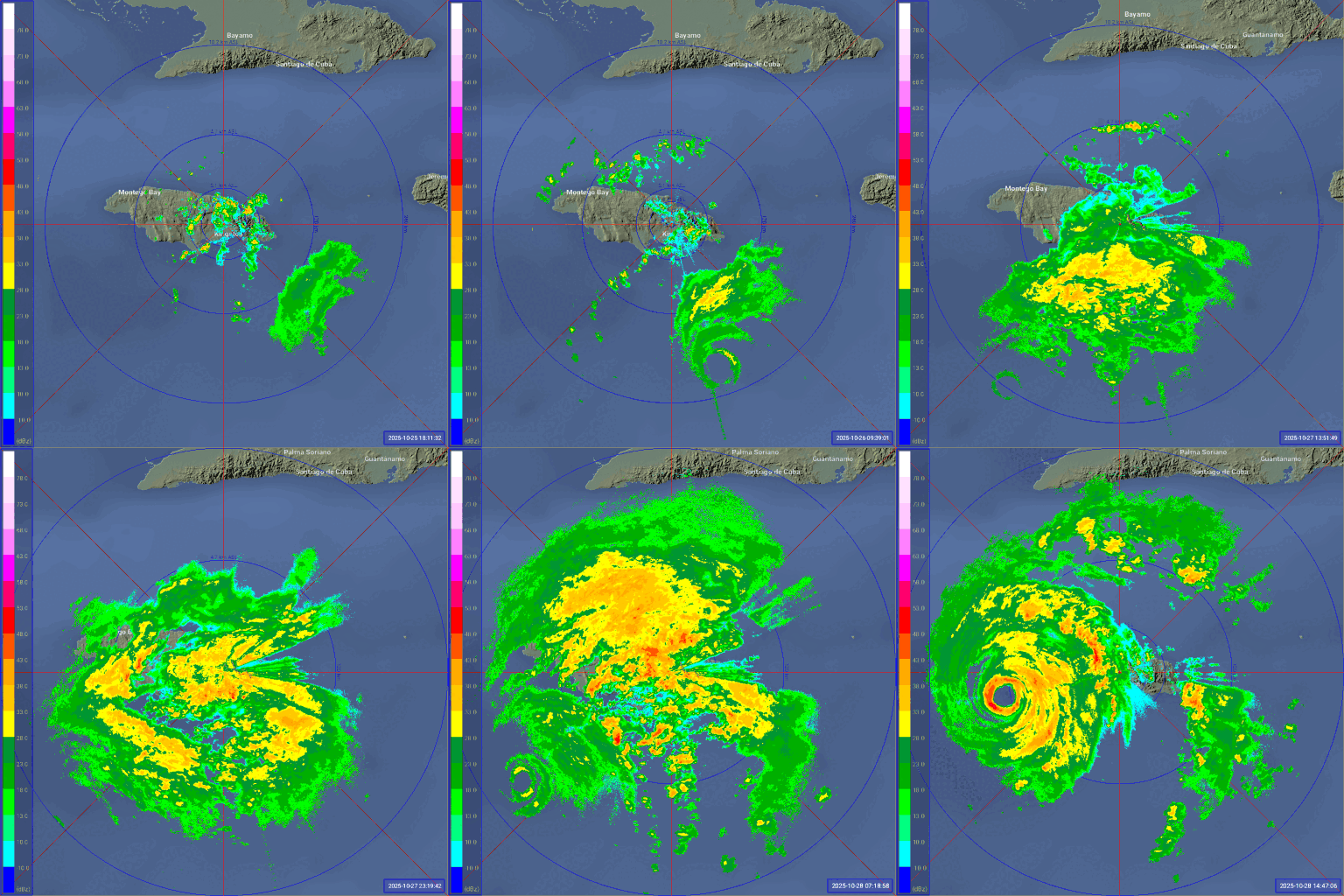
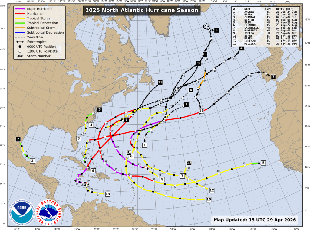
The 2025 season was a near normal season by the numbers, with 13 named storms, 5 hurricanes, and 4 major hurricanes. The season got off to a slower start than recent years, with only 3 storms through the end of July, and 6 through late August. The normal peak of hurricane season is late August and the first 3 weeks of September, but 2025 featured a complete absence of activity during that period. After Tropical Storm Fernand dissipate on August 27, there were no storms at all until Tropical Storm Gabrielle formed on September 17. That was the first of 7 named storms over the next 6 weeks, but once Hurricane Melissa dissipated on Halloween, there were no additional storms for the rest of the season. Hurricane Melissa was not only the strongest storm of the season, it was one of the strongest ever recorded in the basin. While stalling out south of Jamaica it rapidly strengthened into a Category 5 storm with maximum sustained winds near 190 mph, and a central pressure of 892mb not long before slamming into western Jamaica. The sustained winds of 190 are tied with 2019’s Hurricane Dorian, and the 1935 Labor Day Hurricane for the strongest on record in the Atlantic basin. The lowest central pressure of 892mb is tied with the 1935 Labor Day storm for the 3rd lowest on record in the Atlantic, trailing only the 882mb reading in 2005’s Hurricane Wilma, and the 888mb reading in 1988’s Hurricane Gilbert. It also is tied with the 1935 Labor Day storm for the lowest pressure on record at landfall. After the season was over, the name Melissa was retired and removed from the 6-year list of storm names. It will be replaced by Molly in 2031. Melissa is the 100th storm name to be retired in the Atlantic.
Radar loop showing Hurricane Melissa approaching Jamaica. Loop provided by Brian McNoldy, Univ. of Miami, Rosenstiel School.
Only one storm made landfall in the US in 2025 – Tropical Storm Chantal, which had maximum sustained winds of 50 mph when its center moved ashore near Myrtle Beach, South Carolina early on July 6. The one landfall is a welcome change from recent years that featured multiple storms making landfall in the US, many of them as hurricanes. In 2021, a total of 8 tropical systems made landfall in the United States, but only 2 at hurricane strength.
2025 was a less active hurricane season than previous years. Image provided by the National Hurricane Center.
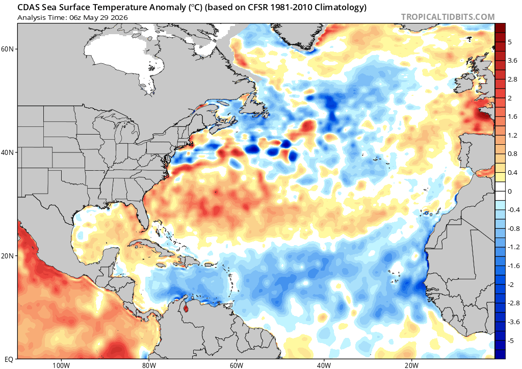
Forecasts for the upcoming season are calling for a season that features below normal activity, due to a developing El Nino in the Pacific Ocean. In fact, there are many forecasts out there calling for a very strong El Nino. In general, where there is an El Nino present, activity in the Atlantic is suppressed, due mainly to increasing wind shear. However, this is not always the case, as El Nino is just one factor. In 2023, we had a strong El Nino in place for much of the hurricane season, and there were 20 named storms that season, making it the fourth most-active season on record. Of those 20 storms, 7 became hurricanes, and 3 were major hurricanes. Hurricane Idalia slammed into the Florida Big Bend region as a Category 3 storm. Sea surface temperatures in the Atlantic are below normal for a large portion of the basin right now, especially in the Main Development Region, but they are forecast to warm to near to above normal levels, which tends to result in more storms.
Sea surface temperatures are below normal right now across much of the Tropical Atlantic and much of the Caribbean. Image provided by Tropical Tidbits.
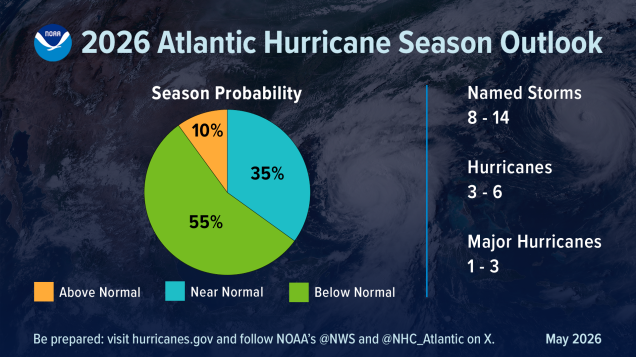
NOAA issued their seasonal hurricane outlook on May 21, and it calls for a 55 percent chance for a below normal season, a 35 percent chance for a near normal season, and just a 10 percent chance for an above normal season. Most of the other hurricane outlooks issued by various outlets are also expecting a near to below normal season, due to the signals mentioned above. An average season consists of 14.4 named storms, of which 7.2 become hurricanes and 3.2 become major hurricanes (Category 3 or higher on the Saffir-Simpson scale). NOAA’s forecast for this season calls for 8-14 named storms, 3-6 hurricanes, and 1-3 major hurricanes. The Tropical Meteorology Project at Colorado State, the first group to forecast how active a hurricane season would be, originally led by the late Dr. Bill Gray, will issue their updated forecast on June 10. Their initial forecast from April called for a below average season, with 13 named storms, 6 hurricanes, and 2 major hurricanes.
Tropical activity in the Atlantic is expected to be below normal this season. Image provided by NOAA.
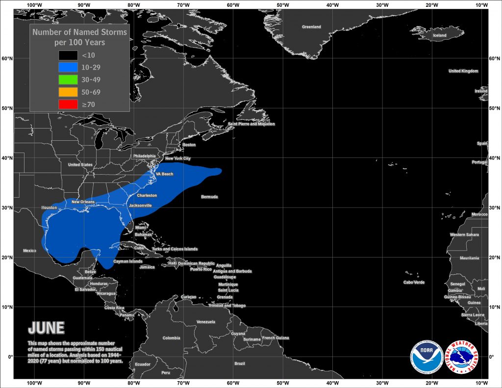
Despite the early start for the many of the past several years, the average date for the first named storm in the Atlantic is still June 20, and the average date for the first hurricane is August 11. Over 97% of all named storms in the Atlantic form between June 1 and November 30. Most early season storms tend to be on the weaker side, as water temperatures are cooler, and wind shear is usually a little stronger. A hurricane hasn’t made landfall in the United States before July 1 since Hurricane Bonnie came ashore as a minimal hurricane near the Texas/Louisiana border on June 26, 1986.
Based on climatology, the most likely spots for an early season storm are off the Southeast coast, in the Gulf of Mexico, or the northwestern Caribbean. Image provided by the National Hurricane Center.
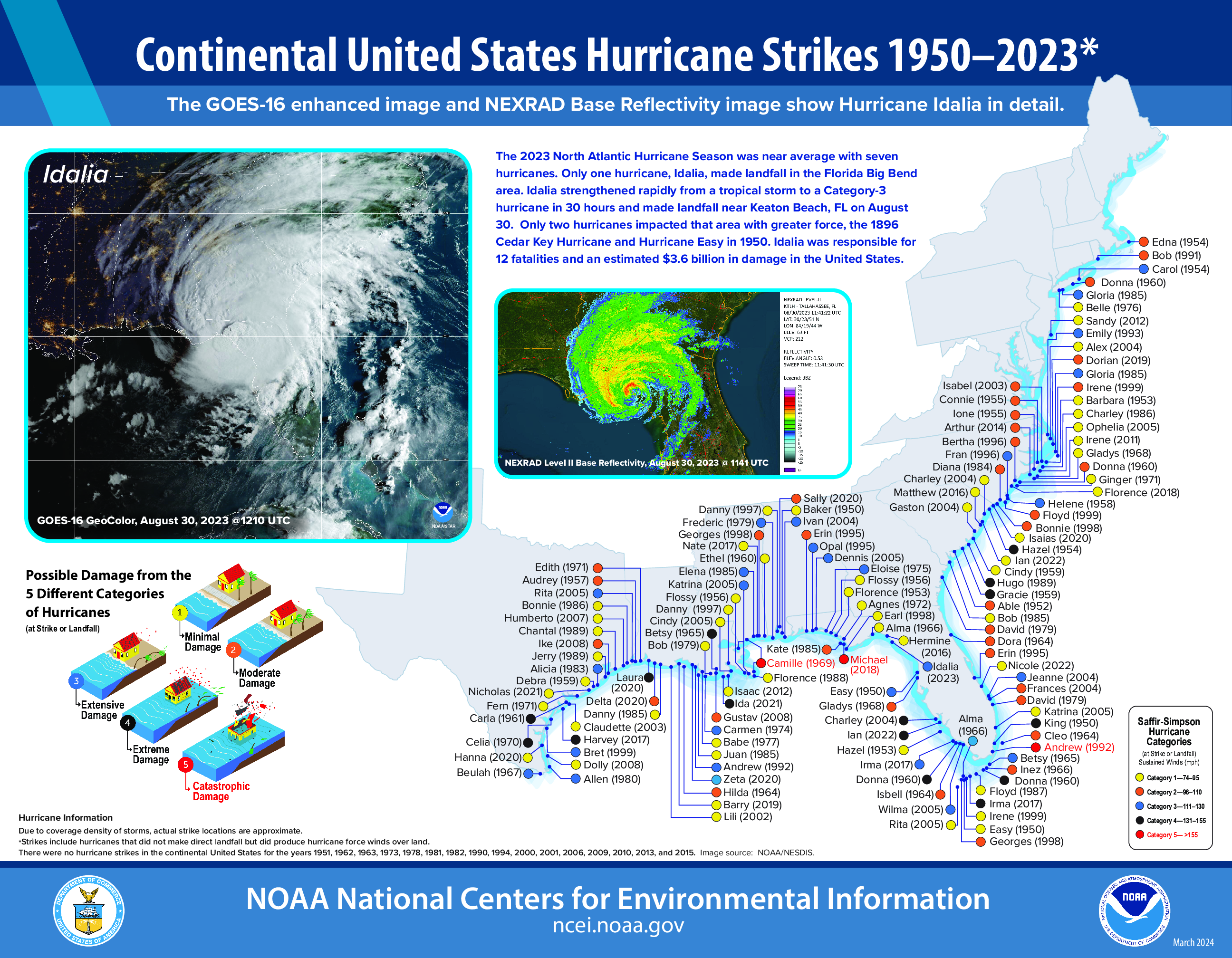
The number of storms that form in any given season has no correlation on how many storms (if any) will impact the United States. In 2010, 19 named storms were observed in the Atlantic, 12 of them became hurricanes, and 5 were major hurricanes. Only one storm made landfall in the United States, and that was Bonnie, which was a minimal tropical storm at landfall. In 1990, there were a total 14 named storms, 8 of them hurricanes and 1 major hurricane. Not a single one of them made landfall in the United States. On the flip side, only 7 named storms formed in 1992, and the first one didn’t develop until August 16. That storm, however, was named Andrew, and it made landfall just south of Miami as a category 5 storm. It only takes one storm to ruin your entire year.
Virtually the entire Atlantic and Gust Coast are susceptible to a direct strike from a hurricane. Image provided by the National Centers for Environmental Information
As always, you should get your weather information from a trusted source, especially when dealing with tropical systems. It’s always best to prepare ahead of the season. Chances are, you won’t have anything to worry about, but in case you do, it’s always good to be prepared.
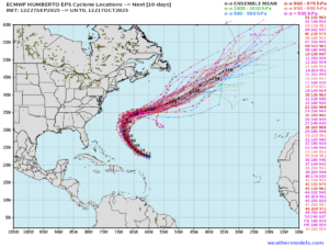
While the 2025 Atlantic Hurricane season has remained relatively quiet, things are starting to ramp up as we end September. Hurricane Humberto, now a Category 5 storm, will continue on a northwest track before turning northeast toward the beginning of the week. The storm will travel between Bermuda and the eastern United States coast, while remaining over open waters as it progresses into the Northeast Atlantic.
Humberto will remain over open waters as it moves northwest before turning northeast near the beginning of the week. Image provided by Weather Models.
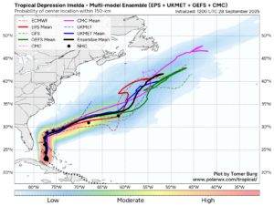
Another disturbance being monitored near Haiti and the Bahamas has been named Tropical Storm Imelda, with strengthening expected to continue through the start of the week as it becomes more organized. This system will progress north, toward the Carolinas, where areas are still recovering from the devastation brought by Helene just one year ago.
Tropical Storm Imelda will progress north-northwest, where it will interact with a stalled front. These two systems will contribute to heavy rainfall across the Carolinas. Image provided by Tomer Berg.
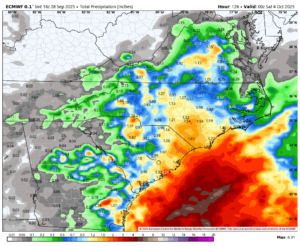
A frontal system moving off the East Coast will remain stalled, allowing rainfall to continue through the next several days. As Tropical Storm Imelda moves north, it will interact with the stalled front, then turn east and remain out at sea. Areas closer to the North and South Carolina coasts will have the highest chance of significant rainfall from these systems, with higher totals also possible locally, especially in higher terrain.
Areas of North and South Carolina could see several inches of rain as a result of a stalled front and a tropical system in the Atlantic. Image provided by Weatherbell.
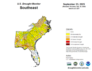
Much of this area is currently experiencing abnormally dry to moderate drought conditions, so many residents in this area are hoping for relief, but that will likely not be the case. When heavy and excessive rainfall occurs, especially in regions experiencing drought, the ground struggles to absorb the water at the rate at which it is falling. This, in turn, will cause flooding, which can be extreme and catastrophic, especially in areas still recovering from previous flooding events.
Most areas of North and South Carolina need rain, but excessive rainfall in a single event can lead to catastrophic flooding. Image provided by the National Drought Mitigation Center.
The 2025 Hurricane Season has been fairly quiet across both the Atlantic and Pacific, especially over the past month, but that has quickly changed in the past week.
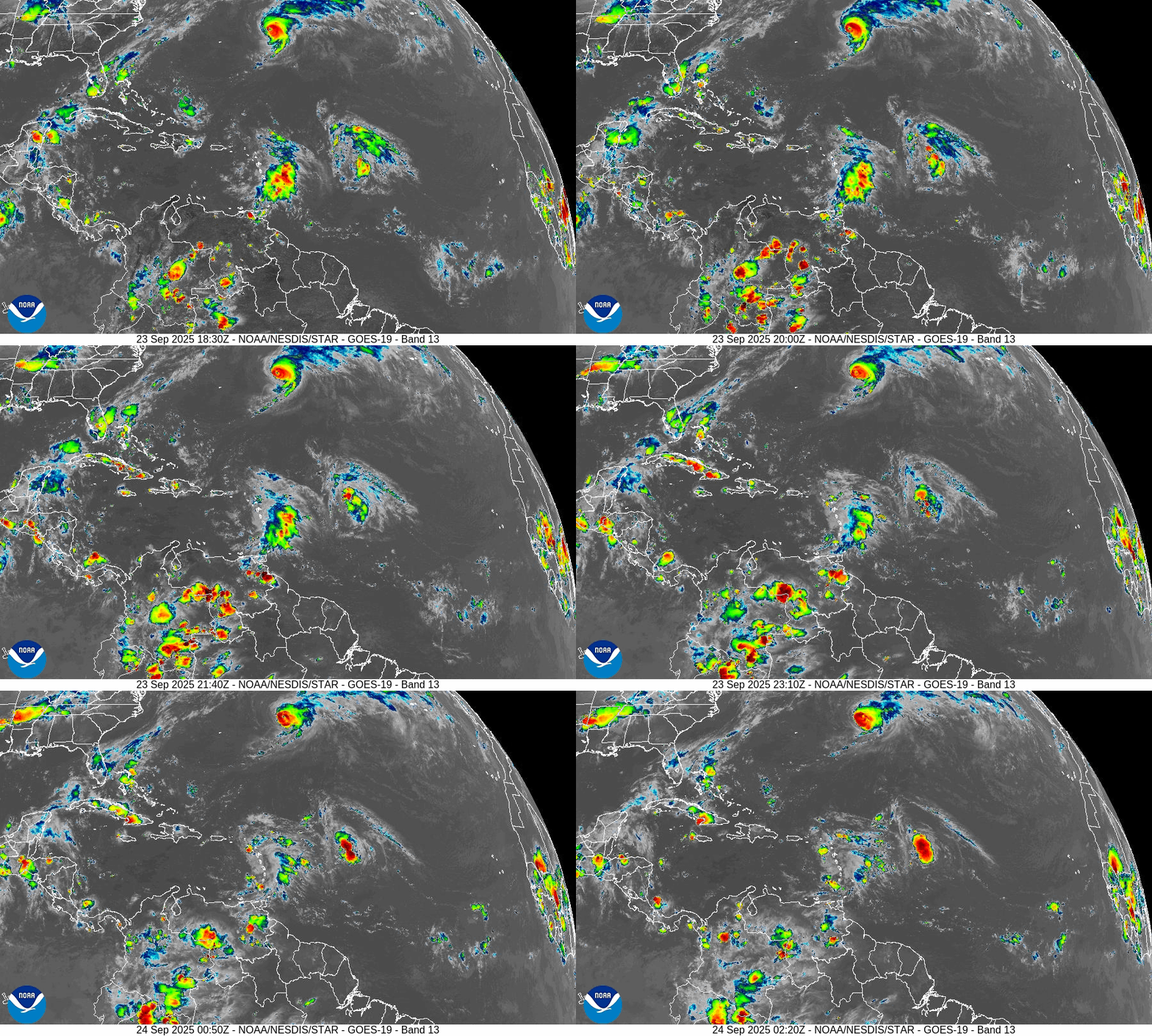
The Atlantic is quickly getting active with Hurricane Gabrielle and two other developing systems. Loop provided by NOAA.
Hurricane Gabrielle remains a powerful Category 3 hurricane this evening in the central Atlantic. As of 11pm EDT Gabrielle was centered about 1520 miles west of the Azores, moving toward the east-northeast at 22 mph. After peaking as a Category 4 storm while passing east of Bermuda on Monday, maximum sustained winds have decreased to near 125 mph. Gabrielle is expected to head eastward over the open waters of the Atlantic at a rapid pace over the next few days while steadily weakening as it crosses cooler water. The system is still expected to be a minimal hurricane when it crosses the Azores late Thursday into Friday. As a result, a Hurricane Watch has been issued for the island chain. After that, it should become extratropical as it approaches the coast of Portugal this weekend. Gabrielle will continue to produce rough surf across the East Coast, with a high risk for rip currents across much of the region.
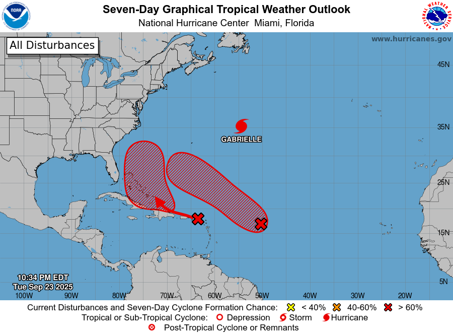
Gabrielle isn’t the only system we’re keeping an eye on in the Atlantic. There are two tropical waves, one about 750 miles east of the Leeward Islands, and the other crossing the northeastern Caribbean, that are both slowly organizing.
There are two areas that may develop in the Atlantic plus Hurricane Gabrielle remains a potent system. Image provided by the National Hurricane Center.
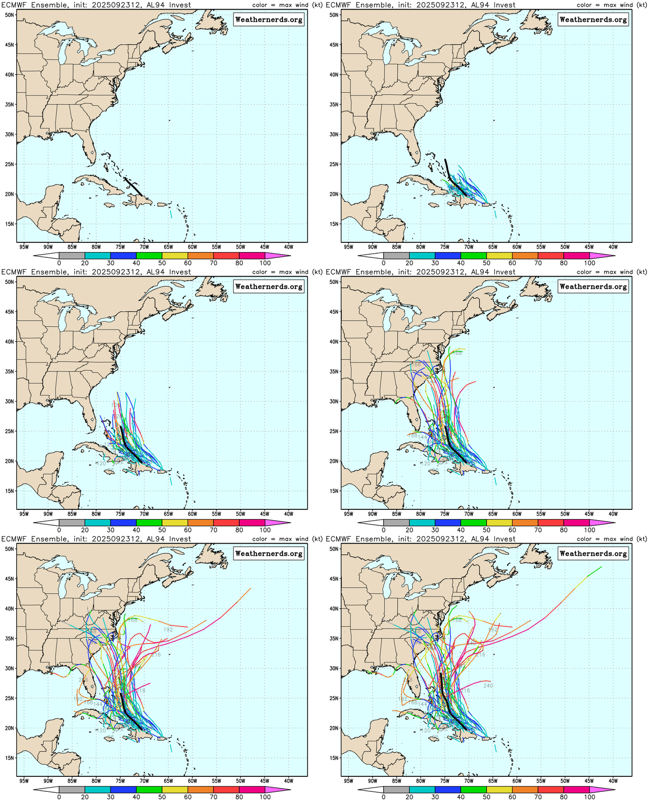
The westernmost wave will bring squally conditions to the northeastern Caribbean, including Puerto Rico and the Virgin Islands for the next day or two. After that, it should move towards the Turks and Caicos, Dominican Republic, and the Bahamas, where conditions will be more favorable for the system to develop. How quickly it develops and where it heads are still uncertain, but interests in the Bahamas and along the East Coast should keep a close eye on this system and its development later this week.
There is plenty of uncertainty as to where the system in the Northeastern Caribbean could head. Loop provided by Weathernerds.org
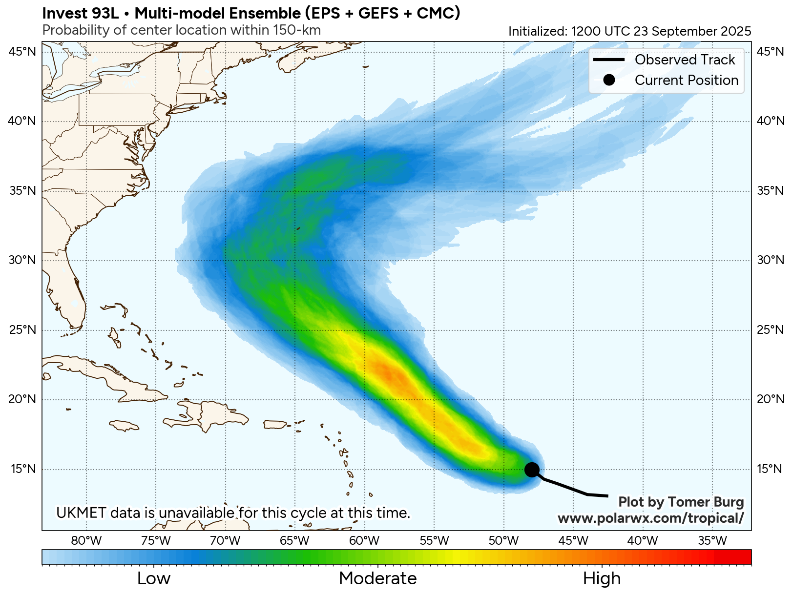
The system farther to the east is a bit more organized at this time, and has a better chance to become a tropical depression later this week. Forecast models show this system heading more toward the northwest, likely staying north of the Lesser Antilles, while steadily strengthening. This system could follow a track similar to what Gabrielle did last weekend, and could become a threat to Bermuda towards the end of the week.
The system well east of the Lesser Antilles could become a threat to Bermuda toward the weekend. Image provided by PolarWx.
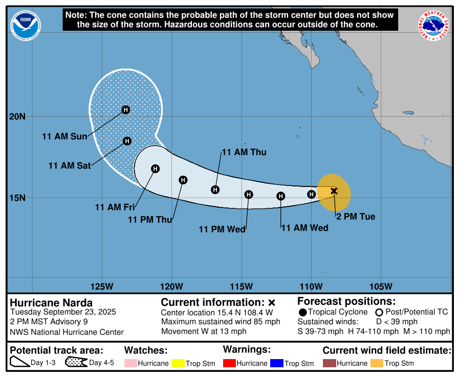
In the Eastern Pacific, Hurricane Narda continues to strengthen as it heads away from the coast of Mexico. As of 5pm EDT, Narda had maximum sustained winds near 85 mph while centered about 365 miles southwest of Manzanillo, Mexico, moving toward the west at 13 mph. The forecast for Narda is fairly straightforward for the next few days. It should continue westward over open water in the Eastern Pacific while strengthening, likely reaching Category 2 strength, possibly a a weak Category 3. Towards the end of the week it will turn more toward the northwest and then north, steadily weakening as it moves over cooler water.
Forecast track for Hurricane Narda. Image provided by the National Hurricane Center.
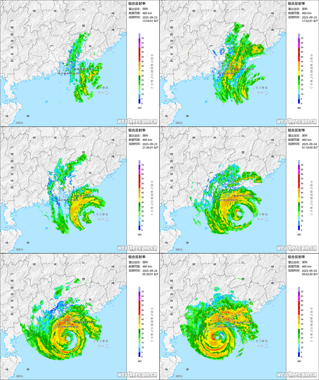
Over in the Western Pacific, Typhoon Ragasa is passing about 200 miles south of Hong Kong, on its way to landfall in southern China on Wednesday. It still has top winds near 125 mph, but it expected to weaken a bit more before landfall. Over the weekend at peaked as a Super Typhoon with sustained winds near 170 mph as it passes just north of Luzon in the Philippines.
Radar loop showing Typhoon Ragasa just off the southern coast of China. Loop provided by Brian McNoldy, Univ. of Miami, Rosenstiel School.
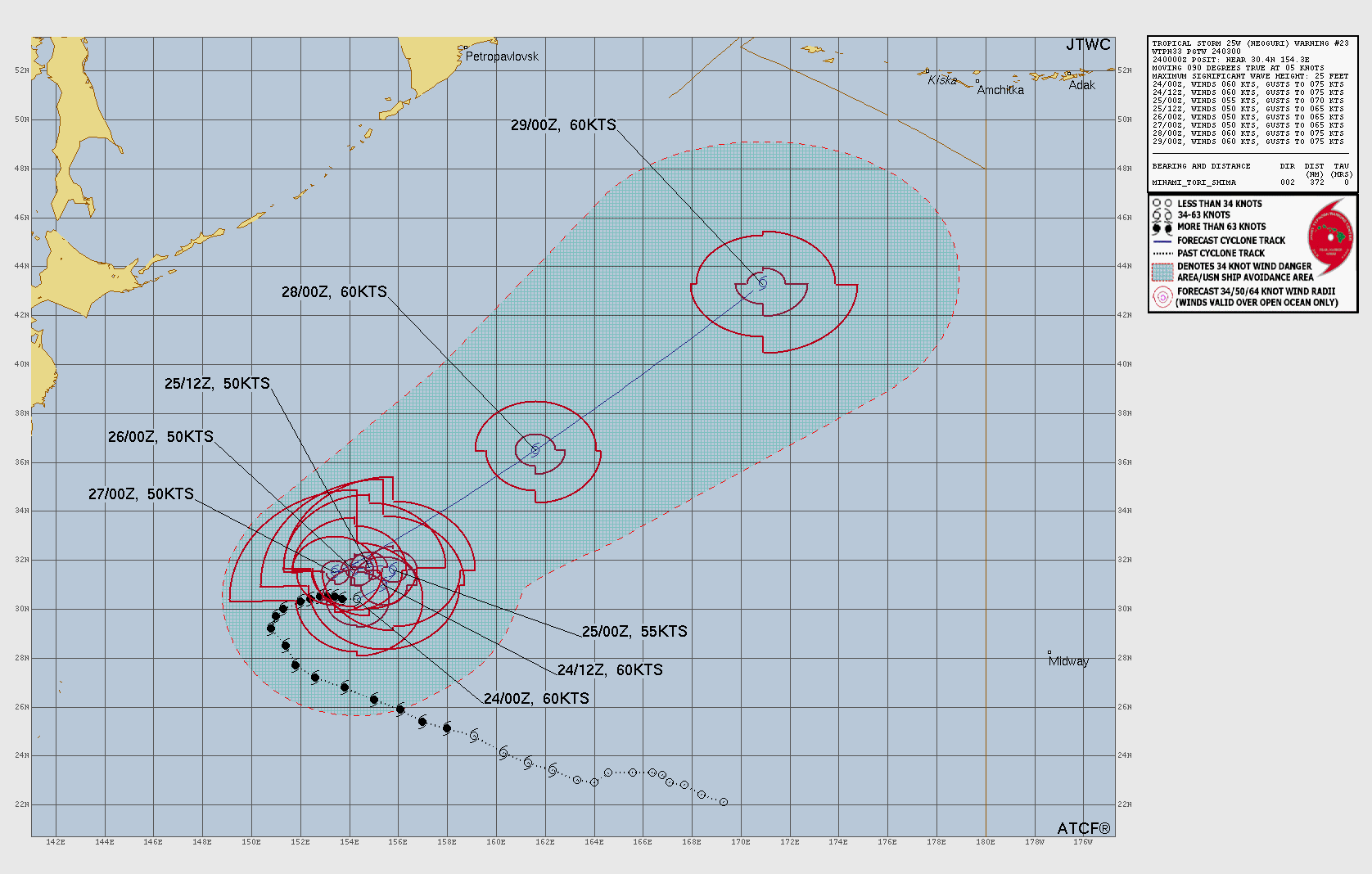
Typhoon Neoguri is centered about 1000 miles east-southeast of Japan this evening. Maximum sustained winds had decreased to near 75 mph. Neoguri is expected to mill around for the next couple of days while slowly weakening, not threatening any land areas. By the end of the week it should start to head northeastward, likely becoming a potent extratropical system as it heads toward the Gulf of Alaska.
Forecast track for Typhoon Neoguri. Image provided by the Joint Typhoon Warning Center.
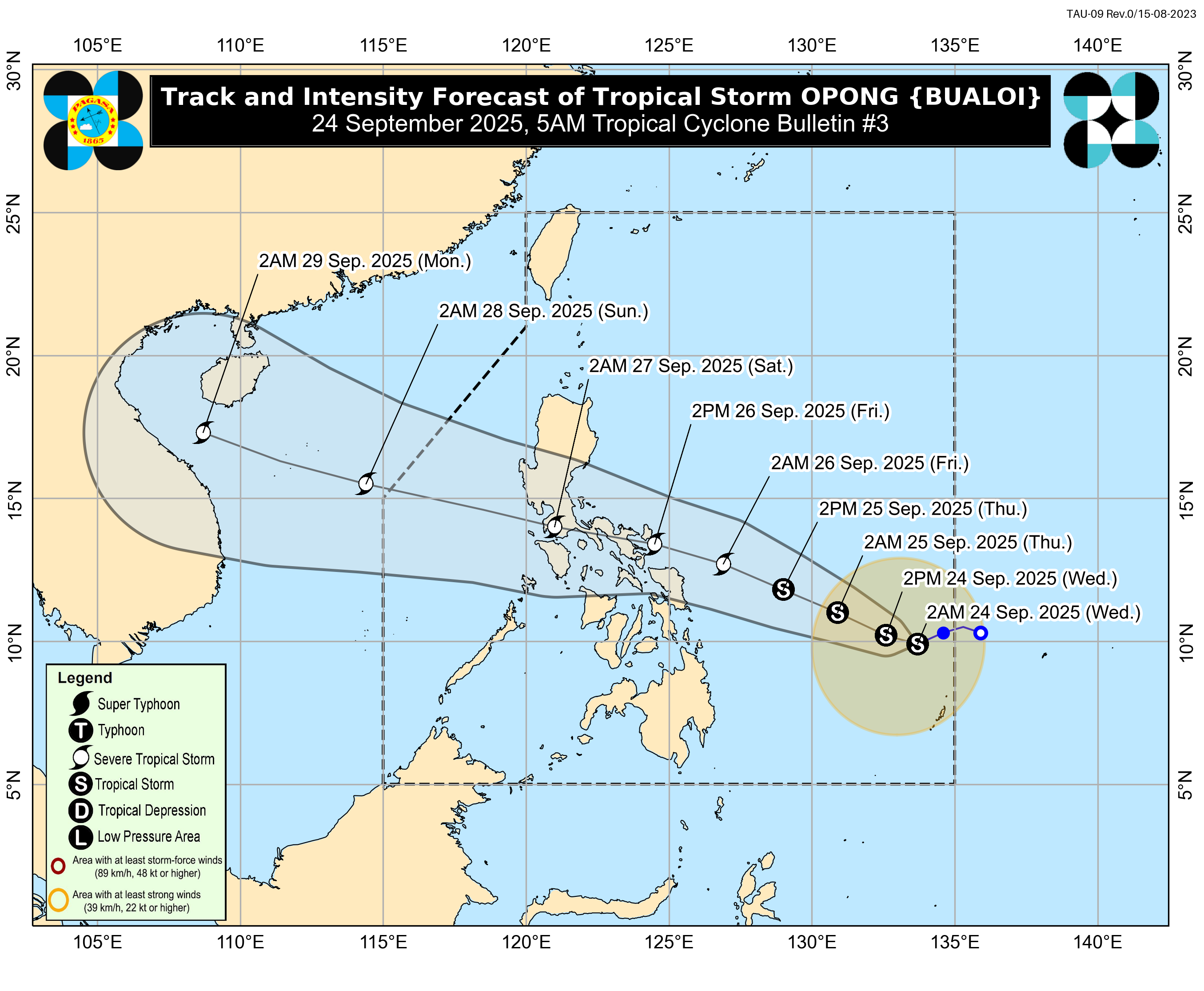
Tropical Storm Bualoi has developed well east of the Philippines this evening. The system currently has maximum sustained winds near 40 mph, and should steadily strengthen over the next few days while heading off toward the west-northwest. Current forecasts are for the system to be near typhoon strength as it crosses the central Philippines at the end of the week and start of the weekend. After that, it should move into the South China Sea and could become a threat to Vietnam by early next week.
Forecast track for Tropical Storm Bualoi. Image provided by the Philippine Atmospheric, Geophysical and Astronomical Services Administration.
Although the peak of hurricane season is in mid-September, the rest of September and much of October is usually active across most of the Northern Hemisphere, so this active period could continue beyond the next week or so.
September is normally the peak of hurricane season, but that hasn’t been that case this year, things have been quiet for a while now, though that could be changing.
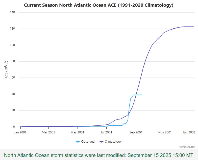
Tropical Cyclone Activity in the Atlantic is now below normal for the season. Image provided by Colorado State University.
The last time there was an active system in the Atlantic was on August 29, when Tropical Storm Fernand became extratropical more than 600 miles east-southeast of Newfoundland, in the open waters of the North Atlantic. Climatologically, the peak of the season is September 10 – the day you are most likely to observe a tropical cyclone somewhere in the Atlantic, Caribbean, or the Gulf. Instead, we’re at 18 days and counting without a system. How unusual is that? The last time there were no active systems in the Atlantic between August 29 and September 15 was in 1939, right at the start of World War II. However, that quiet period may be coming to an end over the next few days.
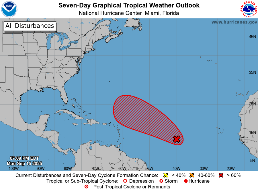
A tropical wave in the central Atlantic could become a tropical depression in the next few days. Image provided by the National Hurricane Center.
A tropical wave that is making its way across the Atlantic’s Main Development Region is slowly getting its act together. Shower and thunderstorm activity is disorganized at this time, and upper-level conditions are not that favorable right now, but as the system continues west to west-northwestward over the next few days, some additional development is likely. There is some dry air ahead of the system, but as it starts to gain latitude, it should encounter a more moist environment. Additionally, there is an upper-level low pressure area to the north of the system, but as it heads westward, it should pull away from that, encountering more favorable conditions for development. Sea Surface Temperatures are already warm enough, so that shouldn’t be an inhibiting factor.
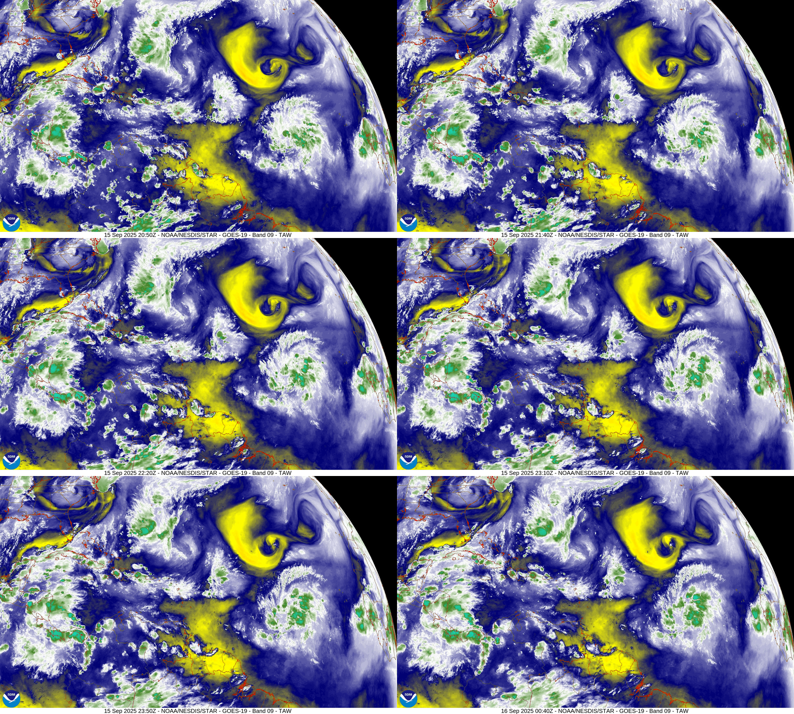
Satellite loop shows an upper-level low will dry air north of the tropical wave. Loop provided by NOAA. (Click on map for loop)
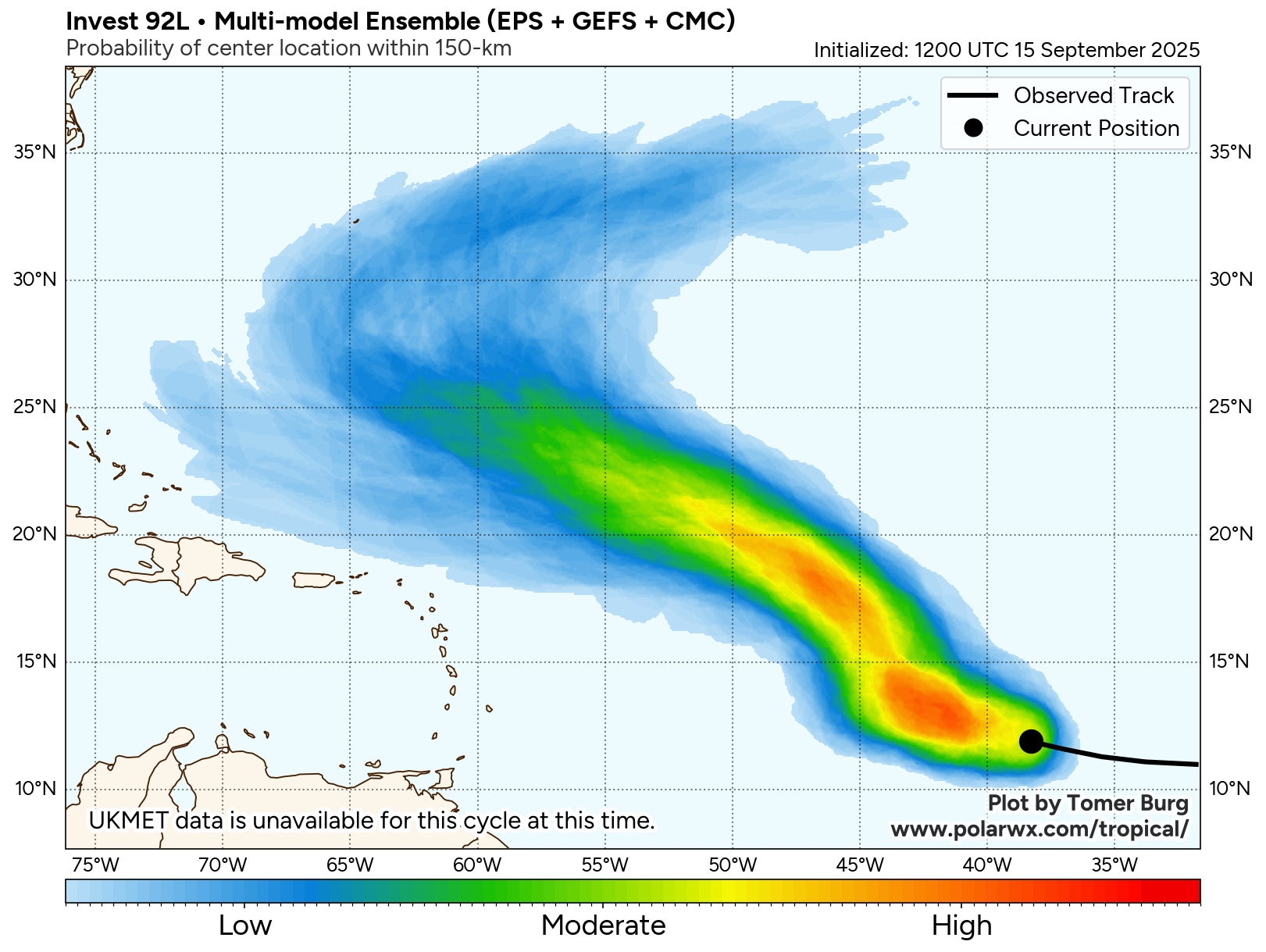
Most of the forecast models are showing the potential for the system to organize into a tropical depression during the middle to latter portion of the week as it continues to head west-northwestward. Additional strengthening is expected, and the system could become Tropical Storm Gabrielle by this coming weekend. As for where it should go, with a ridge of high pressure over the central Atlantic, it should continue west-northwestward through much of the week. By the weekend, it could reach the western edge of that ridge and turn more toward the north and the eventually northeast and out to sea. Where it makes that turn will determine whether the system will eventually be a threat to Bermuda, but otherwise, it does not look like this system will be a threat to any other land areas over the next 5-7 days.
Forecast models show the system staying north of the Caribbean over the next week. Image provided by Tomer Burg.
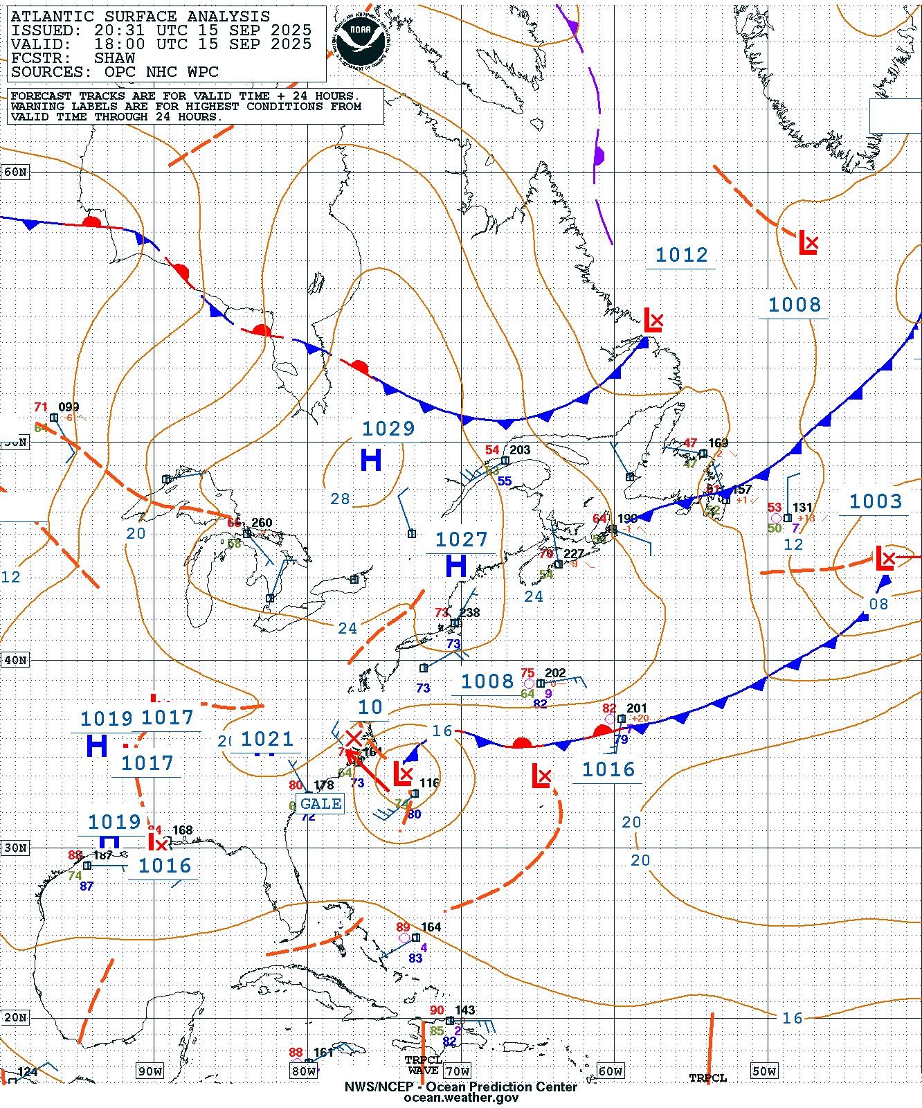
Closer to the United States, there’s another system we’re keeping an eye on, though it isn’t tropical at this time. Low pressure has developed along an old frontal boundary off the North Carolina coastline. Meanwhile, there’s an upper-level low pressure area over central North Carolina. That upper-level low will pull the surface storm towards the coast of eastern North Carolina and the Virginia Tidewater into Tuesday. This will result in some heavy rain along with embedded thunderstorms across the region over the next day or two. Locations from Richmond to Raleigh and points eastward could receive 2-4 inches of rain by Wednesday morning, with isolated totals in excess of 5 inches possible.
Surface map for the western Atlantic Ocean from Monday evening. Image provided by the Ocean Prediction Center.
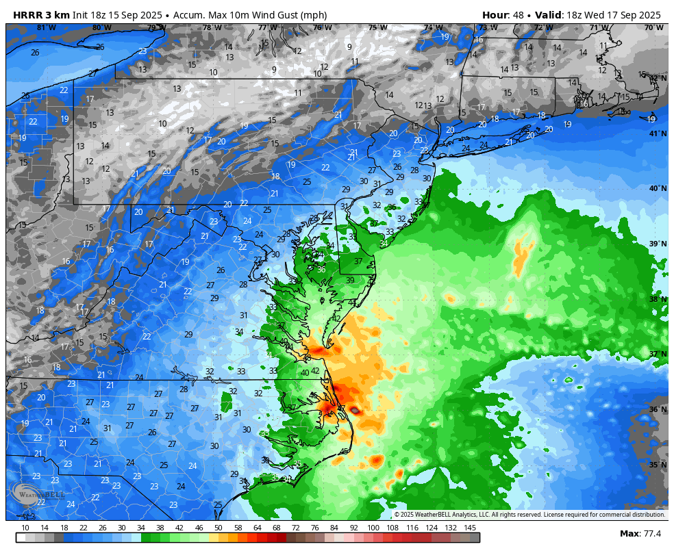
With a large area of high pressure to the north, the system won’t move that much for the next 24 hours, but should start to pull away and head out to sea by Wednesday and Thursday. The gradient between the high to the north and the low pressure area will result in some rather gusty winds, especially near the coast. Wind gusts of 35-45 mph and perhaps stronger are expected for coastal areas from Southern New Jersey to the North Carolina Outer Banks through Wednesday. In addition to the hazardous marine conditions, this will create a high risk for dangerous rip currents at beaches in this stretch. That high pressure area will also block any northward progress the storm will try to make, preventing much-needed significant rainfall from reaching portions of New England and southeastern New York, where a significant drought has been worsening over the past few months.
Strong wind gusts are expected along the Mid-Atlantic coast into Wednesday. Image provided by WeatherBell.
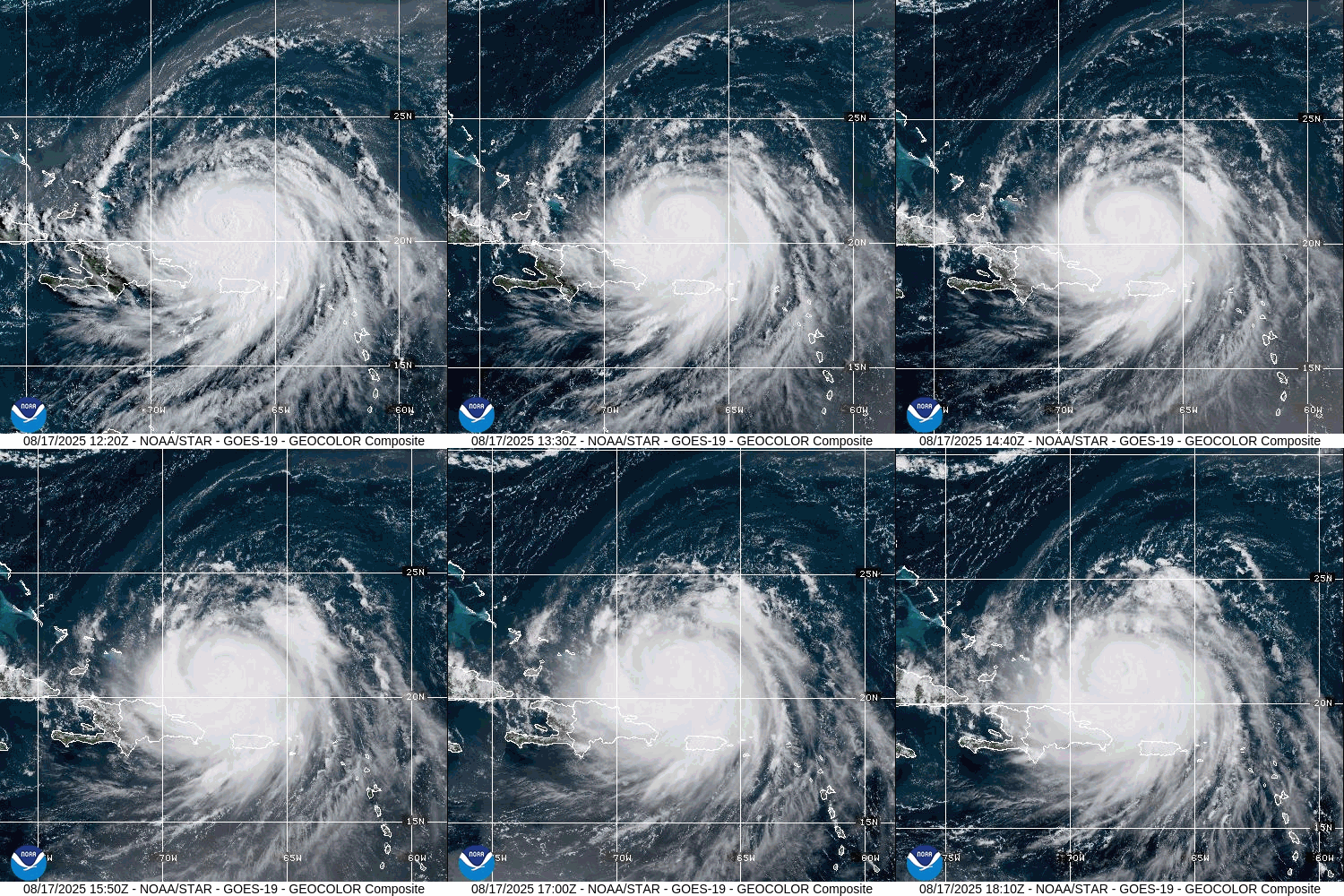
Hurricane Erin is pulling away from Puerto Rico and the Virgin Islands, but remains a powerful storm.
Hurricane Erin is passing north of the Dominican Republic this afternoon. Loop provided by NOAA.
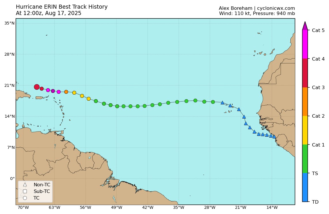
A tropical wave that moved off the west coast of Africa last weekend developed into Tropical Storm Erin as it crosses the Cabo Verde Islands on Monday. For much of last week Erin quickly crossed the tropical Atlantic, fighting off dry air from Saharan Dust and cooler sea surface temperatures while slowly gathering strength. By midday Friday, Erin finally had strengthened into the first hurricane of the 2025 season, about a week later than average date for the first hurricane of the year. Erin quickly made up for lost time though, taking advantage of favorable conditions to explosively develop into a Category 5 hurricane on Saturday, just the 43rd Category 5 storm on record in the Atlantic, dating back to 1851, the 9th one to form before September 1.
We’ve been tracking the system that became Erin since it moved off the coast of Africa. Image provided by CyclonicWx.
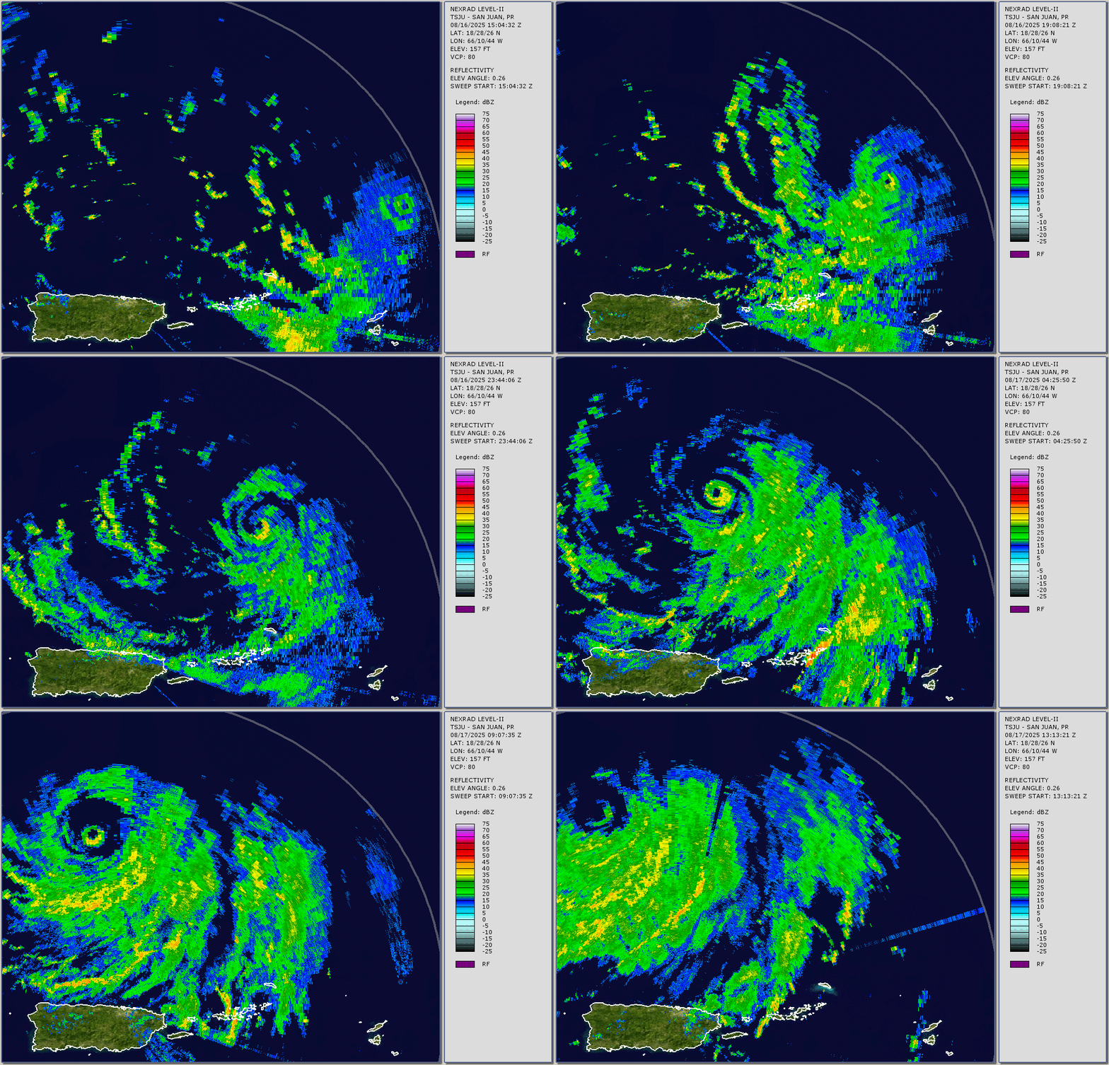
The center of Erin passed about 150 miles north of the Virgin Islands and Puerto Rico on Saturday, but the outer bands of the storm brought adverse conditions into the Virgin Islands. Observations from the British Virgin Islands indicate that over 9 inches of rain fell in about 18 hours on Saturday, along with wind gusts in excess of 60 mph. In the United States Virgin Islands and Puerto Rico, rainfall totals of up 5 inches resulted in flooding in many areas, with wind gusts to 50 mph resulting in downed trees and power lines.
Radar loop from Puerto Rico showing the passage of Hurricane Erin. Loop provided by Brian McNoldy, Univ. of Miami, Rosenstiel School
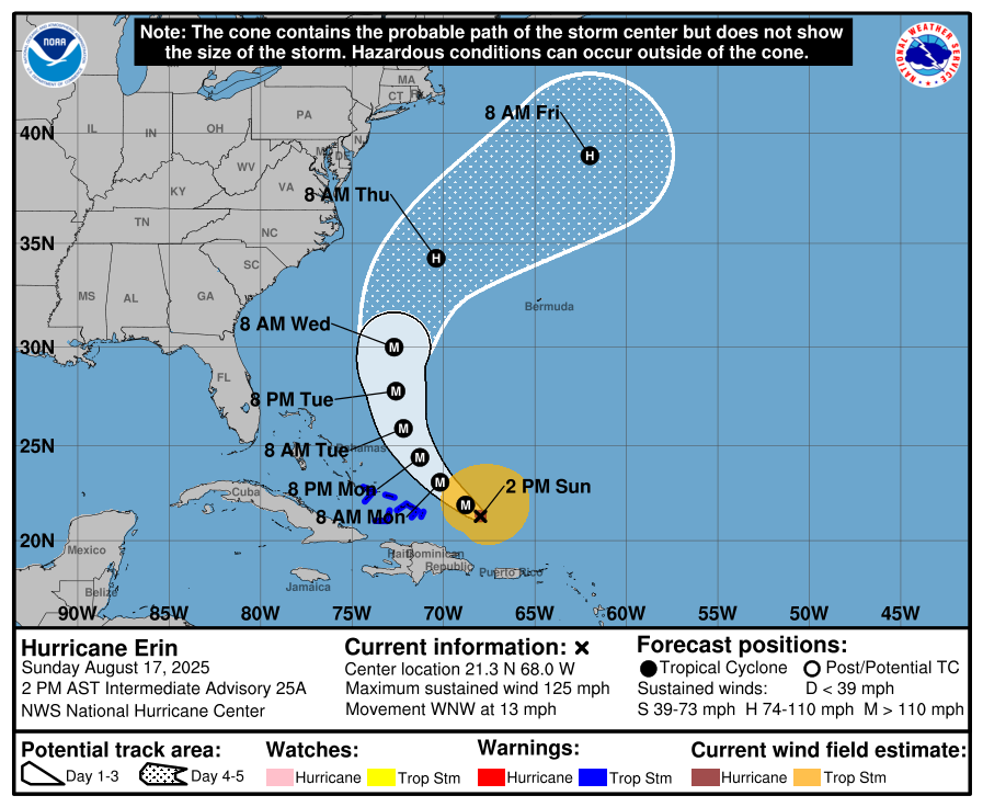
As of 2pm Sunday, Erin was still a Category 3 hurricane was maximum sustained winds near 125 mph, down from its peak of 160 mph on Saturday. Erin was centered about 200 miles east of Grand Turk Island, moving toward the west-northwest at 13 mph. Tropical Storm Warnings are in effect for the Turks and Caicos Islands as well as the southeastern Bahamas.
Forecast track for Hurricane Erin. Image provided by the National Hurricane Center.
The forecast for Erin is fairly simple at this point. Erin is expected to turn more toward the northwest and then north over the next day or two as it reaches the western edge of a ridge of high pressure. This will turn the storm away from the Bahamas and the East Coast, while also passing west of Bermuda. Erin may restrengthen a little, but it will also become a much larger storm. As a result, some of the outer bands of the storm could bring some squally weather to parts of the Bahamas and Turks and Caicos Islands today and Monday, and possibly to Bermuda and the Outer Banks of North Carolina towards mid-week. Erin should turn more toward the northeast during the latter half of the week, heading out into the open Atlantic well southeast of New England and Nova Scotia.
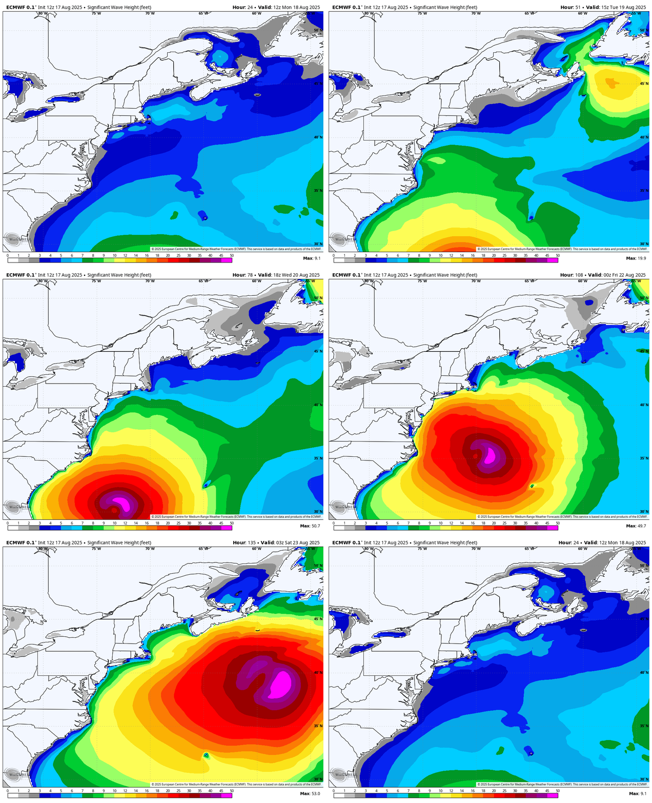
Hurricane Erin will generate large waves and rough surf for much for the East Coast this week. Loop provided by WeatherBell.
Erin will generate rough surf and large waves for much of the East Coast for a good chunk of the upcoming week, increasing the threat of riptides for much of the region. With a new moon next weekend, tides will be astronomically high later this week, so coastal flooding could be an issue near high tide across parts of the Northeast US and Atlantic Canada.
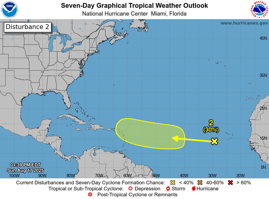
Another system in the eastern Atlantic has some potential to develop later this week. Image provided by the National Hurricane Center.
As we head towards the peak of Hurricane Season there will be more systems to watch, and we already have another one to keep an eye on. A tropical wave is producing disorganized showers and thunderstorms near the Cabo Verde Islands today. It will quickly head westward across the Atlantic this week. Conditions are not that favorable for development at this time, but could improve later this week as it gets into the central Atlantic. Some of the forecast models do show this system developing later in the week, so we’ll keep an eye on it this week.
August typically brings a range of weather conditions to the United States, from excessive heat to tropical systems and everything in between. As we move into the middle of the month, we are beginning to see this play out.
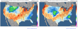
This weekend will bring dry and warm weather to much of the country. Many areas are expected to experience above-normal temperatures on Saturday. In contrast, others, including the Mid-Atlantic, Southeast, Intermountain West, and North-Central Rockies, are expected to experience below-normal temperatures. A cold front moving into the center of the country on Saturday will allow temperatures to dip below normal across the Central Plains on Sunday. Temperatures will also shift above normal on Sunday in interior areas of the Pacific Northwest as high pressure builds in across the region.
Temperatures average mainly above normal through the weekend across much of the country, with below normal temperatures in the Intermountain West, Southeast, and Mid-Atlantic. Images provided by Weathermodels.
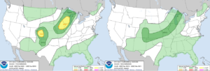
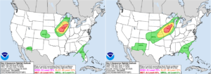
A cold front moving across the central United States will bring a marginal risk of severe weather to the Upper Great Lakes and Central Mississippi Valley, as well as the Central and Southern Plains, through the weekend. The highest risk for severe storms will be on Saturday, with a slight risk of severe weather across southwestern Wisconsin, southeastern Minnesota, northeastern Iowa, and eastern Colorado.
There is a slight risk of severe weather on Saturday for the Upper Midwest and eastern Colorado, with a marginal risk through the weekend from the Upper Midwest to the Southern Plains. Images provided by the Storm Prediction Center.
The cold front will also bring heavy rainfall to the Upper Midwest. There is a moderate risk of excessive rainfall across southwest Wisconsin, eastern Iowa, northwestern Illinois, and northeast Missouri on both Saturday and Sunday, with a slight risk extending from southern Wisconsin to eastern Kansas. A stationary front will continue to produce rain and thunderstorms across much of the Southeastern United States, with a marginal risk of excessive rainfall on both days. Meanwhile, in the Southwest, monsoonal moisture will bring showers and thunderstorms to the region with a marginal risk of excessive rainfall for both Saturday and Sunday.
The Upper Midwest will face the highest risk of excessive rainfall through the weekend, with areas such as the Southeast and Southwest also facing a marginal risk. Images provided by the Weather Prediction Center.
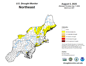
As we move into the beginning of next week, temperatures are expected to rise across the Northeast, with above-normal values anticipated for much of the week. The slow-moving front will bring showers and thunderstorms to the Midwest through the middle of the week before moving into the Northeast toward the second half of the week. The Northeast will see its next potential for rain as this front moves through, ending its dry stretch, which has caused some areas to become abnormally dry across the region.
Areas of the Northeast are becoming abnormally dry as the region continues to see dry conditions. Image provided by the National Drought Mitigation Center.
The stationary front across the south will continue to bring the potential for rain and thunderstorms to much of the region through the end of the week. Areas in the Southwest will also see the possibility of showers and thunderstorms each afternoon as monsoonal moisture remains over the region. Otherwise, high pressure will continue to bring dry weather to the majority of the country.
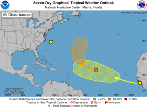
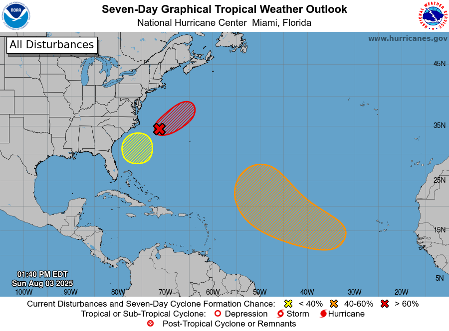
We will also be monitoring tropical development as the week progresses, since the National Hurricane Center continues to monitor areas in the Atlantic Ocean for possible development over the next seven days. Some models have been in favor of tropical development by the end of the week, but also show vastly different solutions for these systems. At this time, it is still too early to determine whether these storms will develop, never mind their storm tracks.
The National Hurricane Center is monitoring three areas for tropical development in the Atlantic over the next 7 days. Image provided by the National Hurricane Center.
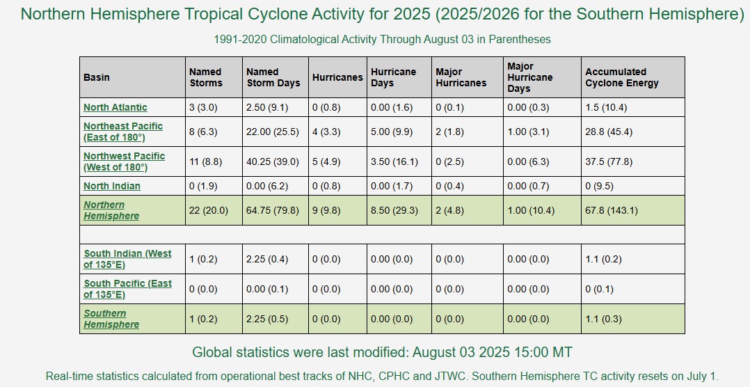
Tropical activity usually begins to increase in August, and right on cue, it is doing so, in both the Atlantic and the Pacific.
It’s been a slow start to hurricane season across the Northern Hemisphere. Image provided by Colorado State University.
After a fairly slow start to hurricane season, conditions are starting to become more favorable for storms to develop, especially across the Atlantic. We’ve had three weak, short-lived storms thus far, which isn’t that unusual for June and July, but activity usually starts to ramp up in August. Saharan dust surges, which are common in June and July, should be starting to slow down over the next few weeks. Water temperatures continue to rise, and now are above the 26C (79F) threshold needed to sustain tropical systems across a large portion of the Atlantic, especially the Main Development Region (MDR). In addition, wind shear has been rather hostile across the tropics, but that is also starting to lessen. The tropical waves moving off the west coast of Africa have been a little more robust over the past few weeks, and although none of them have developed, it is only a matter of time until that changes. This is not the only place we need to watch for storms to develop however.
There are now three areas in the Atlantic being monitored for development. Image provided by the National Hurricane Center.
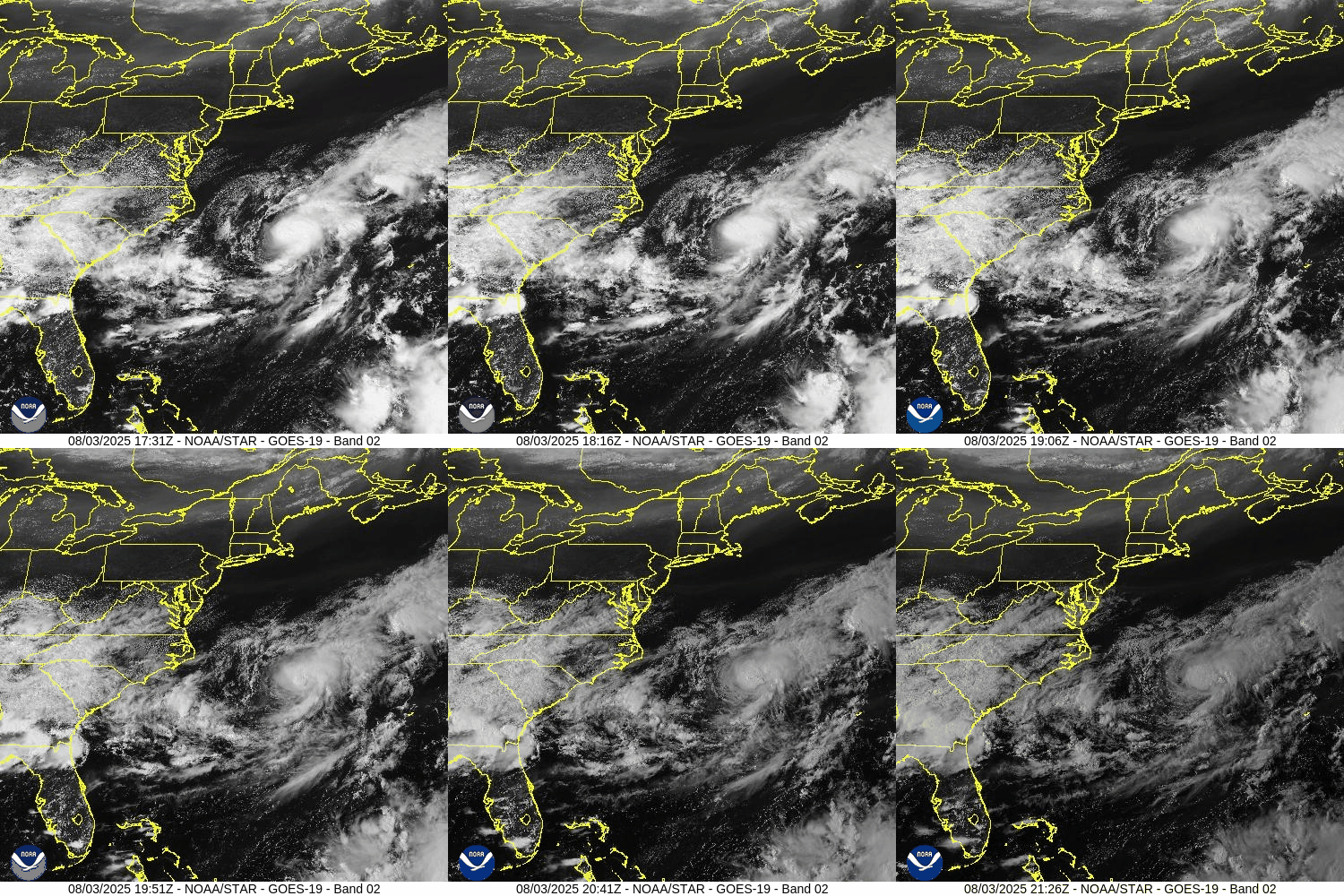
Starting off near the East Coast, a frontal system is stalled out near the Carolinas. A wave of low pressure has developed along the front, a few hundred miles off the North Carolina coastline. It is producing squally conditions in the offshore waters, and should head out to sea over the next few days. However, as it detaches from the front over the next day or so conditions will become favorable for development, and it could become a Tropical Depression or Tropical Storm over the next few days as it heads out to sea, without impacting any land areas.
Low pressure is trying to develop off the East Coast. Loop provided by NOAA.
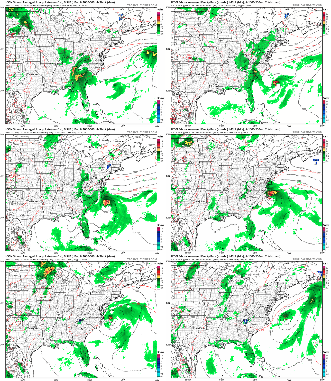
That might not be the only system we need to keep an eye on near the East Coast over the next week or so. Forecast models are showing the potential for another system to develop off the Southeast Coast later this week. Some models keep the storm weak and have it mill around near the Southeast for a few days, others are more bullish and develop the system and have it head up the East Coast, while other models have it stay offshore and head out to sea harmlessly. It’s too early to determine whether the storm will even form, never mind where it might go, but this is definitely something to keep an eye on as the week goes on.
Some models show the potential for another storm off the East Coast later in the week. Loop provided by Tropical Tidbits.
Elsewhere in the Atlantic, there are a couple of tropical waves crossing the Caribbean, but neither is expected to develop at this time. However, another wave will move off the west coast of Africa on Monday, and this one could bear watching. We already mentioned above how conditions across the Main Development Region are beginning to improve, and this wave could take advantage of those improving conditions. Many of the forecast models, especially the Ensembles, are showing significant potential for this wave to develop as it crosses the Atlantic. We’ve seen plenty of times before where the models are gung-ho with a system, and it doesn’t develop, so this is far from a lock. Even if it does develop, questions of where it goes and how strong it gets cannot be answered at this time, and probably won’t be for at least another week or so, and that’s if it even develops. Nevertheless, we’ll be keeping an eye on this wave in the coming days.
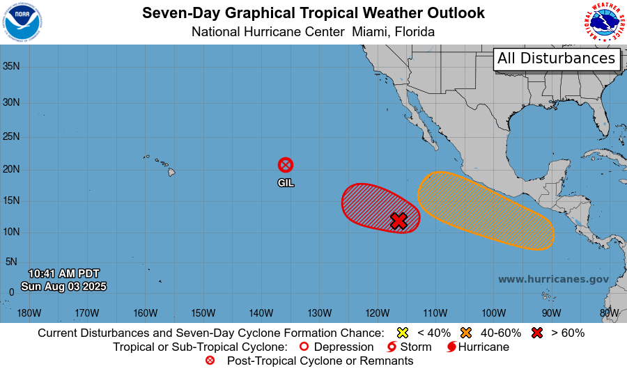
The Eastern Pacific could see more storms this week. Image provided by the National Hurricane Center.
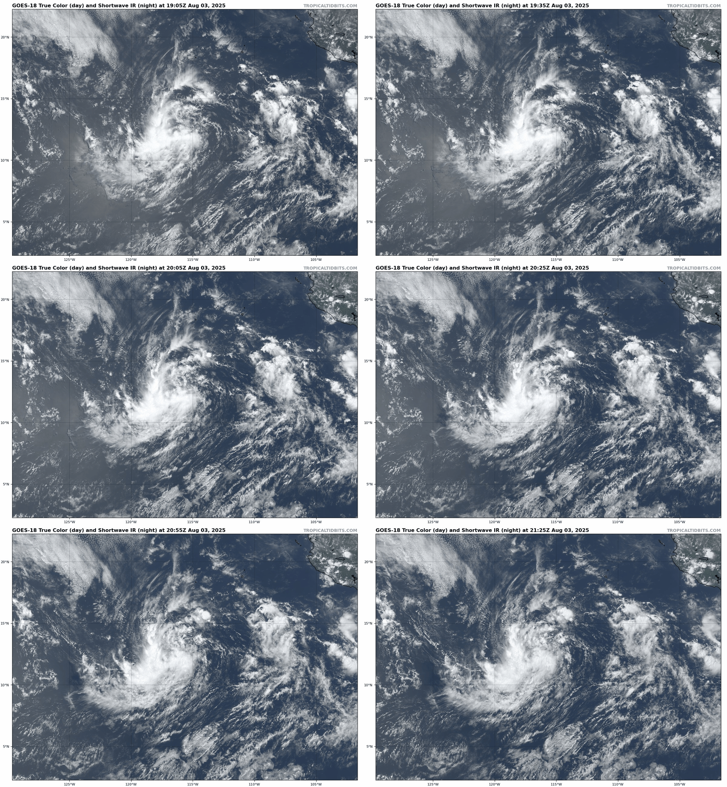
In the Eastern Pacific, where activity has been closer to normal so far this season, more storms are expected this week. Former Hurricane Gil has become extratropical halfway between Mexico and Hawaii, and will no longer be a threat. However, an area of low pressure appears to be developing several hundred miles southwest of Mexico. Conditions are favorable for development, and this system could become a tropical depression by Monday. Forecast models show the potential for it to quickly develop, possibly becoming a hurricane by midweek. After that, it will start to move over cooler water, and should start to weaken fairly rapidly. Its remnants could bring gusty winds and rainfall to parts of Hawaii in a week or so, but that is far from certain.
An area of low pressure southwest of Mexico could become a tropical depression in the next 24 hours. Loop provided by Tropical Tidbits.
Meanwhile, forecast models show the potential for another system to develop south of Mexico later this week. While the models aren’t quite as bullish on this system as they are on the one mentioned above, they do show the potential for this system to become at least a tropical storm toward the end of the week. The difference with this one is that it will form quite a bit closer to Mexico, and could be a threat to parts of southern Mexico by the end of the week.
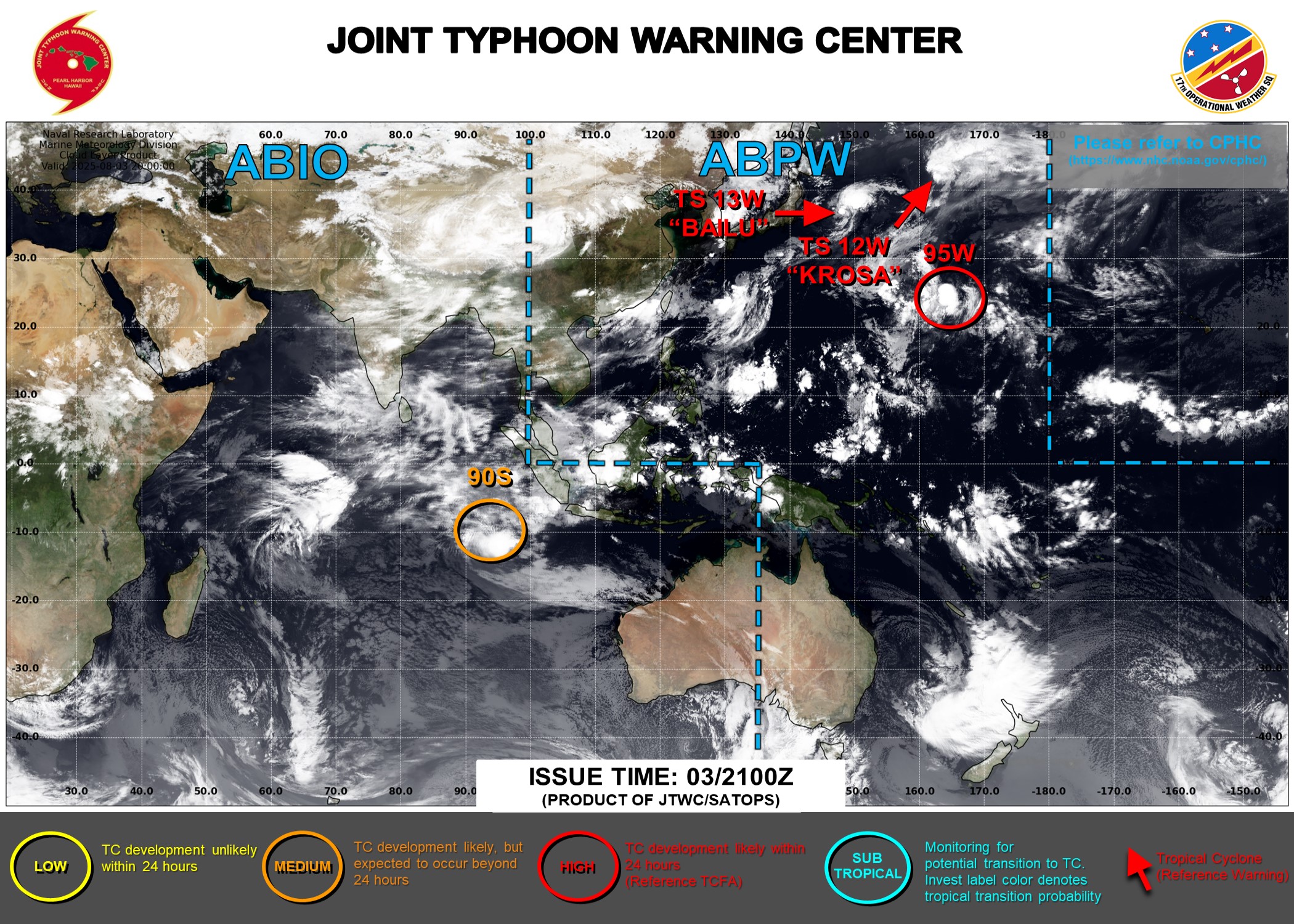
The Western Pacific is also getting more active. Image provided by the Joint Typhoon Warning Center.
In the Western Pacific there are also a couple of areas to watch. Tropical Storm Krosa is dissipating well northeast of Japan, and is not a threat to any land areas as it heads out into open water. Tropical Storm Bailu has maximum sustained winds near 40 mph, and was centered about 400 miles east-northeast of Tokyo Sunday evening. Bailu should maintain its current intensity for the next day or two, but will head east-northeastward, away from Japan and out to sea, without impacting any land areas. There is also an area of disturbed weather about 500 miles north of Wake Island that is being watched. Conditions are favorable for development, and this could become another tropical depression in the next day or so. Like the other active systems in the Western Pacific, even if this one develops, it will likely stay over open water without threatening any land areas.
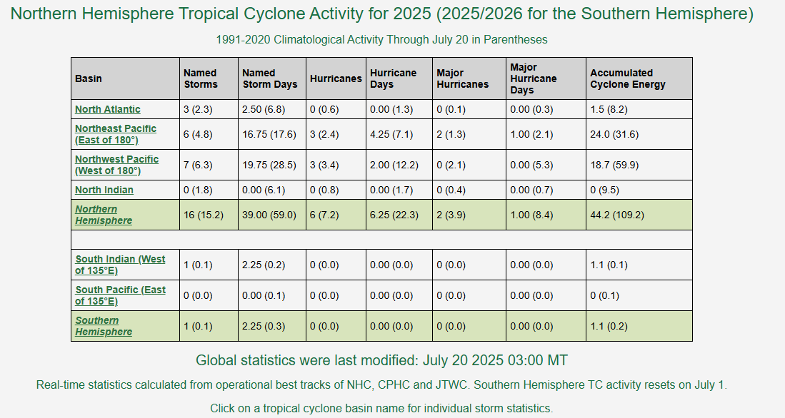
By most metrics, the first 6-8 weeks of hurricane season has been fairly quiet across the Northern Hemisphere.
Tropical Cyclone Activity has been near to below normal across the Northern Hemisphere. Image provided by Colorado State University.
Going strictly by the number of named storms, activity has been near normal across the Atlantic and Pacific, and below normal in the Indian Ocean, where no storms have developed so far this season. However, the number of storms does not tell the entire story. To get a better view of how active a season has been we use a metric called Accumulated Cyclone Energy or ACE for short. ACE is calculated for all storms that are at least tropical storm strength by summing the square of a storm’s maximum sustained wind speed every 6 hours, then dividing that number by 10,000. Using this metric, activity is running about 44% of normal across the Northern Hemisphere, and less than 40% of normal across the Atlantic.
In the Atlantic, there have only been 3 short-lived tropical storms thus far this season, and 2 of them were very weak, which is why the ACE for the Atlantic is so low. In the Eastern Pacific there have been 3 hurricanes, 2 of them major hurricanes (Category 3 or stronger), resulting in a higher ACE, but it is still below normal for this point in the season. The same holds true for the Western Pacific, where there have only been 3 typhoons so far this year.
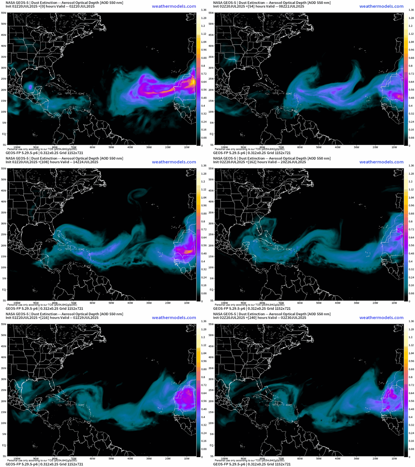
Bursts of Saharan Dust will continue to cross the Atlantic over the next week. Loop provided by Weathermodels.com
In the Atlantic, conditions have remained unfavorable for the most part, as sea surface temperatures are still a little too cool across the Main Development Region, but bursts of Saharan Dust continue to move off of Africa and across the Atlantic every few days. These bursts suppress shower and thunderstorm activity with very dry air as they make their way westward. As we get into August, the Saharan Dust outbreaks should become less numerous, and sea surface temperatures across the Atlantic should continue to rise, allowing for more favorable conditions to develop.
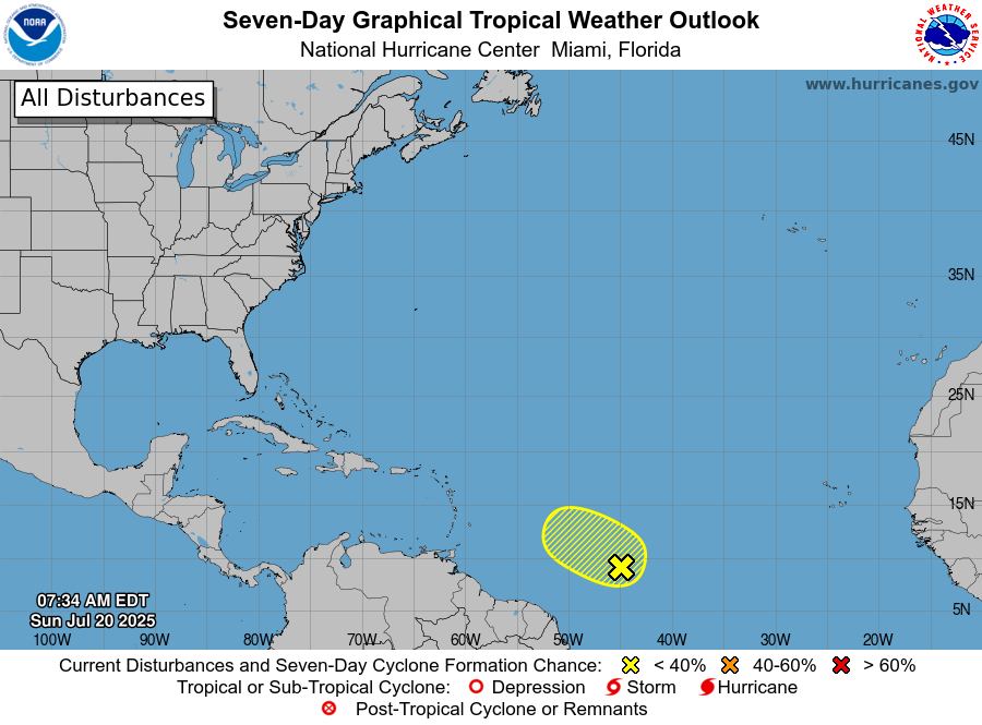
There is a very low probability that a system well east of the Caribbean could develop in the next few days. Image provided by the National Hurricane Center.
There are 2 areas that we are currently monitoring across the Atlantic at the moment, though both have slim odds of developing at this point. A tropical wave centered about 1000 miles east-southeast of the Lesser Antilles is producing disorganized showers and thunderstorms. There is a small window for some development over the next day or two, but after that, conditions will become more hostile once again, well before the wave reaches the eastern Caribbean.
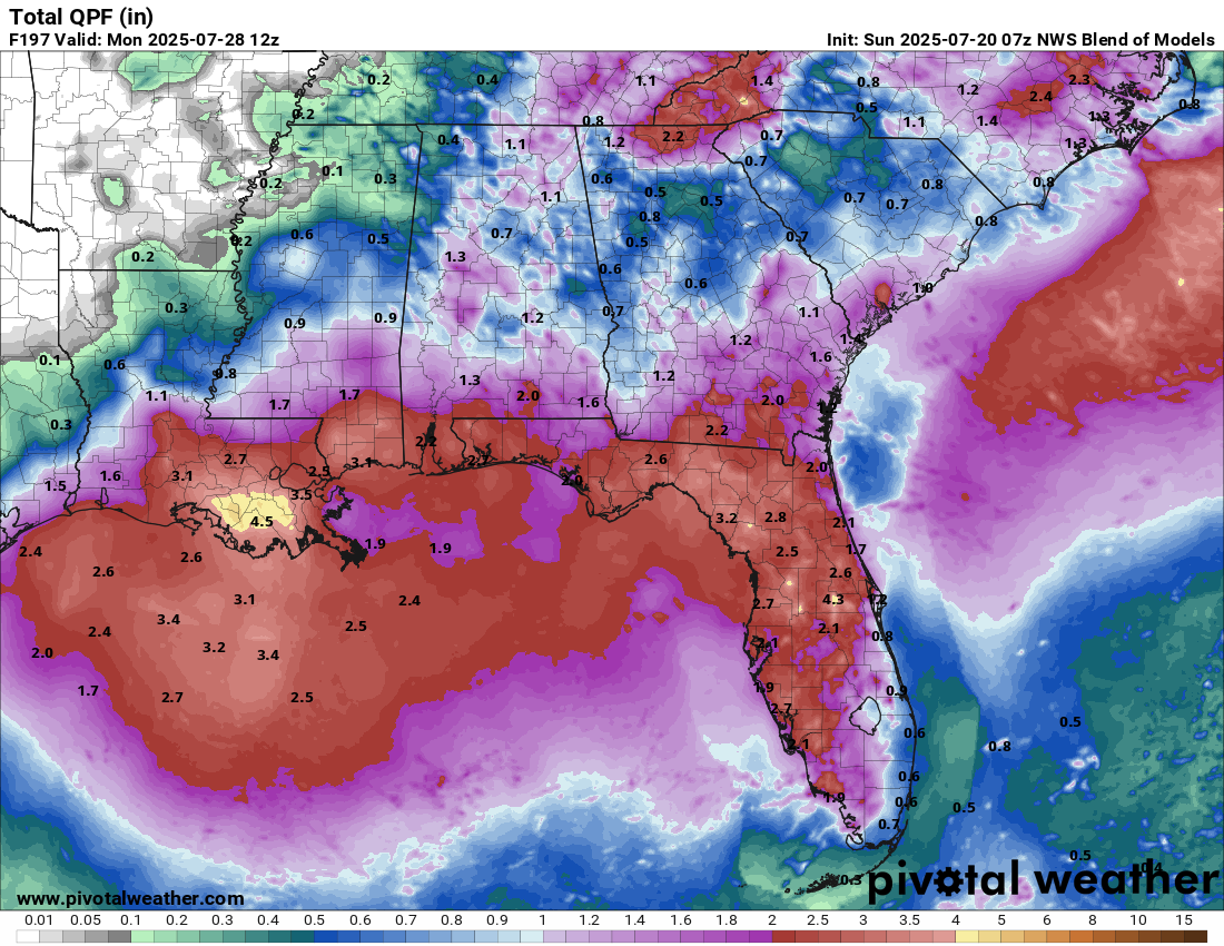
Another disturbance may bring heavy rain to parts of the Gulf Coast and Florida again this week. Image provided by Pivotal Weather.
Last week, a disturbance developed off the Southeast coast and moved westward into the Northern Gulf, producing heavy rain and flash flooding across parts of Florida and the Gulf Coast. The system did not develop before moving inland, and what’s left of it is producing showers and thunderstorms across parts of the Deep South and the Southeast. Forecast models are showing the potential for this system to move back out off the Southeast coast again in the next few days, then head westward around the periphery of a ridge of high pressure and back into the Gulf during the upcoming week, with some potential for development once again. At the very least, it will likely bring some more heavy rain to parts of the Gulf Coast, but the odds of development remain low.
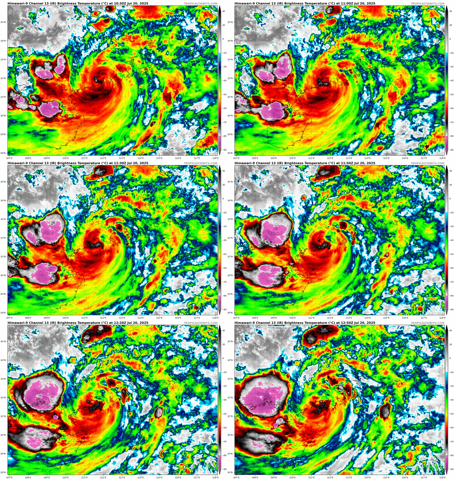
Typhoon Wipha made landfall just west of Hong Kong early this morning. Loop provided by Tropical Tidbits.
In the Western Pacific, Typhoon Wipha passed just south of Hong Kong early this morning, producing wind gusts of up to 82 mph, and dropping as much as 5-10 inches of rain on the region. After making landfall just west of Hong Kong, Wipha should slowly weaken while paralleling the coast of southern Guangdong Province today. It may emerge in the Beibu Gulf (a.k.a. Gulf of Tonkin) on Monday. If it does, it could restrengthen a little before a second landfall in northern Vietnam. Whether it does or not, heavy rain and flooding are likely across parts of Southern China and northern Vietnam over the next few days.