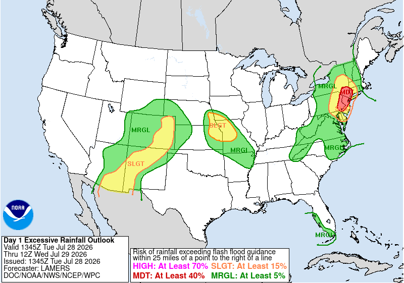
The weather pattern flips this week, bringing widespread rain and a high likelihood of flooding and flash flooding to the Northeast and Mid Atlantic.
Excessive Rainfall outlook for June 28th, with a noteable Moderate risk around New York City and New Jersey. Image provided by NOAA/WPC
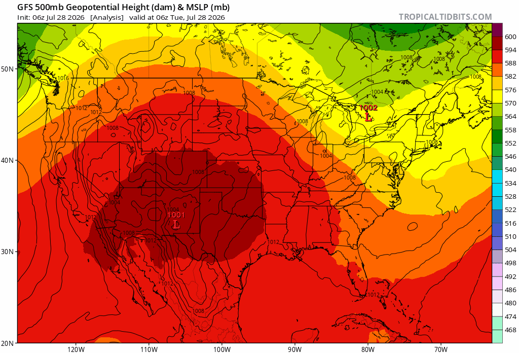
Through the 29th to the 31st of July, a strong surface low will move quickly over the northeast bringing signifigant rain across the region. On Tuesday the 28th, an upper level trough will redirect the surface low along its southern edge and off the coast as it develops into a strong cut off low – A low pressure system that is disconnected from the prevalent wind direction – that persists until Friday the 31st. While the system is moving from the west-northwest initially, the cut off low will redirect moisture from the great lakes to the southeast, before moving northward along the Atlantic coastline.
Northeast weather patterns setup for a widespread flooding event. The surface low stalls off of new england Loop provided by Tropical Tidbits.
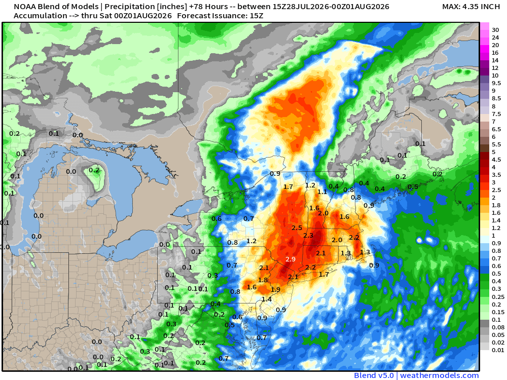
Once in place, this cut off low will remain through Friday the 31st, bringing rainfall totals between 2 and 5 inches in New York and western New England, and 1 to 3 inches further east. The movement of the surface low could see this heavy rain extend as far south as North Carolina, though the most certain area is focused around NYC and the surrounding states. Localized totals could potentially exceed 6 to 7 inches. The 29th will see most of the rainfall from this system as it sets up over the region, with follow up showers moving through eastern New England on Thursday and Friday.
Rainfall through the night of the 31st. Widespread 2-4 inches is likely, with potentially higher localized totals. Image provided by Weathermodels.com
As heavy rainfall progresses, storm drains could get overwhelmed as their capacity is exceeded. Underpasses and other low lying areas will be most suceptible to flooding as drains back up, and water levels could rise quickly. While most of this water will be standing water, it only takes a few inches for a car to become stranded. The water also wont necessarily be clean water, as ground debris is picked up by rainwater flowing into the now flooded area.
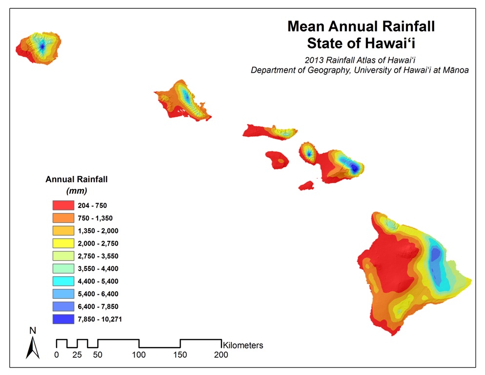
It should be no surprise that Hawaii receives the highest average annual rainfall of all the states in the US, given that it’s a set of islands in the middle of the Pacific Ocean.
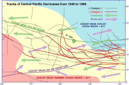
Tracks of hurricanes that have passed near Hawaii from 1949 to 1998. Image provided by the USGS
Of the islands, the “rainiest” island is debated to be between Maui and Kaua’i, with O’ahu, Hawaii (Big Island), Moloka’i, and Lana’i following in subsequent totals. Between 1912 and 1942, Mount Waiʻaleʻale on Kaua’i reported an average rainfall of 460 inches annually, and this is commonly quoted today. A more recent 30-year analysis estimates it to be around 360 inches of rain annually. Maui’s Big Bog, however, has a 30-year estimate of around 404 inches of rain, much higher than the 30-year analysis for Kaua’i.
Mean annual rainfall in Hawaii for 2013. Image provided by the University of Hawaii Department of Geography.
The geography of Hawaii creates an environment where the eastern side of each island gets most of the rainfall, while the western sides are more akin to desert-like climates; although they are islands, each is a volcanic mountain that rises much taller than one would expect. Mauna Kea on Hawaii (Big Island) has a peak of 13,803 feet tall. For comparison, Mount Elbert, the tallest US peak in the Rocky Mountains, stands at 14,440 feet when measured from sea level. This places Mauna Kea well within the upper ranges of mountain peaks if it were placed in the Rocky Mountains. However, when measured from its base, Mauna Kea is the tallest mountain in the world, whereas Mount Everest is the highest peak elevation.
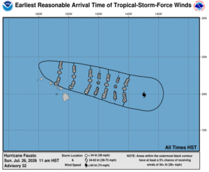
Being in the middle of the Pacific Ocean also has an effect, of course. It is often grazed by hurricanes or their remnants, though most do not make direct impacts. Most storms track south of Hawaii where equatorial Pacific waters are warmest, with outer bands or remnant storms having the most impact, placing them well outside of the normal forecast cone. Hurricane Fausto is an anomaly in this sense, as its forecast cone has it directly impacting Hawaii as a Tropical Storm. It is still too soon to determine how strong the wind and rain from Fausto will be once it reaches the islands; however, these should start to resolve as Fausto approaches the islands.
Estimated arrival of tropical storm-force winds from Fausto for the Hawaiian Islands. Image provided by the NHC/NOAA
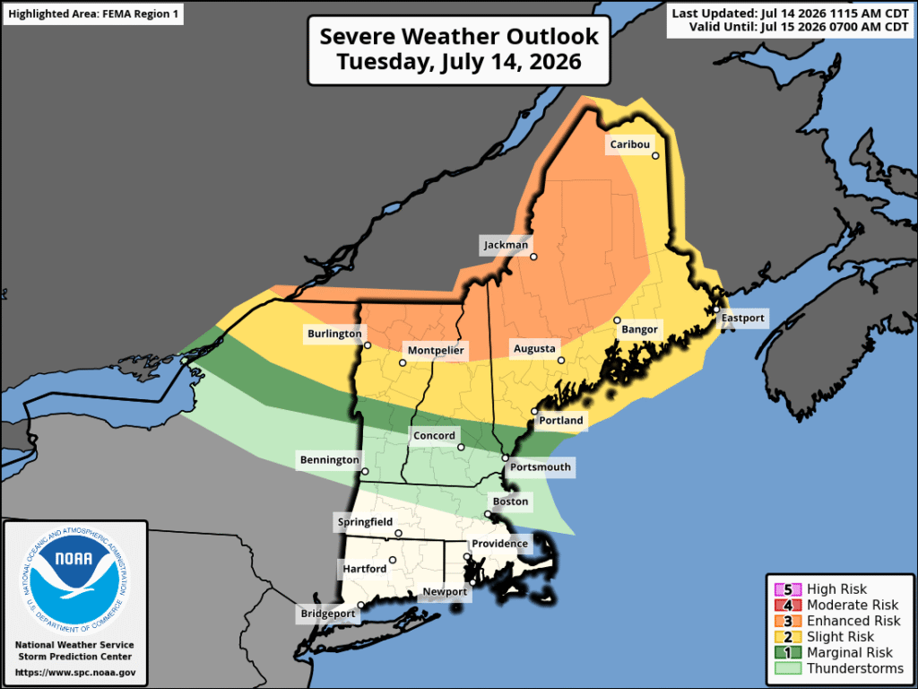
Severe weather doesn’t often make its way to the Northeast to the level that other regions of the country see. When it does, however, it generally comes from one of two directions, from the south along the coast, or from the northwest in southern Canada. The severe weather moving through today and tonight of July is one case of weather coming from the northwest.
Severe Weather potential for the Northeast on July 14th, bringing a risk of tornadoes, wind, and hail to the region. Image provided by NOAA
Weather from the northwest is generally hindered by a lack of humidity, as the further northward you move, the less available moisture there is. The less moisture, the less available total energy there is for storms to form, whereas weather from along the coast generally is limited by the ocean as systems leave New Jersey and pass over both the ocean and Long Island before impacting parts of New England.
Relative humidity from Tuesday the 14th to Wednesday the 15th. Loop provided by Weathermodels.com
Wildfires also play a part in this, as the smoke from them gets high into the atmosphere, injecting drier air, but they can also promote storm formation if particulate that is released by them manages to mix with more moist air. Wildfires in Ontario are the source of the smoke for the next few days.
Canadian wildfires lifting dry air and smoke and dry air into the atmosphere, hindering ground heating needed to form significant storms. Loop provided by Weathermodels.com
For the current storms moving through, wind, hail, and tornadoes are all expected to be on the stronger side when they occur. Most of the severe threat is limited to areas that are generally less populated in northern Vermont, New Hampshire and Maine, though this does not mean that severe weather won’t move into more populated regions, and a system could move through southern New Hampshire overnight on the 14th into the 15th, bringing showers and strong winds, with the potential for hail and tornadoes as the night progresses.
Storms moving through New England on the 14th overnight in to the 15th. Loop provided by Tropical Tidbits
Cooler and drier air will move into New England on July 15 behind a cold front.
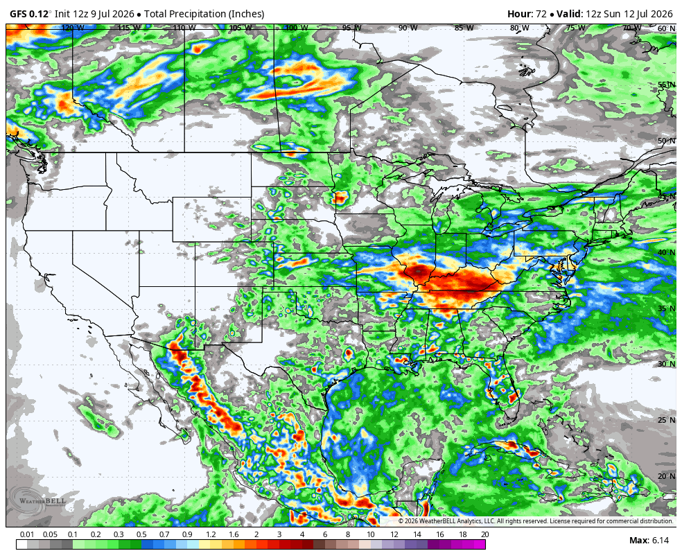
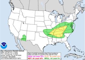
The weekend of the 10th will bring excessive rain and flooding to the Ohio Valley, Heat to the Midwest and Southwest, and near-average conditions for the Northeast.
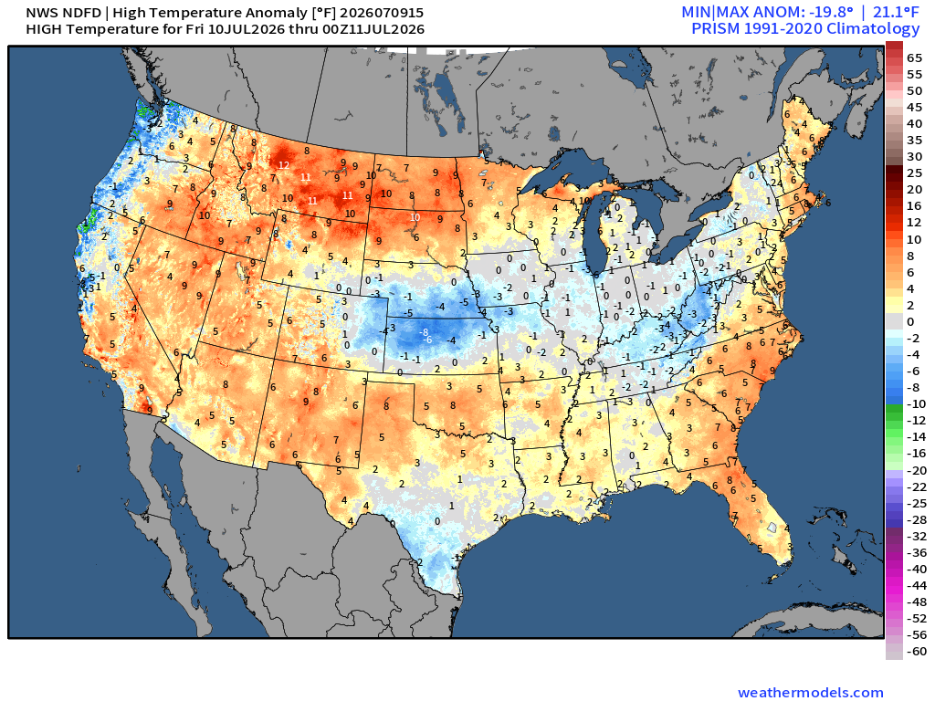
An upper level ridge will move into the northwestern US, bringing high temperatures in the 100s to the northern Rockies. Image provided by Tropical Tidbits
For Friday, highs across the country will be in the 80s and 90s, with lows in the high 40s to low 60s across the northern US and the eastern Rockies, while the southern and central US will see 70s into the low 80s. Much of the country will be near normal for this time of year. Central Kansas will be on the cooler side, around 8 degrees below normal as a surface front moves southward, while the Northern Rockies will be 10 degrees above average for both high and low temperatures. Light showers can be expected across the eastern US, with the southern Ohio Valley seeing localized amounts of 1 to 2 inches of rain. The southwestern and western US also face an elevated risk of fire as moisture moves out of the region.
High temperatures for most of the country will be within 5 degrees of normal, though the Northern rockies and the Central Plains stand out as above and below respectively. Image provided by WeatherModels.com
For Saturday, much of the southern and western US could see high temperatures in the high 90s to above 100 degrees as an upper level high settles over the region. The Northern Rockies are notably warm, with temperatures almost 20 degrees above average across Montana and North Dakota. Saturday will see continued rainfall in the southern Ohio Valley into the Mid-Atlantic as the front moves southward, with scattered showers continuing through the weekend. Southern Indiana and Tennessee could see localized totals between 2 and 4 inches, causing flash flooding, with 2-day totals reaching up to 6 inches.
Rainfall totals across the eastern US will be less than an inch, with the Southern Ohio Valley and northwestern Mid-Atlantic receiving 3 to 6 inches of rain. Image provided by WeatherBell
In the Northern Rockies, where temperatures are well above average, extreme heat warnings are in effect, and local daily records are likely to be set in many cities. Outdoor activities are recommended to be minimized where possible, and plenty of water and breaks are recommended where not. In the southern Ohio Valley and northwestern Mid-Atlantic, a slight risk of excessive rainfall persists with storms Friday and Saturday, when flash flooding is most likely.
Areas across the Tennessee and Ohio Valleys are at risk of flooding as a result of excessive rainfall. Image provided by the Weather Prediction Center.
On Sunday, highs in the northeast will remain in the 80s and 90s in the southeast. The Southwest and the Rockies will remain 10-15 degrees above normal, with highs in the upper 90s to above 100 degrees from southern California to Montana and the Dakotas. Up to 1 inch of rain is expected as the storms move deeper into the Mid-Atlantic, with Eastern Kentucky, Western Virginia, and the Carolinas potentially seeing localized rainfall of up to 3 inches. Most of the southern US will also see light showers through the day.
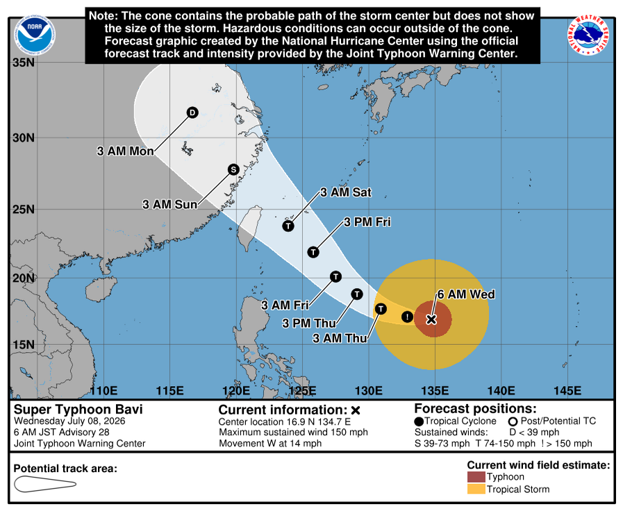
While the United States was celebrating its 250th birthday on the 4th, the Northern Mariana Islands were ravaged by Super Typhoon Bavi, which crossed the tiny island of Rota with the strength of a Category 5 hurricane on July 5th.
While storms of this strength might be devastating for the United States and parts of the Caribbean, areas in the Western Pacific, including the Northern Mariana Islands, and countries such as Japan, Taiwan, and China have had the time to build up infrastructure and procedures to mitigate the impacts of these storms.
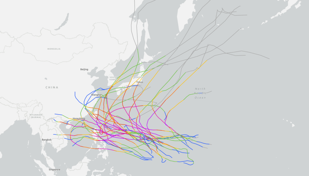
Map of the 30 most recent (satellite estimated at any point) Category 5 equivalent Super Typhoons in the Western Pacific. Many storms in the Pacific may approach land, but most remain at sea. Image provided by NOAA.
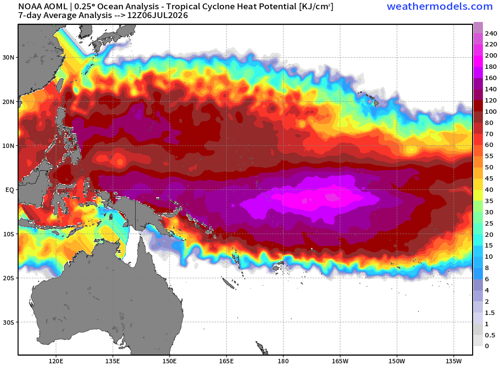
By far the biggest difference in the Western Pacific tropical season and the Atlantic tropical season is the length of the season. While the Atlantic season officially runs from June 1st to November 30th, the Western Pacific “season” runs all year, however the frequency of storms in the summer is larger compared to the winter. With a stronger El Nino, such as this year, the region for storm formation extends much further east than it does normally. Any storms that form in this extended region are likely to become Category 4 or 5 equivalent if other conditions are favorable, as they will have even more time over very warm water.
Tropical Cyclone heat potential is currently shifted east into the Central Pacific due to El Nino, allowing storms to form further into the Pacific than they normally would. Image provided by Weathermodels.com
This is also not the first Super Typhoon to have affected the Northern Marianna Islands this year. Super Typhoon Sinlaku impacted the Mariana Islands in April 2026, passing directly over Saipan, and while it did bring significant damage to the region, the most significant effect of Sinlaku was the damage to the power grid, and to buildings such as sheds or other outbuildings, as well as minor damage to the roofs of some commercial buildings. Despite the collapse of the power grid in the Northern Mariana Islands, power was restored to a majority of the island in just 3 days.
The island of Rota was directly hit by the eye of Bavi, causing widespread damage to the island. The National Weather Service expects all trees and powerlines to be snapped, causing the island to be potentially uninhabitable for weeks as recovery efforts get underway. The airport on the island was approved for emergency use, improving recovery efforts through the island. Super Typhoon Bavi remains as Category 4 equivalent storm into the Philippine sea, and is expected to impact Taiwan by early Saturday and eastern China early on Sunday local time.
Super Typhoon Bavi will be an increasing threat to Taiwan and eastern China later this week. Image provided by the National Weather Service office in Tiyan, Guam.
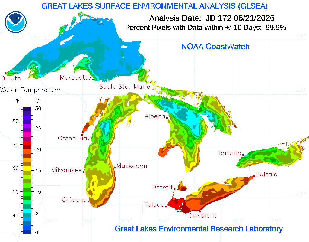
Halfway through June, and the Great Lakes surface temperatures range from average to well below average. From Lake Erie being the shallowest, and Lake Superior being the largest, they play a large part in controlling the climate of downwind regions.
Lake superior is well below average temperature for this time of year, while other lakes are sitting just below average or right around it. Image provided by NOAA
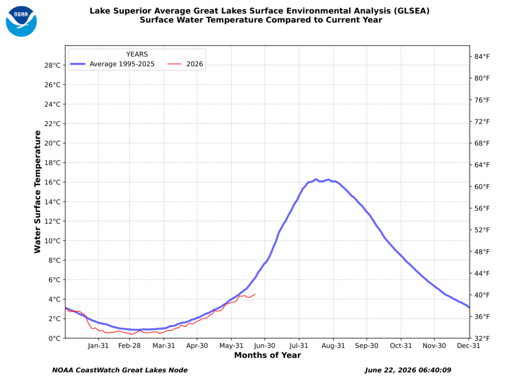
Befitting of its name, Lake Superior is the largest of the Great Lakes. Acting as a barrier between northerly winds and the Upper Peninsula of Michigan, Lake Superior helps keeps temperatures cool and assists in stabilizing the weather, though if conditions are setup just right, it can bring heavy lake effect snow to those same locations. In June, Lake Superior’s surface temperatures are below average, resting below 40 degrees across the lake. At this time of year, Lake Superior is typically in the lower to mid 40s.
Lake Superior average temperatures at this time of year range in the low to mid 40s. Graph provided by NOAA
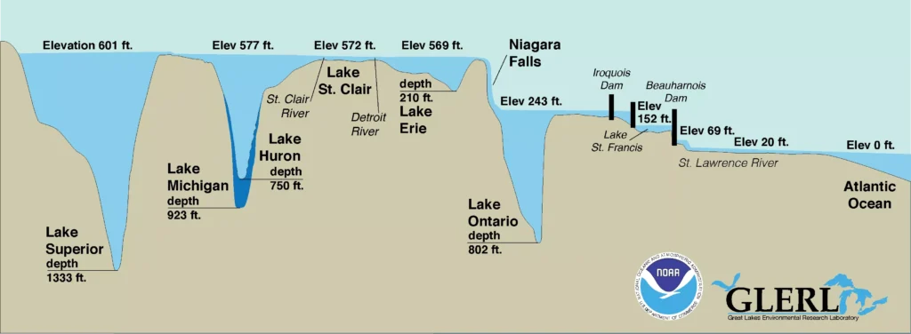
Lake Superior is the deepest of the great lakes sitting at an average of 483 feet. Its deepest point sits 1332 feet below its surface, deep enough to submerge the Empire State building, not including its spire. But not all of the great lakes are this deep. Lake Erie holds the title as the shallowest of the Great Lakes, sitting at a mere 62 feet deep on average. Its deepest point rests at 210 feet.
The Great Lakes vary greatly in depth, with Lake Superior sitting at 1332 feet at its deepest, and Lake Erie at 210 feet at its deepest. Image provided by NOAA
In relation to its low average depth, Lake Erie has the warmest temperature on average, as its thermal reservoir of water is much shallower than that of the other great lakes. Lake Erie is currently sitting at mid to high 60s, which is right on average temperature for where it should be for mid June. It also cools the quickest, allowing ice to form on it earlier than any other lake.
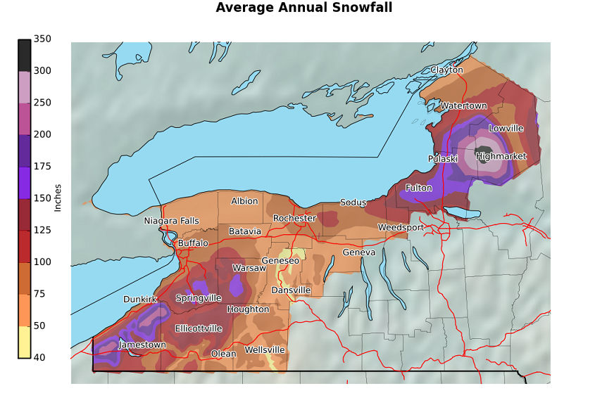
Lake Ontario Produces the most lake effect snow of the Great Lakes, though Lake Erie and Buffalo, NY typically make the news more. In the winter of 2025-26, Lake Ontario produced nearly 27 feet of snow near Worth, NY in the Tug Hill region. Lake Effect Snow is created when cold, dry air moves over the still warm waters of the great lakes. Warm, moist air then quickly rises and condenses, falling as snow once the source of heat has left, most commonly over the opposite shore from the wind.
Annual Snowfall Averages for the southern Great Lakes region in New York, highlighting how Lake Ontario creates more lake effect snow than Lake Erie. Image provided by the Buffalo, NY forecast office
Lake Huron, While not being the largest of the Great Lakes, holds the title of longest shoreline, accredited in part to the more than 30,000 islands that it hosts, most of which are in the Georgian Bay or in Ontario, Canada. When conditions are just right, Lake Huron helps to fuel immensely long snow bands, increasing the snow from both lake Erie and Lake Ontario.
Lake effect snow across the Great Lakes region, showing how the subsequent lakes can reinforce downstream snow. Image provided by CSU/CIRA and NOAA.
Finally, Lake Michigan is generally the most well known of the Great Lakes. All of the Great Lakes also produce lake breezes, where wind flows from the Lakes onto land, cooling shorelines significantly. They occur when land and air temperatures are much warmer than water temperatures, and there is little wind to slow development. Lake breezes cool coastlines between 10 and 20 degrees, reaching 30 degrees if they are strong enough.
Lake breeze around the southern half of Lake Michigan. The strongest cooling is seen in Wisconsin, at 59 degrees in Milwaukee. Image provided by Weathermodels.com
The Great Lakes are both a cultural corner stone and a significant weather component in North America. They provide cooling effects in the summer and heating effects in the winter, creating a more temperate climate surrounding them, as well as allowing for easy transport of goods across the region.
June 18th saw Tornado Watches across New England as severe thunderstorms moved through the region. The result: no reported tornado touchdowns.
Tornado Watch issued for New Hampshire, and portions of Massachusetts, Connecticut, and Maine. Image provided by NOAA
The difference between a watch and a warning may not be immediately clear. As an example, if you were going to a cookout or other event, and someone issued a “Taco Watch”, what they mean is that all of the ingredients for tacos are present, though you might not have them. A “Taco Warning,” on the other hand, would mean that you should expect tacos to be served at the event. For the Tornado Watch on June 18th, all the ingredients for tornadoes were present. CAPE, or upward atmospheric instability, low CIN, or atmospheric stability, a high dew point, and moderate lower and upper level wind shear. The final ingredient is a lifting mechanism, usually warm ground or a front. For the tornado watches that were issued in New England on the 18th, there was not enough lifting action and CAPE for tornadoes to develop into significant systems.
Cross section of a supercell with a tornado, showing the interaction between the updraft and downdraft. Image provided by UCAR and Paul Markowski, Penn State University
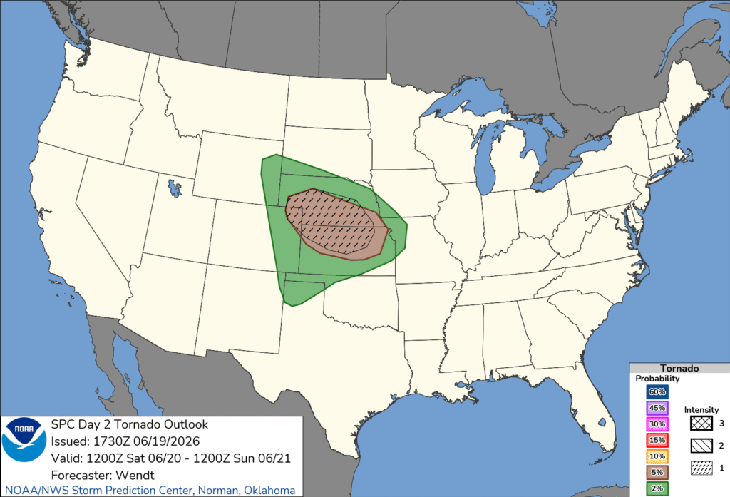
The current most significant tornado threat on the weekend of the 19th to the 21st is on the 20th. With severe weather moving through the Central Plains, all of the ingredients are looking to be in place for strong tornadoes in Kansas and Nebraska. Warm, moist air is expected to move northward, interacting with denser cool air from the north. The upward motion helps to start severe storms, while wind shear creates the necessary components of tornado genesis. In Nebraska and Kansas, the conditions for tornadoes are somewhat favorable (currently 5-9% chance of a tornado within 25 miles of a point in the red), but there is enough vertical atmospheric motion that in the level 1 conditional hatched region, a tornado has a 30% chance of being EF2+, meaning if a tornado does form, it has a 1.5-2.7% chance of being EF2+ strength.
Tornado probabilities for SPC Day 2 outlook from June 19th for June 20th, 2026. Image provided by NOAA.
Tornado watches might be issued throughout the day in the region as these severe storms move through. Severe thunderstorm warnings will lead storm fronts as they move inside larger tornado watches. If rotation is seen on radar or a tornado is reported, a warning gets issued for the expected path.
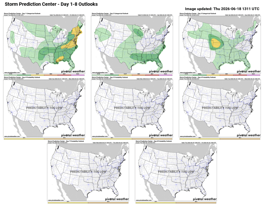
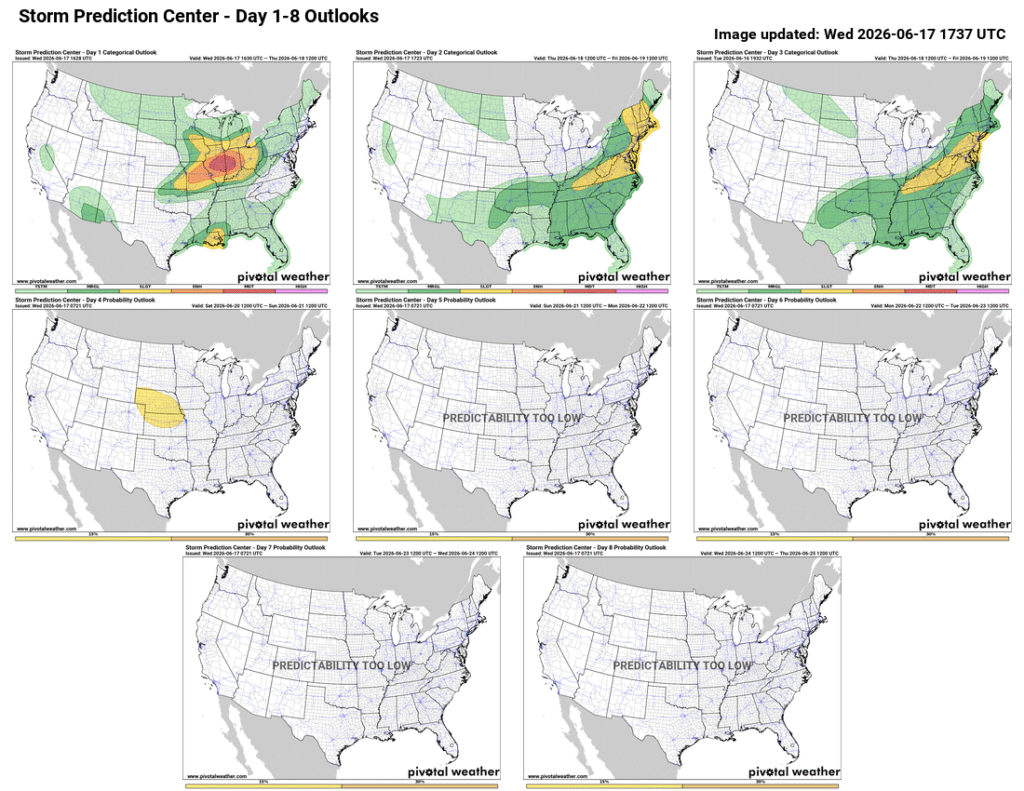
The weekend of June 19th through the 21st is a busy one, with both Juneteenth and Father’s Day. While most areas are expected to remain quiet over the weekend and into next week, the central US could see severe weather on Saturday the 20th into Sunday the 21st.
SPC outlook for the week starting June 18th for the next 8 days. Image provided by Pivotal Weather
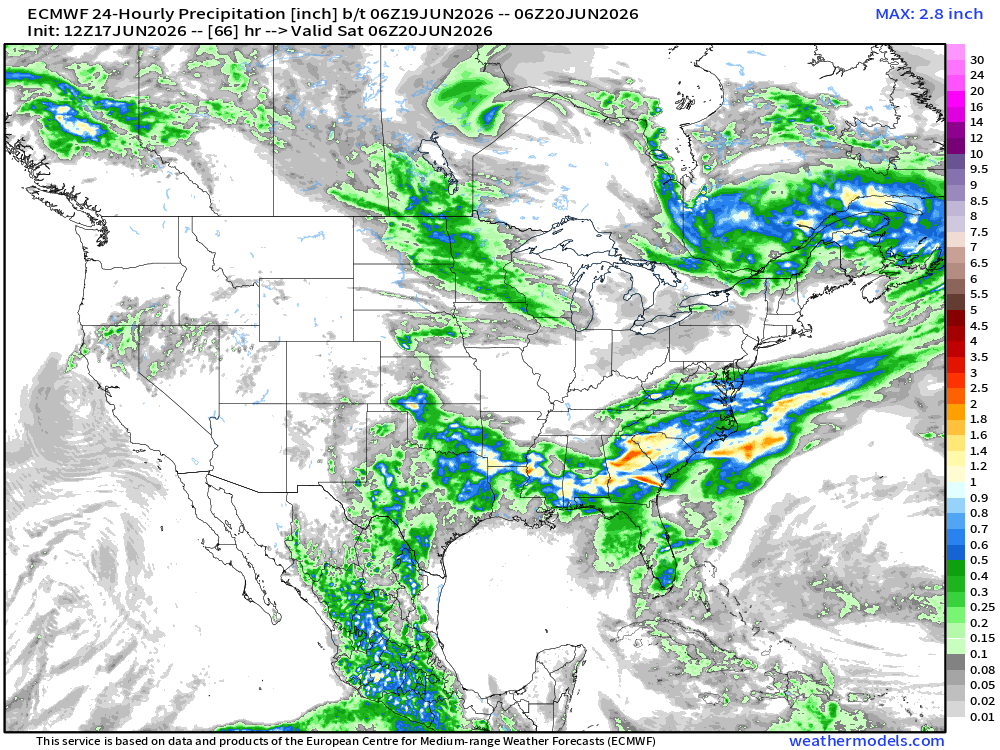
Starting Friday, June 19th, the Western US should see clear skies, though it will remain on the warmer side in the Southwest, Southern Plains, the Central Great Basin, and California. The Eastern US will see cooler temperatures with widespread rain. As the remnants of Andrew move through the Lower Mississippi Valley and Southeastern US, excessive rainfall is expected, bringing 6 to 7 inches of rain across the region. Locally higher or isolated systems may bring 10-15 inches of rain, and potentially even 20+ inches, causing significant flash flooding when they occur.
Rainfall across the US for Friday, June 19th. Image provided by Weathermodels.com
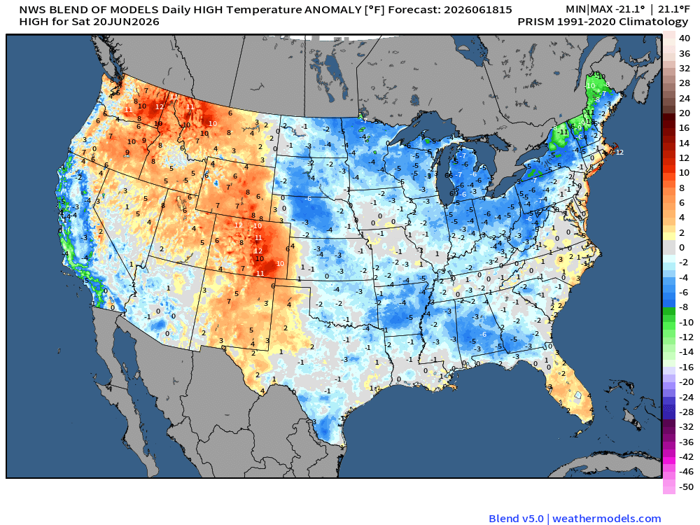
On Saturday, much of the US is expected to see sunshine with some clouds, with some scattered showers across the Northwestern and South Central US. Temperatures across the country are expected to be near average, with the 80s and 90s in the south and California, and the mid-70s in the north. The Northeast is expected to see temperatures in the 60s, while temperatures across the Rockies are expected to be well above normal.
Temperature anomalies across the US, representing the expected temperature compared to the average for the time period. Image provided by WeatherModels.com
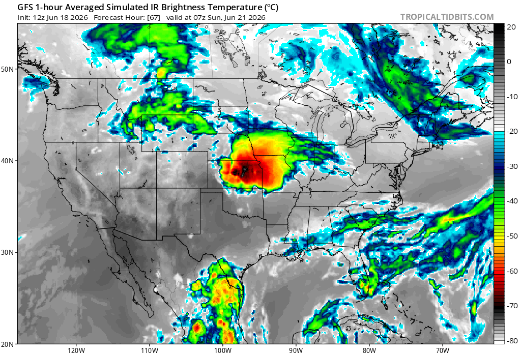
Overnight into Father’s Day, the Southwest US and California should see clear skies and average temperatures. Overnight from the 20th to the 21st, severe weather is expected to develop in Kansas before moving into the central plains, bringing tornadoes, hail, severe thunderstorms, and wind. The Simulated IR image represents cloud column height, with darker colors indicating higher cloud tops. and more energy available for storms.
Simulated IR images on Sunday, highlighting potential severe weather in the central plains.
After a calm weekend following the severe weather the week of June 7th, Severe weather returns to the Midwest this week.
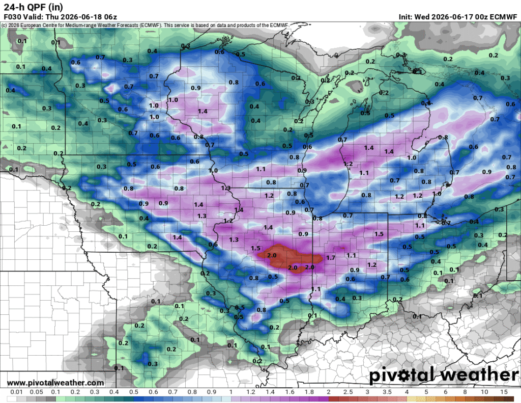
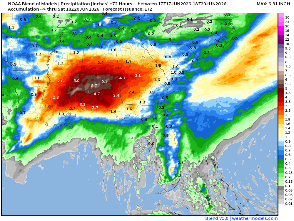
Rainfall totals in the Midwest on June 17th, with most of the region getting between 1 and 2 inches of rain. Image provided by Pivotal Weather
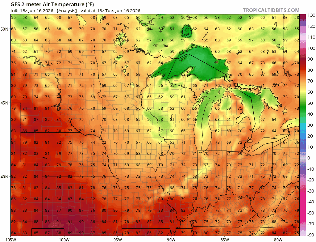
A low pressure system is sweeping through the Midwest along the jet stream, meeting warm Atlantic moisture as it does, bringing severe thunderstorms, wind, hail, and tornadoes as they collide. Fortunately temperatures are expected to remain cool in the Midwest, with highs in the 60s and 70s, and lows in the 50s between the the 17th and the 20th.
Temperatures in the Midwest to remain in the 60s and 70s from the 17th to the 20th. Loop provided by Tropical Tidbits
Severe weather, including tornadoes, hail, wind, and thunderstorms, are expected to remain in the region today, moving into the Northeast on Thursday.
Severe weather remains in the Midwest on the 17th before moving east. Image provided by Pivotal Weather
In the South, a large region of moisture is expected to bring excessive rainfall to to the area as it moves inland before combining with the system in the north. Southeast Mississippi and Southern Alabama are expected to get up to 5 or 6 inches of rain from the night of the 17th to the 20th with strong winds and flash flooding as the main risk, and a slight chance for tornadoes.
Tropical Storm Arthur to bring up to 6 inches of rain in southern Mississippi and Alabama from the 17th to the 20th. causing wind damage and widespread flash flooding. Image provided by Weathermodels.com
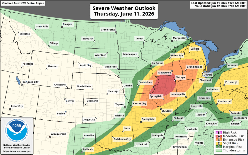
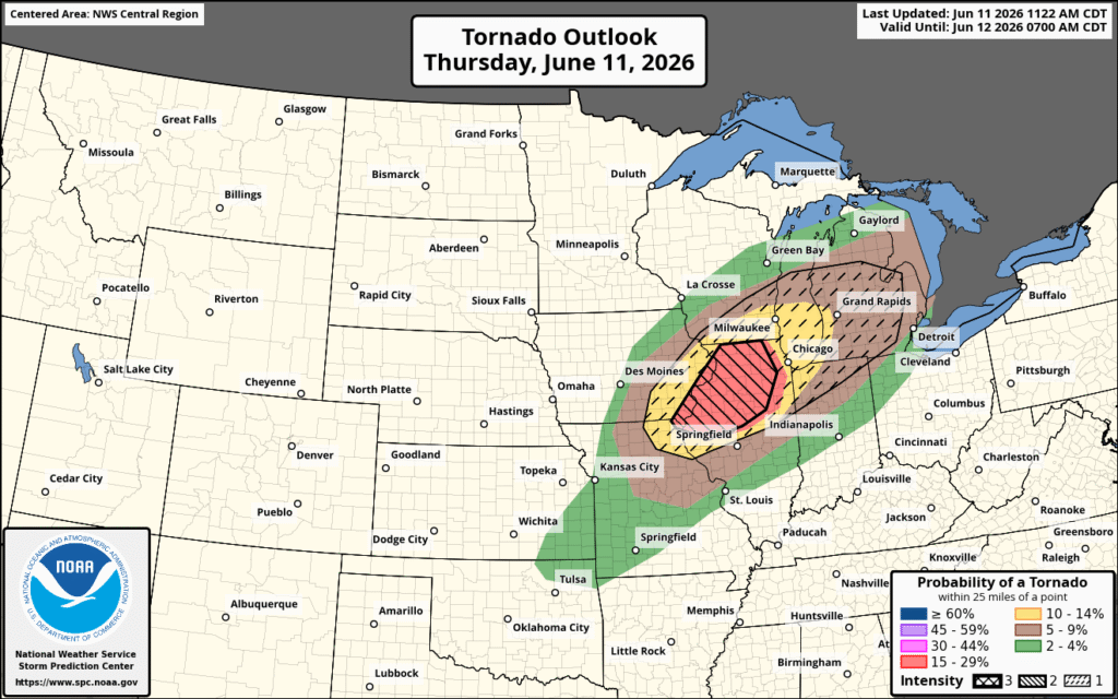
Severe Weather is continuing today and tonight in the Midwest, with a moderate risk of severe weather, up from yesterday’s enhanced risk. There is also an enhanced risk for both wind and tornadoes, with Northern Illinois and Southeastern Iowa under the greatest risk.
Severe weather continues with an upgraded risk in the Midwest. Image provided by NOAA
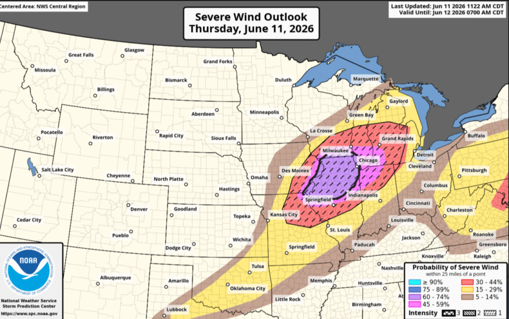
Starting in the Midwest, and the region of moderate severe weather, wind and tornadoes are the greatest threats. Northern Illinois is currently at the highest risk, with a 60-74% chance of destructive winds at any point within 25 miles of a location in that region. Northwest Indiana has a 45-59% risk within the same 25-mile range. The hatched region indicates elevated risk of 75 mph gusts, up from 50 mph in non-hatched areas, from downbursts or microbursts that can down trees or power lines, tear shingles off of roofs, and potentially destroy smaller and less structurally sound buildings.
Wind risk for the Midwest, with a hatched (75mph risk) covering much of the region. Image provided by NOAA
Northern Illinois has the highest risk of tornadoes, with a 15-29% chance of a tornado within 25 miles of any point in the dark red-shaded region. This region also has an elevated risk of a tornado being at least EF3, indicated by the left-leaning hatched region. Michigan, Missouri, Iowa, and Wisconsin have a 10-14% risk of a tornado, again within 25 miles of a point in the yellow shaded region. The dashed-hatched region indicates an elevated risk of a tornado being at least EF2 and extends across Michigan beyond the 10-14% risk. Tornadoes include all of the high-end wind threats and now also include potentially flipped vehicles or significant damage to well-built structures. Hail is also likely, with northern Illinois and northeastern Missouri potentially seeing 2-inch hail.
Tornado risk is centralized in Northern Illinois. The left-tilted hatched region represents a high potential of EF3 tornadoes, and the dashed EF2. Image provided by NOAA
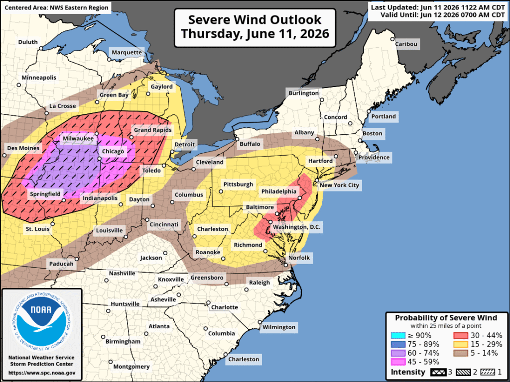
Moving over to the northeast, the greatest threats in this area tonight is wind and hail. Washington, D.C., Baltimore, and Philadelphia are at the highest risk, with a 30-44% chance of severe wind, while New York is just outside it in the 15-29% range. While coastal cities are used to strong sea breezes being amplified through narrow urban corridors, severe wind generally blows in a different direction than expected and is stronger than a simple sea breeze. Severe Hail is also expected, with a 5-14% chance of quarter-sized hail across the northeast.
Wind risk in the Eastern US is centralized around coastal cities, though it extends across Pennsylvania. Image provided by NOAA