A rather potent storm system will bring a variety of weather to the eastern third of the United States over the next few days.
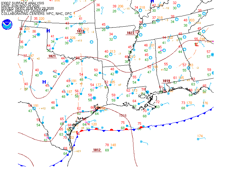
Low pressure developed along a frontal system in southern Texas on Saturday, and it will slowly strengthen as it moves northeastward tonight and Sunday. As it strengthens, it will draw moisture northward from the Gulf of Mexico, while colder air continues to move southward behind the storm system. This will set the stage for a couple of rather active days across the Eastern third of the nation, with several different types of weather likely.
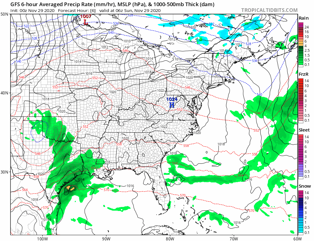
The biggest threat initially will be severe weather. As the warm, moist air flows northward from the Gulf of Mexico and clashes with the colder air moving in behind the storm, strong to severe thunderstorms are possible. A few storms are possible overnight in parts of Texas and Louisiana, but the threat will shift into the Gulf Coast on Sunday, parts of the Southeast and the Carolinas Sunday night, and parts of the East Coast from Florida to the Mid-Atlantic states on Monday. Some of the stronger storms may produce heavy downpours, damaging winds, and possibly some tornadoes.
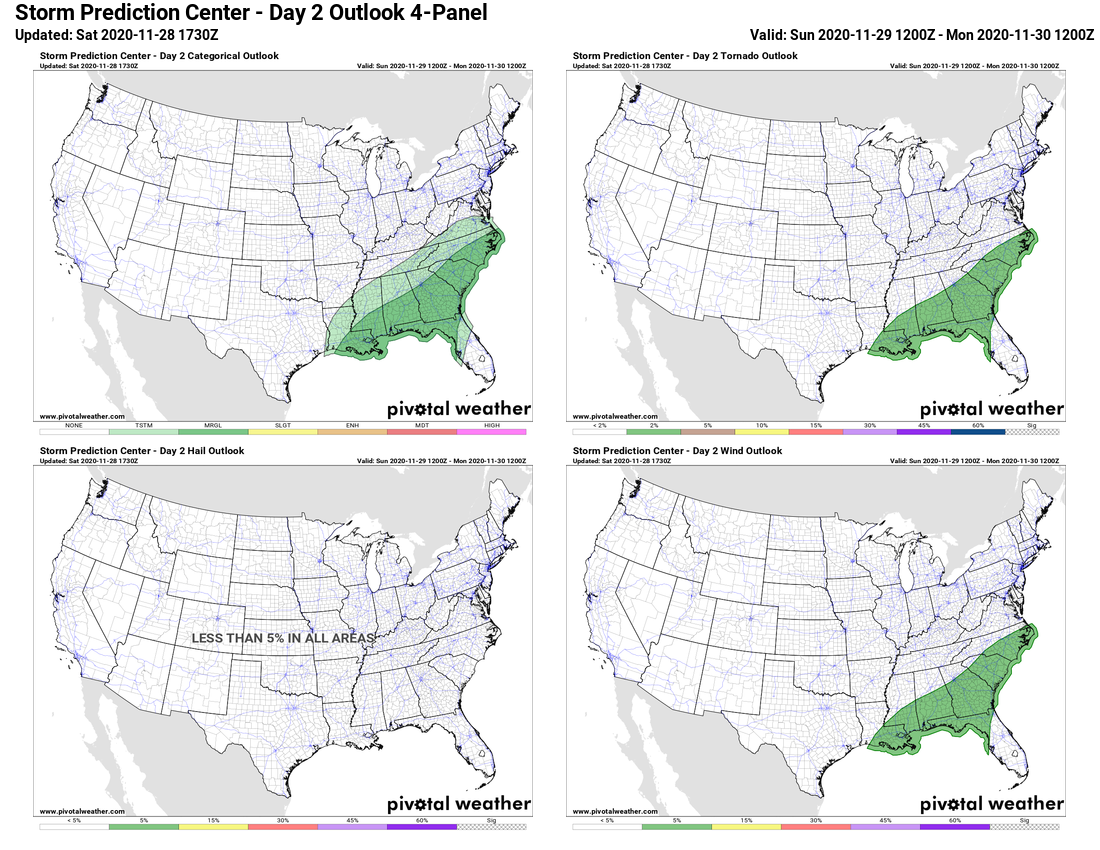
While severe weather is not common at this time of year, it is certainly not unheard of. In fact, Saturday marked the 32nd anniversary of one of the strongest tornadoes on record to hit North Carolina. On November 28, 1988, an F4 tornado tore an 84-mile path of damage across parts of North Carolina, including the city of Raleigh.
#OTD the 1988 Raleigh EF4 tornado tore an 84 mile path of destruction through central NC. While it’s getting colder, severe weather is still possible and worth keeping in mind with a storm system moving in Sun night into Mon. Have memories of this event? Share them below! #NCwx pic.twitter.com/uoapXwtaTp
— NWS Raleigh (@NWSRaleigh) November 28, 2020
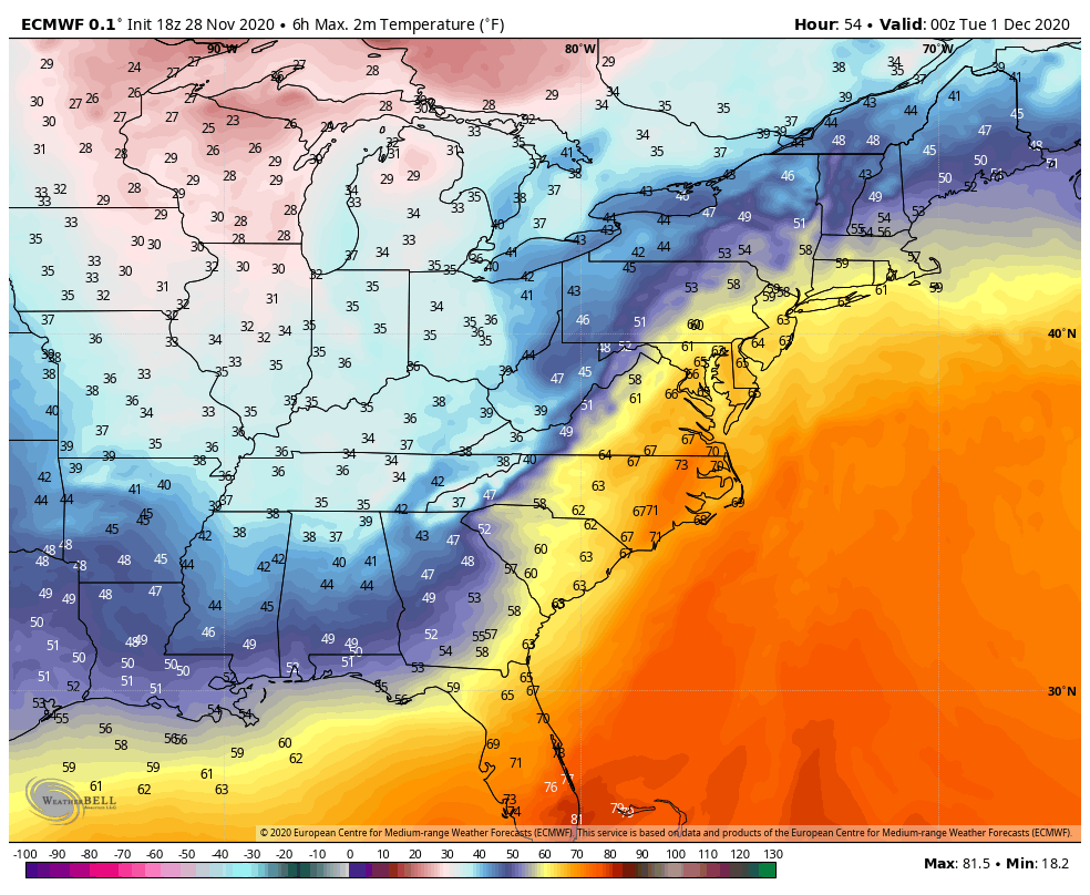
As the storm moves up the Appalachians it will bring unseasonably mild air to the East Coast, but also some heavy rainfall. Temperatures will be in the 60s and 70s across the Gulf Coast and Southeast on Sunday. By Monday, 60-degree readings will be possible as far north as southern New England, with some 70s into the Carolinas and parts of southern Virginia. The mild air may linger into Tuesday across parts of New England as well. While these temperatures are 10-20 degrees above normal, they will likely fall short of the record highs in most locations.
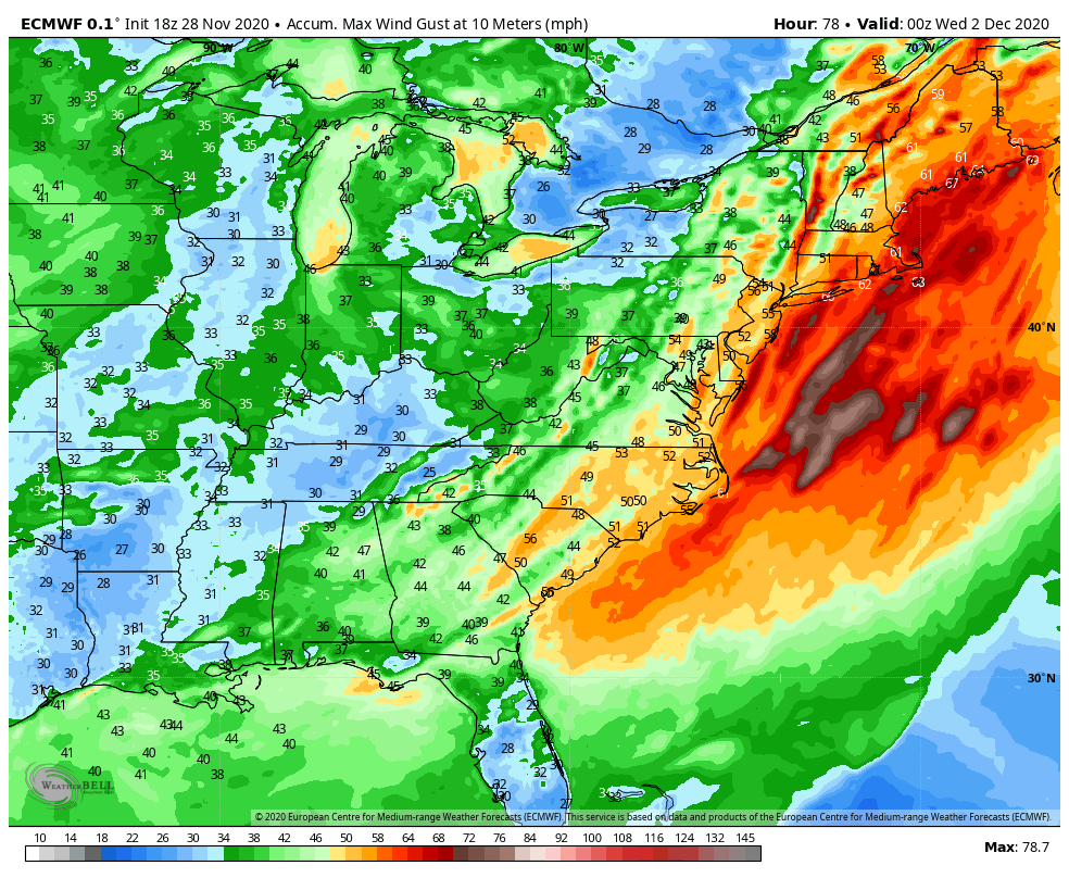
The warm weather will be transported in by strong southerly winds ahead of the system. Sustained winds of 25-35 mph will be common up and down the East Coast. Many places could see wind gusts of 50-60 mph or stronger, which could lead to power outages as trees and wires come down.
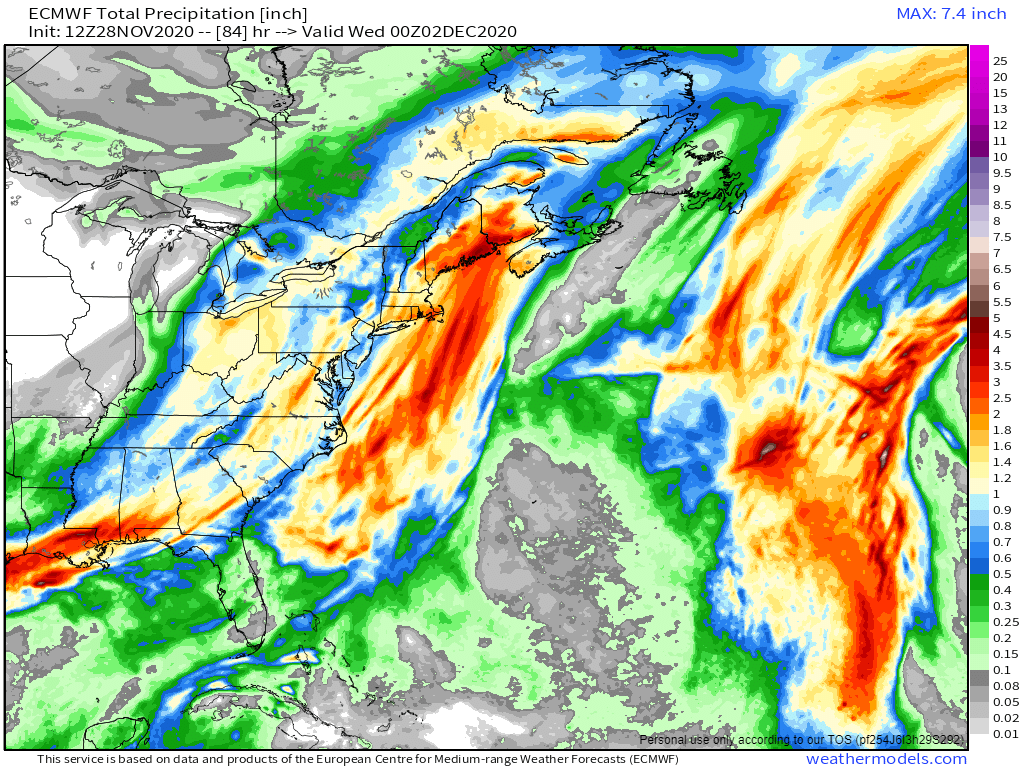
In addition to the warm weather, heavy rain is likely for much of the East. The warm, moist air being drawn northward from the Gulf of Mexico will be deposited up and down the East Coast later Sunday into Monday, and early Tuesday for parts of New England. Rainfall totals of 1-2 inches will be common, with some places possibly picking up 3 inches or more, especially in parts of eastern New England. While this will help put another significant dent in the long term drought that the region is experiencing, too much rain at once will likely lead to flooding in some areas.
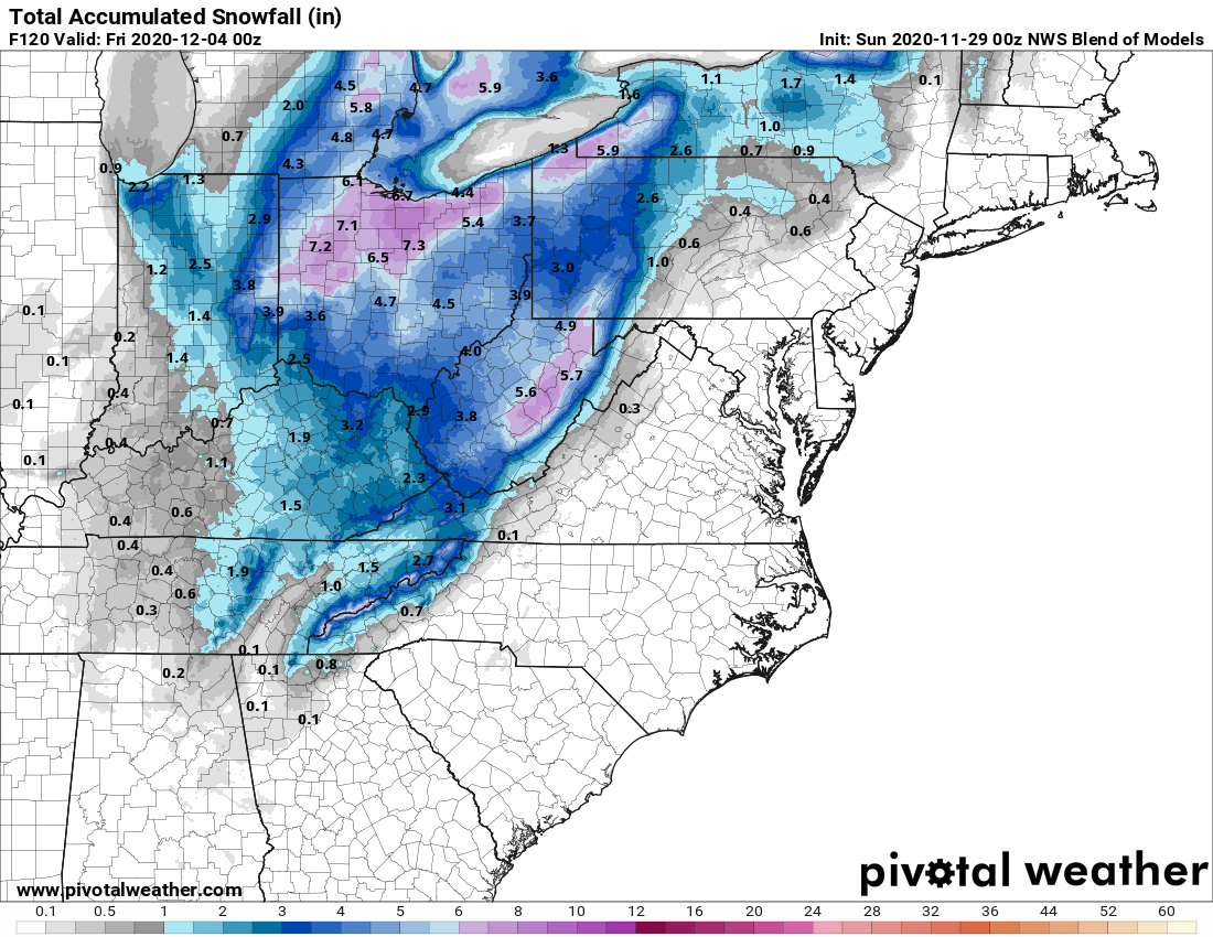
While all of this is going on ahead of the storm, a different scenario will be evolving on the storm’s back side. Colder air flowing southward from Canada will clash with the warm air, resulting in snow across parts of the Great Lakes and the Appalachians. The snow will be accompanied by gusty winds, lowering visibility in many locations, resulting in very hazardous driving conditions. While the snow won’t be exceptionally heavy, many places could receive upwards of 4-8 inches by the time everything winds down. Across the higher elevations of the Appalachians, even into the southern Appalachians, some heavier amounts are possible as well. As the systems gets caught under an upper-level low pressure system in southeastern Canada, it may produce some lake-effect snow into mid-week downwind of Lakes Erie and Ontario.
Once this system pulls away, things will quiet down across the East for a few days, but there are signs that another system could impact parts of the East next weekend.