Snow Continues in the Great Lakes

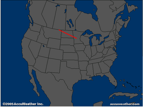
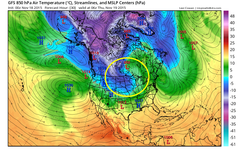
It has been interesting to watch the development of the low pressure system over the Midwest toward the end of the past workweek and into this weekend. Basically what happened with this storm was that an energetic disturbance was able to dive south out of Canada and create a setup conducive for storm intensification just east of the Rockies.


A low pressure system exits East Asia.
A low pressure system exits East Asia. Note the direction of flow into the Pacific Northwest.
The low pressure system from Eastern Asia moves into Alaska.
The low pressure system from Eastern Asia moves into Alaska. Note the slight northwest flow in Western Canada.
High pressure develops south of Alaska.
High pressure develops south of Alaska. Note the north-northwest orientation of the flow in Western Canada.

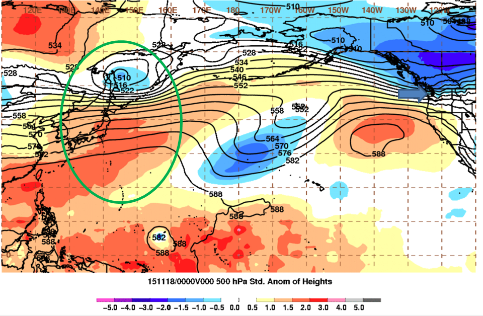
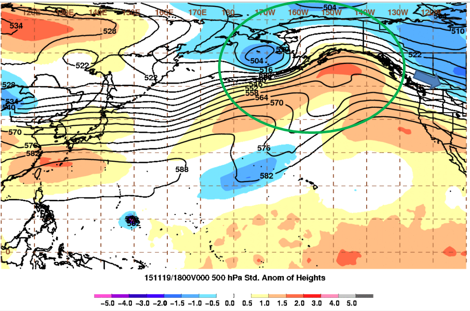
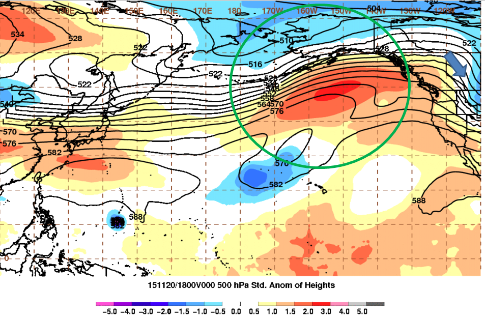
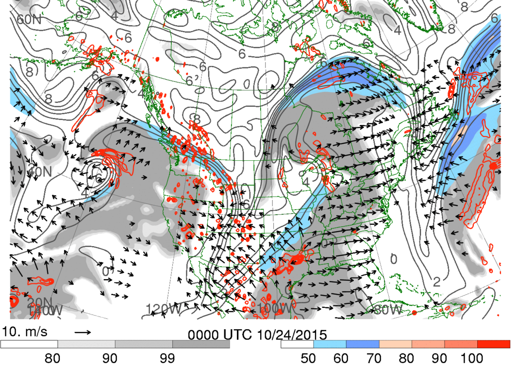
But it all started out back in East Asia as an area of low pressure exited there with a strong area of high pressure just south of it. It then moved toward Western Alaska, still with the high pressure area just to its south. Then the high pressure area was able to intensify just south of Alaska and this was able to help change the previously horizontal flow in the Eastern Pacific to become wavier or meridional, which helps storm development. This is indicated in an index called the Eastern Pacific Oscillation that basically identifies the high or low pressure departures from normal with a negative index meaning a high pressure area near Alaska and a low pressure area for a positive index. This index dropped from very positive to slightly negative indicating a change to a higher pressure in that area and a more meridional flow. As a result, a stronger northwest jet developed in Western Canada helping the energetic disturbance dive further south from Canada to just east of the Rockies.


Another part of the equation was getting the cold air into the Northern Plains in the first place and developing an area for the storm to develop at all. This was a put together as the low pressure system that developed starting last Monday and intensified through Thursday sent cold air rushing into the Plains allowing the energetic disturbance from before to dive south in already colder air.

Area encircled by yellow shows the colder (cool colors) flowing into the Northern Plains from Canada on the back end of the low pressure system in Central Canada.
Area encircled by yellow shows the colder air (cool colors) flowing into the Northern Plains from Canada on the back end of a low pressure system in Central Canada’s cold front.


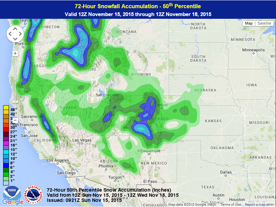
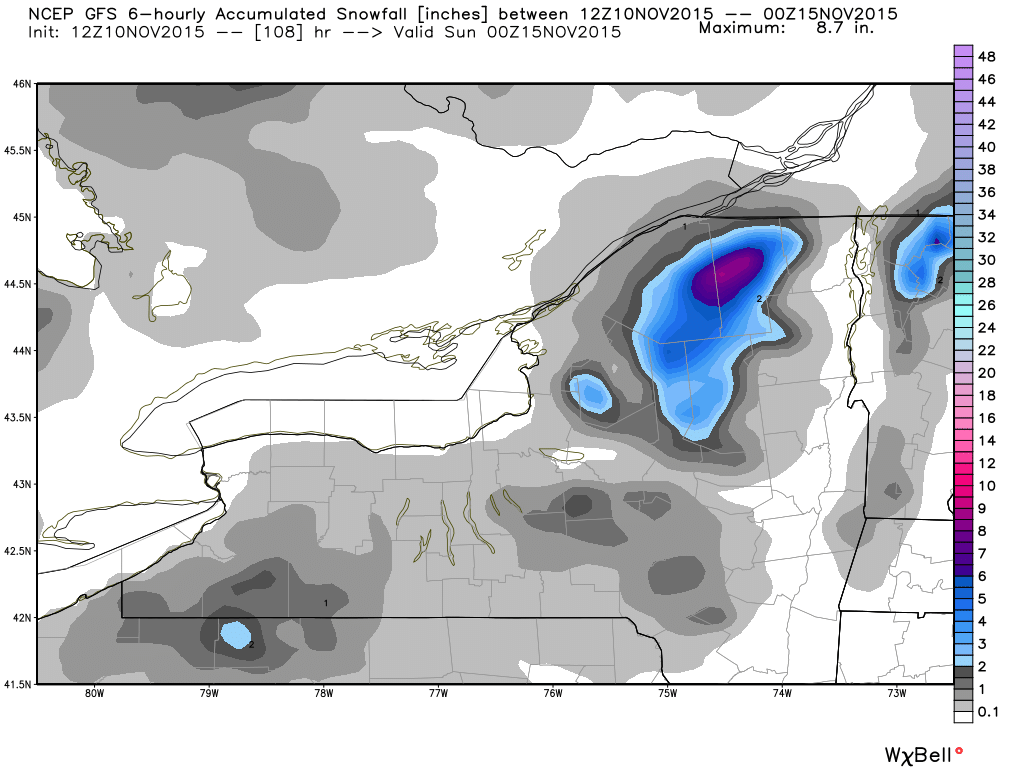
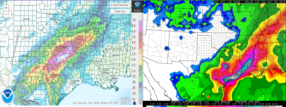
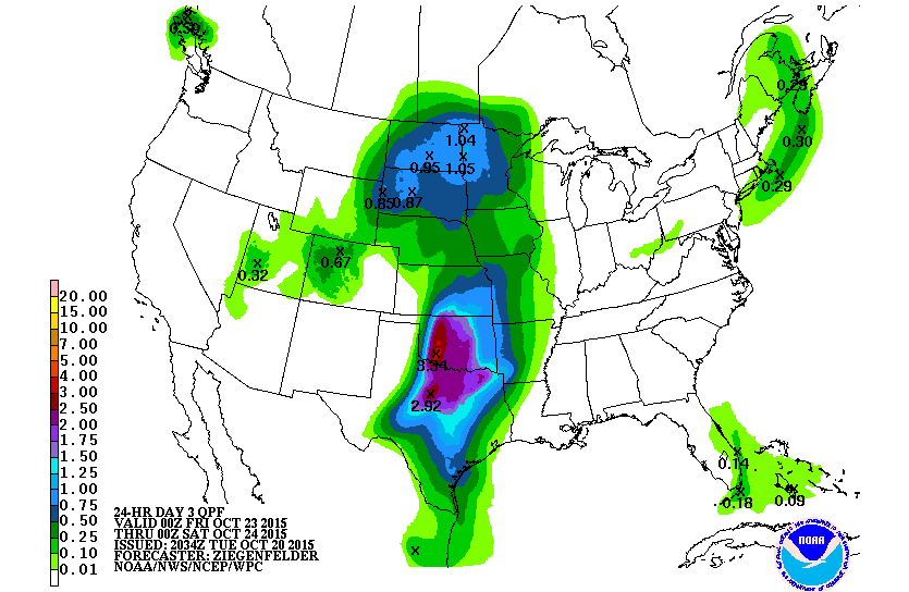
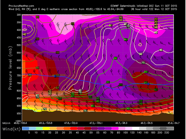
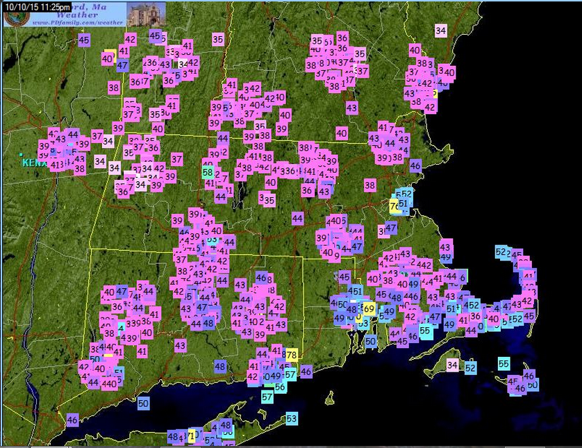
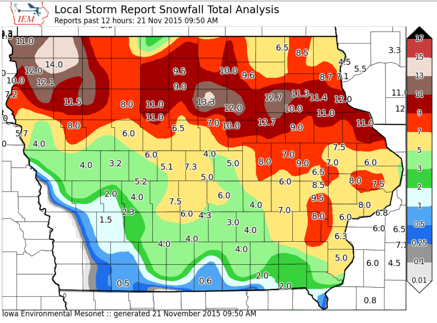
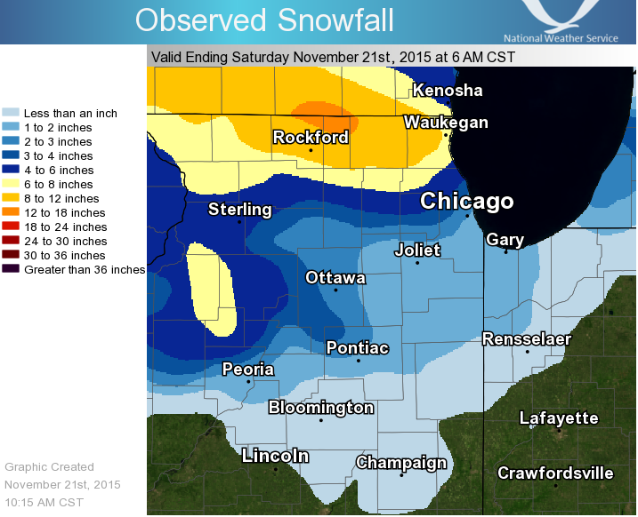
This storm is the first snow storm of the winte, dropping plenty of snow from Iowa into the Great Lakes. As of Saturday morning, some areas saw over a foot of snow with snow continuing in Illinois and moving into Michigan. As the storm continues to move into Michigan, it will develop a negative tilt, which allows it to grab warm, moist air and, within cold air, turn it into snow easier. Snow accumulations are forecast to total 5 to 10 inches, but there could be more than that where the instability is the strongest and if it resides in one area for longer periods of time.  Furthermore, where the winds are blowing in from the right direction, additional snow could be had as lake effect snow forms, especially as the ground surface is able to warm after the storm and cooling winds stay around.

Snow totals in Iowa up to Saturday morning.
Snow totals in Northern Illinois up to Saturday morning.


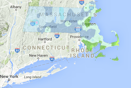
In addition to the snow, strong winds are also forecast along and near the Great Lakes where the water allows for less friction and strong winds. For example, in Western New York, winds will be from 20 to 40 miles per hour and may gust to 50 or 60 miles per hour from this evening into the overnight. With winds this strong, power outages cannot be ruled out.

Another Round of Severe Weather for the Nation’s Midsection

In a similar setup to last week, a cold front dropping south from the Pacific Northwest to the Southwestern United States signifies the upper level jet from the polar regions dropping south. At the same time, another upper level jet resides in the subtropics. These two will combine or phase and create enough energy to develop a low pressure system just east of the Rockies. As the storm gets going it will be able to wrap in cooler air especially on its western side and snow will be able to develop in the Southern Rockies. A general 1 to 4 inches are possible from Nevada to Western Nebraska and Kansas with higher amounts possible in the higher elevations. Wind gusts should be around 45 mph, but could be as high as 65 mph along in the higher terrain.


Snowfall forecast through early Wednesday. (Note this isn't quite the mean, but it is the 50th percentile). Via WPC.
Snowfall forecast through early Wednesday. (Note this isn’t quite the mean, but there are equal chances that the final outcome is larger or smaller than this total.) Via WPC.


Meanwhile, on the eastern side of the low pressure system, warm and moist flow will be able to create enough instability and very strong wind energy and low level moisture should be available for thunderstorm development. On Monday, the area with the greatest threat is within the Southern Plains. The day’s storm mode will probably include supercells, but should eventually evolve into a squall line type as the night overtakes the day. Tornadoes along with strong winds will be very possible with a few areas of hail with the day’s storms and very strong winds and heavy rain will be possible with the nighttime squall line as the earlier discussed phased jets allow for strong winds that can get brought to the surface in the intense vertical motion within rainfall and thunderstorms. For Tuesday, the area with the strongest storms shifts east as the low pressure system moves northeast and its attendant cold front slowly moves east. The cold front will be the main driver of the thunderstorms for this time period and while the squall line will be the main story for Tuesday, some supercells ahead of the cold front can’t be ruled out.


Severe weather outlook for Monday via SPC.
Severe outlook for Tuesday via SPC.
Monday helicity (top) and shear (bottom) forecast. 200 m2/s2 of helicity is enough for tornadoes. 30 kts of shear is enough for tornadoes.
Monday shear (top) and helicity (bottom) forecast. 200 m2/s2 of helicity is enough for tornadoes. 30 kts of shear is enough for tornadoes.

In addition to the severe weather and snow, rain is also possible near the low pressure system and both the warm front and cold front during this time period, especially in any thunderstorms. Because of the way the combined jet stream is situated and the added energy of the phased jet streams, the heavy rain will be situated in the lower Plains and lower Mississippi Valley regions. Over 5 inches is forecasted especially in the lower Mississippi Valley region, but that rainfall total could be higher in any thunderstorm.  Furthermore, previous consistent rainfall over northeast Texas allowed rivers within the headwater basins of the Neches and Sabine Rivers to remain swollen so the National Weather Service and River Forecast Center in the Northeast Texas area have indicated that those rivers in that basin could flood during this upcoming event.

Areas to watch for flooding during upcoming rain storm. Via the West Gulf River Forecast Center.

Strong Storm May Produce Severe Weather, Blizzard Conditions, and Lake-Effect Snow

A strong storm system moving out of the West will bring heavy snow to the Rockies, severe weather to the Mississippi Valley, and maybe even some lake-effect snow to parts of the Great Lakes before the week is over.

A developing low pressure area will move across the Rockies and into the Central Plains today. Over the weekend this storm brought beneficial rainfall to California, with snowfall across the higher elevations of the Cascades and Sierra Nevada. Up to an inch of rainfall fell across the San Francisco Bay area, with locally heavier amounts of 1-2 inches in Santa Clara and Santa Cruz Counties. Farther inland, 1-2 inches of rain was reported across much of the Central Valley. Strong thunderstorms were also reported across the area, with a tornado warning issued Monday evening for the suburbs of Sacramento, though no tornado was ever confirmed to have touched down.  In the Sierra Nevada, as much as 6-12 inches of snow was reported as of Tuesday morning. At the National Weather Service office in Reno, Nevada, four inches was reported in one hour Monday evening.

As the system moves eastward, snow is expected across much of the Intermountain West today into Wednesday. The heaviest snow is expected across the mountains of Utah and Colorado, where 8-16 inches may accumulate. Rain will change over to snow across the western Plains as colder air filters in behind the system. Snowfall totals of 3-5 inches are expected across western portions of Nebraska and Kansas as well as eastern Colorado, including the Denver Metropolitan Area. The snow will be accompanied by northerly winds of 20-40 mph, gusting to 60 mph at times. As a result, blizzard warnings are in effect for much of this region, with high wind warnings for much of the remainder of the Central and Southern Plains.

Watches and Warnings in effect for the Central US as of Midday Tuesday November 10.
Watches and Warnings in effect for the Central US as of Midday Tuesday November 10. Blizzard Warnings are in Red, Winter Storm Warnings are in Pink, Winter Storm Watches in Dark Blue, Winter Weather Advisories are in Purple, High Wind Warnings are in Light Brown, and High Wind Watches in Dark Brown.

Southerly winds ahead of the storm will continue to draw warm, moist air northward from the Gulf of Mexico. With the clash of airmasses, strong to severe thunderstorms will likely develop ahead of the cold front on Wednesday from northeastern Texas into much of the Mississippi Valley. Strong winds, hail, and tornadoes are the main threats with any storms that do develop. The best chance for tornadoes looks to be across portions of Iowa, Illinois, and Missouri, where a few strong tornadoes are possible.  Just to the north of this area, heavy rain is likely from eastern Nebraska and northern Iowa into southern Minnesota and much of Wisconsin. Rainfall totals of 1-2 inches are possible across this area.

Severe Weather Outlook for Wednesday November 11 from the Storm Prediction Center.

By Thursday, the storm will move into southern Canada, dragging a cold front across the East. This will produce showers across much of the Northeast and Mid-Atlantic states, with gusty westerly winds ushering in cooler air behind the front. As these westerly winds blow over the relatively warmer Great Lakes, some lake-effect rain or snow showers will likely develop on Friday and Saturday. Some snowfall accumulation is possible, mainly over the Tug Hill Plateau of northern New York and parts of the Southern Tier in western New York. A few inches of accumulation are possible, with heavier amounts in the normally favored locations.

Snowfall forecast for Friday and Saturday from the GFS model. Image courtest of WeatherBell.
Snowfall forecast for Friday and Saturday (November 13-14) from the GFS model. Image courtest of WeatherBell.

Another Strong Storm for the Midwest This Week?

Another cold front will move into the West Coast on Saturday allowing for some showers in the Pacific Northwest during the day and then will move south overnight providing showers to California and other portions of the Western United States. The highest rainfall totals over the next 3 days will be along the coastal regions, but total projections look to be with the 1 to 3 inch range. Some snow showers are possible especially overnight and in the higher elevations of the Rockies as the front moves ashore. Many higher elevations should see 1 to 3 inches with a possibility of more through early Tuesday morning. Once again, this is good news for drought-stricken regions that are nearby mountainous regions, which can accumulate snow, so that when warmer weather comes back and allows for melting, it will create more drinking water and some of the runoff may go back into the water table and begin to replenish some lakes and streams.


Rainfall over the next 3 days.


Projection of snowfall where there is equal chances of being over this amount and being below this amount. It's close to being the mean.
Projection of snowfall where there is equal chances of being over this amount and being below this amount. It’s close to being the mean.


It is interesting to watch the model projections for energy associated with this cold front in the future. The southern jet stream, known as the subtropical jet, has gotten going over the last week along the border of the Gulf States with the Gulf Coast, so as this cold front dives south along the northern jet stream these two jet streams will combine, which is known as phasing. Often when upper level jet streams phase, a strong low pressure system can develop with the increased wind aloft helping it to intensify or cycle. This occurs with the low pressure system that is projected to develop just east of the Rockies early Wednesday through Friday.


A cold front enters the Pacific Northwest. Then a low pressure system develops. Via the College of DuPage.


Model projection of the infrared satellite image as the low pressure grows over the United States
Model projection of the infrared satellite image as the low pressure grows over the United States. Via Tropical Tidbits and Levi Cowan.


Winds rotate counter-clockwise around low pressure systems which allows for cool northerly winds to come into the United States. Sometimes the cooler temperatures can mix with more moist air and create snowfall over lower elevations especially at night when cooler temperatures can also result. This is what may happen on the west side of this system mid to late week next week in the Northern Plains. It is still too early to show model projections, but any accumulation looks to be light in the lower elevations.


Tropical Development over the next 5 days.

In addition to the active weather coming up over the United States, the tropics have gotten active again. This is especially true in the Atlantic, where two areas are being watched over the next 5 days for tropical development. The first is in the western Gulf of Mexico, which has a low probability of development over the next few days. A low pressure system around 300 miles southeast of Brownsville, Texas resides there and thunderstorms have become more concentrated near this low. During the day today, a cold front will come near it and the area of storms will merge with it. The other area of storms has a better chance of development. It is a large area of showers in an area from the northeastern Caribbean Sea through the Lesser Antilles and into the Atlantic. Some gradual development of this disturbance is possible by early next week, but regardless, heavy rains are possible over the Lesser Antilles, the Virgin Islands, Puerto Rico and Hispaniola over the next few days. Any development of this system will be slow over the next few days.

Another Round of Flooding in Texas

Another batch of heavy, flooding rain occurred in Texas on Friday as strong low level winds flowed in from the south. Those winds combined with moisture that were both above normal for that region helped to aide in the development of strong showers over the region. Furthermore, a strong upper level jet was centered in the right place, over Texas, for strong large scale lift signified by strong upper level divergence. At one point, up to 10 inches of rainfall occurred in 2 hours in an area south of Austin, Texas. Many roads and bodies of water flooded with plenty of rainfall in a short period of time.

Tweet from Matt Lanza showing the location of a 10+ inch rainfall report in 2 hours.


With all of this rainfall, one would have to assume that the drought would at least be alleviated somewhat, but unfortunately there is still drought to be contended with in the Texas. Even still, in one week, the rainfall has lessened some of the drought with some areas reaching as high as 5 classes of drought improvement in eastern Texas. Since October 20, Texas has seen as much as 20 percent of the state added to the no drought category in the drought monitor. At the same time, Texas now has none of its area in the highest 2 categories of the drought monitor. Even the areas with a class 2 drought have dropped into single digits for a percentage of the state. It still appears that around 28 percent of Texas is in a class 1 drought according to the drought monitor.


Drought change up to 5 classes in some areas of eastern TX during the past week. Via the Drought Monitor.


Also, strong shear near a warm front in the area combined with the already moist environment, allowed for numerous tornadoes within storms that formed inland as opposed to staying near the coast like last week’s event. Because of the strength of the severe event, a tornado watch that lasted the entire day and a severe thunderstorm watch for western Texas were issued by the Storm Prediction Center. The severe thunderstorm watch for western Texas was for the southern portion of a strong squall line that formed a bow like feature in it signifying strong straight-line winds in that region.

Warnings (polygons) and reports (squares) during the severe weather and flooding event to end the work week and finish Saturday.


This area of low pressure will then move east northeast as the upper level trough that helps to create the forcing for the area of low pressure moves in that direction. During that time, it will leave a swath of 2 to 6+ inches of rainfall from Louisiana to southern Virginia. On Saturday, the low pressure system will continue to deepen, becoming a cold-cored upper level low pressure system and will have its winds, shear and instability die down along its east-northeast path as it moves more inland than it was Friday and Saturday.

Chapala's track and warning cone over the next few days.
Chapala’s track and warning cone over the next few days.


While the tropics in the Atlantic and Pacific remain quiet, the Indian Ocean is active. A storm named Chapala is located 475 miles south-southwest of Masira Island near Yemen and is moving west at around 8 mph. Chapala has an 4.5 mile diameter pinhole eye and appears unaffected by nearby wind shear. Being steered by a ridge of high pressure just to its north, Chapala will make landfall over central Yemen as it tracks northwestward. It will then weaken as dry air and shear erode the system and interaction with land tears it apart.

Rain continues in the Southern Plains

As much as 10 or more inches of rain fell south of Dallas, Texas on Friday,  resulting in widespread flooding. This occurred as moisture was able to be pulled inland from the Gulf of Mexico along a low level jet that had a strength that was at times 2 to 3 standard deviations above normal. Also, surface moist convergence resided within an area that contained plentiful amounts of moisture in the form of precipitable water that was 2 to 3 standard deviations above normal. This all took place over the same area for most of the day. Additionally a cold front approached from the north and thunderstorm chances rose to the north of the area of convergence. As that cold front approached from the north, upper level divergence occurred in the right entrance region of the upper level jet allowing for large-scale upward motion. Consequently many cells were able to back-build and resided in the same place for long periods of time allowing for an over-saturation of the ground in those places and standing water for flooding.


Notice where all the large scale lift is centered. Red area in large scale lift, with blue and red fill being jet strength and vectors are irrotational wind.
Notice where all the large scale lift is centered. Red circled area is large scale lift, with blue and red fill being upper level jet strength and vectors are irrotational wind. As of 10/23 at 7PM central.


A few ingredients of the previous flooding via WPC.


Moving forward, model projections have plenty more flooding moisture coming into the Southern Plains, but it should remain further south this time. Major Hurricane Patricia, which rapidly weakened, but was above Hurricane status just before reaching landfall in Mexico, will have an effect on the Southern Plains. Patricia’s remnants will get drawn into the aforementioned jet stream and will add moisture to the rainfall along the southern shores of Texas. The upper level jet and its dynamics move away from the region, so the bulk of the precipitation will now be a result of the remnant low pressure system from Patricia. Precipitable waters will be up to 3 to 4 standard deviations above normal, which is higher than what was in North Texas. But, while the storm should have heavier rainfall rates with strong low level winds bringing more moisture in from the Gulf, a short time for precipitation occurrence will happen as the low pressure system moves away quicker than the stalled out boundary in North Texas. A severe weather threat also exists with increased shear paired with the strong moisture content. Generally, tornadoes occur in the right front quadrant of a low pressure system depending on the direction of movement because that is where the apex of the low level jet tends to be. So, a northward movement would allow tornadoes to occur in the northeast side of the low pressure system. The strong rain should be out of Texas by Monday morning. As the storm continues along, it will continue losing tropical characteristics and will move to the northeast and affect regions from the Gulf-bordering States to the Northeast through the middle of next week as the energy and moisture from Patricia combines with another trough to the north and swings to the north and east.


Past precipitation accumulation and upcoming forecasted precipitation.
Past precipitation accumulation and upcoming forecasted (GFS) precipitation.

Speaking of previous tropical cyclone Patricia, there are only two named storms, including Patricia, from the Central Pacific to the Atlantic Ocean. As of late Saturday afternoon the remnants of Patricia were located about 45 miles southwest of Monterrey, Mexico. A low pressure system over southern Texas is also developing, but is expected to be non-tropical even with the remnants of Patricia being absorbed into it. The main threats continue to flooding and mud slides in Mexico and flooding and severe weather in Texas.

Flooding Possible in the Plains, Another Tropical System in the Pacific

An upper level low pressure system will slowly move into the Southwest over the next few days. Between Thursday through Saturday, plenty of moisture will be streaming in from the south, resulting in 2 to 3 inches of rain falling in portions of the Great Plains. Mechanisms helping this along include the strong low level jet from the south with an intensity that is 2 to 4 standard deviations above normal at times. Favorable upper level jet dynamics, in the form of the right rear quadrant of the upper level jet, will be above the region, allowing for strong large scale lift. Moisture in the atmosphere, in the form of precipitable water, will also be 2 to 4 standard deviations above normal. The one important part of the movement of this system is the fact that the low pressure system gets picked up by a trough to the northwest and directed north, meaning that the main forcing gets directed north while the bulk of the moisture stays south. At the same time, however, the precipitation is directed into the same area in northeastern Texas Thursday night to Sunday morning as a cold front runs into a surface trough. All in all, while severe storms are possible with this setup, flooding seems the most problematic outcome with a continuous flow of moisture paired with dry hard-packed soil that will suck up little rainfall in portions of the Southern Great Plains. The rain should shutoff early Sunday as a ridge of high pressure enters. The ridge of high pressure lasts until Tuesday, when another cold front comes in.


Thursday through Friday rainfall forecast.


Meanwhile, in the Tropics, the Atlantic remains quiet. However, in the Eastern Pacific, Tropical Depression Twenty-E is centered about 235 miles southeast of Puerto Escondido, Mexico as of Tuesday evening. This low pressure system will be directed to the west-southwest by a mid-level ridge just to its north, over the Gulf of Mexico. The ridge is forecast to move eastward so the low pressure system is then steered to the north between an approaching front to the west and the high pressure ridge to its east. Guidance also seems to be in agreement that a landfall in western Mexico should occur around Saturday as a hurricane. An increasing intensity has been indicated by the previous text in this paragraph and this fits with the large scale environment being conducive for development. The main contributors are very warm sea surface temperatures and light shear adjacent to the storm. Even still, two areas with negative impacts on the storm are possible with dry air entrainment into the storm from strong winds through the Isthmus of Tehuantepec and an uncertain inner core strength. If the inner core does get strong enough, dry air entrainment will become less of a problem. It is thought that the positive factors will outweigh the negative factors so intensification is forecast with the storm becoming a Tropical Storm between now and early Wednesday. In the Central Pacific, Hurricane Olaf is located 1060 miles east-southeast of Hilo, Hawaii and 1275 miles east-southeast of Honolulu Hawaii. Hurricane Olaf does have 15 nautical-mile wide eye and a concentric ring of convection. A recurving track is forecast for Olaf as it moves around a ridge of high pressure to its north. Then a disturbance picks up Olaf and brings it northeast. This track keeps the bulk of the hurricane’s main impacts away from the Islands, but a strong swell is still possible this weekend. Shear is expected to remain weak until later Wednesday and the system does move over warm sea surface temperatures so strengthening is possible in the near term. Next, shear is expected to increase water temperatures are expected to decrease so weakening is possible starting Friday.

Hurricane Olaf's forecast track
Hurricane Olaf’s forecast track


Cold in the Northeast, Wet in the West, and Active in thePacific

The US is littered with all sorts of weather for this weekend. The most hazardous weather has already been addressed in a previous blog post entitled, “Much Colder Air Headed for the Great Lakes and Northeast” and is all about the cooler temperatures and, combined with the scattered precipitation across the Northeast, snow; especially in the northern and western areas of the Northeast and higher elevations. A warm up is expected after the cooler air aloft moves offshore and warmer air moves in beginning this coming Tuesday.


Recent drought observations and weekly change.


Furthermore, a cold front moves onshore in the Western United States bringing showers and inland thunderstorms to an area that has been very dry this summer and has had numerous wildfires sprout. Between Saturday and Tuesday, a 3-day rainfall total of up to 3 inches is expected in portions of the Rockies with under an inch possible in other lower elevations. Still, southwestern California may remain dry as plenty of dry air remains around the region and may allow for evaporation before the rain reaches the ground. Some flash flooding is possible in the Southwest as the warm, moist flow continues to enhance showers and storms.  Some drought relief is possible this winter as a strong El Nino is developing. On average, California receives plenty of precipitation during El Nino events, so a dent may be made in its drought situation. In the 1997 strong El Nino, California received plenty of rain, but it was spread out over a long time period, which is the best case scenario, because it means less flood problems as opposed to when it comes all at once with ground that dry and stiff. A few quick events can help to moisten and open up the ground for future event and allow for some absorption of the water into the ground. With many of the smaller events, snow can still accumulate in the higher elevations, which helps the drinking water problem because of melt-water runoff once the winter is over. Of course not every El Nino is the same so it’ll be worth watching this winter.


3 -day precipitation totals.
3 -day precipitation totals via WPC.


Over the oceans, the Atlantic remains quiet with only one area that could develop tropical characteristics. Even still the chance that that happens is low. It is near the Yucatan Peninsula and is associated with an area of low pressure nearby. Its proximity to land is not helping its development chances at all during the next day or so. Some tropical development is possible as it crosses back over onto water late this weekend or Monday. Even without tropical development, heavy rain is expected over Central America from the system. In the Eastern Pacific, Tropical Storm Olaf resides 1660 miles west-southwest of the southern tip of the Baja Peninsula. It has been affected by an area of high pressure, but that is set to weaken, which should allow a gradually slowing of speed and move more northward. Pressure centers and resultant stream flow allow for a continuation of a northward movement of Olaf especially by Tuesday, though gradually increasing northward movement is also possible starting today. In terms of intensity, shear currently around the storm is affecting it, but it isn’t understood how much. It’s thought that the shear is slowing the intensification so with shear expected to diminish by around Monday, intensification should occur to a major hurricane in the early work week. Another area of showers and storms needs to be watch especially by 5 days out or midweek next week for tropical development into a tropical depression as it moves westward away from the Americas. Further development of this system is likely.

Current tropical activity with Tropical Storm Olaf and the area to watch near Central America.

Much Colder Air Headed for the Great Lakes and Northeast

After a relatively warm summer and early autumn, some of the coldest air so far this season will sweep southward from Canada over the next several days.

A cold front will drop southward across the Plains and the Great Lakes on Thursday with a large high pressure area building in southward behind it. Scattered showers are expected ahead of the front, but they will be mainly light. The bigger story will be gusty northwest winds behind the front ushering the cooler air into the region. Frost Advisories and Freeze Watches have already been posted for Friday morning across portions of Nebraska, Kansas, and eastern Colorado, and more will likely be issued.

As the front marches eastward Thursday night and Friday showers will spread into the Northeast while the cold air pours into the Midwest. Rain could mix with some wet snow before ending across portions of northern Minnesota and the Upper Peninsula of Michigan. As high pressure builds in, skies will clear out across parts of the area and winds will diminish, allowing temperatures to drop into 20s and 30s across much of the Midwest. While a frost or freeze has occurred across northern parts of the region already, in southern areas, this will lead to an end of the growing season.

Low temperature forecast for Saturday morning.

By Friday night the front will push offshore, but an upper-level low pressure area will settle into the region. This will likely trigger additional showers across parts of the Eastern Great Lakes and northern New England. Most of these will be light once again, but with colder air settling in, some wet snow could mix in, especially in the higher elevations of northern New England. Little, if any, accumulation is expected, except at the higher peaks. With the upper-level system nearby, Saturday will be a breezy and cool day across much of the region under partly sunny skies. As this system moves into southeastern Canada, high pressure will build into the Great Lakes, allowing skies to clear out. This may result in frost and/or freezing conditions across most of the Ohio Valley, the Appalachians, and interior Northeast, ending the growing season across much of the region.

Low temperature forecast for Sunday morning.

By Sunday, high pressure slides eastward, allowing for a sunny but cool day across most of the Northeast. The exception will be across northern New England. With the upper-level low still nearby, rain and snow showers will continue across the higher elevations of Vermont and New Hampshire, as well as much of northern and western Maine. Accumulation of 1 to 3 inches are expected, with some heavier amounts possible in extreme northern Maine. Skies should become clear across most of the region Sunday night, and with diminishing winds, temperatures will drop quickly at night. A widespread frost and/or freeze is expected across much of New England, mainly away from the coastal plain. Temperatures may only drop into the middle 30s in the urban areas, but most of the suburbs will likely drop into the 20s to lower 30s by Monday morning.

Low temperature forecast for Monday morning.

As the high slides offshore, southwest to west winds will allow warmer air to move back in, with high temperatures bouncing back into the 60s and lower 70s by the middle of next week.

Strong Winds in the Northern Plains

A low pressure system will move through the Northern Plains this weekend and into Monday with strong gusty winds. Sustained winds strong as 30 to 40 mph with gusts up to 50 mph  or more are possible into Monday in places such as Jamestown, North Dakota. One other factor that could help to exacerbate this even further is the fact that some areas, especially to the north, may see some rain from the low pressure system. Often winds get briefly stronger in rain as even stronger winds aloft would get brought down to the surface. Winds should die down in the Northern Plains late Monday into Monday night as the low pressure system and attendant cold front leaves the area.


Place in the Northern Plains where cross section was taken


Strong winds (colorations) come down close to the surface. Green lines indicates the atmosphere is moist for a chance of rain.
Strong winds (colorations) come down close to the surface. Green lines indicates the atmosphere is moist for a chance of rain. (Image courtesy of AccuWeather.com)


It was a chilly weekend across the Northeast as Frost Advisories were issued over Southern New England Saturday night as dry air poured into the region behind Friday’s cold front. With the cold and dry air in place, radiational cooling allowed low to drop into 30s in many areas. Radiation cooling occurs where warmer air can escape readily into the upper atmosphere and cool more completely than if there were clouds around. Of course the urban heat island effect, elevation, proximity to warmer land masses like the ocean and soil type play a huge role helping to regulate how cold temperatures get.  For eastern areas of Massachusetts and eastern areas of New York, that recorded frost, this is right around the normal date for their first frost, which is around October 11-20. Western Massachusetts areas are only a day or two late with their first frost normally from October 1-10. Overall though, it is well on target with the average first frost. Temperatures should be on a warming trend ahead of Tuesday’s cold front.

First frost date in New York
First frost date in Massachusetts


Temperatures as of 11:30 PM Saturday night that warranted the Frost Advisories.


In the tropics, the Atlantic region does not have any areas that are being monitored for tropical development, but the Pacific Ocean has Tropical Storm Nora. It crossed from the Eastern Pacific into the Central Pacific Saturday evening. Nora currently has maximum sustained winds around 65 mph. Satellite images showed a developing eye wall aloft. In the early part of its forecast, as it continues its westerly track, shear will remain low and warm waters around the storm will allow for further strengthening. By Tuesday, the westward trek of the storm will be changed to more northerly as a high pressure system to the north begins to break down and an area of low pressure approaches from the west. The northerly track would start to occur well east of the Hawaiian Islands. As Nora begins its turn north on Tuesday, an area of low pressure will also allow vertical shear to increase so a decrease in strength may occur after Monday and along its northerly track. The other area being monitored is currently centered about 600 miles south of Acapulco, Mexico. Environmental conditions are expected to be conducive for slow development and a tropical depression is likely to form late this week as it continues along its westward track.

Back to top