The tropics remain quiet in the Atlantic right now, but it’s a different story in the Pacific, where there are currently six active systems, three in the East, and three in the West.
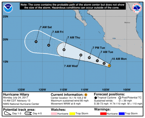
Starting with the Eastern Pacific, Hurricane Hilary is the strongest on the storms as well as the closest to land. At midday Monday, Hillary was centered about 340 miles south of Manzanillo, Mexico, moving towards the west-northwest at 8pm. This track is expected to continue for the next few days, bringing the system away from Mexico. Hilary has maximum sustained winds near 80 mph, but it is in an environment favorable for strengthening, and is expected to become a major hurricane over the next 24-36 hours. After that, a gradual weakening trend is expected.
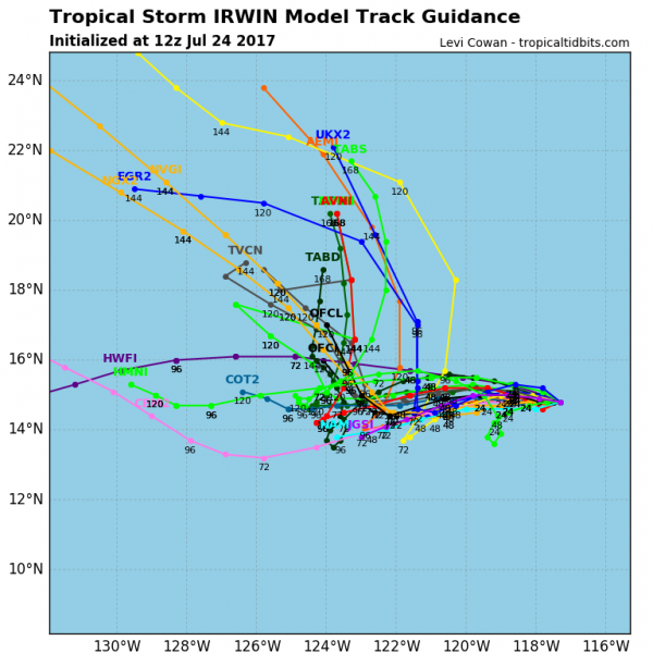
A little farther to the west is Tropical Storm Irwin. Irwin was centered about 750 miles southwest of Cabo San Lucas, Mexico at midday Monday, drifting westward at 3 mph. Irwin has maximum sustained winds of 60 mph, and additional strengthening is expected. Irwin should become a hurricane Monday night or Tuesday. The forecast track for Irwin is highly uncertain at the moment. Several of the computer models show an erratic motion for the storm, as it may interact with Hurricane Hilary. Irwin will remain over open water for the next several days, and is not a threat to any land areas.
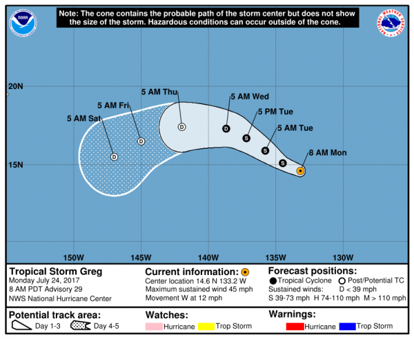
Heading westward again, we come to Tropical Storm Greg. Greg’s top winds peaked at 60 mph on Friday, and has been slowly weakening over the weekend. At midday Monday, Greg had top winds near 45 mph, and additional weakening is expected over the next few days. Greg was centered a little more than 1500 miles east of Hawaii, and was moving towards the west at 12 mph. Greg should dissipate well east of Hawaii later this week.
In the Central Pacific, there are no active storms at the moment. However, what’s left of Hurricane Fernanda is moving across Hawaii today, producing some gusty winds along with locally heavy showers and thunderstorms on Oahu and Kauai. At one point last week, Fernanda was a Category 4 hurricane with top winds of 145 mph over the open waters of the Eastern Pacific.
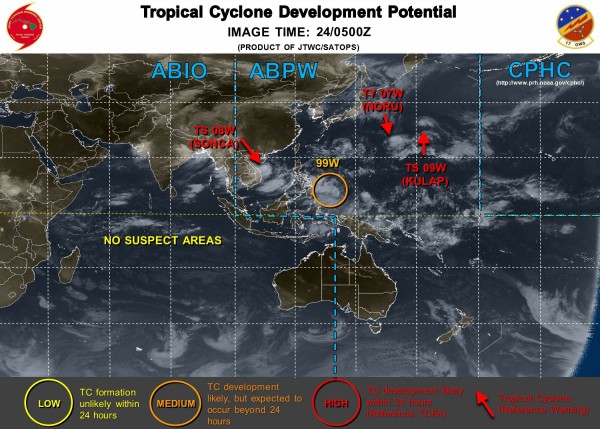
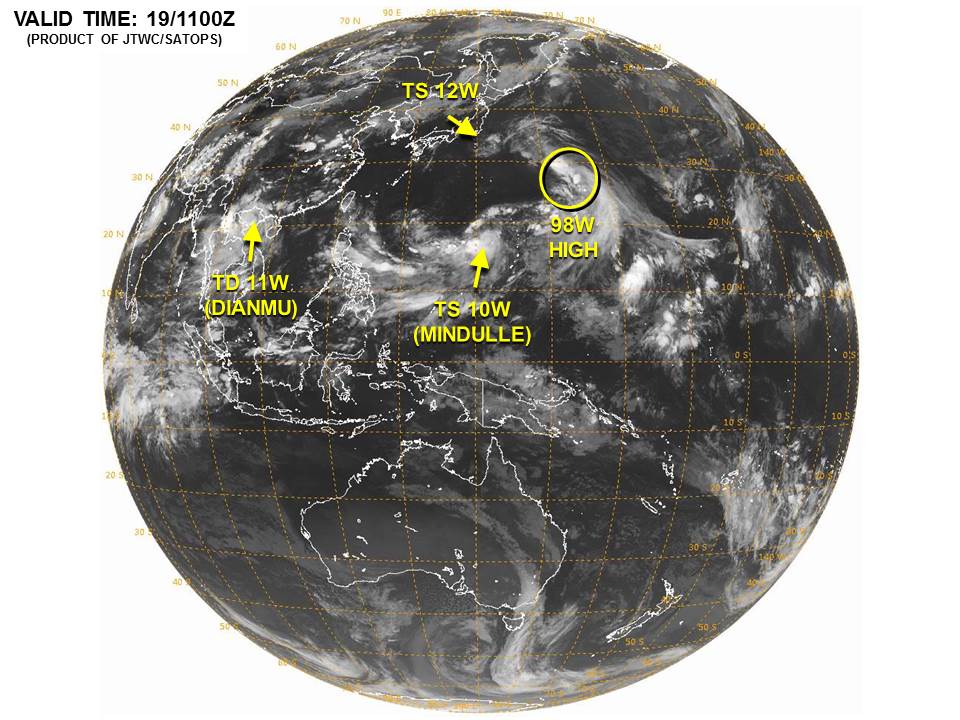
In the Western Pacific, we also have three active systems, and another area being watched for development.
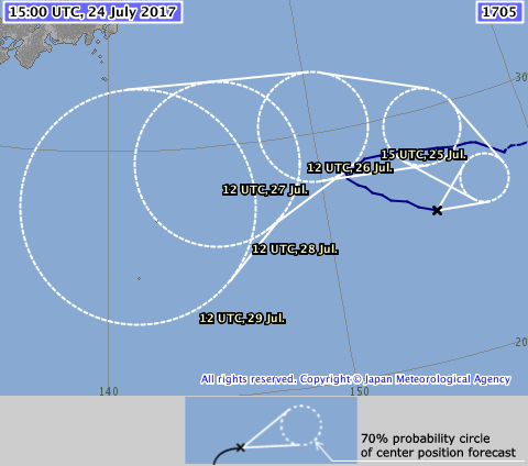
The strongest of the storms is Typhoon Noru (07W). Noru has been meandering around in the waters well southeast of Japan for several days, and this erratic motion should continue for another day or so before a general westward motion takes over. Noru currently has maximum sustained winds near 90 mph, and some further strengthening is possible over the next 36 hours. Noru will impact the Bonin Islands over the next few days with heavy rain and gusty winds.
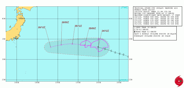
To the east of Noru is Tropical Storm Kulap (09W). Kulap is gradually weakening, and this should continue over the next few days. Kulap currently has top winds near 50 mph, but should weaken to a tropical depression by Tuesday. Kulap should continue moving off to the east, heading into the open waters of the Western Pacific.
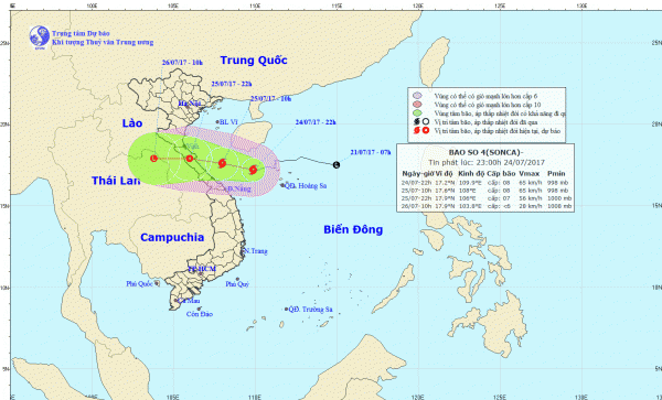
The storm that is the biggest threat to populated areas at the moment is Tropical Storm Sonca (08W). Sonca is currently centered about 160 miles east-northeast of Da Nang, Vietnam, moving towards the southwest at 4 mph. A turn more towards the west is expected over the next 24 hours, with landfall in Vietnam expected by early Tuesday. Sonca has maximum sustained winds near 45 mph, and some additional strengthening is possible before landfall. The biggest threat from Sonca is flooding from heavy rains. Sonca could produce rainfall totals of 10-20 inches or more in parts of Vietnam and Laos.
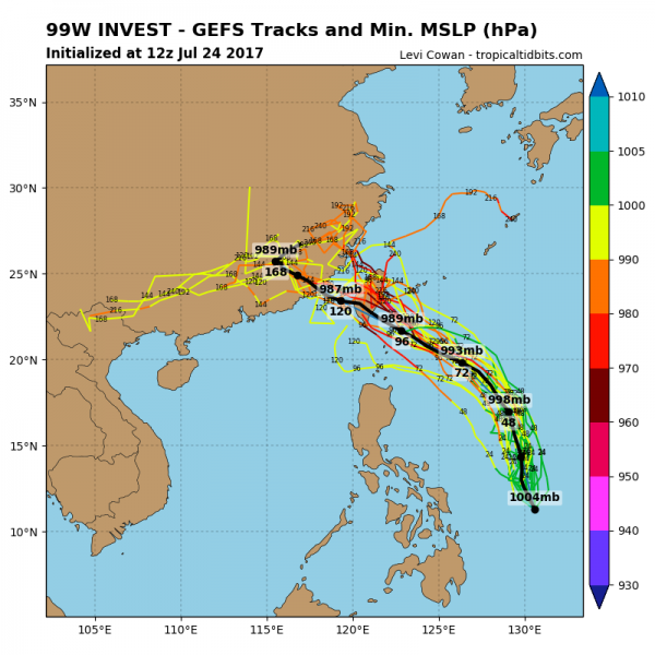
In addition to all the active systems, an area of disturbed weather about 375 miles northwest of Palau in the Western Pacific Ocean is being monitored for development. Conditions should be favorable for the system to develop over the next few days, and it could become a tropical depression later this week as it moves northward. Current computer model forecasts show the possibility of additional strengthening later this week, with the potential for a threat to the Philippines or Taiwan towards the end of the week.