Two developing storm systems will impact parts of the nation over the next several days, but that’s where the similarities end.
Two low pressure areas are developing off the East Coast this evening. The northern system is the stronger of the two, but the southern one is being monitored by the National Hurricane Center. It has the potential to develop into a tropical depression or subtropical storm over the next day or two. Whether it does or not, these two low pressure areas will eventually merge and become a rather strong non-tropical system later this week. There is very little in the way of steering currents right now, so the system will just meander around off the coast until Saturday.
As the system drifts northward, it will produce gusty winds along the coast, especially in New England. Tides are astronomically low at the moment, but will be rising later this week, so coastal flooding, while not a major concern, will still be possible in some locations. Rough seas will also be a large concern for marine interests. However, the biggest concern and also the biggest question mark right now is heavy rainfall.
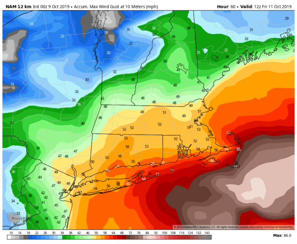
While the storm will likely spread some heavy rainfall into New England, there is still plenty of uncertainty as to how far north the heavy rain gets, as well as how much rain actually falls. Some of the models are producing extremely heavy rainfall. While these are likely overdone, the fact that most of the models are showing this potential means that some very heavy rain is likely, especially south of Boston, where flood watches have been issued.
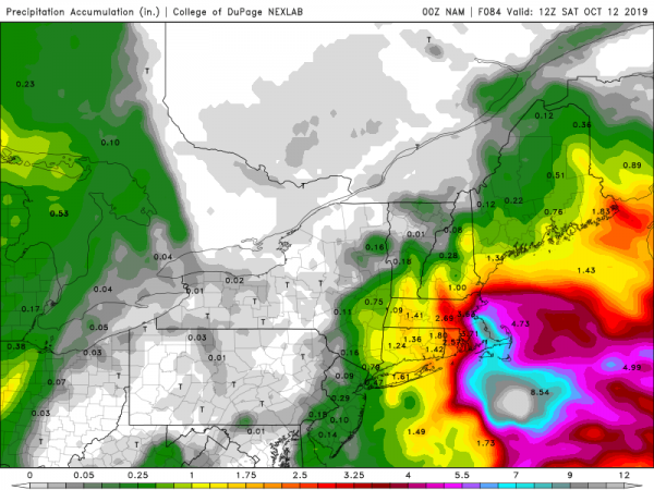
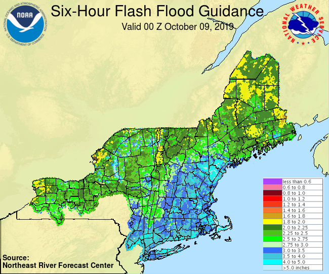
Thanks to some dry weather over the past couple of months, flash flooding is not likely. However, a prolonged period of heavy rain may still produce flooding in some areas. Strong winds will also start to take some of the leaves off of trees, which may clog up storm drains, resulting in flooding in some areas.
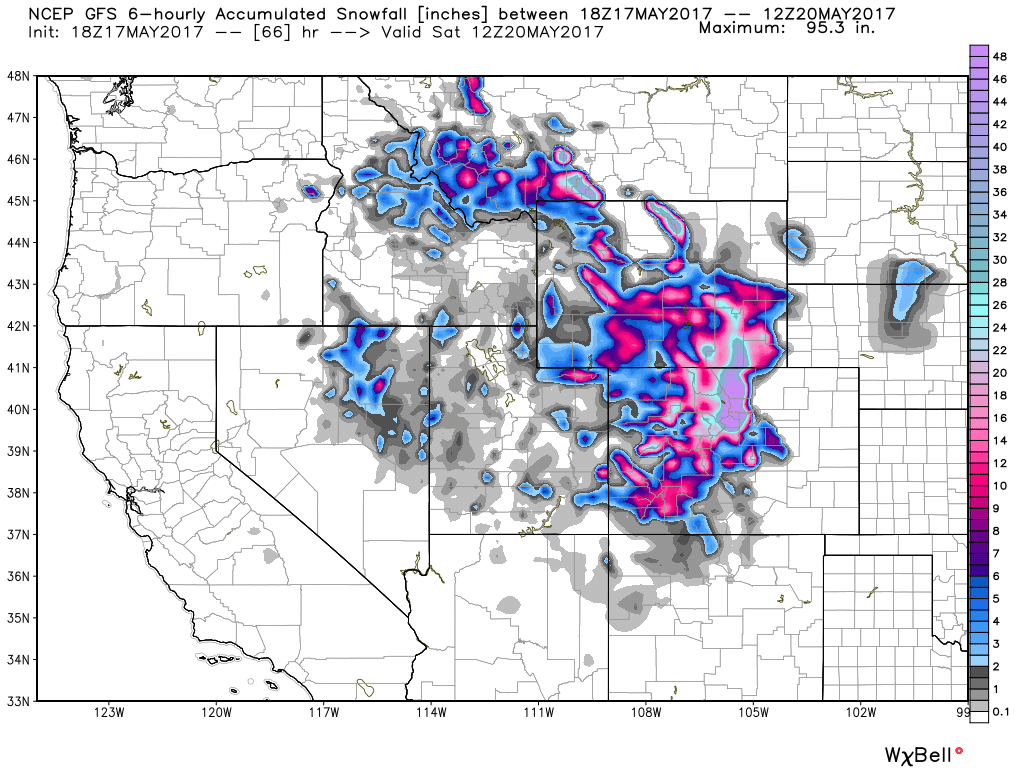
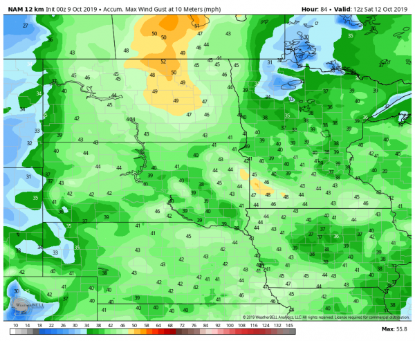
While all this is taking place off the East Coast, some of the coldest air so far this fall will settle into the Rockies and Plains states as low pressure starts to develop across the Central Plains. This system will head north-northeastward while strengthening. The system isn’t expected to become that strong, but with a large high pressure area building in behind it, it will produce some strong winds. It will also draw warm and moist air northward from the Gulf of Mexico. As this air runs into the much colder air on the backside of the storm, the first significant snowstorm of the season is expected to develop across the Northern Plains.
Winter Storm Watches and warnings have been posted from parts of Idaho Montana, and Wyoming into parts of northern Nebraska and the Dakotas as well as northwestern Minnesota. across Idaho, Montana, and Wyoming, snowfall totals of 6-12 inches are possible, with some heavier amounts in the higher elevations. The biggest issues are expected across the Dakotas and northwestern Minnesota.
The precipitation will start as rain across this area late Wednesday, but strong northerly winds will usher much colder weather in, changing the rain to snow from west to east on Thursday. Like its East Coast counterpart, this storm won’t move at a rapid pace, so snow, possibly heavy at times will continue across this area into early Saturday, with snow showers lingering into Sunday.
This storm also has some questions with it’s precipitation shield. While heavy snow is likely across a large area, how much falls and where the heaviest snow will fall is still a question. Right now, it looks like the heaviest snow will fall from central South Dakota into central and eastern North Dakota, but that still could change. As for amounts, many areas could see more than a foot, with totals in excess of 2 feet possible in many areas. The snow will be accompanied by winds gusting to 40-50 mph, resulting in blizzard conditions, especially late Thursday into Friday.
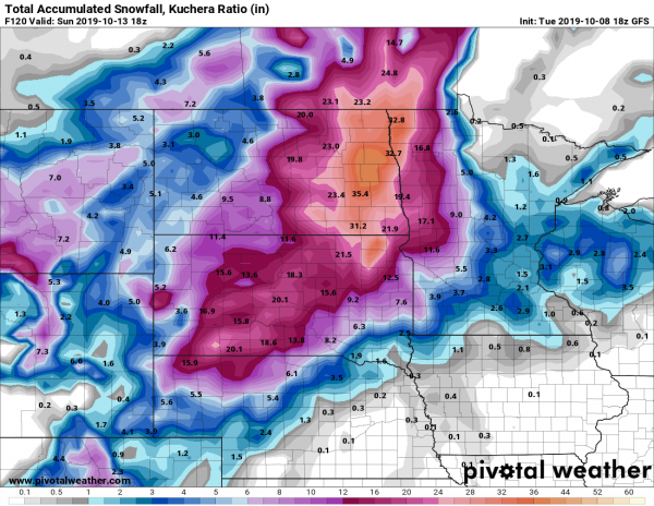
While snow in October is not unusual across this region, snowfall amounts of this magnitude this early in the year are very rare. In Grand Forks, ND, the largest October snowstorm on record occurred October 24-26, 2001, and it dropped 10.9″ on the city. In Fargo, ND, the largest October snowstorm on record is only 8.1″ on October 30-31, 1951. For Pierre, SD, the October snowstorm of record occurred October 30-31, 1943, and it only produce 7.2″ of snow. Current model forecasts are forecasting amounts that are 3-4 times the records. These model forecasts are likely too high, but it seems likely that many of these October records are going to be obliterated in the next few days.