2020-2021 Winter Outlook

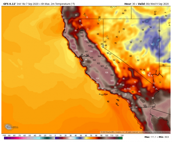
With winter-like weather making itself known already across many parts of the nation many are wondering if this is a harbinger of things to come. Record snows across Montana and temperatures nearly at record low levels for the month of October for the nation make some wonder if we’re in for a rugged winter ahead. Early snow and cold have been recorded during other Octobers over the years and the following winters have had varying results. Snowfall across New England on October 30th this year brought out those saying the winter will be a dud for snow but past data doesn’t necessarily say that’s so. Data from Lowell, MA shows varying results with some years having near to above normal snowfall while others were below normal.

There are many factors that come into play with how a winter will go and some of them change as the winter progresses leading to changeable patterns as winter evolves.

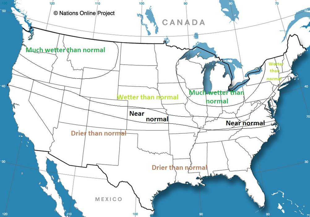
One well-advertised feature this year is the La Nina which has been well developed for several months now and is expected to remain so into the winter. Typical El Nino winters bring cold weather to the north-central U.S. and the western half of Canada while mild, dry conditions tend to prevail across the southern third of the nation. Wet weather tends to affect the Pacific Northwest and the Ohio Valley/Great Lakes region.

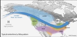
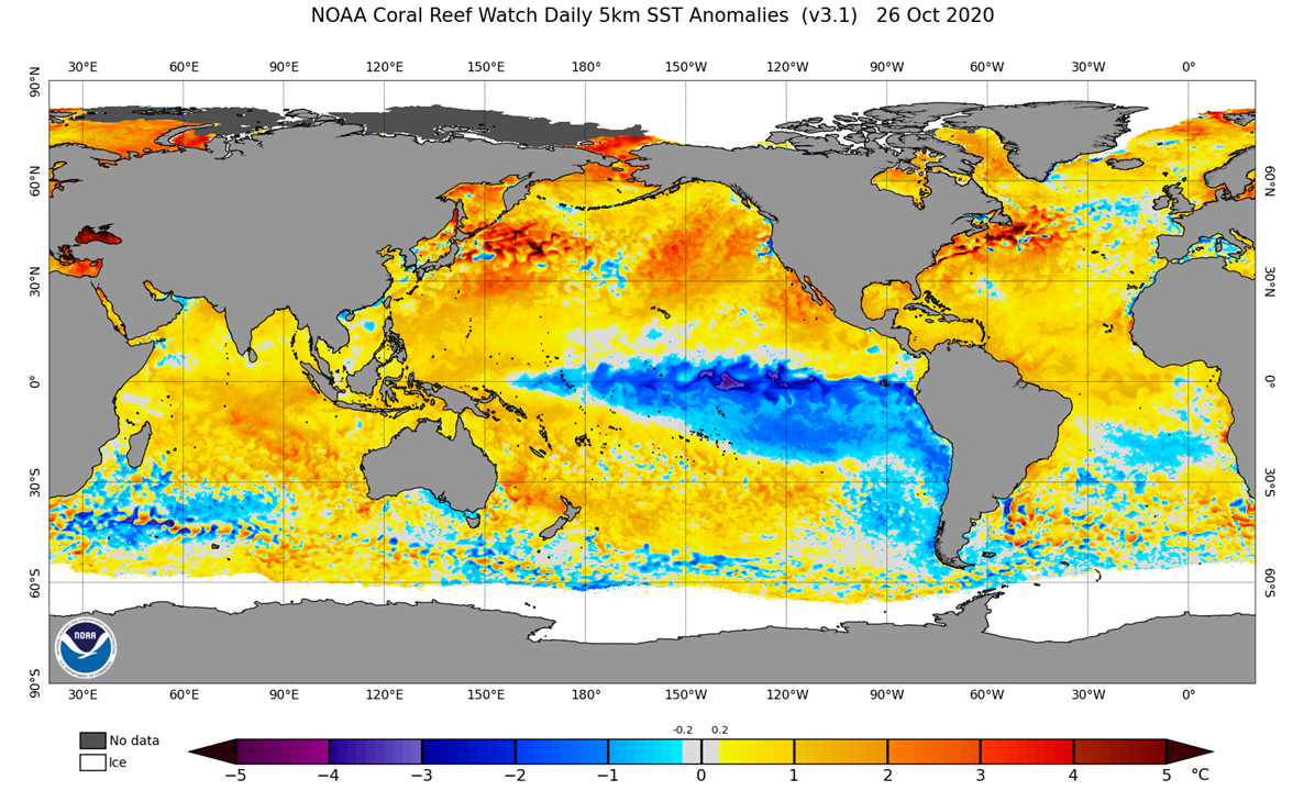
Sea surface temperatures across the Pacific show a classic La Nina with a bar of below normal (blue) near the Equator westward almost to New Guinea.

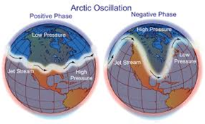
La Nina is likely to be a contributing factor with our winter weather but other influences from the Arctic Oscillation (AO), North Atlantic Oscillation (NAO), Pacific-North America Oscillation (PNA) and Pacific Decadal Oscillation (PDO) are not to be ignored either. Any of these features can disrupt or modify the La Nina pattern at times during the winter leading to different results than one might first expect. We also need to follow the Madden-Julian Oscillation which affects weather patterns over a shorter term period.

As an example we could see for a time the AO become negative and potentially create a high amplitude pattern across North America for a week or two. This would bring severe winter weather to some areas while others could be mild either wet or dry. Last winter saw a positive AO for much of the winter leading to milder the normal temperatures and many areas with less than normal snowfall.

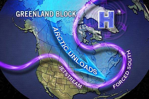
Lacking last winter was high latitude blocking. A blocking high pressure area across Greenland can lead to winter storms for the East Coast. The record early December snow of last winter was a result of Greenland blocking but that was about it for the winter.  About 50% of La Nina’s produce blocking and cold weather for New England so this is something to keep an eye on and something that could have more of an impact for the winter than we are currently forecasting.

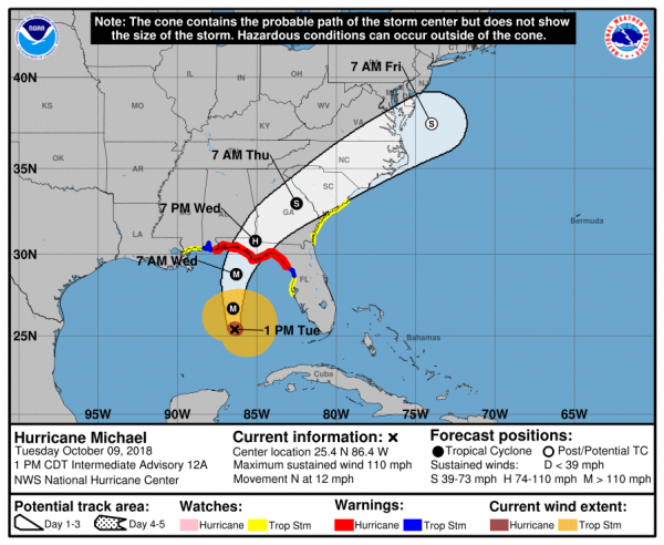
As is quite normal for a La Nina we saw an active tropical season, we’re just one storm shy of tying the record. The active tropics are indicative of above average sea surface temperatures across the Atlantic and lack of upper level shear. The above normal sea surface temperatures (SST) could help delay the start of lasting winter weather along the East Coast and Northeast. Our current spell of winter is likely due to a positive AO as well as help from the MJO but is likely to come to an end as we move into early November. With the effect of the negative AO going away we’ll see milder weather return to many parts of the nation during next few weeks and the warm SST’s to our east and southeast may aid in the warmth.

Thereafter we’ll have to monitor the different teleconnections and their interaction with the La Nina as to whether a burst of winter or spring overspreads parts of the nation. As we have just seen, a wintry pattern can set up for a week or more but can just as easily fade into a more spring-like pattern as we’re expected shortly.

Arctic sea ice is again below normal as we move into the middle of the fall.

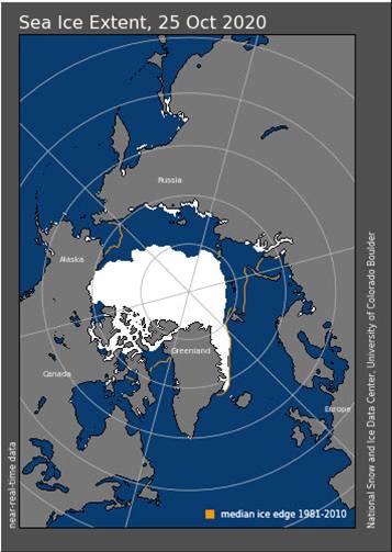
Typically a lack of arctic sea ice results in a higher amplitude jet stream which can lead to potent storms and major outbreaks of cold air. If the storm track is west of your location during one of these storms, rain, wind, and mild temperatures will be the result followed by cold air on the back side of such a storm.

This is pretty much what we’re expecting as HFS for the winter here in the Northeast. A sloppy winter with changeable temperatures and varying types of precipitation is our expected winter. Temperatures are more likely to average near or a bit above normal for the winter but that’s not to say a few blasts of arctic air won’t happen.  Temperatures can vary considerably over time, and usually do, but the average of the winter is expected to be a bit on the plus side of normal here but cold from the Great Lakes westward.

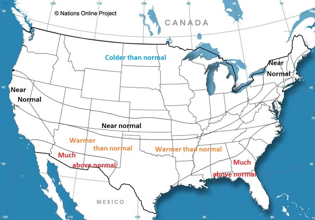
We also should keep an eye on cold air through eastern Canada that stays in place ahead of an approaching “inside runner” producing an ice storm. Ice storms are a little more prevalent during La Nina winters through these parts.  Like last winter we see potential that winter snowfall may be above normal in northern New England and below normal across far southern New England. This is a result of storms tracking over and at times west of New England resulting in a quick change to range for southern and southeastern New England while far northern New England stays snow for a longer time.


To summarize, plan on changeable weather this winter with some sloppy situations. Don’t rule out a couple of major snow makers and some ice too. Ice melt will be a good companion. Winter may lag a little slow to start but may extend through March into early April. While the temperatures may average a bit above normal over the long haul, a couple of bone-chilling blasts of arctic air should be expected as well.


September Has it All – Heat, Snow, Drought, and Tropical Storms

Autumn and Spring are the transition seasons, and September is certainly proving that right off the bat.

Intense heat has been common across much of the West for the past few days. Temperatures well over 100 degrees have been common, with numerous records set. One location, Richmond, on the eastern side of San Francisco Bay, reached 107 degrees Monday, afternoon, tying their all-time record, originally set on September 15, 1971. Several other locations set monthly records for September as well. The worst of the heat is over, but it will remain hot on Tuesday, with highs likely topping 100 across much of interior California and the Desert Southwest, possibly setting a few more records.

Another hot day is likely across interior California on Tuesday. Image provided by WeatherBell.


Heat was also common across the Plains and Rocky Mountains over the weekend, but big changes are developing thanks to a strong cold front. Denver set a record high of 97 on Sunday, then reached 93 on Monday. On Tuesday, that 93 will get reversed with a high closer to 39. On top of that, accumulating snow is likely. Even by Denver standards, this is quite early in the year for snow. Their all-time record for earliest snow is September 3, 1961, but on average Denver doesn’t see it’s first flakes until October 18. This won’t be the 1st time that Denver hit 90 one day and then had measurable snow the next. On September 12, 1993, Denver recorded a high of 92 degrees, and on September 13, they had 5.4″ of snow.

While a few inches of snow are likely in Denver and onto the adjacent High Plains of eastern Colorado and western Nebraska, heavier snow is likely across the mountains on Colorado and Wyoming. Across the higher elevations, snowfall totals in excess of a foot are likely.

Heavy snow is likely across the Central Rockies on Tuesday. Image provided by the College of DuPage.


While the snow gets the headlines, the cold air behind the front will be making headlines of its own. The first frost and freeze of the season is likely across the Dakotas Tuesday and/or Wednesday morning, with lows in the upper 20s and 30s. The cold air will continue to push southward across the Great Plains during the day on Tuesday, with numerous record lows expected Wednesday morning as far south as the Texas Panhandle.

Record lows are likely across the Plains and the Rockies Wednesday morning. Image provided by Weathermodels.com


While plenty of precipitation is expected across the Rockies, the lack of it is causing problems across the Northeast. Aside from a few showers with a cold front on Thursday, generally dry weather is expected across much of New England this week. This shouldn’t be a surprise, as precipitation has been generally below to well below normal across the region since the Spring. In some areas, the amount of rain has only been around 50-60% of normal. Drought conditions have developed across nearly all of New England, and for a good portion of the region, it is now considered a severe drought. What the region needs is a series of systems that can produce moderate rainfall to help alleviate the drought, but prospects for that aren’t promising at this time. In fact, rainfall looks to remain below normal for much of the remainder of September.

Severe drought conditions have developed across parts of New England. Image provided by the National Drought Mitigation Center.


Meanwhile, as we approach the climatological peak of hurricane season, the Atlantic is once again getting more active. Tropical Storms Paulette and Rene both developed on Monday in the central and eastern Atlantic respectively. Paulette is expected to remain a tropical storm for the next several days while remaining over open water. It is not expected to be a threat to land. Meanwhile, Tropical Storm Rene moved through the Cabo Verde Islands Monday night, producing heavy rain and gusty winds. It will likely strengthen over the next couple of days, possibly becoming a hurricane later this week. Once it pulls away from the Cabo Verde Islands it is also expected to remain over open water for much of this week, presenting no additional threat to land.

Satellite loop showing Tropical Storms Paulette and Rene in the central and eastern Atlantic. Loop provided by Tropical Tidbits. (Click for Loop)


Those systems aren’t the only ones in the Atlantic that are being watched. An area of low pressure a couple of hundred miles southwest of Bermuda is expected to drift westward over the next few days. Some development of the system is possible. It may bring some rainfall into parts of the Carolinas and Southeast late this week. The other area that is being watched isn’t apparent right now, as it is still over western Africa. A tropical wave is expected to emerge from the west coast of Africa late this week. Forecast models show the potential for this wave to develop rather quickly once it moves into the Atlantic. It could threaten the Cabo Verde Islands over the weekend.

Models show the potential for 2 tropical systems to develop over the next several days. Image provided by the University at Albany.


The peak of hurricane season is during the middle to latter half of September. Given how active this season has been so far, there will likely be more systems developing. There are only 4 names left on this list for this season – Sally, Teddy, Vicky, and Wilfred. Once the list is exhausted, the Greek alphabet is used. This has only happened once before – in 2005. During that season, there were 28 named storms of which 15 became hurricanes.

Easter Sunday Severe Weather in the South, Windy Monday in the Northeast

A rather strong storm system will wreak all sorts of havoc on a large swath of the nation through the weekend and into Monday.

Low pressure is moving into the Plains states today, producing some strong to severe thunderstorms from Texas into the Southern Plains. That’s just the start of what will be a busy few days. As the storm moves into the southern Plains tonight, showers and thunderstorms, some strong to severe, will spread from Texas into the Mississippi Valley. To the north, snow is expected across the Central Plains. Some locations could pick up 6-12 inches this weekend in a swath from Nebraska and South Dakota into parts of Iowa, southern Minnesota, and Wisconsin.

Easter Sunday is the day that will likely grab most of the headlines away from the pandemic for a day. As the system moves into the Ohio Valley, warm, moist air will be drawn northward from the Gulf of Mexico, and as this clashes with the cold air advancing southward behind the storm, the ingredients will be in place for a severe weather outbreak. Severe weather may be ongoing as Easter Sunday dawns across the Lower Mississippi Valley, but activity will spread eastward during the day across the Deep South and the Tennessee Valley. Some of the stronger storms may produce damaging winds, large hail, torrential downpours, and likely numerous tornadoes. The risk will continue well into the overnight hours, especially in Georgia, eastern Tennessee and western portions of the Carolinas.

A severe weather outbreak is possible across a large portion of the South on Easter Sunday. Image provided by the Storm Prediction Center.


By Monday, the system will move into Ontario, dragging a strong cold front across the Eastern United States. Warm, humid air will continue to flow northward ahead of this front, triggering more showers and thunderstorms during the morning and early afternoon from northern Florida into the Mid-Atlantic states. Some of these storms could produce hail, strong winds, heavy downpours, and some tornadoes, especially from the Carolinas to the Delmarva Peninsula.

The severe weather threat shifts to the East Coast on Monday. Image provided by the Storm Prediction Center.


To the north, heavy snow will continue behind the storm from northern Wisconsin into the Upper Peninsula of Michigan and Ontario. Snowfall totals of 10-20 inches or more are likely. Winds gusting to 40-50 mph will create significant blowing and drifting of the snow, with blizzard conditions at times.

Heavy snow is likely from Wisconsin in the Upper Peninsula of Michigan Sunday into early Tuesday. Image provided by Weathermodels.com


In the Northeast, the big story will be the wind. Rain will be a secondary concern, with rainfall totals of 1-2 inches or more possible across much of the region. Some embedded thunderstorms may produce heavier downpours, especially in western New England and eastern New York, but flooding isn’t much of a concern. Precipitation has been below normal across much of the area through a good chunk of the winter and early Spring, so the region needs all the rain it can get, though maybe not quite this much at once. There will be some ponding on the roadways, and some of the smaller streams may overflow, but widespread flooding shouldn’t be a problem. The wind, on the other hand, will be a major problem.

Precipitation has been below normal across much of the Northeast during the first 100 days of 2020. Image provided by the Northeast Regional Climate Center.


As the system gets cranked up in Ontario, strong southerly winds will develop across the region. These will bring milder air into the region. We won’t quite reach the 90s that will set records across Florida on Monday, but 50s and 60s are still a bit above normal for mid-April around here. Southerly winds will increase Monday morning, with sustained winds of 25-35 mph expected during the afternoon. Wind gusts of 60-70 mph or higher are expected as well. This will likely result in power outages as they take down trees that are starting to show their leaves, along with power lines. Winds should start to diminish during the evening as a cold front moves through, bringing an end to the rain and shifting the winds into the west.

Wind gusts of 60-70 mph or higher could be widespread across the Northeast Monday afternoon. Image provided by WeatherBell.


Conditions should improve on Tuesday across the Northeast as high pressure builds in with some sunshine developing, but it will still be breezy as the now-powerful storm moves into northern Quebec, where heavy snow will likely continue.

Heavy Rain for New England, Heavy Snow for the Dakotas

Two developing storm systems will impact parts of the nation over the next several days, but that’s where the similarities end.

Two low pressure areas are developing off the East Coast this evening. The northern system is the stronger of the two, but the southern one is being monitored by the National Hurricane Center. It has the potential to develop into a tropical depression or subtropical storm over the next day or two. Whether it does or not, these two low pressure areas will eventually merge and become a rather strong non-tropical system later this week. There is very little in the way of steering currents right now, so the system will just meander around off the coast until Saturday.

As the system drifts northward, it will produce gusty winds along the coast, especially in New England. Tides are astronomically low at the moment, but will be rising later this week, so coastal flooding, while not a major concern, will still be possible in some locations. Rough seas will also be a large concern for marine interests. However, the biggest concern and also the biggest question mark right now is heavy rainfall.

Wind gusts in excess of 50 mph are possible across much of Southern New England. Image provided by WeatherBell.

While the storm will likely spread some heavy rainfall into New England, there is still plenty of uncertainty as to how far north the heavy rain gets, as well as how much rain actually falls. Some of the models are producing extremely heavy rainfall. While these are likely overdone, the fact that most of the models are showing this potential means that some very heavy rain is likely, especially south of Boston, where flood watches have been issued.

Rainfall forecast from the NAM model. The heaviest rain will likely fall across southeastern Massachusetts. Image provided by the College of DuPage.

Thanks to some dry weather over the past couple of months, flash flooding is not likely. However, a prolonged period of heavy rain may still produce flooding in some areas. Strong winds will also start to take some of the leaves off of trees, which may clog up storm drains, resulting in flooding in some areas.

Recent dryness means that flash flooding is not likely in New England with this storm. Image provided the the Northeast River Forecast Center.

While all this is taking place off the East Coast, some of the coldest air so far this fall will settle into the Rockies and Plains states as low pressure starts to develop across the Central Plains. This system will head north-northeastward while strengthening. The system isn’t expected to become that strong, but with a large high pressure area building in behind it, it will produce some strong winds. It will also draw warm and moist air northward from the Gulf of Mexico. As this air runs into the much colder air on the backside of the storm, the first significant snowstorm of the season is expected to develop across the Northern Plains.

Winter Storm Watches and warnings have been posted from parts of Idaho Montana, and Wyoming into parts of northern Nebraska and the Dakotas as well as northwestern Minnesota. across Idaho, Montana, and Wyoming, snowfall totals of 6-12 inches are possible, with some heavier amounts in the higher elevations. The biggest issues are expected across the Dakotas and northwestern Minnesota.

Wind gusts of 40-50 mph or more are expected across the Northern Plains. Image provided by WeatherBell.

The precipitation will start as rain across this area late Wednesday, but strong northerly winds will usher much colder weather in, changing the rain to snow from west to east on Thursday. Like its East Coast counterpart, this storm won’t move at a rapid pace, so snow, possibly heavy at times will continue across this area into early Saturday, with snow showers lingering into Sunday.

This storm also has some questions with it’s precipitation shield. While heavy snow is likely across a large area, how much falls and where the heaviest snow will fall is still a question. Right now, it looks like the heaviest snow will fall from central South Dakota into central and eastern North Dakota, but that still could change. As for amounts, many areas could see more than a foot, with totals in excess of 2 feet possible in many areas. The snow will be accompanied by winds gusting to 40-50 mph, resulting in blizzard conditions, especially late Thursday into Friday.

Snowfall totals of 1-2 feet or more are possible across the Dakotas. Image provided by Pivotal Weather.

While snow in October is not unusual across this region, snowfall amounts of this magnitude this early in the year are very rare. In Grand Forks, ND, the largest October snowstorm on record occurred October 24-26, 2001, and it dropped 10.9″ on the city. In Fargo, ND, the largest October snowstorm on record is only 8.1″ on October 30-31, 1951. For Pierre, SD, the October snowstorm of record occurred October 30-31, 1943, and it only produce 7.2″ of snow. Current model forecasts are forecasting amounts that are 3-4 times the records. These model forecasts are likely too high, but it seems likely that many of these October records are going to be obliterated in the next few days.

Massive storm sparks blizzard warnings from Colorado to Minnesota

This article originally appeared in the Los Angeles Times on April 10.

A potentially record-breaking storm is squeezing the warmth from spring as it brings snow and howling winds across the U.S. Great Plains and threatens to flood rivers from Canada to the Gulf of Mexico.

The giant system, set to strengthen Wednesday, has sparked blizzard warnings from Colorado to Minnesota and could drop more than 2 feet of snow in South Dakota and as much as 8 inches in Minneapolis, the National Weather Service said. Severe thunderstorms will hit Texas and the Mississippi Valley. The system threatens to delay wheat and corn planting.

“It is pretty extensive,” David Roth, a senior branch forecaster at the U.S. Weather Prediction Center, said by telephone.

The storm, which will pack near-record low pressure, could be on par with the massive system that triggered flooding across Nebraska and Iowa last month. Snow and rain area already falling across the Great Plains and Midwest. The storm will build over Wyoming on Wednesday, cross Nebraska on Thursday and then hit Minneapolis, said Rob Carolan, owner of Hometown Forecast Services.

Farther south, the storm will push dry winds across Kansas, Oklahoma, New Mexico and Texas — raising the risk of wildfires.

The Mississippi River is already at moderate-to-major flood stage in Wisconsin, Illinois and Iowa. The Red River is at major flood stage in Fargo, N.D.

“Because the Mississippi is flooding — none of this is welcome,” Roth said.

Nonetheless, the Mississippi should be able to handle this week’s storm, because water levels are currently falling, said Matt Roe, spokesman for the Army Corps of Engineers in New Orleans. The Corps has begun to close the Bonnet Carre spillway upstream from New Orleans, designed to prevent flooding.

High water has restricted Mississippi barge traffic to daylight and has limited the amount of freight that can be hauled, said Austin Golding, president of Golding Barge Line in Vicksburg, Miss. Right now, the river is entirely navigable, but the hardest parts to traverse are the bridges in Vicksburg and Baton Rouge.

“May will be nasty if it gets hot up north and the snow melt accelerates after this winter system they are encountering now,” Golding said.

This system’s icy reach won’t extend to Chicago, which will get rain and have a low of 39 degrees Wednesday before temperatures rebound into the 60s by Thursday. Detroit and Toronto will also be spared, Carolan said.

As the storm passes, weather will whiplash between extremes in many places. On Tuesday, Denver’s temperature reached 78 degrees. Wednesday, however, the city is under a blizzard warning with readings set to plunge to 21, the weather service said. Cheyenne, Wyo., will go from 71 on Tuesday to 18 degrees late Wednesday.

While the storm bulldozes across the central U.S., mild air on the East Coast will keep temperatures in New York in the high 50s and low 60s through the rest of the week, the weather service said.

The snow and rain across the northern Midwest will delay corn and wheat planting, said Dan Hicks, a meteorologist with Freese-Notis Weather Services in Des Moines, Iowa. Farther south, from Kansas to Southern Illinois, planting is unlikely to be interrupted.

M is for Mayhem

For the third year in a row, the “M” storm in the Atlantic is prepared to wreak havoc on a populated area, but Michael isn’t the only headline maker in the weather at the moment.

Hurricane Michael isn’t the only storm in the news, but it is the biggest threat at the moment. As of early Tuesday afternoon, Michael was centered about 335 miles south of Panama City, Florida, moving toward the north at 12 mph. Maximum sustained winds are near 110 mph, making Michael a Category 2 Hurricane. Additional strengthening is expected over the next 12-18 hours as the storm moves over the warm waters of the eastern Gulf of Mexico. Hurricane and Storm Surge Warnings are in effect for the Florida Panhandle and the Big Bend area of Florida, with Tropical Storm Warnings and Watches surrounding the Hurricane Warnings. Tropical Storm Watches are also in effect for the Atlantic coast from northeastern Florida into South Carolina.

Forecast track for Hurricane Michael. Image provided by the National Hurricane Center.

Michael is expected to make landfall in the Florida Panhandle Wednesday afternoon, likely as a Category 3 storm. Strong winds, torrential rainfall, storm surge, and some tornadoes are all possible with this storm. Unlike Florence, which hung around the Carolinas for days and dumped incredible amounts of rainfall on the region, Michael is expected to keep moving at a steady pace, emerging off the Mid-Atlantic coast by Friday morning. Rainfall totals of 5-10 inches are still expected in parts of the region, which will produce flooding in some areas, especially in Carolinas, where many areas are still recovering from Florence. Right along the coast, a storm surge of 6-12 feet is possible, especially in the Big Bend area of Florida. Fortunately, this area is not heavily populated, but for the residents that do live in this area, storm surge flooding is a significant threat.

This is the 3rd year in a row that the “M” storm is expected to result in significant damage to a populated area. In 2014, Category 5 Hurricane Matthew left a path of death and destruction across parts of Haiti, Cuba, the Bahamas, and eventually parts of the southeastern United States. Last year, Category 5 Hurricane Maria devastated the northeastern Caribbean, including Puerto Rico and the US Virgin Islands. While Michael is not expected to become a Category 5 storm, it is still expected to result in significant damage to parts of Florida and the Southeast.

Satellite loop of Tropical Storm Leslie. Loop provided by NOAA.

Meanwhile, in the eastern Atlantic, Tropical Storm Leslie refuses to go away. As of midday Tuesday, Leslie was centered a little more than 1000 miles west-southwest of the Azores, moving toward the south-southeast at 13 mph. Maximum sustained winds are near 65 mph. The forecast for Leslie calls for a turn more toward the east over the next few days while it strengthens back into a hurricane. Leslie is expected to remain over open waters for the next few days, and could become an extratropical storm this weekend while continuing on a general easterly track.

To the south, Tropical Storm Nadine as formed nearly 500 miles southwest of the Cabo Verde Islands. Nadine has maximum sustained winds near 40 mph, and is moving toward the west-northwest at 9 mph. Nadine is expected to remain fairly weak over open waters for the next several days while turning more toward the northwest. As it moves over colder water late this week and this weekend, it should weaken and eventually dissipate.

Back in the United States, unseasonably warm conditions remain in place across much of the eastern half of the nation. Temperatures are in the 70s and 80s across much of the region, which is 15 to 25 degrees above normal. A strong frontal system is located in the Plains states this afternoon, separating the warm air in the East, from much cooler weather behind it in the Plains and the Rockies. Right along this front, which hasn’t moved much for the past 24 hours, severe weather and heavy rainfall are common this afternoon.

National radar loop from early Tuesday afternoon. Loop provided by Weathertap.

Several tornadoes have been reported already today, including a few in the Oklahoma City area, and more are expected later today and tonight. Heavy rainfall is also expected from Texas into the Central Plains and parts of the Upper Midwest. Rainfall totals of 1-3 inches and locally heavier may produce flash flooding in some areas. Flash flood watches are in effect for much of the region.

Snowfall forecast through Thursday morning from the WRF model. Image provided by Pivotal Weather.

On the other side of the front, where much cooler weather is in place, rain is expected to change over to snow as low pressure rides along the front and into the Midwest. Winter weather advisories have already been posted for parts of the region. Snow is already falling in parts of Colorado this afternoon, and several inches may fall over the next 36-48 hours from western portions of Kansas and Nebraska into the Dakotas and northern Minnesota.

HFS in the News

With back-to-back-to-back Nor’easters hitting the Northeast in March (and possibly more on the way?), HFS Chief Meteorologist Rob Carolan has been quoted in several news stories for his expertise on each storm:

When a Nor’easter slammed New England with devastating coastal flooding on March 1, Bloomberg turned to Rob Carolan with some questions:

The slow speed of the storm will make matters worse, said Rob Carolan, a meteorologist with Hometown Forecast Services in Nashua, New Hampshire. Its progress will be blocked by other weather patterns, preventing it from slipping quickly away into the Atlantic so the storm will be able to pound against the coast.

The full article can be found here:
https://www.bloomberg.com/news/articles/2018-03-01/nor-easter-set-to-rake-u-s-east-coast-with-floods-high-winds

When a second storm buried the Northeast in heavy snow a week later, again, Bloomberg turned to Rob:

Ocean and elevation — the combination of both,” said Rob Carolan, a meteorologist with Hometown Forecast Services Inc. in Nashua, New Hampshire. “As you go inland you are going up in elevation and it made all the difference in the world. It was snowing there when it was raining in the city and it gave them a head start.

The full article is here:
https://www.bloomberg.com/news/articles/2018-03-07/second-nor-easter-in-a-n-y-week-strengthens-as-rush-hour-nears

Finally, when a third storm dropped up to 2 feet of snow on New England on March 13, Bloomberg again turned to Rob:

This is not a big deal for New York City, but maybe a decent storm for eastern Long Island and the Connecticut coast east of New Haven,” said Rob Carolan, meteorologist with Hometown Forecast Services Inc. in Nashua, New Hampshire.

Full article: https://www.claimsjournal.com/news/east/2018/03/12/283551.htm

Winter, Spring, and Summer – All at the Same Time

The current weather pattern across the country is one that is fairly typical of Spring. However, the results of that pattern are wintry weather in the Rockies and summer-like weather in the East. In the battlezone between the two there is plenty of severe weather, which is fairly typical of Spring.

500mb analysis map from 8am EDT May 17, shows a ridge of hgh pressure in the East and a trough of low pressure in the West. Image provided by College of DuPage.

An upper-level low pressure area will move out of the Pacific Northwest and into the nation’s midsection over the next few days. While one surface low pressure area moves into the Upper Midwest today, a second one will develop east of the Rockies and move into the Plains states on Thursday. With cold air moving in behind the system, and warm, moist air flowing northward from the Gulf of Mexico ahead of it, strong to severe thunderstorms are likely again today, Thursday, and Friday across the Plains states.

Severe weather has plagued the nation’s midsection for the past few days, with over 500 reports of severe weather between Monday and Tuesday. Nearly 30 tornadoes were reported, along with hail as large as softballs, and hundreds of reports of wind damage from gusts as high as 85 mph.

GFS model snowfall forecast through Saturday morning for the Rockies. Image provided by WeatherBell.

Behind the low pressure area, a late-season snowstorm is expected across the Rocky Mountains. Heavy snow will continue across portions of Montana and Idaho today, spreading into Wyoming and Colorado for Thursday into Friday. Across the higher elevations, totals of 1-3 feet are expected, which will keep the ski season going for a while longer. Snow may also spread into the High Plains of eastern Colorado and western Nebraska, with some minor accumulations possible. In Denver, it looks a couple of slushy inches may fall, though at least 1 model is forecasting much heavier amounts. In a normal year, Denver averages 1.7″ of snow, and the city has seen measurable snow during the month of May in 11 out of the last 16 years, so snow in May is not uncommon, though a heavy snowstorm, if it materializes, would be. Denver has only received 10 or more inches of snow in the month of May 6 times in a 135 years of records, with a record total of 15.5″ set back in May of 1898.

Record high temperatures are expected to be broken across the Northeast on Thursday. Image provided by WeatherBell.

Meanwhile, in the East, an early taste of summer is ongoing, thanks to a ridge of high pressure aloft, and a surface high pressure area off the East Coast. Temperatures soared into the 80s and lower 90s on Wednesday, setting several records, but the hottest day for many locations will be Thursday. High temperatures will climb into the lower to middle 90s in many locations, likely breaking records across much of the region. When you combine the heat with dewpoints well into the 60s, it will definitely feel like a mid-summer afternoon across the region. A cold front will move through the area of Friday, possibly triggering a few showers and thunderstorms, but also sending temperatures back to where they should be in the middle of May.


Severe Weather in the South Today, Bigger Outbreak Friday?

Severe weather is likely across portions of the Gulf Coast and Mississippi Valley today, but another, perhaps more widespread, outbreak is possible at the end of the week.

Surface analysis as of 7am CDT Wednesday April 26. Image provided by NOAA.


A strong cold front is moving into the Mississippi Valley and Texas this afternoon, and it is helping to trigger strong to severe thunderstorms across portions of the region. Ahead of the front, temperatures are into the 70s and lower 80s, with dewpoints in the upper 60s and 70s, so there’s plenty of warm, moist air in place. Behind the front, temperatures quickly drop into the 50s and 60s. Thunderstorms will continue to develop in the unstable airmass ahead of the front, with some of the storms containing large hail, heavy downpours, damaging winds, and possibly some tornadoes. Earlier this morning, some storms produced baseball-sized hail and wind gusts in excess of 70 mph in portions of Missouri, Arkansas, and Oklahoma. The threat should start to diminish across the region as we head into the overnight hours.

A more significant severe weather outbreak is possible later Friday into Saturday from the Southern Plains and Texas into portions of the Mississippi and Tennessee Valleys. Low pressure will move out of Texas and head northward, drawing warm moist air northward from the Gulf of Mexico once again. North and west of the system, much cooler air will be in place (more on that in a moment).

Models are showing that a very unstable airmass will be in place across Texas and the Lower Mississippi Valley Friday afternoon. Image provided by Pivotal Weather.

Models are showing that a very unstable airmass will be in place across Texas and the Lower Mississippi Valley Friday afternoon. Image provided by Pivotal Weather.


As low pressure rides along the boundary between the two airmasses, it will help to trigger strong to severe thunderstorms across the region. The threat will continue into the overnight hours Friday night, shifting into the Mississippi and Tennessee Valleys on Saturday as the system continues to progress northeastward. Some of the storms may produce torrential downpours that could trigger flash flooding, large hail, damaging winds, and tornadoes.

Portions of the Mississippi Valley could received 5-10 inches of rain between  Wednesday and Sunday. Image provided by WeatherBell.
Portions of the Mississippi Valley could received 5-10 inches of rain between Wednesday and Sunday. Image provided by WeatherBell.


Behind the storm, as colder air settles into the region, a different threat is evolving – heavy snow. While it’s getting late in the season, heavy snow is not uncommon in the Central and Southern Rockies at this time of year. Some of the higher elevations in Colorado and New Mexico could receive 1-2 feet of snow Friday into Saturday. East of the Continental Divide, especially in the High Plains, snow is also possible, especially from eastern Colorado and western Kansas into portions of the Oklahoma and Texas Panhandles. In Denver, there is still a big question as to whether to precipitation falls mainly as rain, snow, or a wintry mix. Some snow accumulation seems likely at this point, but it’s still a little too early to tell whether there will be heavy snow in the city itself.

GFS models forecast for snowfall through Sunday morning across the Plains and the Rockies. Image provided by WeatherBell.
GFS model forecast for snowfall through Sunday morning across the Plains and the Rockies. Image provided by WeatherBell.


Severe weather outbreaks are not uncommon at this time of year. In fact, from late March into early May is when they are most likely. The largest tornado outbreak on record occurred 6 years ago this week. Between April 25 and 28, 2011, a total of 362 tornadoes were observed from Texas to New York and portions of southern Canada, resulting in 324 fatalities, 317 of them on April 27, the most active day.

Map showing tracks of all 362 tornadoes from the April 2011 "Super Outbreak". Image provided by Encyclopedia Brittanica.
Map showing tracks of all 362 tornadoes from the April 2011 “Super Outbreak”. Image provided by Encyclopedia Brittanica.

From Record Highs to Blizzard Conditions

Much of the nation’s midsection has been enjoying temperatures more typical of April than February for the past week, with a few hundred record high temperatures broken. That is about to change, as Mother Nature will remind the region that is still February.

Numerous record highs are expected across the Plains and Midwest for one more day. Image provided by WeatherBell.

One more warm day is expected today, with highs well into the 60s and 70s likely setting more records. However, a cold front will sweep across the region, bringing an end to the record heat, and setting the stage for a snowstorm.

The low pressure system that brought more rain to California over the past couple of days will head eastward, bringing some snow into the Rockies today. As that system moves into the Plains on Thursday it will start to strengthen, drawing moisture northward from the Gulf of Mexico while cold air flows southward on the backside of the storm into the Northern Plains. Where these airmasses meet, snow will develop across the Central Plains states. The snow will be accompanied by winds of 20-30 mph, gusting to 40 mph or more at times, resulting in near-blizzard conditions across portions of South Dakota, Nebraska, southeastern Wyoming, and eastern Colorado on Thursday.

More than a foot of snow may fall in a swath from the Plains into the Upper Midwest. Image provided by Pivotal Weather.

As the system heads eastward, snow will move into portions of the Mississippi Valley and the Upper Midwest on Friday. The heaviest snow looks to stay just south of the Twin Cities, but even there, moderate to heavy snow is likely. By the time the storm moves out on Saturday, a foot or more of snow is possible in a swath from the Central Plains into the Great Lakes.

Snow isn’t the only threat from this system. As the storm moves eastward, record warmth will remain in place across the Midwest. With warm, moist air in place and a strong cold front approaching from the West, strong to severe thunderstorms are possible across portions of the Lower Great Lakes and Ohio Valley on Friday. Some of the stronger storms that form may contain damaging winds, hail, and possibly tornadoes.

The Storm Prediction Center has already highlighted the Midwest as an area to watch for severe weather on Friday. Image provided by NOAA.

The system will continue to move eastward, bringing some rain to the East Coast on Saturday, but amounts should be fairly light, and additional severe weather is not anticipated.

Back to top