Autumn and Spring are the transition seasons, and September is certainly proving that right off the bat.
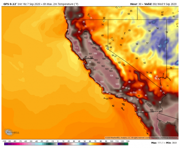
Intense heat has been common across much of the West for the past few days. Temperatures well over 100 degrees have been common, with numerous records set. One location, Richmond, on the eastern side of San Francisco Bay, reached 107 degrees Monday, afternoon, tying their all-time record, originally set on September 15, 1971. Several other locations set monthly records for September as well. The worst of the heat is over, but it will remain hot on Tuesday, with highs likely topping 100 across much of interior California and the Desert Southwest, possibly setting a few more records.
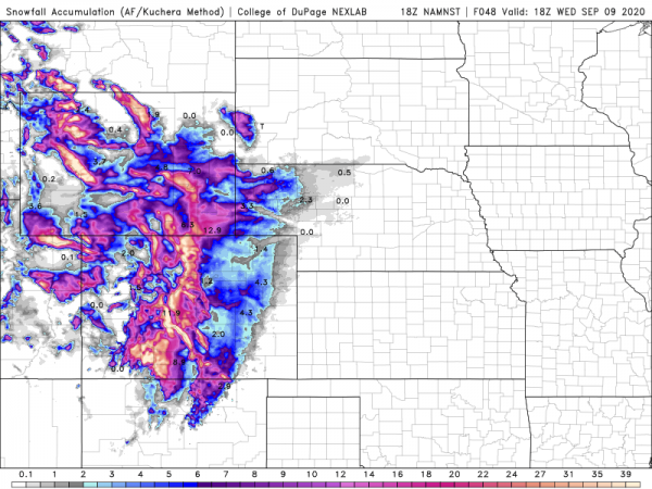
Heat was also common across the Plains and Rocky Mountains over the weekend, but big changes are developing thanks to a strong cold front. Denver set a record high of 97 on Sunday, then reached 93 on Monday. On Tuesday, that 93 will get reversed with a high closer to 39. On top of that, accumulating snow is likely. Even by Denver standards, this is quite early in the year for snow. Their all-time record for earliest snow is September 3, 1961, but on average Denver doesn’t see it’s first flakes until October 18. This won’t be the 1st time that Denver hit 90 one day and then had measurable snow the next. On September 12, 1993, Denver recorded a high of 92 degrees, and on September 13, they had 5.4″ of snow.
There are 14 instances of a “major” climate station reaching 90°F one calendar day and having measurable snow the next (since 1900). Denver topped 90°F today and is forecast to have snow tomorrow. #cowx pic.twitter.com/nK7wfc7EY8
— Brian Brettschneider (@Climatologist49) September 7, 2020
While a few inches of snow are likely in Denver and onto the adjacent High Plains of eastern Colorado and western Nebraska, heavier snow is likely across the mountains on Colorado and Wyoming. Across the higher elevations, snowfall totals in excess of a foot are likely.
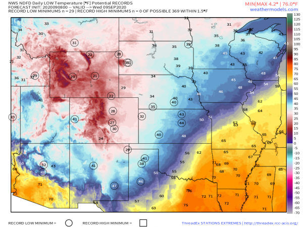
While the snow gets the headlines, the cold air behind the front will be making headlines of its own. The first frost and freeze of the season is likely across the Dakotas Tuesday and/or Wednesday morning, with lows in the upper 20s and 30s. The cold air will continue to push southward across the Great Plains during the day on Tuesday, with numerous record lows expected Wednesday morning as far south as the Texas Panhandle.
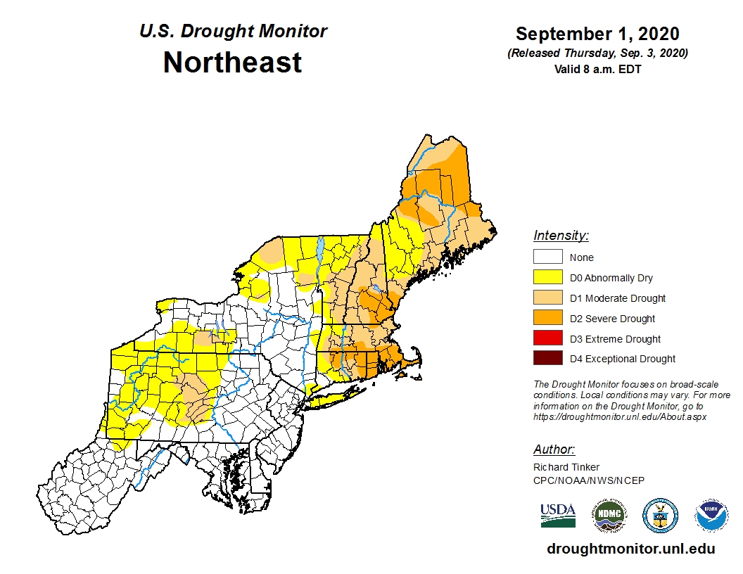
While plenty of precipitation is expected across the Rockies, the lack of it is causing problems across the Northeast. Aside from a few showers with a cold front on Thursday, generally dry weather is expected across much of New England this week. This shouldn’t be a surprise, as precipitation has been generally below to well below normal across the region since the Spring. In some areas, the amount of rain has only been around 50-60% of normal. Drought conditions have developed across nearly all of New England, and for a good portion of the region, it is now considered a severe drought. What the region needs is a series of systems that can produce moderate rainfall to help alleviate the drought, but prospects for that aren’t promising at this time. In fact, rainfall looks to remain below normal for much of the remainder of September.
Meanwhile, as we approach the climatological peak of hurricane season, the Atlantic is once again getting more active. Tropical Storms Paulette and Rene both developed on Monday in the central and eastern Atlantic respectively. Paulette is expected to remain a tropical storm for the next several days while remaining over open water. It is not expected to be a threat to land. Meanwhile, Tropical Storm Rene moved through the Cabo Verde Islands Monday night, producing heavy rain and gusty winds. It will likely strengthen over the next couple of days, possibly becoming a hurricane later this week. Once it pulls away from the Cabo Verde Islands it is also expected to remain over open water for much of this week, presenting no additional threat to land.
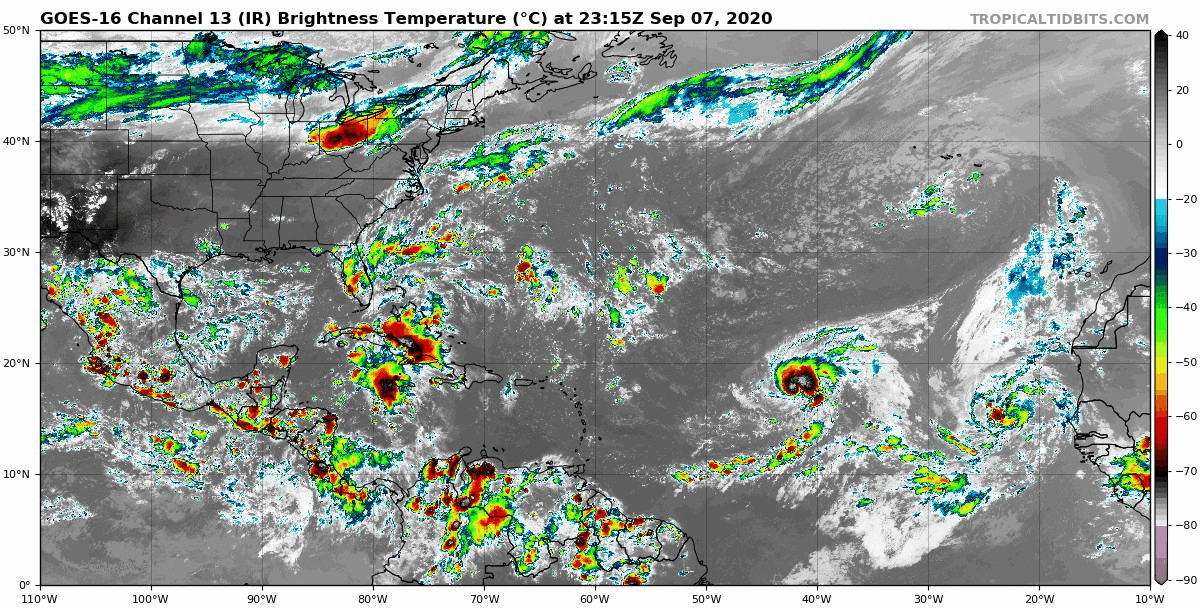
Those systems aren’t the only ones in the Atlantic that are being watched. An area of low pressure a couple of hundred miles southwest of Bermuda is expected to drift westward over the next few days. Some development of the system is possible. It may bring some rainfall into parts of the Carolinas and Southeast late this week. The other area that is being watched isn’t apparent right now, as it is still over western Africa. A tropical wave is expected to emerge from the west coast of Africa late this week. Forecast models show the potential for this wave to develop rather quickly once it moves into the Atlantic. It could threaten the Cabo Verde Islands over the weekend.
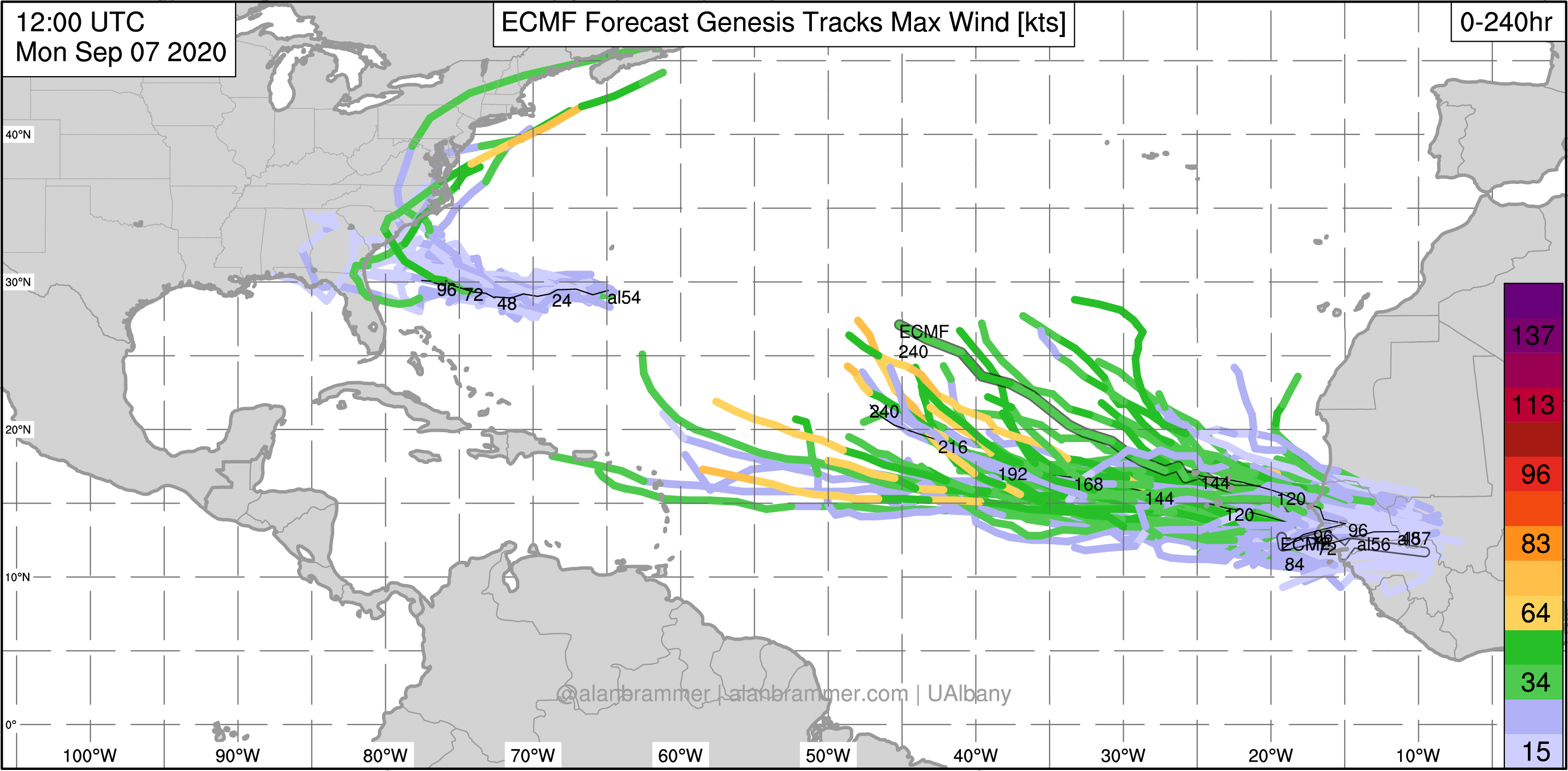
The peak of hurricane season is during the middle to latter half of September. Given how active this season has been so far, there will likely be more systems developing. There are only 4 names left on this list for this season – Sally, Teddy, Vicky, and Wilfred. Once the list is exhausted, the Greek alphabet is used. This has only happened once before – in 2005. During that season, there were 28 named storms of which 15 became hurricanes.