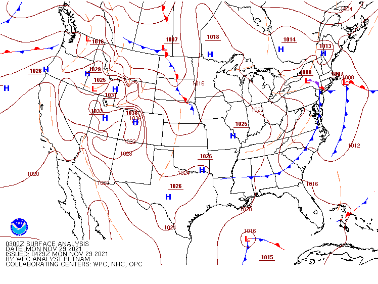
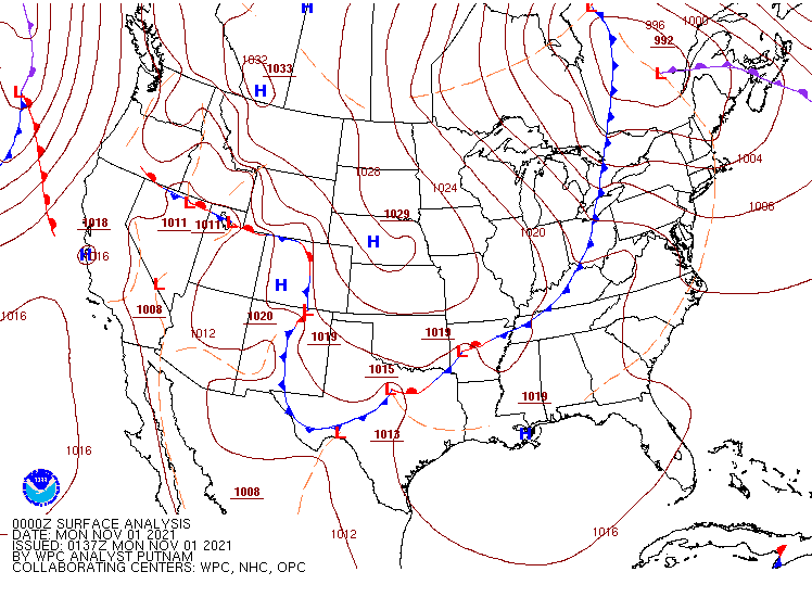
Once again, a majority of the nation will be spared from major storminess during much of the upcoming week.
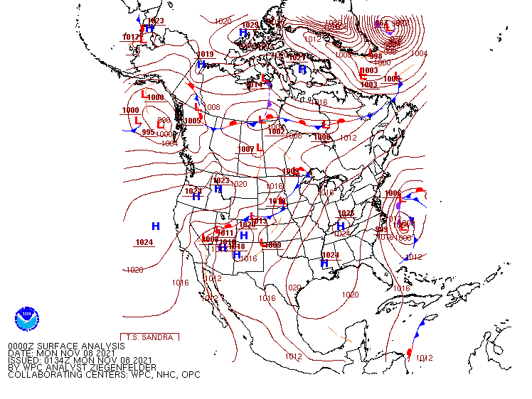
The week is starting off without any significant storm systems on the surface map. Image provided by NOAA.
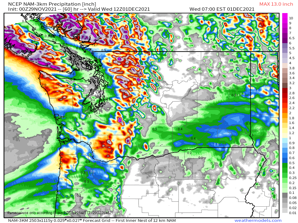
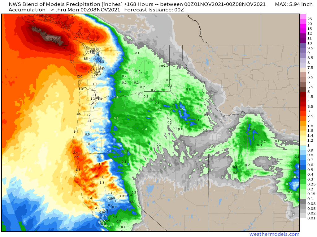
As is typically the case at this time of year, the Northwest will be the exception to the rule when it comes to quiet conditions. As one system pulls away from the region today, another one will move in from the Pacific later Tuesday into Wednesday with rain, some of it heavy, and higher elevation snow in parts of Washington and Oregon. While this rainfall won’t be anywhere near the magnitude of some recent storms, some locations, especially in the Olympic Peninsula, could see 1-3 inches of rain, which may lead to some flooding.
Some heavy rain is possible across parts of Washington State on Tuesday. Image provided by Weathermodels.com
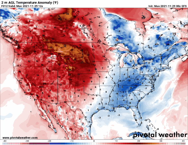
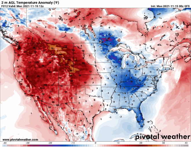
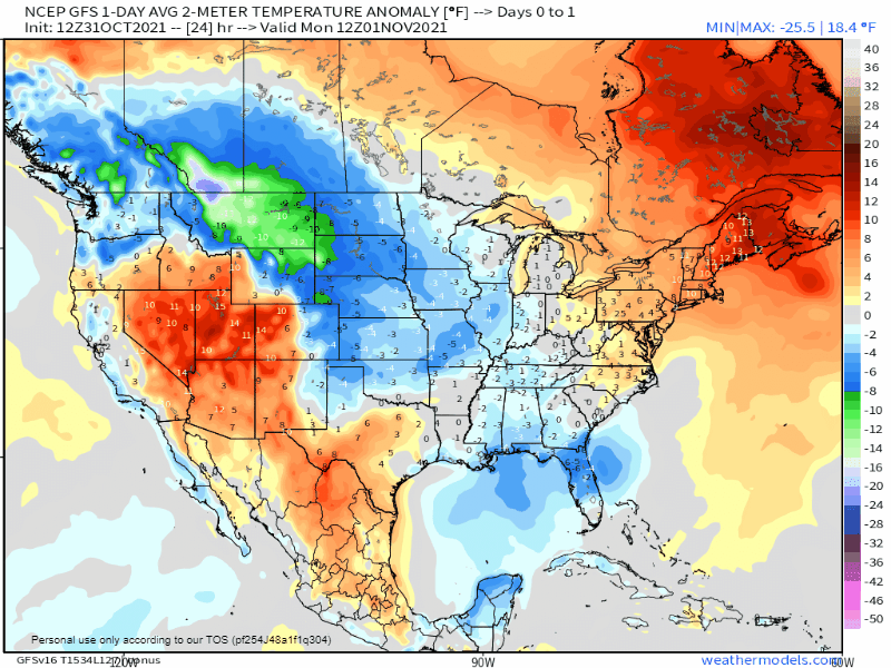
The other main story this week will be unseasonably warm weather for a large portion of the nation, especially west of the Mississippi River, for the next several days. Much of this region will have temperatures that are 15 to 30 degrees above normal through at least Thursday or Friday. Dozens of record highs are likely to be set from the Plains states into the Rockies and the Pacific Northwest, especially Wednesday and Thursday. High temperatures could top 70 as far north as parts of South Dakota and Wyoming by Thursday.
Unseasonably warm weather is expected across much of the nation this week. Loop provided by Pivotal Weather.
A cold front will drop southward out of Canada toward the end of the week, bringing an end to the warm spell. A wave of low pressure riding along the front may produce some light to perhaps moderate snow from the Northern Plains into the Great Lakes next weekend.
A quiet weather pattern is expected for a large portion of the nation for much of the upcoming week.
There are several frontal systems on the surface map to start the week, but no big storms. Image provided by NOAA.
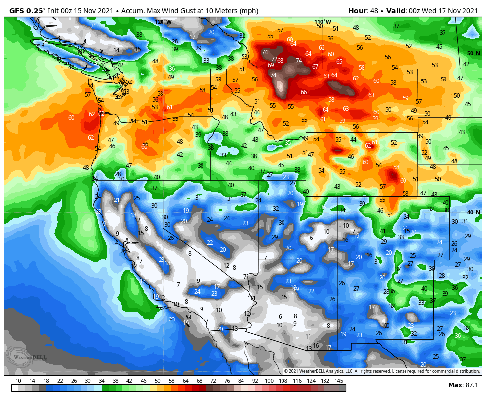
A low pressure system moving in from the Pacific will bring some heavy rain, higher elevation snow, and strong winds to the Northwest and Northern Rockies over the next few days. Flood Watches and Warnings are in effect for parts of western Washington. Rainfall totals of 1-3 inches and locally heavier are expected in parts of Washington, Oregon, and northern California. Across the higher elevations of the Cascades, snowfall totals of 1-2 feet are likely, with some heavier amounts. As the system pushes inland, valley rain and mountain snow will move into the Northern Rockies, where snowfall totals of 4-8 inches and locally heavier are possible. The bigger story here will be strong winds for Monday and Tuesday. High Wind Watches and Warnings are in effect for much of the region. Sustained winds of 20-40 mph are likely, especially in parts of Montana and Wyoming, with gusts of 50-70 mph common. Along the Rocky Mountain Front in Montana, some gusts could approach 100 mph. The system will make its way eastward along the US/Canada border during the week, with a frontal system trailing the system producing some light rain or snow, especially as it reaches the East Coast by late in the week.
Strong winds are expected from the Northwest into the Northern Rockies. Image provided by WeatherBell.
Temperatures both ahead of and behind that system will be the other big story this week. Temperatures ahead of this system will be 15-25 degrees above normal across much of the West on Monday, shifting into the Rockies and the Plains on Tuesday, the Mississippi and Ohio Valleys on Wednesday, and reaching the East Coast by Thursday. Some record highs are possible on Monday in parts on the Southwest and also in the Plains on Monday, with several records possible on Tuesday from the Southern Plains into the Texas Panhandle. Behind the system, much cooler weather is expected. While temperatures won’t be exceptionally cold, they’ll be 5-10 degrees below normal for a day or two before moderating once again.
The GFS shows the warm air progressing across the nation followed by much cooler weather. Loop provided by Pivotal Weather.
A preliminary look at the weather for travel the day before Thanksgiving and Thanksgiving Day doesn’t show much in the way of impactful conditions at this point, but a weak system could bring some light rain or snow to areas from the Northern Plains into the Great Lakes and Northeast.
A low pressure system moving into the West Coast today will impact the weather across much of the nation during the upcoming week.
The low pressure system currently in the Gulf of Alaska will be the big weather-maker this week. Image provided by NOAA.
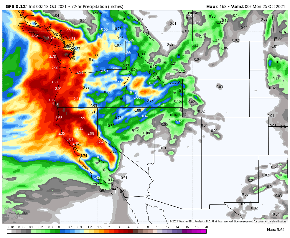
Low pressure will move out of the Pacific and into the West Coast over the next day or two, spreading rain, some of it heavy, into the Pacific Northwest as well as northern and central portions of California. While this storm will be nowhere near the magnitude of some of the storms they’ve already seen this year, rainfall totals of 1-2 inches and locally heavier in some areas may result in localized flooding. The rian will be accompanied by gusty winds. Wind Advisories and High Wind Warnings have been issued for parts of the region. Wind gusts of 40-50 mph will be common, possibly resulting in damage and power outages in some areas. Across the higher elevations of the Cascades and the Sierra Nevada, heavy snow is likely, with many areas receiving more than a foot by the time everything winds down later Tuesday.
Heavy rain is expected across parts of the Northwest and California over the next day or two. Image provided by WeatherBell.
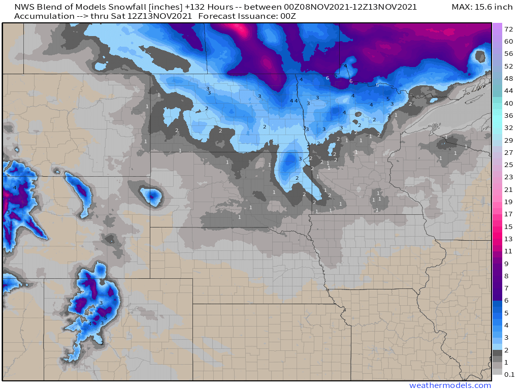
This system will weaken a bit as it moves into the Rockies by midweek, where several inches of snow is still expected. By Thursday, the system will intensify again as it moves into the Plains states. As it draws in some moisture from the Gulf of Mexico, it could produce some severe weather across parts of the Central and Southern Plains and into the Mississippi Valley ;ater Wednesday and Thursday. To the north, it will likely produce the first snowstorm of the season across the Dakotas and into parts of Minnesota late this week. Snowfall totals of 3-6 inches will be possible in parts of the region.
Several inches of snow may fall in parts of the Dakotas and Minnesota late this week. Image provided by Weathermodels.com
By the end of the week, the low pressure system will stall out near the Great Lakes, but ahead of it, a frontal system will draw moisture northward, bringing a period of heavy rain from the Tennessee and Ohio Valleys into the Mid-Atlantic states and the Northeast from Friday into Saturday.
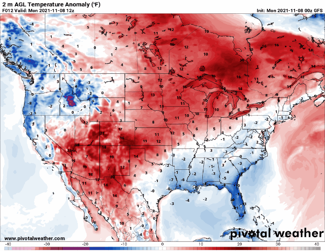
The other thing we’re paying attention to this week will be the temperature swing we’re expecting. Temperatures will run 6-12 degrees above normal across parts of the Plains states eastward to the Great Lakes over the next couple of days before the core of the milder air shifts to the East Coast later this week. Meanwhile, behind the storm system, a pool of cooler air, with readings of 4-8 degrees below normal, will move into the West during the next 2-3 days. By the time that air moves into the Plains it will intensify with temperatures running 6-12 degrees below normal across the Plains on Friday and further east by next weekend.
Mild air dominates the nation at the start of the week, but much cooler air eventually settles in. Loop provided by Pivotal Weather.
Taking a quick look ahead to the following week, there are some indications that a much cooler weather pattern may move into parts of the central and eastern US for the middle of the month.
After a fairly active week last week, a much more quiet pattern is expected for the upcoming week.
The most noteworthy feature on the weather map this morning is the strong cold front from the Great Lakes to Texas, Image provided by NOAA.
The biggest thing we’re keeping an eye on this week is the cold air that will spread across the eastern two-thirds of the nation. A strong cold front will move off the East Coast Monday morning, with the tail end of the front stalling out from the Carolinas to northern Texas. Behind this front, much cooler air has already settled into parts of the Plains states and Mississippi Valley, and it will continue to spread eastward. A series of weak cold fronts dropping out of Canada will help to usher progressively cooler into parts of the Northeast and Mid-Atlantic states as well. Temperatures will be 6-12 degrees below normal from the Northern and Central Plains into parts of the Upper Midwest for Monday and Tuesday, with the core of the colder air shifting into the region from the Southern Plains into the eastern Great Lakes for Wednesday into Friday, and the East Coast next weekend. A few record lows may be set, but widespread records are not anticipated. However, with this cold airmass settling in, the first frost and/or freeze of the fall will be possible from parts of the Deep South into the Southeast and Mid-Atlantic states later this week.
The GFS model shows the progression of the colder air across the nation over the next several days. Image provided by Weathermodels.com
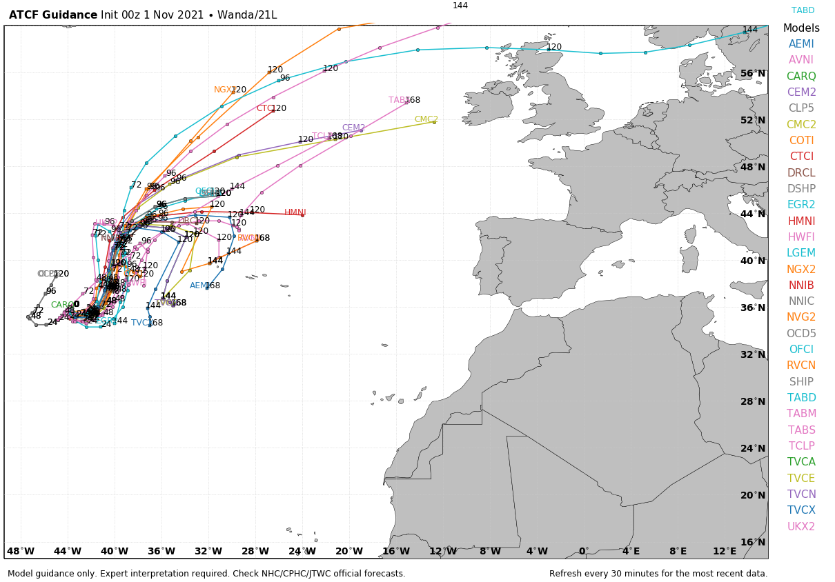
Meanwhile, in the Atlantic, we’re entering the final month of hurricane season, and although October was quiet for the most part, November is not starting off that way. The storm system that produce heavy rain and significant wind damage across the Mid-Atlantic and Northeast last Tuesday and Wednesday moved out to sea and passed south of Atlantic Canada over the past several days. During the weekend it turned southward, moved over warmer water, and began to transition from a cold-core system to a warm-core system. Early Sunday it was designated as Subtropical Storm Wanda. It is in the middle of the Atlantic, nearly 1000 miles west of the Azores with maximum sustained winds near 50 mph. While it remains over marginally warmer waters, it may complete the transition into a tropical system and strengthen a bit more over the next day or two. Later this week, the most likely scenario is for it to head northeastward over colder water, transition back into an extratropical system, possibly bringing some rainfall and gusty winds to the British Isles next weekend. However, there are some models that show the storm turning back toward the south, and possibly impact the Azores by next weekend.
Forecast model tracks for Subtropical Storm Wanda. Image provided by WeatherBell.
Elsewhere, as is usually the case as we get into this time of year, a series of storm systems will bring heavy rain and mountain snow to parts of the Pacific Northwest and British Columbia, as well as parts of northern California. None of these systems will be as extreme as the storm that impacted California last week, but they will bring beneficial rainfall to the region.
Beneficial rain is expected across the Northwest later this week. Image provided by Weathermodels.com
The only other item of note for the week ahead is the potential for the first snowflakes of the season later this week east of the Great Lakes and into the higher elevations of the Northeast and New England. Any accumulations would be light, but they would be (in most cases), the first snow of the season, which is noteworthy in and of itself.
We’re keeping an eye on a couple of things for the upcoming week across the nation.
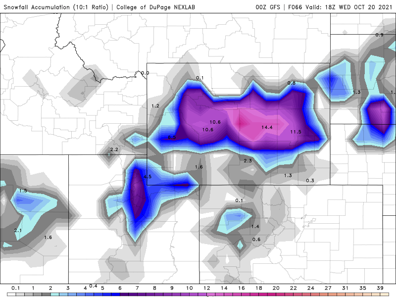
First, we’ve got a low pressure area that will move across the Great Basin and into the Rockies today and Tuesday, before it heads toward the northern Plains and Upper Midwest. While this system will likely produce snow across the higher elevations (parts of Wyoming could see more than a foot), the bigger story with the system is the temperatures both ahead of it and behind it.
Parts of Wyoming could see more than a foot of snow over the next few days. Image provided by the College of DuPage.
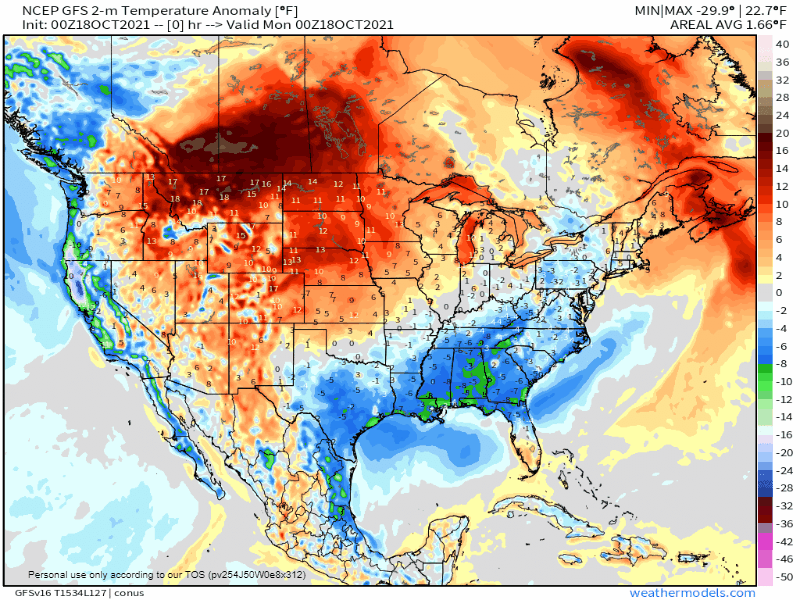
Temperatures are likely to run 15-20 degrees above normal across the Northern Plains today ahead of the system, shifting to the northern Great Lakes Tuesday. While these readings aren’t likely to set any records, they will be quite mild for mid-October. By the middle of the week, the warm air will settle into the Northeast, where temperatures will be 10-15 degrees above normal for Wednesday and Thursday. Behind the storm, temperatures will be 15-25 degrees below normal across interior California and Nevada today. That cold air will shift into the Rockies on Tuesday, where temperatures will still be 15-20 degrees below normal. As the core of the colder air moves into the Northern Plains on Wednesday, temperatures will be 10-18 degrees below normal, a significant change from what that region will experience today.
The GFS model shows the temperature anomalies over the next few days. Loop provided by Weathermodels.com
The other item we’re keeping an eye on are the twin low pressure areas that will impact the West Coast Friday and next Sunday. Heavy rain is expected into at least northern California, with the possibility of rain falling as far south of Los Angeles. Rainfall totals of 1-3 inches are possible along the coastal plain from British Columbia into Northern California, possibly even into the Bay Area. Across the higher elevations of the Cascades and Sierra Nevada, heavy snow is likely. Many locations could see more than a foot of snow.
Heavy rain is expected across the West Coast at the end of the week and the weekend. Image provided by WeatherBell.
Elsewhere, we’re not expecting much significant weather across the rest of the nation, but one other thing we’ll keep an eye on. The cooler air moving into the Plains for mid-week will make its way into the Northeast for next weekend. Some of the models are showing the possibility for some lake-effect snow downwind of Lakes Ontario and Erie toward Sunday as gusty west winds bring much cooler air across the still-warm lakes.