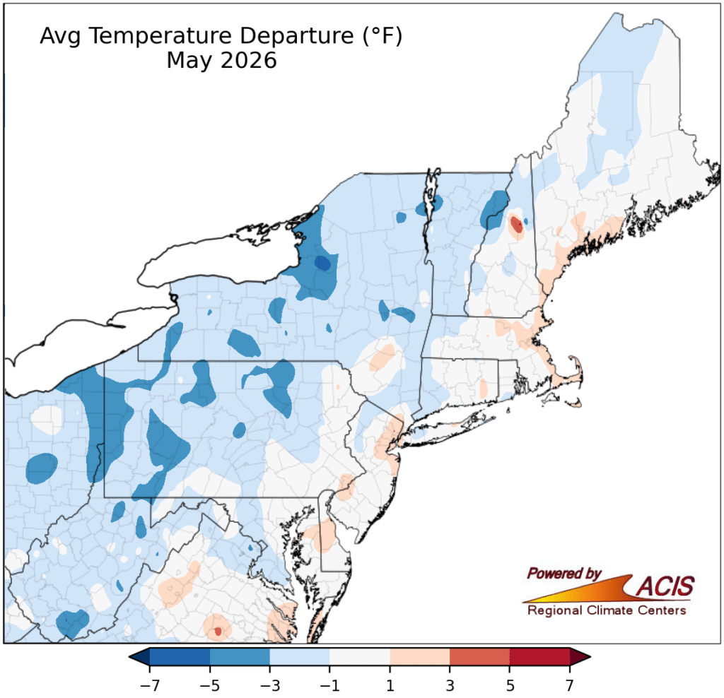
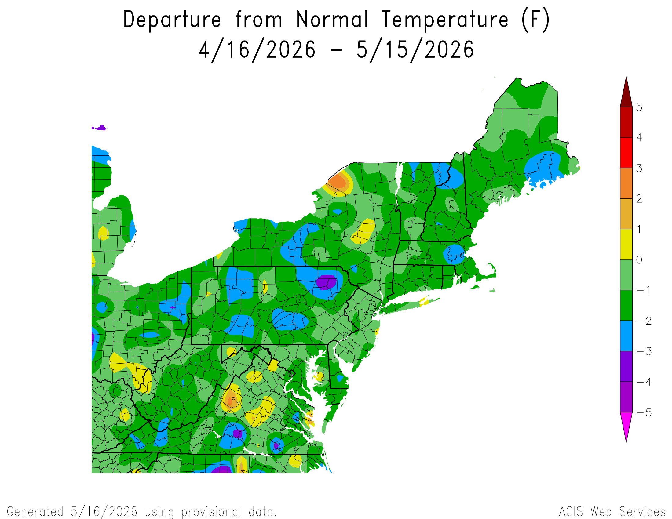
May 2026 was cooler than average for much of the Northeast, but the past week or two have seen warmer temperatures, though that might change this weekend.
Cooler temperatures were the norm for May 2026, with most of the region being at or below average temperature. Image provided by the Northeast Regional Climate Center.
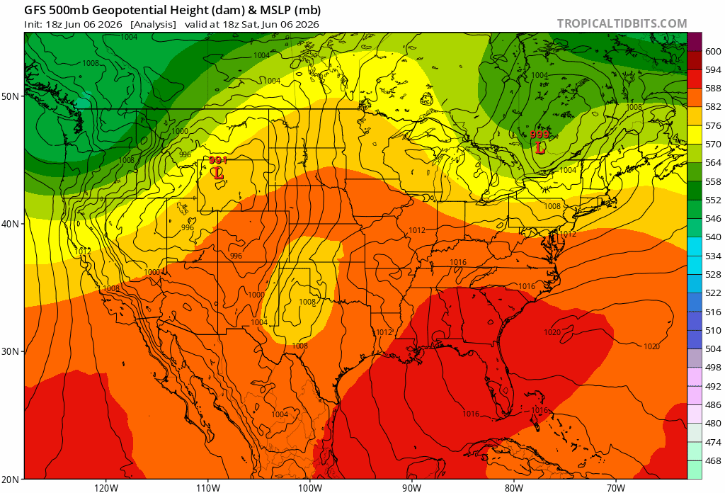
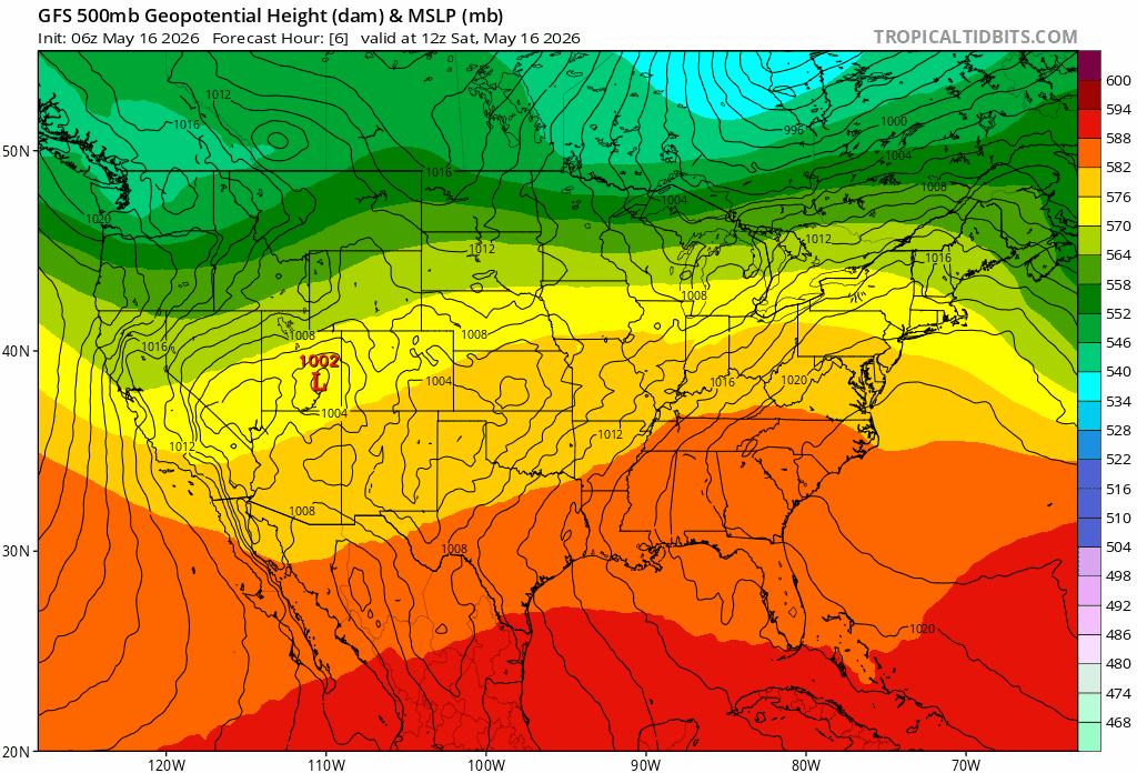
A back door cold front is moving through the northeast, bringing short relief from the heat, but a ridge of high pressure in the north central US is giving way to severe weather expected to move across the northern US. Temperatures in the 80s and 90s are expected until the weekend, as a large area of low pressure follows the severe weather, bringing highs in the 60s to 70s for the East, and potentially into the 50s in the Central US.
A High pressure ridge over the Central US gives way to severe weather, followed by lower pressure over much of the northern US. Loop provided by Tropical Tidbits
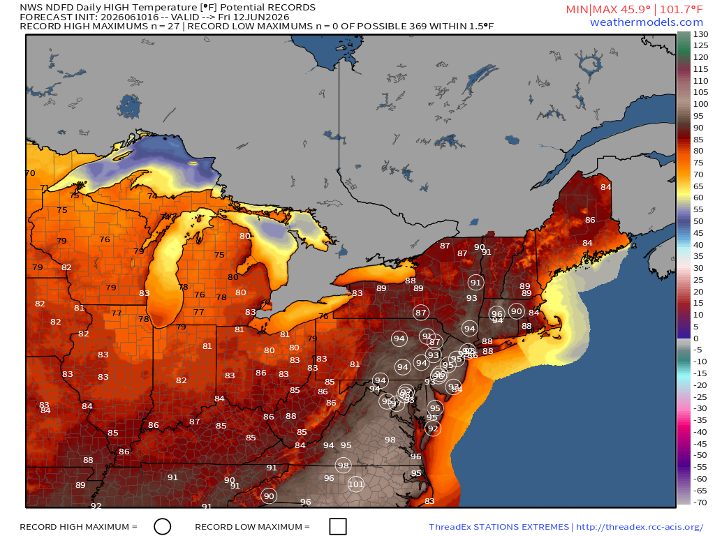
The warmest weather is expected on Thursday and Friday, as the high pressure sets up offshore, bringing warm humid air up the coast. Records could be set once again along the I-95 corridor, with temperatures well into the 90s, potentially reaching triple digits in North Carolina. Water temperatures along the coast have warmed up, with temperatures in the 50s and 60s along New England and into the 80s along the Southeast and Gulf Coast, providing some relief for people heading to the beaches. Cool temperatures should return over the weekend as a cold front moves through the region.
Record highs are expected through eastern US on Friday as a high pressure ridge sets up off the coast. Image provided by Weathermodels.com
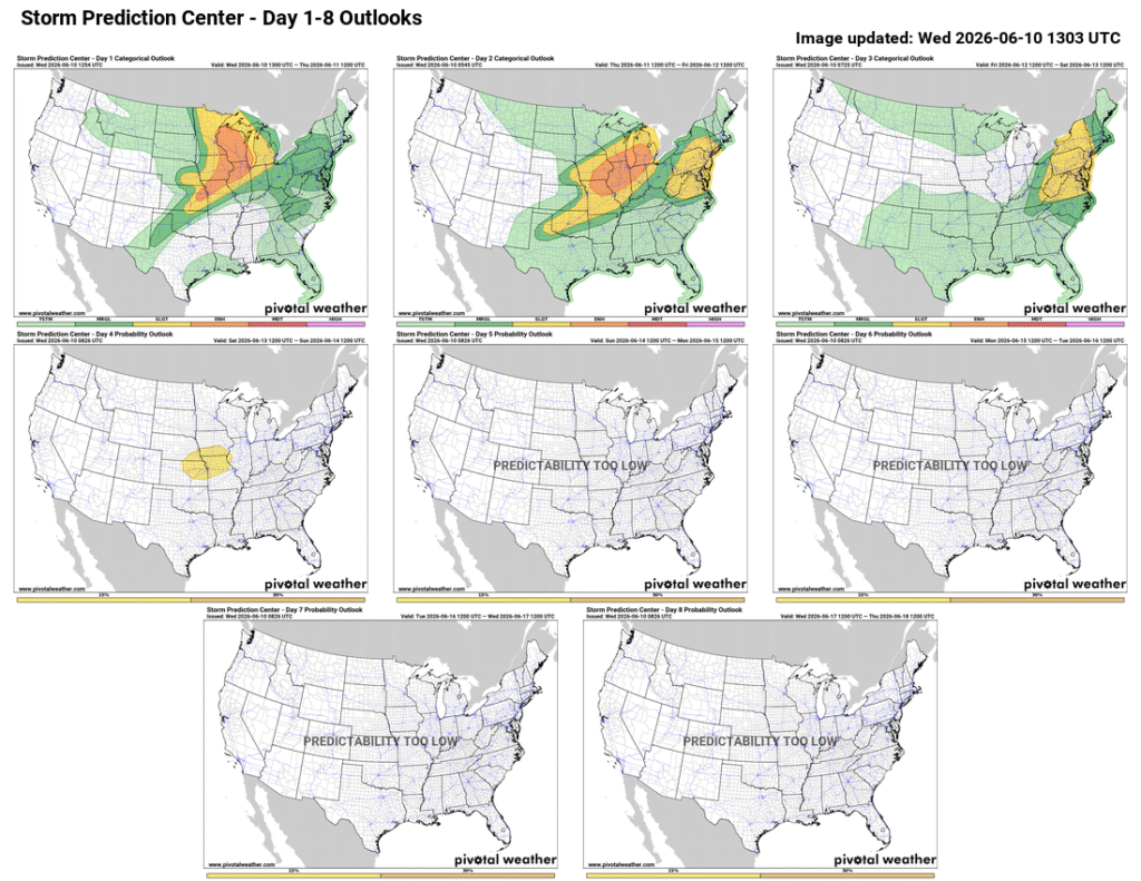
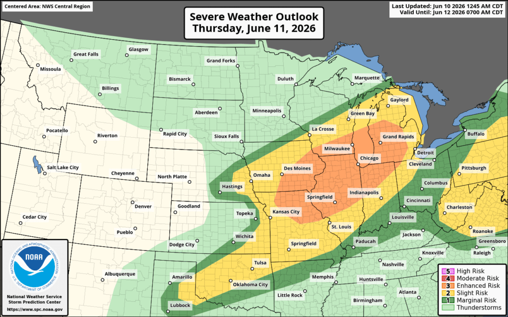
While the Eastern US can expect severe weather on Thursday and Friday, most of the Midwest is looking at severe weather continuing into Thursday.
Severe weather is likely to continue in the Central US Wednesday and Thursday, with the East Coast expecting some on Thursday and Friday. Image provided by Pivotal Weather
A low pressure trough pushing through a high pressure ridge promoted development of severe weather Tuesday night, which is expected to continue into Wednesday night and Thursday. Strong to severe thunderstorms are likely from the Central Plains northeastward into the Great Lakes, with an area developing along the East Coast on Thursday. Today, much of the Midwest can expect severe weather to continue, bringing strong winds, hail, and potentially tornadoes to the region, with a stronger wind threat Thursday, alongside continued hail and tornado risks.
The North Central Plains and Upper Midwest are looking at several rounds of storms tonight into Thursday. Image provided by NOAA.
As the system moves through, high pressure builds in behind it, bringing cooler temperatures and calmer weather. The East Coast can expect cooler weather on the weekend as the high makes its way to the region.
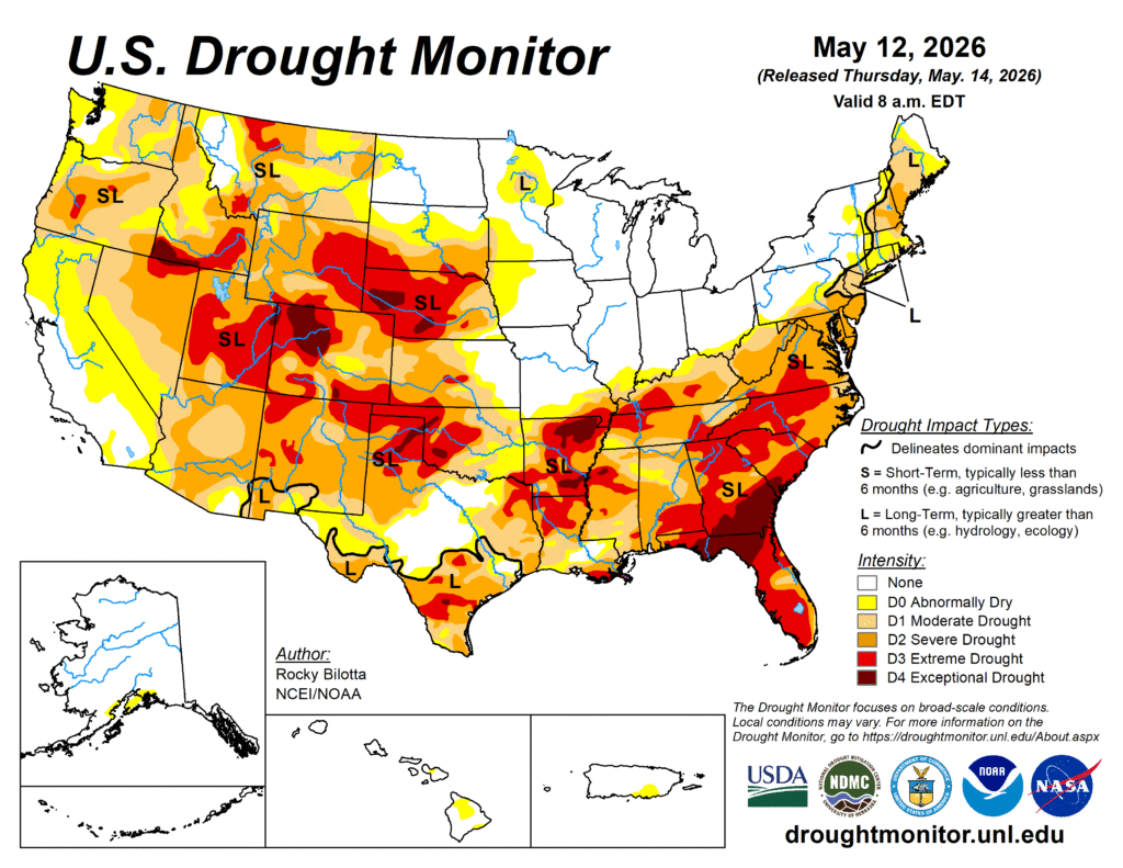
There’s an old saying in meteorology that goes “Droughts end in Floods”. That is likely to be the case over the next few days, as an extensive, and in some cases significant drought currently grips a large portion of the nation, but relief is on the way for some areas.
Drought conditions continue across a large portion of the nation. Image provided by the National Drought Mitigation Center.
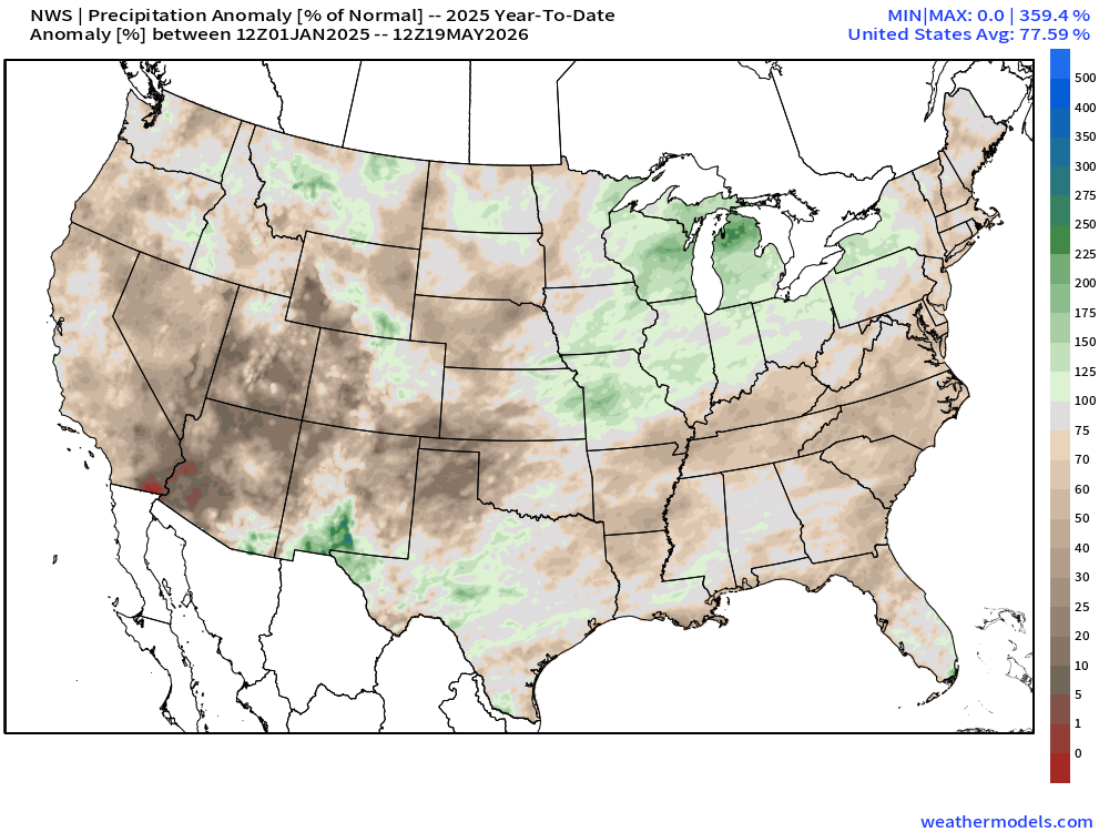
As is typical with a La Nina pattern that had been in place since last summer, dry weather was common for much of the southern tier of states over the past several months. Many locations from eastern Texas to the Southeast and up the East Coast are running precipitation deficits on the order of 6 to 12 inches or more over the past 6 months. This has worsened drought conditions in many areas, and created them in spots that weren’t that dry to begin with. That dry pattern is about to change.
Rainfall totals are well below normal across much of the South and the East this year. Image provided by weathermodels.com
A strong cold front extends from the Great Lakes to Texas this evening, and while the northern portion of the front will head eastward tonight and Wednesday, southern portions of the front will become stationary from Texas to the Carolinas over the next few days. With a southerly flow south and east of the front, moisture from the Gulf of Mexico will continue to flow northward, resulting in numerous episodes of showers and thunderstorms over the next several days from Texas to the Southeast.
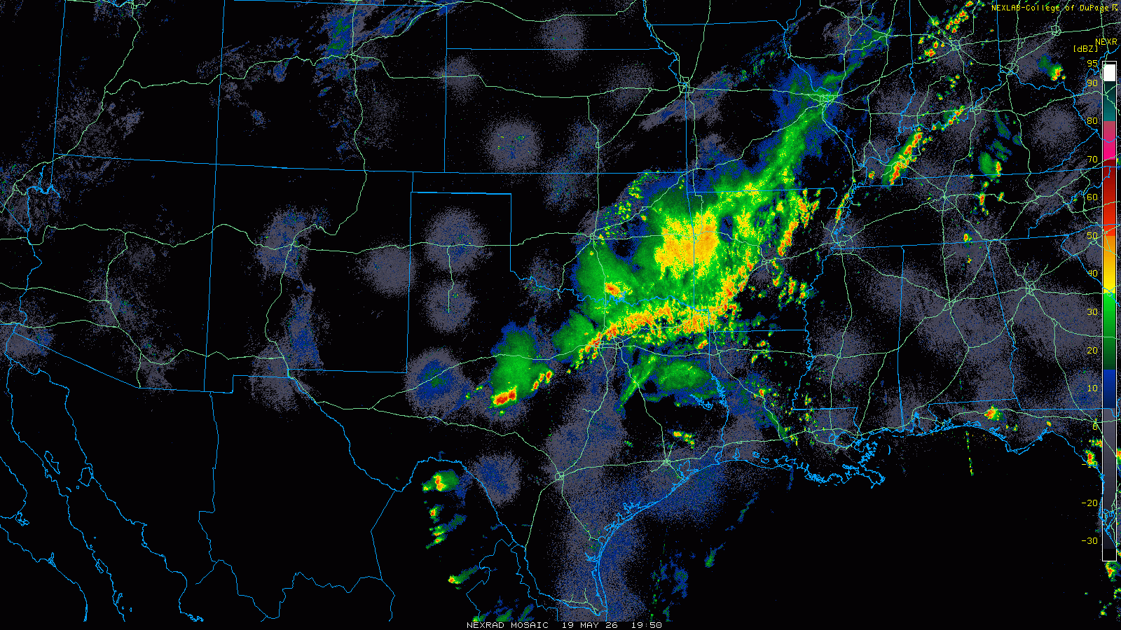
Strong to severe thunderstorms are ongoing late this afternoon from Texas to the Ohio Valley. Loop provided by the College of DuPage. (Click for loop)
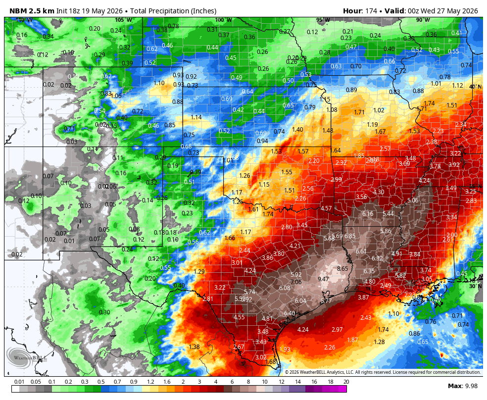
Strong to severe thunderstorms are already occurring across parts of Texas, and they will spread across much of the remainder of the Lone Star State this evening. With that front stalled out across central portions of the state for the next few days, waves of low pressure will ride along it, resulting in numerous episodes of heavy rain and thunderstorms. While severe weather is still possible along the tail end of the front in west Texas on Wednesday, heavy rain will be the main threat for the next several days. Between now and next Tuesday, much of southern and eastern Texas as well as nearby portions of Louisiana, Arkansas, and Mississippi could see as much as 4 to 8 inches of rain, with isolated totals to 10 inches or more possible. While this will wipe out the precipitation deficits, it will also result in flooding in many areas, especially urban areas like Houston where flash flooding is common during heavy rainfall.
Very heavy rain is likely across portions of Texas and the Lower Mississippi Valley over the next week. Image provided by WeatherBell.
Farther east, drought conditions remain very problematic across parts of the Southeast, where wildfires have been a problem this Spring. While some rainfall will move in over the next few days, the bulk of the heavy rain will stay north of this area, with the front remaining stationary across the Tennessee Valley and the Carolinas. In these spots, rainfall will still be significant, on the order of 1-3 inches and locally heavier, over the next several days, but nowhere near what will fall across Texas and the Lower Mississippi Valley. Drought conditions persist in this region as well, so the rainfall will be welcome.
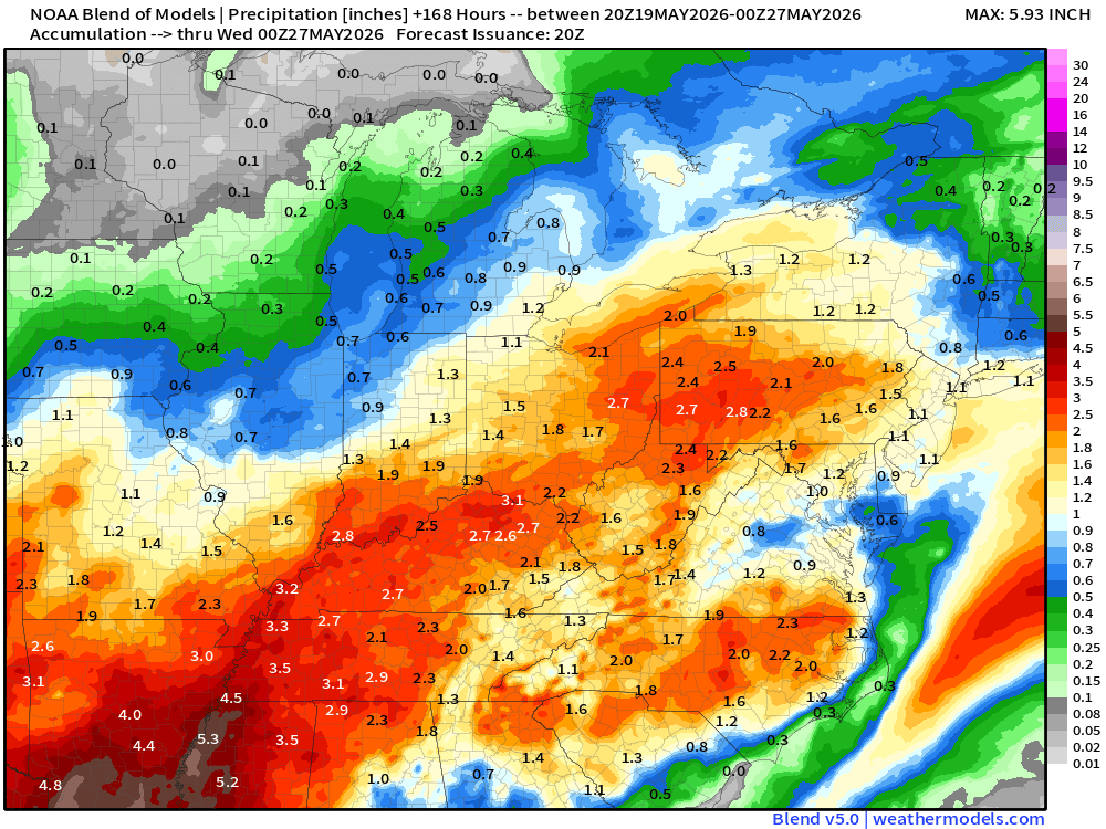
Several rounds of thunderstorms and heavy rain are likely from the Tennessee and Ohio Valleys to the Carolinas and parts of the East Coast this week. Image provided by weathermodels.com
Heavy rainfall is also likely across parts of the Ohio Valley, likely resulting in flooding in some spots. This are has received persistent rainfall through the Spring, so drought it not an issue, and the heavy rain falling on ground that is already saturated, or near saturation will end up in flooding. Many rivers in the region are already near flood stage, especially across southern Indiana and southern Illinois, so the addition rain will send these rivers over their banks.
Much of the Spring has featured an upper-level trough of low pressure across the Northeast, but that will change this weekend.
Temperatures have been below normal across most of the Northeast since mid-April. Image provided by the Northeast Regional Climate Center.
A persistent trough of low pressure has kept temperatures below normal across the Northeast for much of the past several weeks, but a ridge of high pressure will build in this weekend, both at the surface and aloft, resulting in some much warmer weather. Temperatures will get well into the 70s and 80s this weekend, with some spots topping 90. A weak backdoor cold front will bring cooler weather to parts of New England Sunday night and Monday, with temperatures only in the 60s and lower 70s, especially near the coastline, but inland areas, especially outside of New England, should get well into the 80s and lower 90s.
A ridge of high pressure will build into the East over the next few days. Loop provided by Tropical Tidbits.
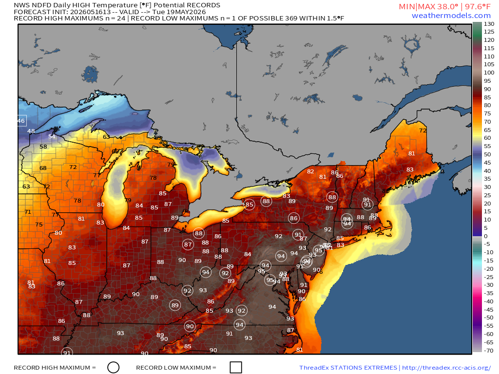
The warmest weather is expected Tuesday and Wednesday with high pressure anchored offshore. Southwest winds will bring warm and increasingly humid air to much of the East Coast, with high temperatures well into the 80s and 90s, likely setting records in many locations along the Interstate-95 corridor. Anyone heading to the beach for relief should remember that the water is still relatively cold as it is early in the season. Water temperatures are only in the 40s and 50s off the coast of New England, and 50s and 60s off the Mid-Atlantic coastline. A strong cold front will bring an end to the heat later Wednesday, possibly with some strong to severe thunderstorms accompanying that front.
Record highs are possibly in many locations in the Northeast Monday through Wednesday. Image provided by Weathermodels.com
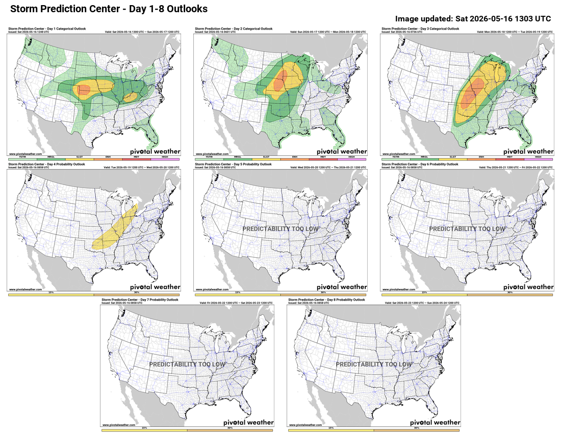
While areas in the East Coast are looking at the potential for severe weather on Wednesday, many spots in the Plains states and Midwest could see several waves of severe weather over the next few days.
A multi-day severe weather event is likely across the nation’s mid-section. Image provided by Pivotal Weather.
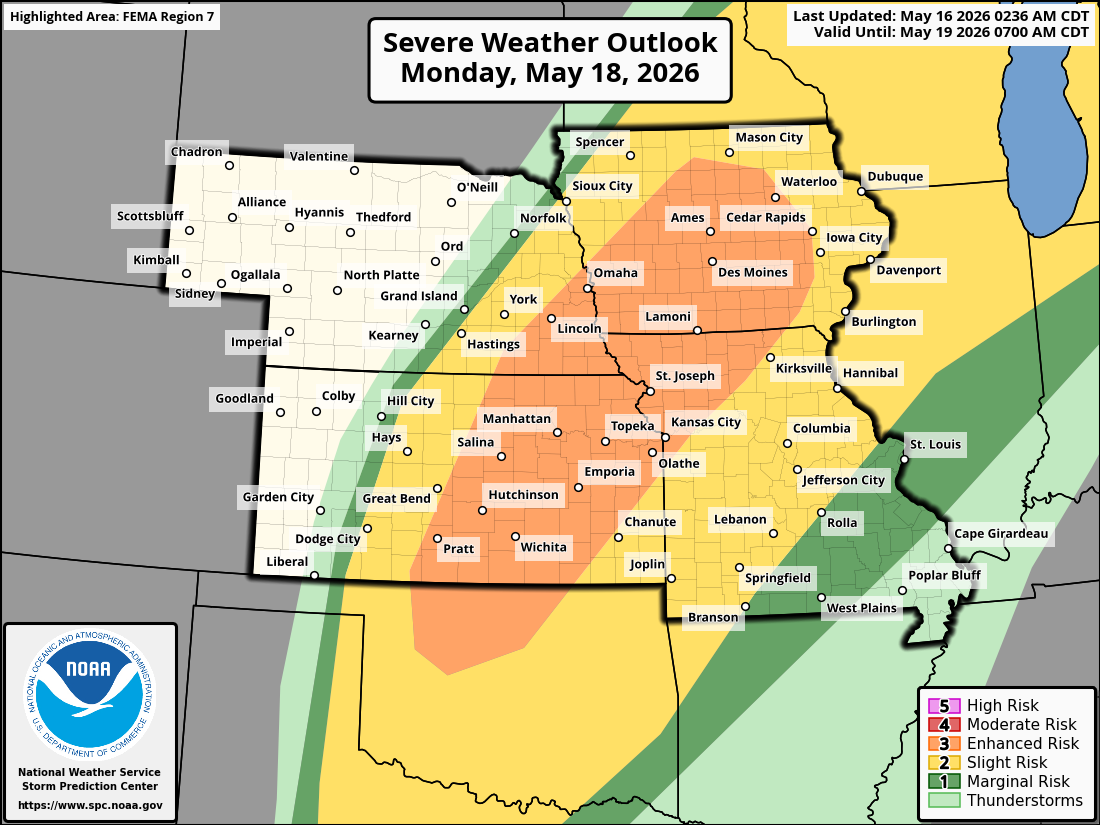
Low pressure developing in the southwestern Plains states will only slowly move northeastward over the next few days. Strong to severe thunderstorms are likely this afternoon and evening from the Central Plains eastward into parts of the Mississippi and Ohio Valleys. Areas from eastern Colorado across Kansas and Nebraska and into Iowa are under the gun today, with some of the stronger storms likely producing damaging winds, large hail, heavy downpours, and tornadoes. As the system slowly moves out of the Plains states and toward the Upper Mississippi Valley on Sunday, the focus of severe weather will shift into parts of the Northern and Central Plains and Upper Midwest, especially from Nebraska into Iowa and parts of Minnesota. Once again, storms may produce strong winds, large hail, heavy downpours, and tornadoes.
The Central Plains will be under the gun for multiple rounds of severe weather over the next few days. Images provided by the Storm Prediction Center.
By Monday, as the system moves into the Great Lakes and drags a strong cold front behind it across the Plains states, a very active day is expected from northern Texas northeastward to Michigan. Widespread strong to severe thunderstorms are likely, but the area from northern Oklahoma to Iowa is where the strongest storms are expected, with many supercells producing large hail, damaging winds, and numerous tornadoes. As the front moves eastward the threat for severe weather on Tuesday will shift to parts of the Great Lakes and Ohio Valley, as well as the southern Plains, and then potentially to parts of the East Coast and Tennessee Valley on Wednesday.
Drought conditions continue across a large portion of the nation. Image provided by the National Drought Mitigation Center.
There is a bit of a silver lining to this, as widespread rainfall, some of it heavy, is likely across a large portion of the nation’s mid-section. Much of this region, especially the Central and Southern Plains, is in the middle of a significant drought, so any rain is beneficial, and will help put a dent in the drought, especially as the growing season gets underway.
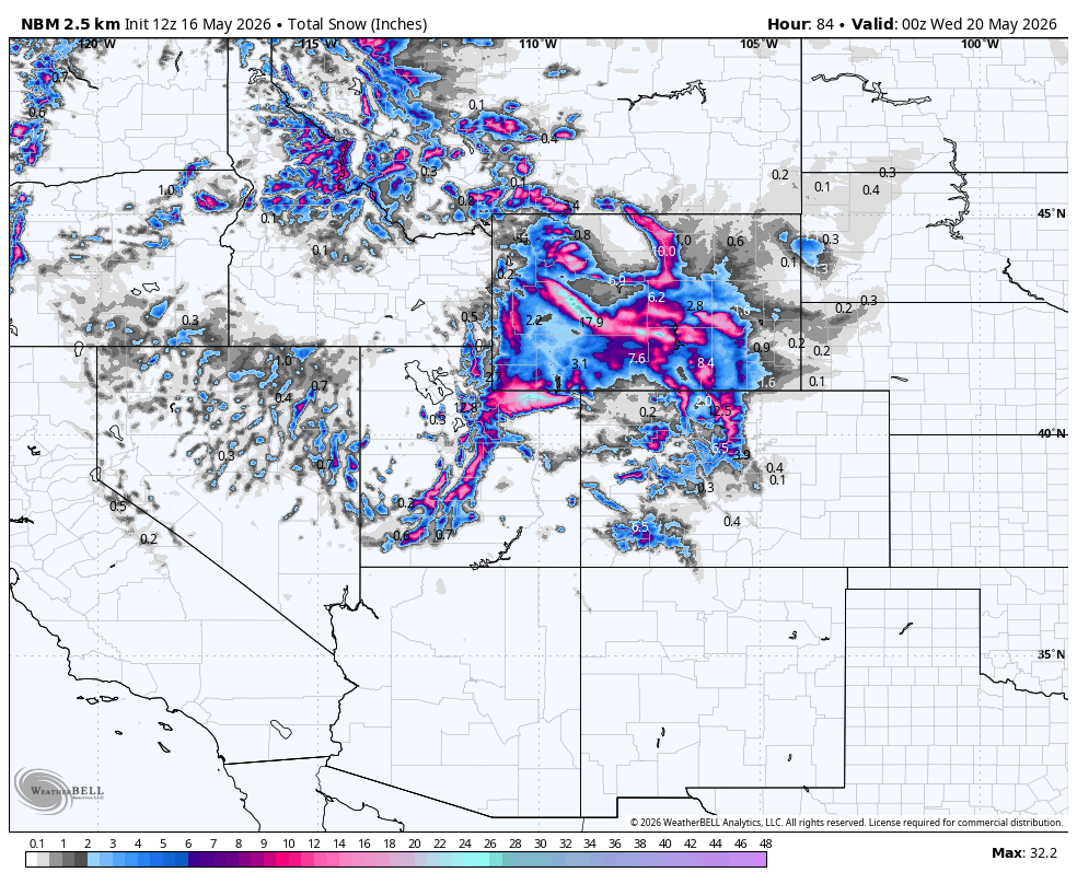
Another late-season snowstorm is possible across parts of the Intermountain West and the Rockies late this weekend and early next week. Image provided by WeatherBell.
Behind the cold front, much colder air will settle into the Plains states and the Rockies. Some record lows are possible both Monday and Tuesday morning as temperatures drop into the 20s and 30s. At the same time, another low pressure system will be moving across the Great Basin, and as it encounters the colder airmass, snow is expected across the mountains, with much-needed rain at the lower elevations. Winter Storm Watches have already been issued for parts of Wyoming for late Sunday and Monday, and more are likely to be issued for parts of the region, including Utah and Colorado, later today. Some of the mountains could pick up as much as 1-2 feet of snow, possibly even more in spots. Some flakes could mix in with the rain in the Denver area Monday and Monday night, with accumulations likely in the foothills west of the city. After a fairly dry winter, the snow is welcome, as it will help with spring runoff.
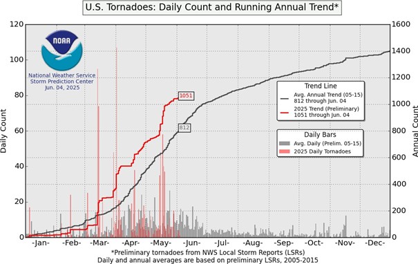
The United States is notorious for its crazy weather, especially during the spring. There are dozens of tornado outbreaks yearly, especially through the Midwestern region, otherwise known as Tornado Alley. As of June 4th, more than 1,000 tornadoes have been reported to the Storm Prediction Center. One significant outbreak of this year occurred between May 15th and 16th.
So far in 2025, 1051 tornadoes have been reported, more than 200 over the average. Image provided by the Storm Prediction Center.
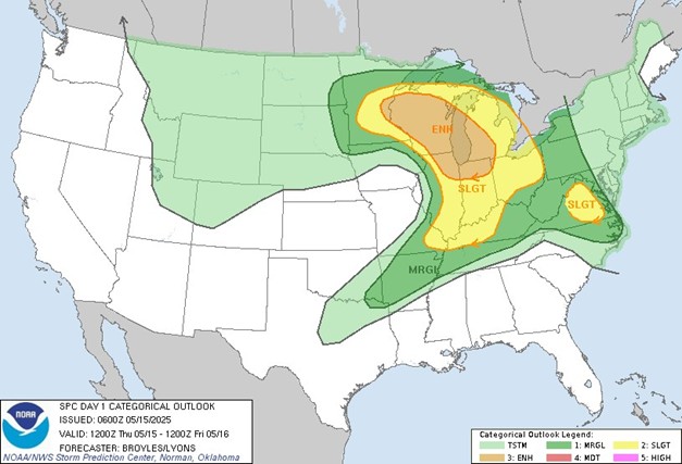
On May 15th, a low-pressure system was developing in the Central Plains, with two fronts extending from this system: a warm front moving from the Ohio Valley to the Great Lakes and a cold front moving into the Mississippi Valley from the Central Plains. The moderate instability between these fronts led the Storm Prediction Center to issue an outlook with an enhanced risk for severe weather for eastern Minnesota, central Wisconsin, Lake Michigan, northern Indiana, and northeastern Illinois.
On May 15, a large portion of the Upper Great Lakes was at an enhanced risk of severe weather. Image provided by the Storm Prediction Center.
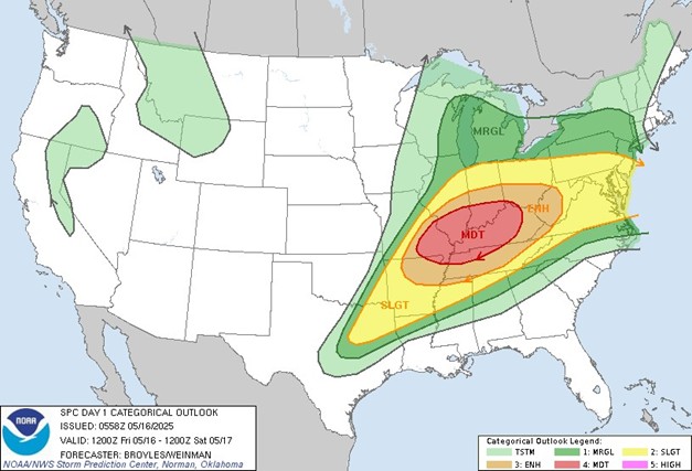
The severe weather threat continued the following day as the system moved from the Northern Plains into the Upper Mississippi Valley with the area of instability over the Ohio and Tennessee Valleys. The Storm Prediction Center issued an outlook with an enhanced risk of severe weather for most of the Ohio and Tennessee Valleys and eastern areas of the Lower Mississippi Valley, along with a moderate risk for much of Kentucky, northwestern Tennessee, southeastern Missouri, southern Illinois and Indiana.
A Severe Weather Outbreak was expected across parts of the Ohio and Tennessee Valleys on May 16. Image provided by the Storm Prediction Center.
By the end of this outbreak, 56 confirmed tornadoes had occurred, including three EF-3 and two EF-4 tornadoes. Unfortunately, 27 confirmed fatalities and more than 60 reported injuries were reported. The longest and deadliest tornado occurred near the end of the outbreak in Eastern Kentucky.
At 10:27 pm EDT on May 16th, the tornado touched down northeast of Jamestown, Kentucky, located in Russell County, and near Kentucky State Route 619. According to the NWS, the tornado may have briefly lifted for a few hundred yards due to the sporadic damage near the initial touchdown point. The tornado continued east as it intensified, crossing through several communities and leaving high-end EF-1 to EF-2 damage in its wake before crossing into Pulaski County. Here, it caused significant damage, especially in the towns of Fabush and Nancy, before continuing east into Somerset. In this community, the tornado gained enough strength to be rated an EF-3. With this strength, it continued toward the Daniel Boone National Forest, and satellite imagery across this region showed that the tornado was almost a mile wide. As the tornado exited the National Forest, it moved into the south side of London, where it continued strengthening. This densely populated area was where the heaviest damage and most casualties occurred. The tornado crossed through the Sunshine Hills subdivision, causing several homes to be removed from their foundations. Surveyors in this area had agreed that at this time, the tornado had once again gained enough strength to increase its rating to an EF-4, with up to 170 miles per hour wind speeds. The tornado continued toward the London-Corbin Airport, losing strength and being downgraded to an EF-3. Beyond the airport, where several aircraft and hangars were damaged and destroyed, it lost significant strength while still leaving a path of destruction at the Crooked Creek Golf Course, Laurel County Fairgrounds, and neighboring subdivisions. The tornado finally lifted off the ground just before midnight EDT, leaving a nearly 60-mile path of destruction, with 19 fatalities.