M is for Mayhem

For the third year in a row, the “M” storm in the Atlantic is prepared to wreak havoc on a populated area, but Michael isn’t the only headline maker in the weather at the moment.

Hurricane Michael isn’t the only storm in the news, but it is the biggest threat at the moment. As of early Tuesday afternoon, Michael was centered about 335 miles south of Panama City, Florida, moving toward the north at 12 mph. Maximum sustained winds are near 110 mph, making Michael a Category 2 Hurricane. Additional strengthening is expected over the next 12-18 hours as the storm moves over the warm waters of the eastern Gulf of Mexico. Hurricane and Storm Surge Warnings are in effect for the Florida Panhandle and the Big Bend area of Florida, with Tropical Storm Warnings and Watches surrounding the Hurricane Warnings. Tropical Storm Watches are also in effect for the Atlantic coast from northeastern Florida into South Carolina.

Forecast track for Hurricane Michael. Image provided by the National Hurricane Center.

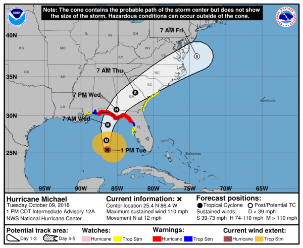
Michael is expected to make landfall in the Florida Panhandle Wednesday afternoon, likely as a Category 3 storm. Strong winds, torrential rainfall, storm surge, and some tornadoes are all possible with this storm. Unlike Florence, which hung around the Carolinas for days and dumped incredible amounts of rainfall on the region, Michael is expected to keep moving at a steady pace, emerging off the Mid-Atlantic coast by Friday morning. Rainfall totals of 5-10 inches are still expected in parts of the region, which will produce flooding in some areas, especially in Carolinas, where many areas are still recovering from Florence. Right along the coast, a storm surge of 6-12 feet is possible, especially in the Big Bend area of Florida. Fortunately, this area is not heavily populated, but for the residents that do live in this area, storm surge flooding is a significant threat.

This is the 3rd year in a row that the “M” storm is expected to result in significant damage to a populated area. In 2014, Category 5 Hurricane Matthew left a path of death and destruction across parts of Haiti, Cuba, the Bahamas, and eventually parts of the southeastern United States. Last year, Category 5 Hurricane Maria devastated the northeastern Caribbean, including Puerto Rico and the US Virgin Islands. While Michael is not expected to become a Category 5 storm, it is still expected to result in significant damage to parts of Florida and the Southeast.

Satellite loop of Tropical Storm Leslie. Loop provided by NOAA.

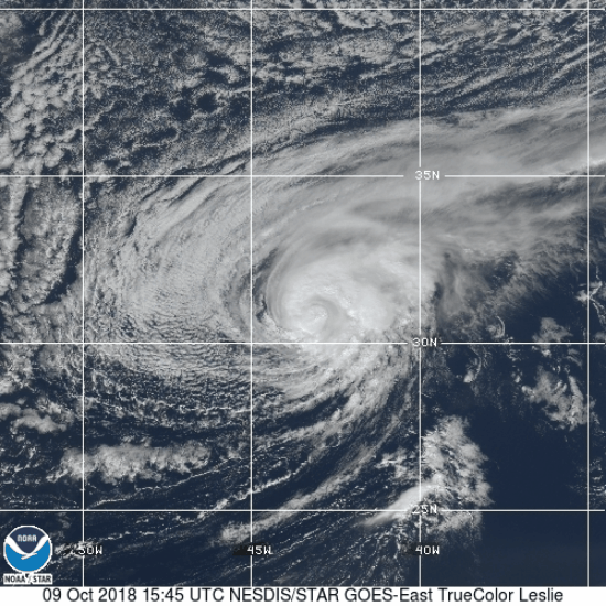
Meanwhile, in the eastern Atlantic, Tropical Storm Leslie refuses to go away. As of midday Tuesday, Leslie was centered a little more than 1000 miles west-southwest of the Azores, moving toward the south-southeast at 13 mph. Maximum sustained winds are near 65 mph. The forecast for Leslie calls for a turn more toward the east over the next few days while it strengthens back into a hurricane. Leslie is expected to remain over open waters for the next few days, and could become an extratropical storm this weekend while continuing on a general easterly track.

To the south, Tropical Storm Nadine as formed nearly 500 miles southwest of the Cabo Verde Islands. Nadine has maximum sustained winds near 40 mph, and is moving toward the west-northwest at 9 mph. Nadine is expected to remain fairly weak over open waters for the next several days while turning more toward the northwest. As it moves over colder water late this week and this weekend, it should weaken and eventually dissipate.

Back in the United States, unseasonably warm conditions remain in place across much of the eastern half of the nation. Temperatures are in the 70s and 80s across much of the region, which is 15 to 25 degrees above normal. A strong frontal system is located in the Plains states this afternoon, separating the warm air in the East, from much cooler weather behind it in the Plains and the Rockies. Right along this front, which hasn’t moved much for the past 24 hours, severe weather and heavy rainfall are common this afternoon.

National radar loop from early Tuesday afternoon. Loop provided by Weathertap.

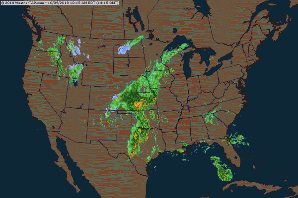
Several tornadoes have been reported already today, including a few in the Oklahoma City area, and more are expected later today and tonight. Heavy rainfall is also expected from Texas into the Central Plains and parts of the Upper Midwest. Rainfall totals of 1-3 inches and locally heavier may produce flash flooding in some areas. Flash flood watches are in effect for much of the region.

Snowfall forecast through Thursday morning from the WRF model. Image provided by Pivotal Weather.

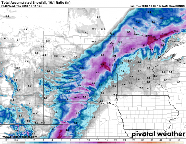
On the other side of the front, where much cooler weather is in place, rain is expected to change over to snow as low pressure rides along the front and into the Midwest. Winter weather advisories have already been posted for parts of the region. Snow is already falling in parts of Colorado this afternoon, and several inches may fall over the next 36-48 hours from western portions of Kansas and Nebraska into the Dakotas and northern Minnesota.

Hot in Texas, Humid in the East, Severe Weather in the Midwest

The “Dog Days of Summer” have arrived, with heat and humidity across a large part of the nation. Meanwhile, severe weather is possible across the Midwest on Friday.

A weather pattern that is both typical and atypical of summer at the same time is going to settle into the nation over the next several days. The typical part is that we’ll have a ridge of high pressure off the East Coast, and another one in the Southwest. The ridge off the East Coast will result in heat and humidity up and down the coastline for the next several days. The ridge in the Southwest will bring very hot conditions to the Southwest and especially the Southern Plains, where record highs are expected over the next several days. The Atypical part is across the Midwest. Normally, in between the two ridges of high pressure you’d have a trough of low pressure, but in this case, we actually have a closed upper-level low pressure system. While these are common in the fall, winter, and spring, they usually don’t occur much in the summer. This will bring cooler than normal conditions into the Midwest for the next few days.

The upper-level pattern features ridges of high pressure in the Southwest and off the East Coast, and an upper-level low pressure system in the Great Lakes. Image provided by Pivotal Weather.

While hot weather is expected across Texas and the Southwest during the summer, the ridge of high pressure that is currently setting up across the region will bring in temperatures that are well above normal. In fact, record highs are expected for the next several days across much of Texas, as temperatures soar past 100 across much of the state, with some locations possibly exceeding 110 degrees. The heat won’t be confined to the Lone Star State, with triple-digit highs also expected from parts of the Lower Mississippi Valley into the Southern Plains as well as parts of Colorado and New Mexico. There won’t be much, if any, relief at night either, as low temperatures will stay in the 70s, with many locations, especially urban areas like the Dallas-Fort Worth Metroplex likely not dropping below 80 degrees for low temperatures.

Friday looks to be the hottest day across the Southern Plains and Texas, with many record highs expected to be broken. Image provided by WeatherModels.com

As we head into next week, the heat will ease a bit across Texas and the Southern Plains, but the core of the intense heat will shift westward into the Desert Southwest. High temperatures will top 110 degrees across much of the area for the first half of next week, with the usual hot spots such as Lake Havasu City, Arizona; Laughlin, Nevada; and Death Valley, California likely exceed 120 degrees during some of the afternoons. Highs will also top 100 across much of interior California once again.

Moisture will stream northward from the tropics into much of the East Coast over the next several days. Loop provided by WeatherModels.com

While the Texas and the Southwest deal with extreme heat, the East Coast will get a little bit of relief from what has been a hot start to summer. While temperatures will still be a little above normal this weekend into much of next week, highs will only be in the 80s to lower 90s. While the temperatures won’t be that bad, humidity levels will. With high pressure anchored off the East Coast, a southerly flow will help moisture stream northward from the tropics right up the East Coast this weekend and into much of next week. Dewpoints will be in the upper 60s and 70s across the region, so even though temperatures may not be hot, it will feel oppressive across much of the region.

Heavy showers and thunderstorms are expected across much of the East Coast each afternoon over the next week. Image provided by College of DuPage.

With a warm and humid airmass in place for much of the week, it won’t take much for showers and thunderstorms to develop each day. With plenty of available moisture, some of these storms will end up producing very heavy rainfall. While the map above is a forecast that shows widespread coverage of heavy rain, in many cases, the storms will be very localized. Some locations could get hit by slow-moving thunderstorms over and over, while other spots a few miles away get little to no rainfall. Across the Mid-Atlantic States, where heavy rain led to flooding during the Spring, similar conditions are possible again for the next week. Across the Northeast, things are a little different.

Much of the Spring has been very dry across New England and New York, with drought conditions developing. Image provided by the National Drought Monitor.

Much of the Spring has been very dry across New England and New York. Localized thunderstorms have brought heavy rain to a few spots, especially earlier this week, but overall, rainfall has been well below normal across the area. Some relief will come this weekend. A weak low pressure system will move across the region late Saturday into Sunday as an upper-level low pressure system moves into the Midwest. The surface low will bring heavy rain and some gusty winds to parts of Southern New England and southeastern New York. The heaviest rain is expected late Saturday night into early Sunday morning, so neither day should be a washout. Once that system moves by, a warm and humid airmass will settle in, with a daily chance for showers and thunderstorms this week.

This pattern is expected to remain in place through at least next weekend and possibly even longer. While none of the models are showing development of any systems in the tropics right now, this is the type of pattern that is conducive to storms impacting the East Coast. The tropics have been fairly quiet so far this season, and a relatively quiet season is expected, especially compared to last year. However, should something develop in or near the Bahamas, it wouldn’t take much for it to impact the East Coast with relatively little lead time. In 1991, a tropical depression developed in the Bahamas on August 16, 48 hours later it was a Category 3 Hurricane named Bob brushing the Outer Banks of North Carolina before slamming into Southern New England as a Category 2 storm 12 hours after that.

A severe weather outbreak is possible on Friday across the Ohio and Tennessee Valleys. Image provided by the Storm Prediction Center.

While Texas bakes and the East Coast sweats, an upper-level low pressure area will settle into the Midwest. With the clash in airmasses along a cold front, showers and thunderstorms will develop. Some of these storms will become strong to severe on Friday, especially across the Ohio and Tennessee Valleys. The main threats with any storms that develop will be strong winds, large hail, and torrential rainfall that could trigger flash flooding. Some tornadoes are also possible. The storms may start during the morning closer to the Great Lakes, with the afternoon and evening seeing the most widespread activity across the region. While activity should weaken at night, the threat of severe weather will continue across southern and eastern parts of the region.

Strong to severe thunderstorms are expected across the Midwest on Friday. Loop provided by WeatherModels.com


Here Comes the Heat

As we get into the final days of June and prepare to flip the calendar to July, a heat wave is about to grip a large portion of the nation.

Heat and humidity are already in place across much of the nation’s mid-section. Excessive Heat Warnings and Heat Advisories are in effect across the eastern Plains and much of the Mississippi Valley on Friday. High temperatures will be in the 90s and lower 100s across the region. When you add in dewpoints in the 60s and 70s, heat indices will range from 100-115 degrees across much of the area during the afternoon.

Heat indices will exceed 100 degrees across much of the nation’s mid-section on Friday. Image provided by WeatherBell.

The heat will spread to the East Coast today, with very hot conditions expected for Sunday and Monday. High temperatures will soar well into the 90s across much of the East, with dewpoints slowly creeping up over the next few days. Right now, Sunday looks like the hottest day, with temperatures reaching the middle to upper 90s across the heavily-populated I-95 corridor. Relief will be found right along the coastline, where seabreezes may keep temperatures in the 80s.

Several record high temperatures could be broken across the Northeast on Sunday. Image provided by Weathermodels.com

Some changes start to happen towards late Monday and Tuesday. A cold front will start to approach the Northeast. This may produce a few showers and thunderstorms, especially across parts of New England, with some relief from the heat across Northern New England behind the front. There are questions as to how far south this front will get before it dissipates however. Odds are that it dissipates before reaching the New York City area, but if it washes out across central New England, then the heat will continue across southern New England right through the Fourth of July and possibly the end of the week. Across the Mid-Atlantic states, especially from New York City down to Washington, hot and humid conditions should continue for much of the week.

A ridge of high pressure will expand westward into the Plains and Rockies as we get towards the middle of the week. Image provided by Pivotal Weather.

The ridge of high pressure aloft responsible for the heat across the East will start to spread westward as we head towards the middle of the week. This will have several implications. In the East, it will allow the heat to begin to ease. With winds becoming more northwest aloft, disturbances will be able to drop down from Canada, bringing in some much needed shower and thunderstorm activity, along with some slightly cooler conditions. This will also allow the heat to spread back into the Mississippi Valley and the Plains states. High temperatures will be back into the 90s and lower 100s across the area as the ridge moves back into the area.

Back to top