Hurricane Dorian continues to blast Grand Bahama Island this afternoon, but elsewhere, the Atlantic is getting active quickly.
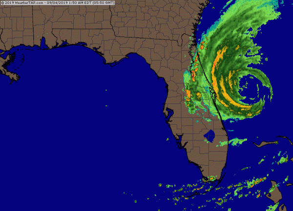
As of early Wednesday morning, Hurricane Dorian was centered about 80 miles east-northeast of Cape Canaveral, Florida. After sitting over the Bahamas for a couple of days, Dorian is now moving toward the north-northwest at 7 mph. After peaking as a Category 5 on Sunday, Dorian has weakened to a Category 2 hurricane this afternoon, with maximum sustained winds near 110 mph.
At it’s peak, Dorian had sustained winds of 185 mph, which is tied for the 2nd highest on record in the Atlantic Basin, and the highest for a storm that far north. Only Hurricane Allen in 1980 was stronger, with top winds near 190 mph. Dorian’s lowest pressure of 910mb, is tied for the 9th lowest on record in the Atlantic. It is the strongest hurricane ever to make landfall in the Bahamas.
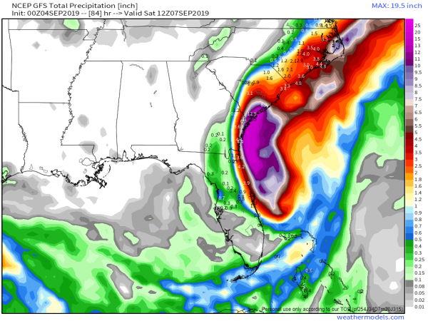
As for Dorian’s future, the thinking really hasn’t changed much in the past few days. The slow north-northwestward motion has started, and a turn more toward the north with some acceleration is expected today as a trough of low pressure approaches the East Coast. This should keep the center of the storm 75 miles or so off the Florida coastline. Dorian is expected to maintain its current intensity for the next day or two, but some minor re-strengthening is possible as the storm remains over very warm water and in an area of low wind shear. Likewise, it could weaken a bit as it is still fairly close to land. The outer bands of Dorian will continue to impact coastal Florida today, with bouts of heavy rain and gusty winds at times. A Hurricane Warning remains in effect from central Florida up into parts of North Carolina.
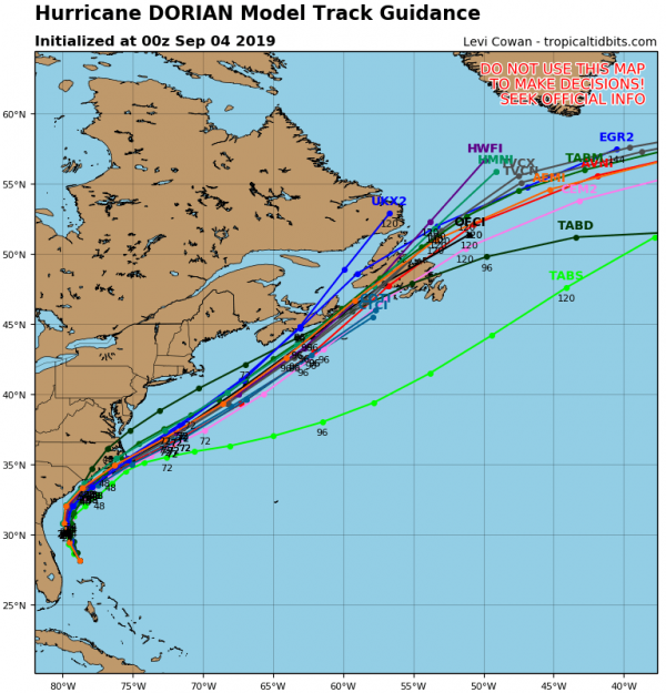
To the north, Dorian should start to turn northeastward later today into Thursday, coming very close to the coastline of both South and North Carolina. This will bring hurricane conditions to these states. As previously mentioned, Hurricane Warnings are in effect for parts of the area, with a Hurricane Watch in effect from Surf City, NC, to the NC/VA border. Although the official forecast from the National Hurricane Center keeps the center offshore, it will be close enough that even a slight wobble to the left could result in landfall. Whether it makes landfall or not, strong winds, torrential rainfall and very rough surf are expected in these areas over the next couple of days.
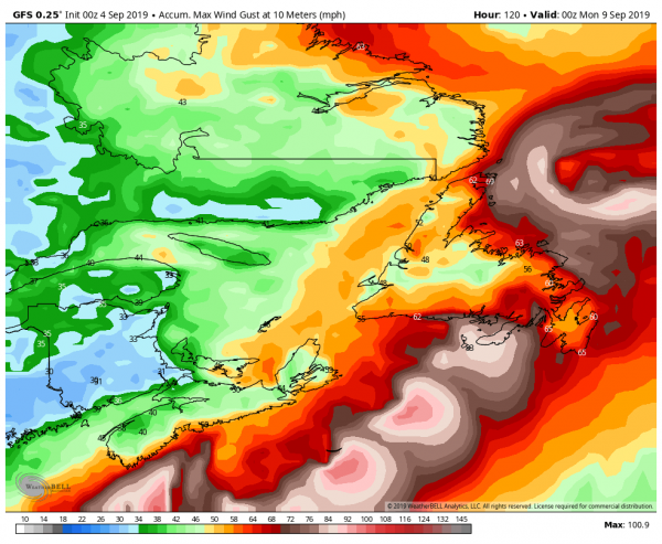
Once past the Carolinas, Dorian should continue northeast, and start to transition into an extratropical storm. That doesn’t mean that it’s done impacting land though. It could graze Cape Cod and the Islands with some rain and gusty winds late Friday into early Saturday, but over the weekend it will likely have a significant impact on Atlantic Canada. Heavy rain is likely across parts of Nova Scotia, New Brunswick, Prince Edward Island, and into Newfoundland. While some locations could pick up 2-4 inches of rain, the biggest impact will be from the wind. Sustained winds of 30-50 mph are expected with gusts of 60-70 mph or more, especially along the coastline. One other impact that you might not normally expect – across parts of Labrador and possibly northern Newfoundland, it will be cold enough for the rain to fall as snow, with several inches possible in parts of Labrador.
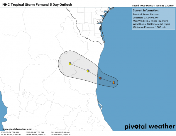
Dorian isn’t the only active storm in the Atlantic any more. Tropical Storm Fernand formed Tuesday afternoon in the Gulf of Mexico. As of early Wednesday morning, it was centered about 90 miles southeast of La Pesca, Mexico, moving toward the west at just 3 mph. It has maximum sustained winds near 50 mph, and it may strengthen a little more over before landfall in northeastern Mexico later today. A Tropical Storm Warning has been issues for parts of northeastern Mexico. The biggest impact from Fernand likely to be from heavy rainfall. Rainfall totals of 6-12 inches and locally heavier will produce flooding and mudslides across the area. Heavy rain is expected across parts of South Texas, where 2-4 inches may fall, resulting in some flash flooding.
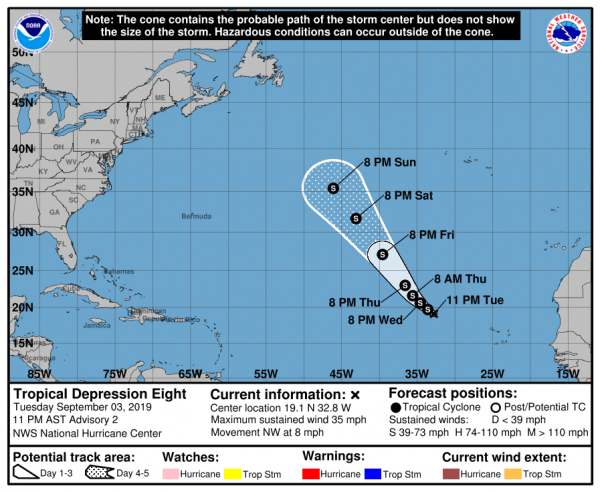
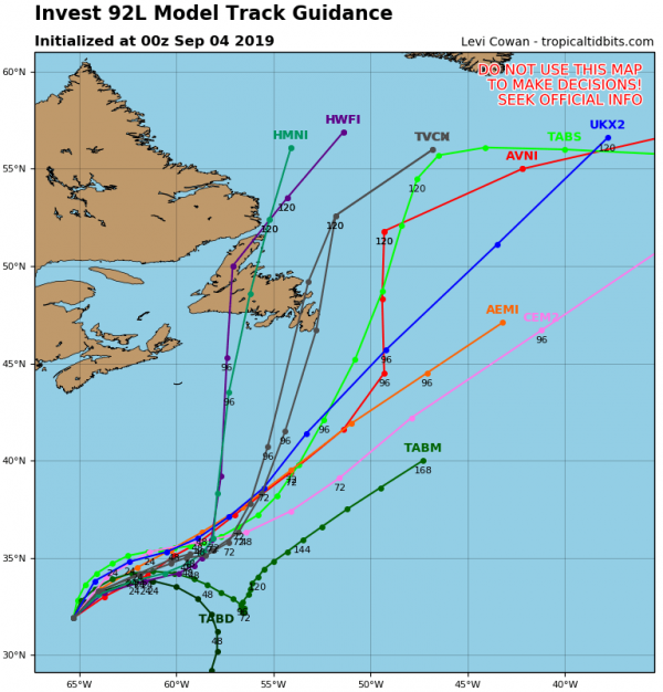
We’re not done yet, as Tropical Depression 8 formed Tuesday evening well out in the Atlantic. As of early Wednesday morning, the system was centered a little more than 600 miles west of the Cape Verde Islands, moving toward the northwest at 8 mph. It has maximum sustained winds near 35 mph, and will likely strengthen into a tropical storm later today. It is expected to continue on a northwest track for the next several days, staying over open water the entire time and presenting no threat to any land areas.
Yet another disturbance is located just northwest of Bermuda early this morning. It may bring some squally weather to Bermuda today before it pulls away from the area. Conditions are marginally favorable for development for the next day or two, but by late week, it will move into an area where development is unlikely.This system is not well-organized, and conditions aren’t very favorable for further development. It will be monitored over the next few days, and may bring some squally weather to Bermuda later this week.
If that’s not enough, there’s another wave still over western Africa that will move into the Atlantic later this week. Forecast models are showing the potential for that wave to develop as well. This shouldn’t be a big surprise, September is the peak of hurricane season.
This is just the Atlantic – we didn’t even get into the Pacific, where Hurricane Juliette is a Category 3 Hurricane southwest of Mexico, Typhoon Lingling is passing east of Japan on its way towards Korea, Tropical Storm 14W is expected to become a typhoon passing north of the Northern Mariana Islands on its way towards Japan, and Tropical Depression Kajiki is dissipating along the coast of Vietnam.