Hurricane Season looks to remain quiet across the Atlantic for the remainder of August, but it’s a different story in the Pacific, where there are three storms threatening land right now.
Hurricane Lane has been steadily moving across the Eastern and Central Pacific Ocean for the past week while strengthening. As of midday Monday. Lane was centered about 615 miles southeast of Hilo, Hawaii, moving towards the west at 14 mph. Lane’s maximum sustained winds peaked at 140 mph on Saturday, and have since dropped to 125 mph, meaning it is still a Category 3 Hurricane. It is expected to maintain its current intensity through Tuesday before a more pronounced weakening trend develops.
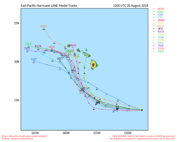
The forecast track for Lane is a bit problematic. Lane is expected to continue westward for another day or two before turning more towards the northwest or north. Where it makes that turn is very important, as it will determine what, if any, impact Lane may have on Hawaii. At the very least, we’re looking some rough surf and some gusty winds for parts of the island chain. However, a closer pass brings stronger winds and heavy rain in, especially to some of the northwestern islands.
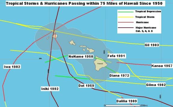
Hawaii doesn’t get direct hits from hurricanes very often. In fact, since their tropical cyclone records began in 1950, only 3 hurricanes have made direct hits on Hawaii – Hurricane Dot in 1959, Hurricane Iwa in 1982, and Hurricane Iniki in 1992 – all of which hit the island of Kauai . Dot and Iwa were both Category 1 storms when they hit, while Iniki was a Category 4 storm. There have been a lot more tropical storms that have hit the islands, and hurricanes that passed close enough to impact part of the island chain, but only those 3 have had direct impacts.
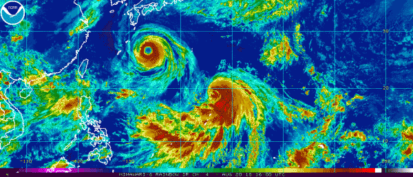
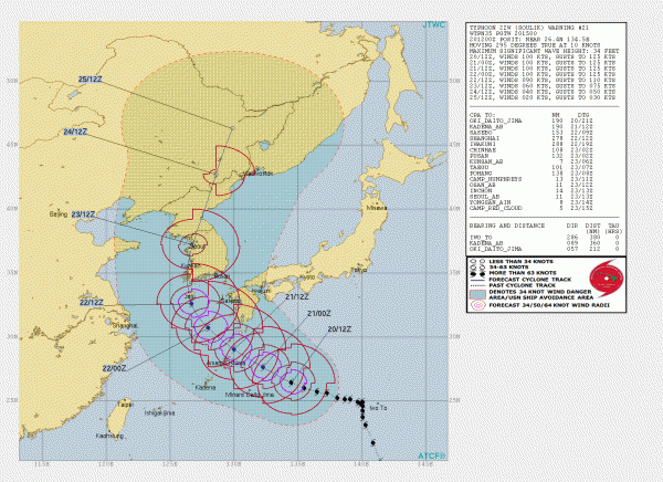
Heading much farther to the west, Typhoon Soulik is threatening parts of Japan and South Korea. As of midday Monday, Soulik was centered about 415 miles east of Okinawa, moving toward the west-northwest at 12 mph. Soulik has maximum sustained winds near 115 mph, and is expected to maintain that intensity for the next 24-36 hours. After that it should start to weaken a bit while turning more toward the northwest as it crosses the Ryukyu islands southwest of Japan. After that, a turn more towards the north and steady weakening are expected as Soulik heads for the coast of South Korea. If the storm makes the northerly turn a little later than currently anticipated, it could remain over the Yellow Sea a little longer, and make landfall in North Korea instead, likely in a somewhat weaker state. Either way, damaging winds heavy rainfall, and flooding are likely across the Korean Peninsula towards midweek.
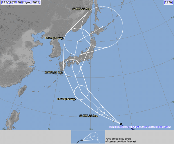
A little southeast of Soulik is Typhoon Cimaron, which is pulling away from the Northern Mariana Islands. Cimaron is a minimal typhoon with maximum sustained winds near 75 mph, but steady strengthening is expected over the next 24-36 hours. Cimaron is expected to take a northwest track, passing close to Iwo Jima before turning more towards the north by midweek. After that it will likely head towards Japan, with landfall expected later this week as a minimal typhoon, likely around the same time that Soulik is impacting Korea. Cimaron will bring strong winds, and heavy rain to an area that was already recovering from deadly flooding earlier this summer.
While the Pacific remains somewhat active, the Atlantic is still quiet. While the forecast models show this continuing for the remainder of August, climatology says that the trend won’t continue into September, as the peak of hurricane season is mid-September climatologically. The pattern remains unfavorable for storms to form now, but it remains to be seen if that pattern will continue into September.