It’s been a fairly slow start to hurricane season in the Atlantic, which is fairly normal, but things are starting to heat up in the Gulf of Mexico.
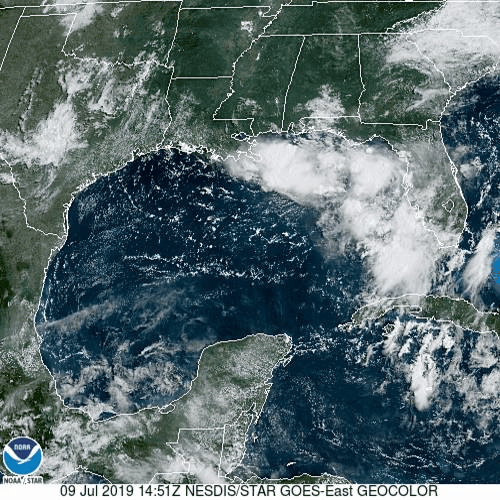
A disturbance dropped southward from the Tennessee Valley over the weekend, moving into the Gulf of Mexico on Tuesday. With plenty of warm water and only a little wind shear, the system is starting to get organized this afternoon, and could become a tropical depression later today or on Thursday.
As of 2pm Wednesday, the system was centered about 155 miles east-southeast of the mouth of the Mississippi River, moving toward the west-southwest at 8 mph. It is producing sustained winds of 30 mph, with some higher gusts. Steady strengthening is expected for the next few days. A Tropical Storm Watch has been posted from the Mouth of the Mississippi River to Morgan City, Louisiana. A Storm Surge Watch has also been posted from Pearl River to Morgan City.
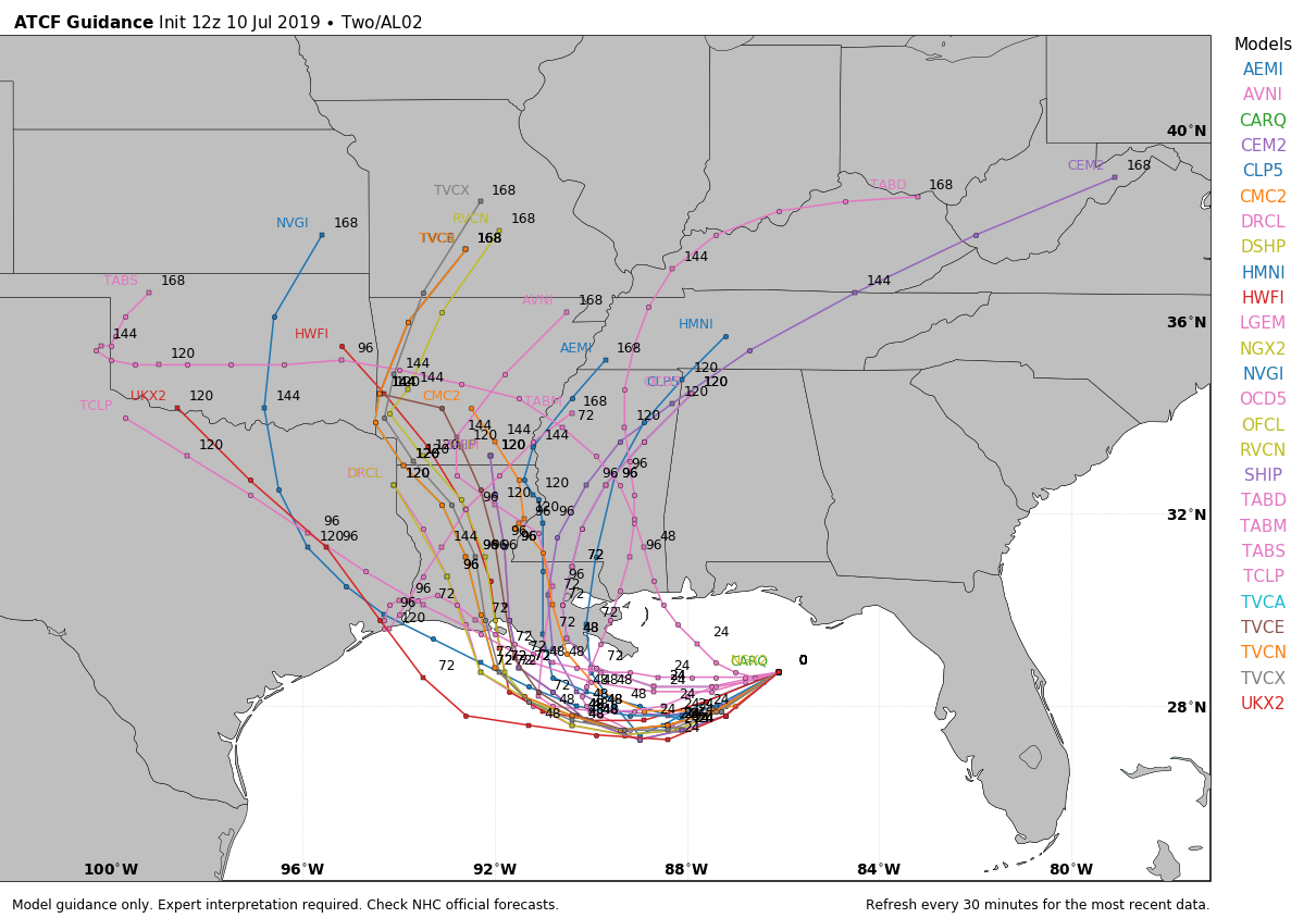
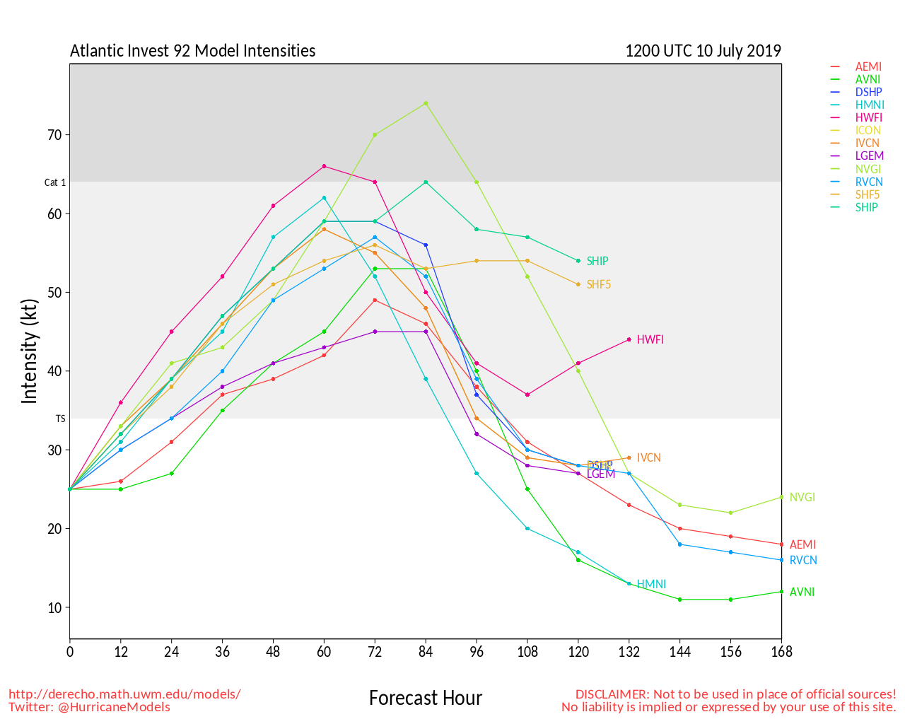
The forecast models are fairly unanimous that the system will continue westward for the next 36-48 hours, but after that point things become unclear. A turn toward the northwest and eventually north is expected as an upper-level trough moves into the Great Plains, but when that turn occurs has a very significant impact on the system. A quicker turn means that the storm spends less time over the warm waters of the Gulf, and thus has less time to strengthen. A later turn means the opposite, more time over water, more time to strengthen, and the greater likelihood of it becoming a hurricane. Intensity forecasts are notoriously poor to begin with, and this system is no different. Very few models are predicting the system to reach hurricane strength, but the National Hurricane Center’s official forecast does call for the system to become a hurricane before landfall. As we mentioned already, the eventual track of the system will play a large part in determining this.
Storm surge is a danger with any storm system, and this one is no different. Storm surge of 2-4 feet is likely near where the center makes landfall. Since much of southern Louisiana is already low-lying, this could result in flooding for much of the region. Wind damage will also be a concern across the region, which again will be dependent on the strength of the system. Winds will pick up Friday night across portions of Louisiana and possibly eastern Texas, with landfall most likely on Saturday right now, but this is obviously subject to change.
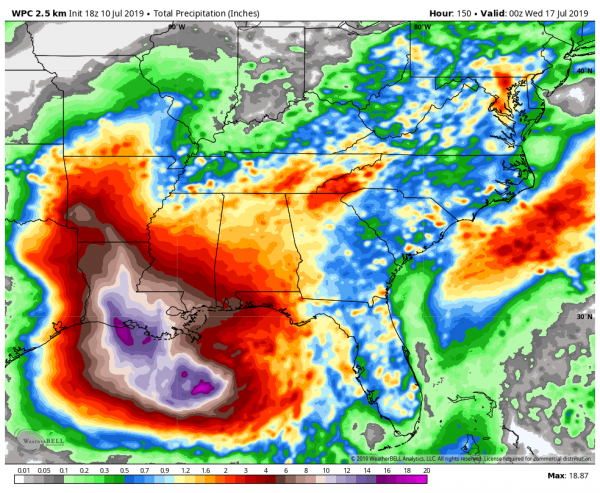
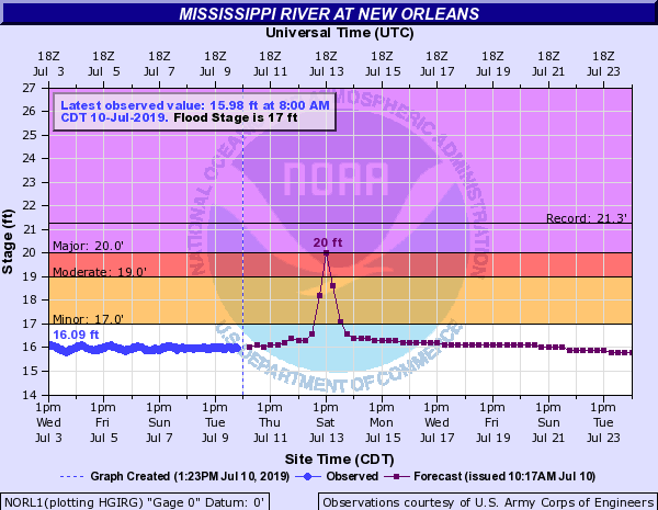
By far, the biggest threat with this system will be rainfall. Tropical systems produce copious amounts of rainfall, and this one will be no different. Rainfall totals of 6 to 12 inches are expected across parts of the Gulf Coast, with some amounts to 20 inches possible. This would produce widespread flooding across the region, but in this case, it will just exacerbate existing flooding problems. The Mississippi River remains above flood stage across the region, and this will only worsen the flooding. On top of that, thunderstorms dropped up to 10 inches of rain on parts of New Orleans Wednesday morning, and that’s before the precipitation from the system even reaches the area. The Mississippi River is expected to crest in New Orleans at a level of 20 feet, which is also the same height that the levee system protects the city to. Obviously this will bear watching. Upstream, the River has been above “Major Flood” stage in Baton Rouge since February 26. It’s not likely to drop below flood stage until at least some time in August, if then.
Elsewhere, the Atlantic remains quiet, with no other systems expected to develop in the next week or so.