While crossing the Bahamas on Saturday, Hurricane Isaias weakened to a tropical storm, but it remains a threat to much of the East Coast.
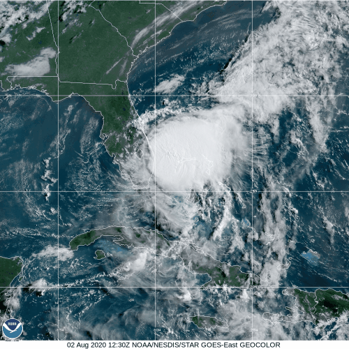
As of 5pm Sunday, Tropical Storm Isaias was centered about 65 miles southeast of Vero Beach, Florida, moving toward the north-northwest at 9mph. Based on data from reconnaissance aircraft and Doppler Radar on the Florida coast, maximum sustained winds have increased to near 70 mph, and should remain near that level for the next day or two, with some fluctuations in strength possible.
Tropical Storm Warnings are in effect from Sebastian Inlet, Florida to Ocracoke Inlet North Carolina. A Hurricane Watch has also been issued from South Santee River, South Carolina to Surf City, North Carolina. A Storm Surge Warning is now in effect from Edisto Beach, South Carolina to Cape Fear, North Carolina and a Storm Surge Watch is in effect north of Surf City to Duck, North Carolina, including Albemarle and Pamlico Sounds. In additional, the Tropical Storm Watch has been extended northward, now extending from Ocracoke Inlet, North Carolina to Watch Hill, Rhode Island. This includes Chespeake Bay, the Tidal Potomac River, Delaware Bay, and Long Island Sound, as well as the cities of Washington and New York.
Isaias moved across the Bahamas as a hurricane late Friday into early Saturday, before weakening to a Tropical Storm Saturday afternoon. The combination of southwesterly wind shear and some dry air due to Saharan Dust contributed to the weakening. Isaias is maintaining its strength this afternoon despite the presence of more wind shear.
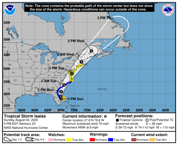
Isaias should continue to head towards the north tonight and Monday, in between a large area of high pressure of the east, and an approaching trough of low pressure from the west. As the trough continues to move towards the East Coast, it will help turn Isaias more towards the north-northeast and eventually northeast. On this track, Isaias will parallel the coast of Florida and Georgia tonight and Monday, then likely make landfall in either South Carolina or North Carolina late Monday night or early Tuesday. Once inland, Isaias will continue northeastward, and although it will weaken a bit, it should maintain some strength as it moves up the coast, as it starts to transition into an extratropical storm.
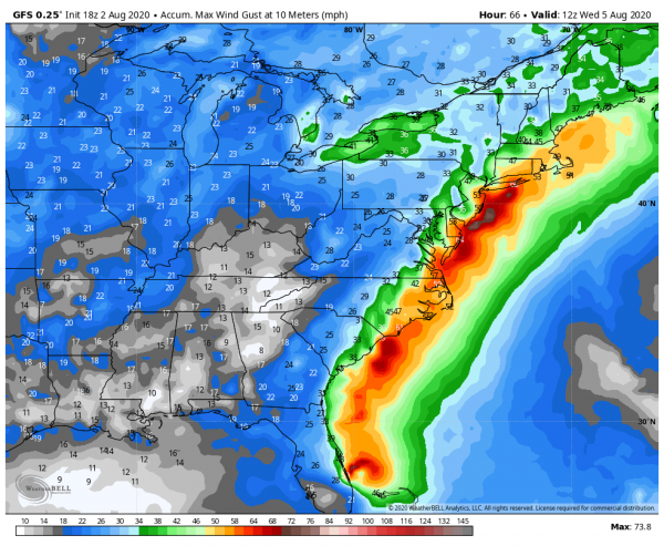
Storm surge will be a threat along the Carolina coast, near and east of where the center makes landfall. A surge of up to 4 feet above normal tide levels could result in some coastal flooding. Strong winds will also be a threat, mainly east of the storm’s center. Winds have been gusting as high as 50 mph along the Florida coast this afternoon. As it moves northward, some strong winds will be likely across eastern North Carolina as the storm moves inland, and possibly across eastern New England late Tuesday into early Wednesday as the system moves across the Northeast.
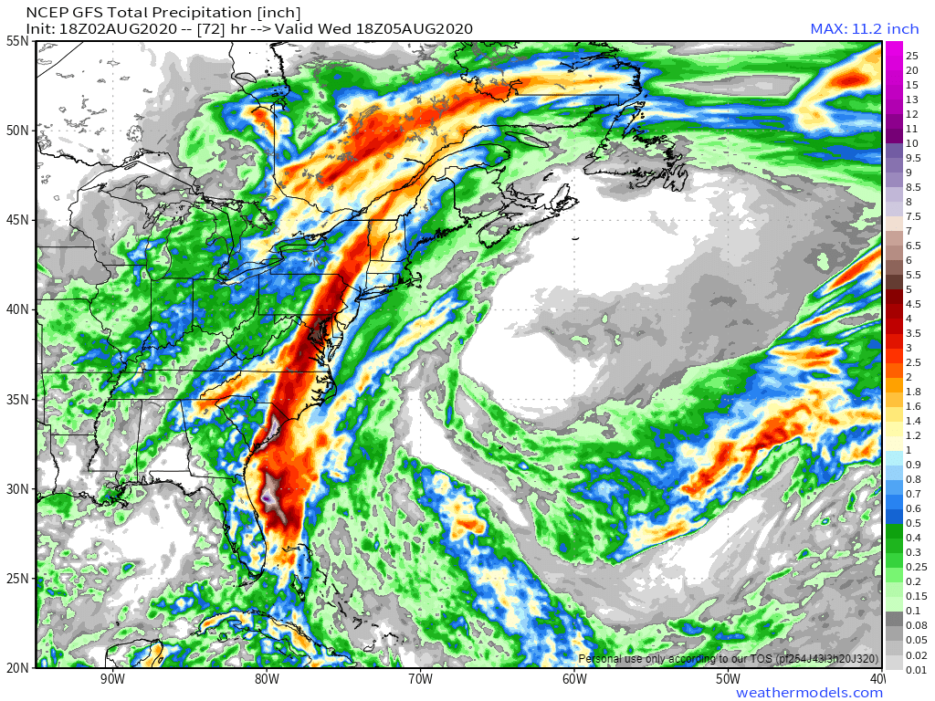
By far, the biggest threat with Isaias is heavy rainfall and the resulting flooding. Some bands of heavy rain have moved across parts of Florida, and that will continue through tonight. Rainfall totals of 1-3 inches are possible across parts of Florida and Georgia over the next 24-36 hours. As you head north, heavier rain is likely from the Carolinas into the Mid-Atlantic states and the Northeast, mainly along and west of the storm’s track. Rainfall totals of 3-6 inches and locally heavier are likely, which will produce flooding in many areas. The storm’s relatively quick motion will preclude even heavier totals. East of the storm’s track, rainfall will be much lighter, with many places likely seeing less than 1 inch.
Elsewhere, we’re keeping an eye on a tropical wave located a few hundred miles east of the Leeward Islands. Conditions could become favorable for it to develop into a tropical depression in a few days. Model forecasts show it heading northwestward, staying north of the Caribbean over the next few days. By mid-week, most forecasts show it stalling out about midway between Bermuda and the Bahamas. It does not look like a threat to any land areas at this time.