Tropical Storm Fay developed off the North Carolina coastline Thursday evening, the sixth named storm of the season.
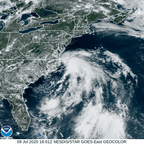
A disturbance that moved from the Gulf of Mexico and into the Southeast last week moved off the South Carolina coast on Wednesday. After sitting over the warm waters of the Gulf Stream, thunderstorm activity began to increase, and a new center of circulation developed Thursday afternoon. Air Force Reserve Hurricane Hunters investigating the system determined that it had a closed circulation, and the system was designated as Tropical Storm Fay.
Fay is the 6th named storm of the season (Whether all 6 deserved to be named is debatable), and is the earliest we’ve ever had an “F” storm in the Atlantic. The previous record was held by Tropical Storm Franklin during the 2005 season, which developed on July 22.
Tropical Storm #Fay has formed off of the coast of North Carolina – the earliest 6th Atlantic named storm formation on record. Previous record was Franklin in 2005 on July 22nd. #hurricane pic.twitter.com/gJFhXbSRZJ
— Philip Klotzbach (@philklotzbach) July 9, 2020
While there are still a few details that need to be determined, Fay’s future is fairly clear. With a ridge of high pressure in the western Atlantic, and a trough of low pressure moving into the Great Lakes, Fay should head northward for the next 24-48 hours, paralleling the Mid-Atlantic coastline. While the official forecast from the Hurricane Center keeps the center just offshore until it makes landfall near New York City Friday night, a slight jog to the west would bring the center into the New Jersey coastline. A Tropical Storm Warning has been issued from Cape May, New Jersey to Watch Hill, Rhode Island, including Long Island Sound. This includes all of Long Island and New York City.
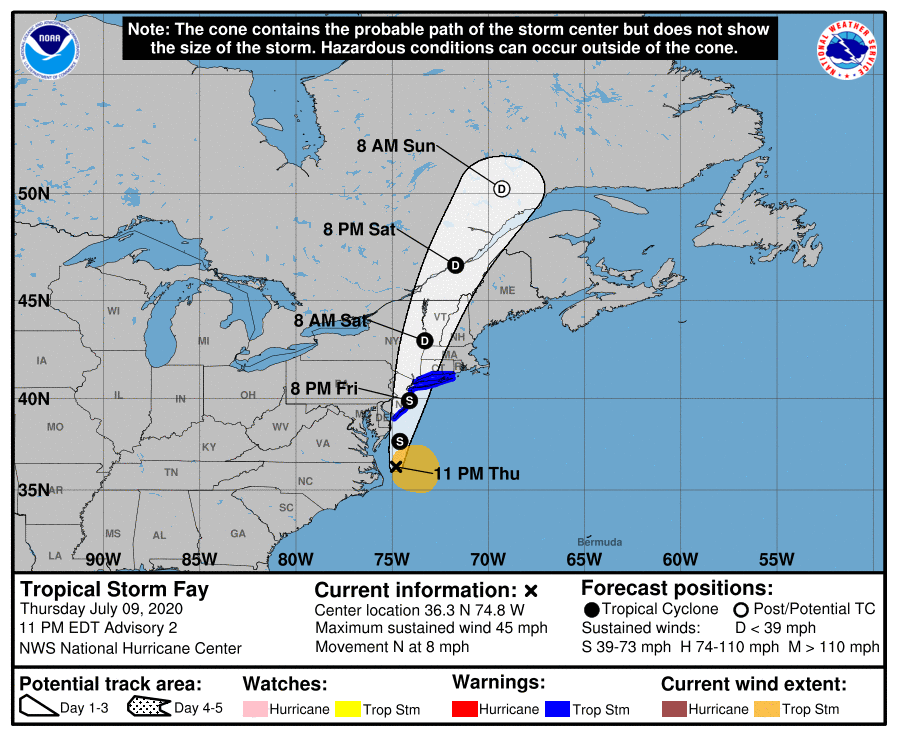
Fay currently has maximum sustained winds near 45 mph, and some modest strengthening is possible overnight and early Friday. The storm is moving northward at 8 mph, and should pick up a little speed on Friday. This track will keep most of the strongest winds offshore, until the center reaches Long Island Friday night.
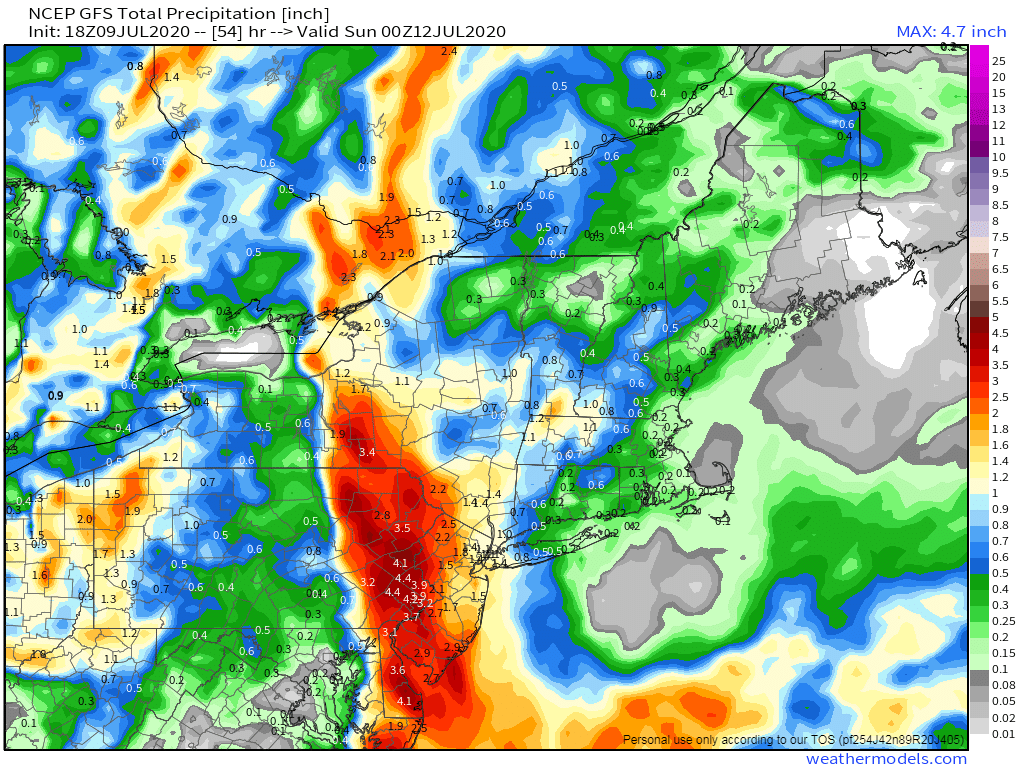
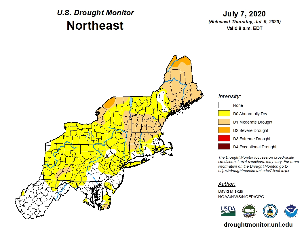
Fay’s biggest threat will be heavy rainfall that could lead to flash flooding, especially from the Mid-Atlantic states into eastern New York and western New England. Much of this region has been dry for a few months, and drought conditions are beginning to develop. Some of this rainfall will help alleviate that, but too much rainfall too quickly will just run off and not help much at all. By the time Fay pulls away early Saturday, rainfall totals of 2-5 inches are expected from the Delmarva Peninsula into western New England and eastern New York, mainly along and just west of the expected track of Fay. Some isolated totals in excess of 6 inches are possible. Amounts will taper off the farther east or west you head away from this area.
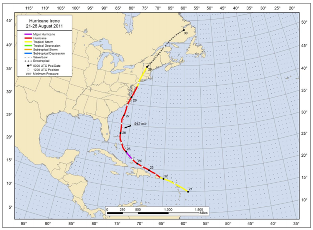
This track is very similar to the track that Hurricane Irene took in 2011. Irene had weakened to a tropical storm before crossing New York City and heading up the Hudson Valley, producing significant flooding across western New England. Irene is the last tropical system to make landfall in New York or New England. On average, a tropical storm makes landfall in this area once every 4.7 years, and the 9 years without a storm is just shy of the record of 11 years the region went between 1923 and 1934. The last hurricane to make landfall in the region was Bob in 1991. The 29 year deficit is triple the average of 9.4 years between storms, and is the 2nd longest drought on record, trailing the 38-year drought between 1896 and 1934.
Once Fay dissipates, there don’t appear to be any other areas that may develop in the next week or two. It’s still early in the season, and easterly waves will begin rolling off of western Africa soon, with the climatological peak of hurricane season still more than a month away.