After dumping feet of rain on portions of southern Mexico and Central America, Cristobal is now gaining strength into the Gulf of Mexico and heading towards the central Gulf Coast.

As of Friday evening, Tropical Storm Cristobal was located about 440 miles south of the mouth of the Mississippi River, moving toward the north at 14 mph. Maximum sustained winds have increased to near 45 mph. Cristobal should continue moving toward the north overnight and Saturday, with some strengthening expected.
Cristobal is a bit of a lopsided system right now, with most of the rainfall along with the strongest winds all located east of the center of the storm. While some of the rainfall will eventually rotate around to the western side of the storm, the overall structure of the system likely won’t change much over the weekend. This has important implications as the system approaches land.
As Cristobal moves away from Mexico, some additional strengthening is expected. The waters of the Gulf are very warm, which will help the storm intensify, but the presence of dry air aloft and some wind shear will act to inhibit significant strengthening. Cristobal should strengthen a bit more on Saturday, but at this time, it does not look like it will become a hurricane before approaching the central Gulf Coast late Sunday.
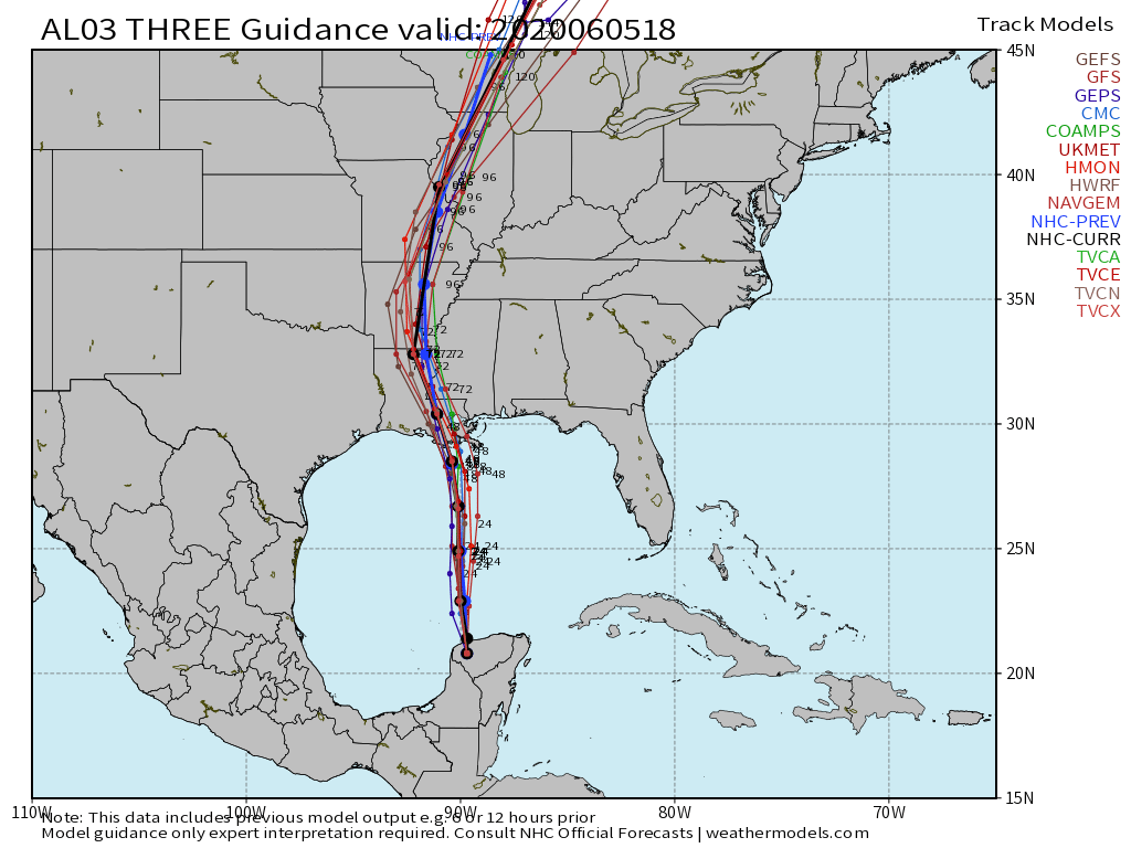
The current forecast calls for Cristobal to make landfall as a tropical storm along the coastline of Louisiana late Sunday afternoon or Sunday evening. A Tropical Storm Warning has been issued from Morgan City, Louisiana to the border of Okalaoosa and Walton Counties in Florida. This includes Lakes Ponchatrain and Maurepas. A Tropical Storm Watch is in effect west of Morgan City to Intracoastal City. A Storm Surge Warning has also been issued from the Mouth of the Mississippi Rover to Ocean Springs, Mississippi, including Lake Borgne. A Storm Surge Watch is in effect from the Mouth of the Mississippi River westward to Morgan City, Louisiana, and also along the coast of Florida from Indian Pass to Arepika.
As mentioned earlier, Cristobal is a bit lopsided, and this should still be the case as the storm moves inland Sunday night. That’s not to say that areas west of the center will escape without issues, but they shouldn’t be as problematic. There will still be some heavy rain, and wind gusts to 30-40 mph, but this isn’t anything the region hasn’t experienced plenty of times before. Near and east of the center are where the problems will become more numerous.
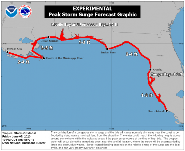
Cristobal should have sustained winds of 50-60 mph near the center at landfall, but these winds will only be experienced over a small area along the coast. The remainder of the area will likely have sustained winds of 30-40 mph, with some gusts to 50-60 mph. Along the coast, a storm surge of up to 3-5 feet will result in flooding of some areas, especially the low-lying locations near the Mississippi River entrance. By far, the biggest threat is heavy rain.
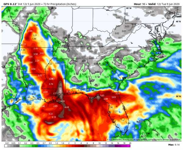
Rainfall totals of 4-8 inches are expected across a wide area, with isolated totals to 12 inches possible. This will lead to flooding across much of the region. Flood watches have already been issued. Parts of the Gulf Coast have actually been in a drought recently, but too much rain in a short period isn’t a good thing. Once inland, Cristobal should weaken and head northward, bringing heavy rain to parts of the Mississippi Valley and the Great Lakes early next week.
Tropical Depression Three formed in the Bay of Campeche Monday afternoon and strengthened into Tropical Storm Cristobal Tuesday afternoon. It made landfall along the coast of Mexico Wednesday morning, and has been drifting around southeastern Mexico and Guatemala for the past 48 hours. Cristobal has produced torrential rainfall, with 15-25 inches of rain reported across much of the region, resulting in widespread flooding. Another 3-6 inches of rain, possibly more, is expected across this region before the system pulls away over the weekend.