The tropics had been relatively quiet in the past couple of weeks, but now there are suddenly 3 storms that are all threats to land by the end of the weekend.
The most immediate threat is Tropical Depression 8. As of 11am EDT, the system was centered about 380 miles east-southeast of Port O’Connor, Texas, moving toward the west-northwest at 9 mph. Maximum sustained winds were near 35 mph. The system should continue on a general westward track for the next day or two, with some strengthening possible. If it does strengthen, it would be named Tropical Storm Hanna. Since this is possible, a Tropical Storm Watch is in effect for most of the Texas coast from Port Mansfield to High Island.
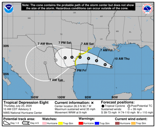
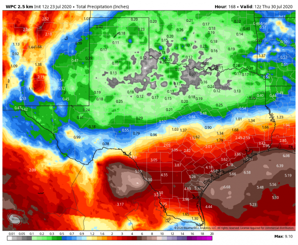
While gusty winds and some rough surf are likely along the Texas coast, the biggest threat from this system will be heavy rainfall. Slow-moving tropical systems have produced significant rainfall in Texas many times before, and while we’re not expecting 50+ inches like Hurricane Harvey produced a few years ago, widespread totals of 3-6 inches with isolated amounts of up to 10 inches are possible through this weekend and early next week. That would likely produce flooding in many areas.
While TD 8 is the immediate threat to the US, out in the Atlantic, Tropical Storm Gonzalo presents a threat to the Southern Windward Islands. As of 11am EDT, Gonzalo was centered about 885 miles east of the southern Windward Islands, moving toward the west at 14 mph. Maximum sustained winds were near 65 mph. A Hurricane Watch is in effect for Barbados as well as St. Vincent and the Grenadines.
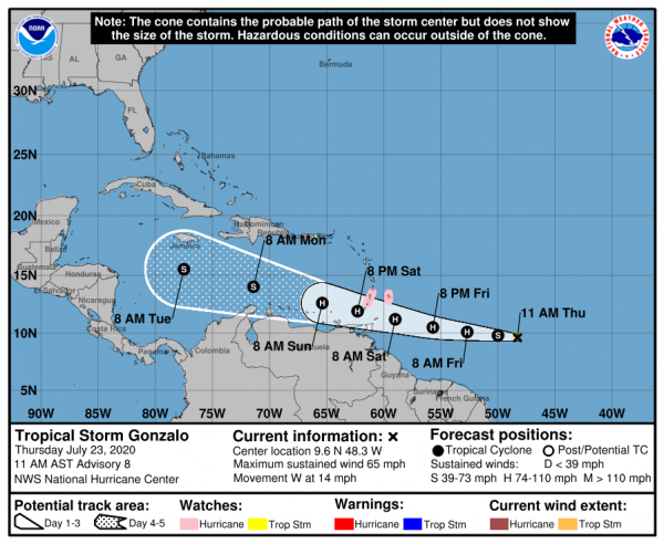
Gonzalo’s future is very uncertain at this point. The official forecast from the National Hurricane Center calls for Gonzalo to become a hurricane later today, then start to weaken after moving across the Windward Islands this weekend and into the eastern Caribbean. However, Gonzalo looks less organized on satellite photos today, and is fighting off some dry air aloft. There is a decent chance that the system could weaken or even open up into a wave before reaching the Windward Islands. How it develops over the next 12-24 hours will give us a much better idea of what the future holds for it.
In the Eastern Pacific Ocean, Hurricane Douglas continues to strengthen this morning, and could become a threat to Hawaii this weekend.
As of 11am EDT, Douglas was centered about 1335 miles east-southeast of Hilo, Hawaii, moving toward the west-northwest at 20 mph. Maximum sustained winds have increased to 120 mph, making Douglas a Category 3 storm on the Saffir-Simpson scale. Some additional strengthening is possible today before a weakening trend begins on Friday as Douglas moves over cooler waters.
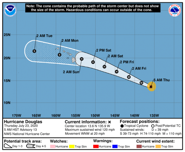
Douglas is expected to only gradually weaken while heading towards the west-northwest over the next several days. On this track, Douglas is expected to pass close to or over parts of the Hawaiian Islands this weekend. Obviously which islands would be impacted and what the threats would be will depend on the exact track Douglas takes, as well as how quickly it weakens. At this point, gusty winds, heavy rainfall, and rough surf appear mostly likely for the Big Island, but the entire island chain could be impacted.
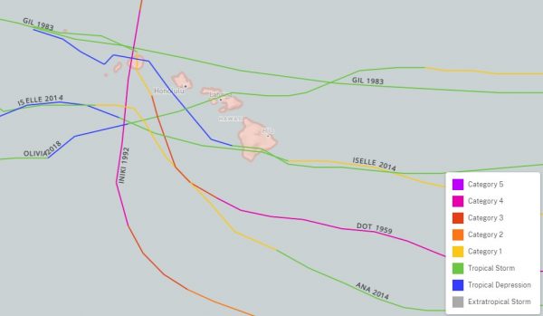
While Hawaii has been impacted by many weakening storms passing by the islands, a direct hit is actually fairly rare. Since 1871, only 3 hurricanes and 4 tropical storms have actually made landfall on the islands. The last system to make landfall in Hawaii was Tropical Storm Olivia in 2018. The last hurricane to make landfall in Hawaii was Hurricane Iniki in 1992.
Beyond these systems, there’s nothing on the immediate horizon. Some of the longer-range ensemble models are showing the potential for a wave to move off the the African coast and develop while crossing the Atlantic next week. This is still several days away, and while the likelihood of it happening is fairly low, we are getting into the time of year when some of these waves do start rolling off of Africa and maintain themselves while crossing the Atlantic.