The Tropics Remain Fairly Quiet

By most metrics, the first 6-8 weeks of hurricane season has been fairly quiet across the Northern Hemisphere.

Tropical Cyclone Activity has been near to below normal across the Northern Hemisphere. Image provided by Colorado State University.


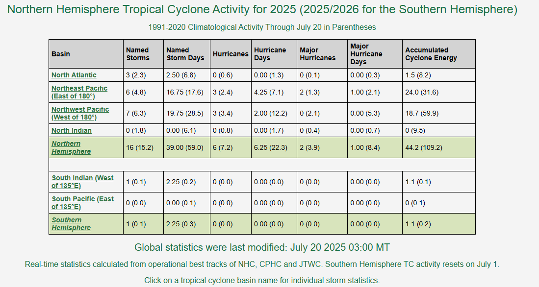
Going strictly by the number of named storms, activity has been near normal across the Atlantic and Pacific, and below normal in the Indian Ocean, where no storms have developed so far this season. However, the number of storms does not tell the entire story. To get a better view of how active a season has been we use a metric called Accumulated Cyclone Energy or ACE for short. ACE is calculated for all storms that are at least tropical storm strength by summing the square of a storm’s maximum sustained wind speed every 6 hours, then dividing that number by 10,000. Using this metric, activity is running about 44% of normal across the Northern Hemisphere, and less than 40% of normal across the Atlantic.

In the Atlantic, there have only been 3 short-lived tropical storms thus far this season, and 2 of them were very weak, which is why the ACE for the Atlantic is so low. In the Eastern Pacific there have been 3 hurricanes, 2 of them major hurricanes (Category 3 or stronger), resulting in a higher ACE, but it is still below normal for this point in the season. The same holds true for the Western Pacific, where there have only been 3 typhoons so far this year.

Bursts of Saharan Dust will continue to cross the Atlantic over the next week. Loop provided by Weathermodels.com


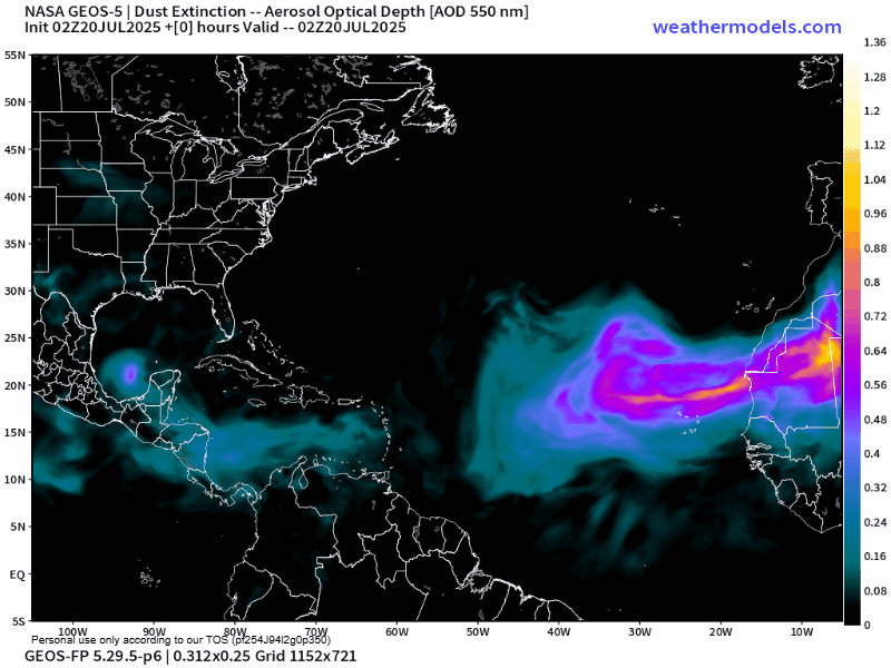
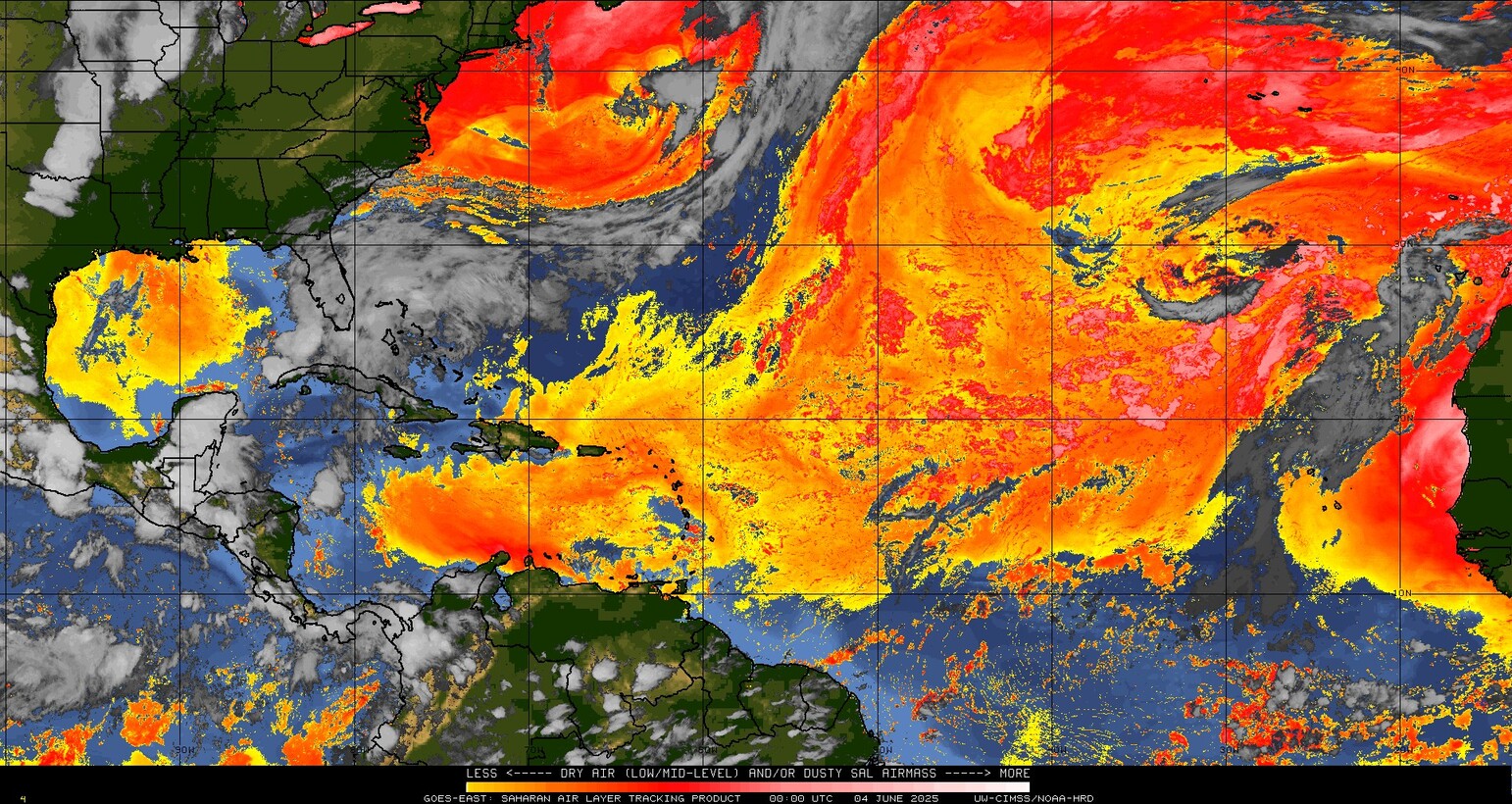
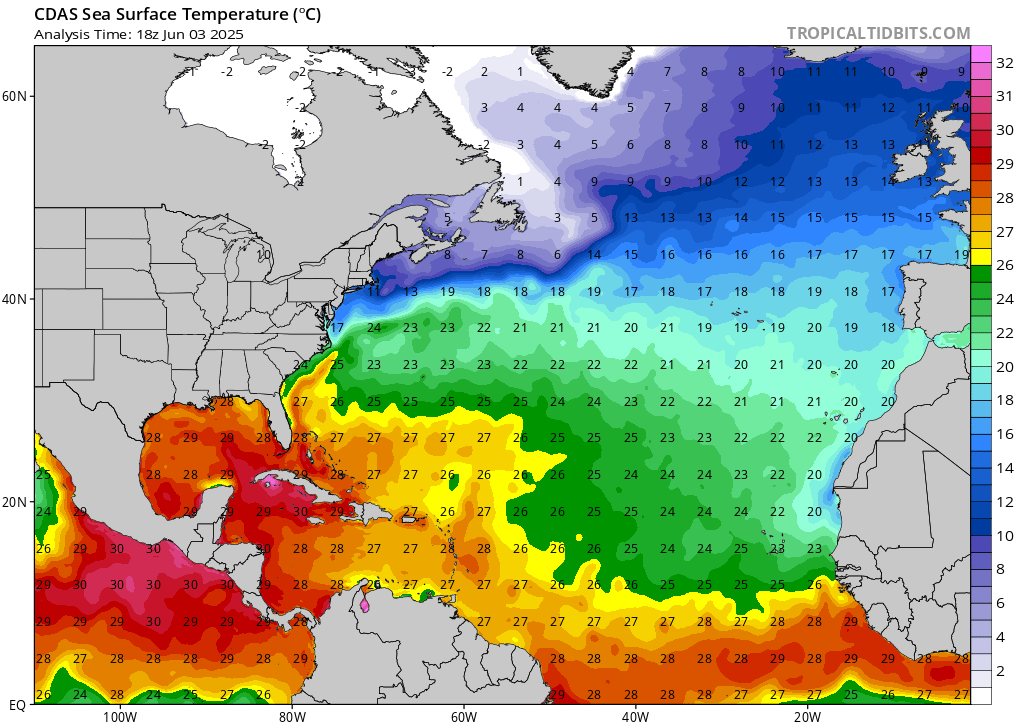
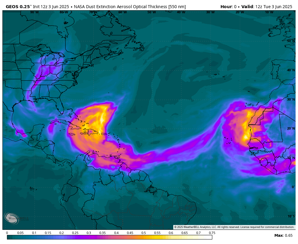
In the Atlantic, conditions have remained unfavorable for the most part, as sea surface temperatures are still a little too cool across the Main Development Region, but bursts of Saharan Dust continue to move off of Africa and across the Atlantic every few days. These bursts suppress shower and thunderstorm activity with very dry air as they make their way westward. As we get into August, the Saharan Dust outbreaks should become less numerous, and sea surface temperatures across the Atlantic should continue to rise, allowing for more favorable conditions to develop.


There is a very low probability that a system well east of the Caribbean could develop in the next few days. Image provided by the National Hurricane Center.


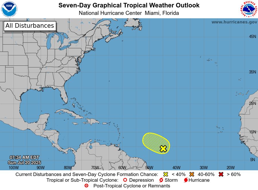
There are 2 areas that we are currently monitoring across the Atlantic at the moment, though both have slim odds of developing at this point. A tropical wave centered about 1000 miles east-southeast of the Lesser Antilles is producing disorganized showers and thunderstorms. There is a small window for some development over the next day or two, but after that, conditions will become more hostile once again, well before the wave reaches the eastern Caribbean.

Another disturbance may bring heavy rain to parts of the Gulf Coast and Florida again this week. Image provided by Pivotal Weather.


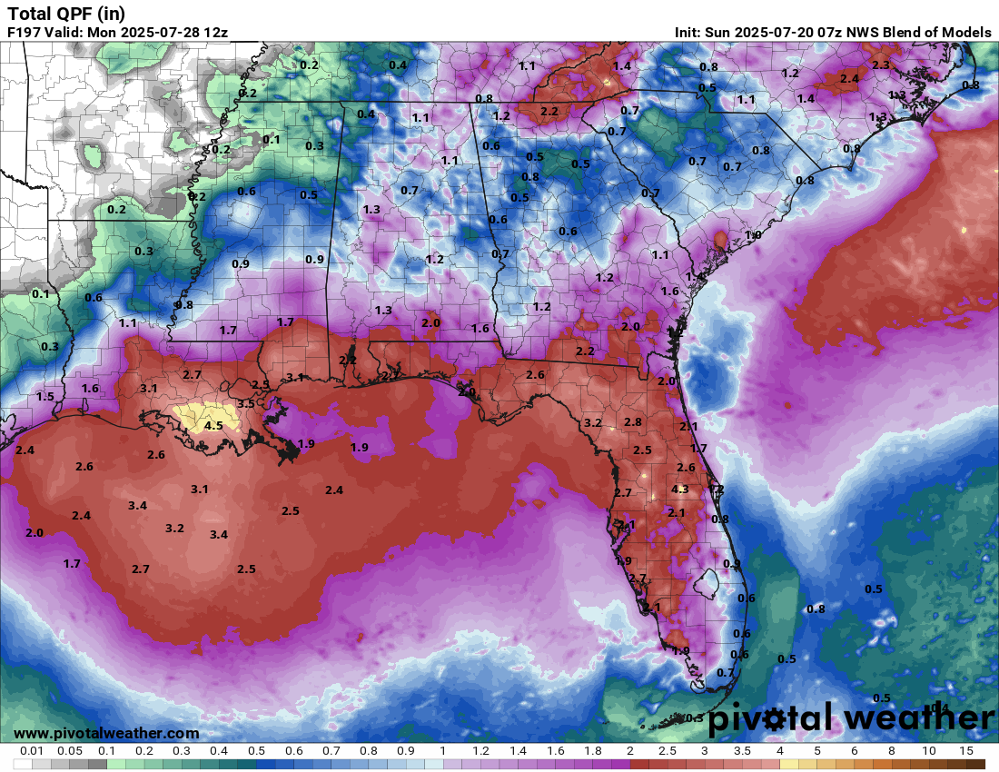
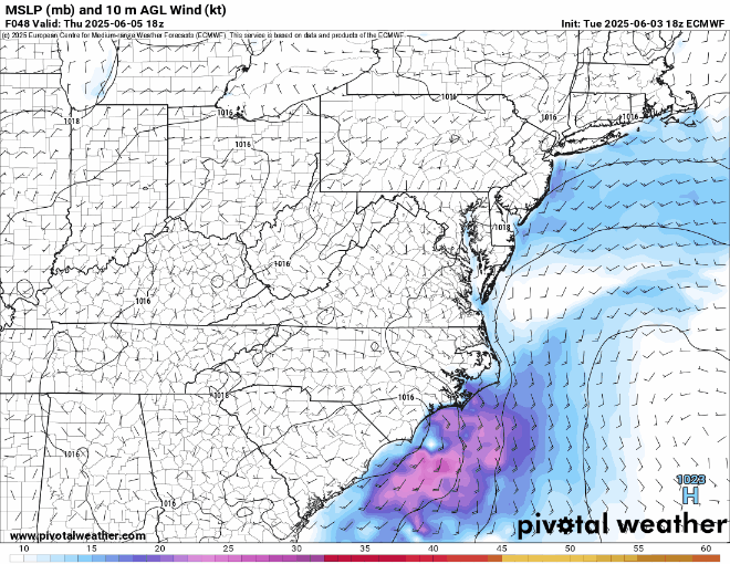
Last week, a disturbance developed off the Southeast coast and moved westward into the Northern Gulf, producing heavy rain and flash flooding across parts of Florida and the Gulf Coast. The system did not develop before moving inland, and what’s left of it is producing showers and thunderstorms across parts of the Deep South and the Southeast. Forecast models are showing the potential for this system to move back out off the Southeast coast again in the next few days, then head westward around the periphery of a ridge of high pressure and back into the Gulf during the upcoming week, with some potential for development once again. At the very least, it will likely bring some more heavy rain to parts of the Gulf Coast, but the odds of development remain low.

Typhoon Wipha made landfall just west of Hong Kong early this morning. Loop provided by Tropical Tidbits.


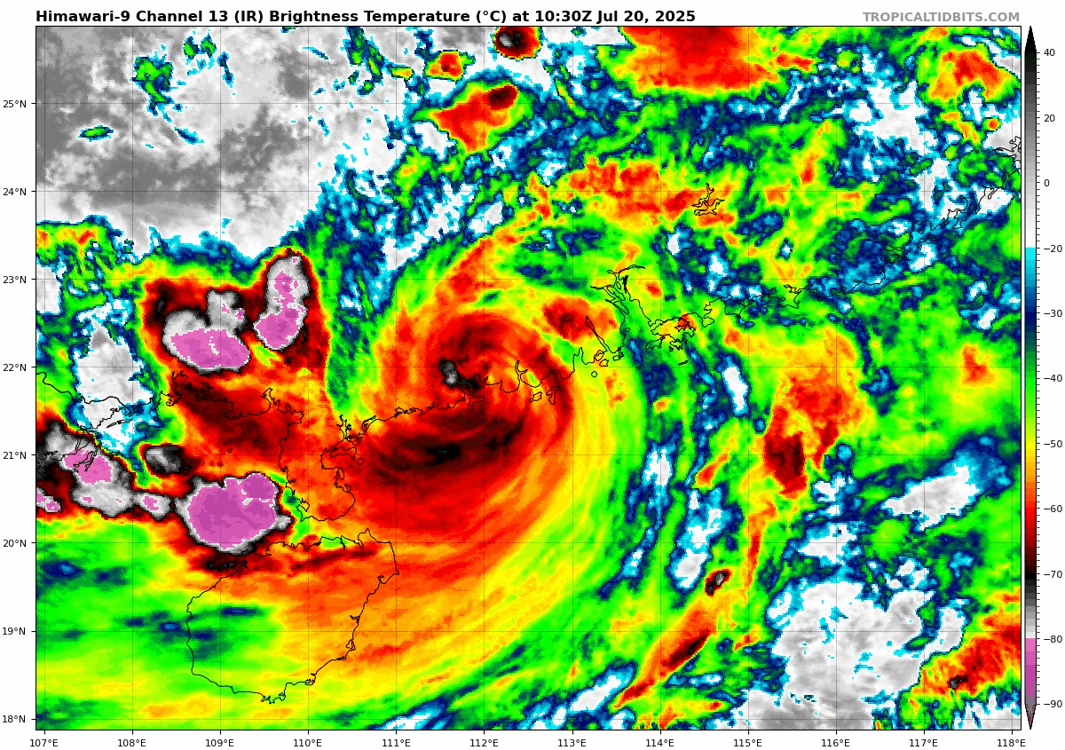
In the Western Pacific, Typhoon Wipha passed just south of Hong Kong early this morning, producing wind gusts of up to 82 mph, and dropping as much as 5-10 inches of rain on the region. After making landfall just west of Hong Kong, Wipha should slowly weaken while paralleling the coast of southern Guangdong Province today. It may emerge in the Beibu Gulf (a.k.a. Gulf of Tonkin) on Monday. If it does, it could restrengthen a little before a second landfall in northern Vietnam. Whether it does or not, heavy rain and flooding are likely across parts of Southern China and northern Vietnam over the next few days.

Saharan Dust Suppressing Tropical Activity in the Atlantic

Atlantic hurricane season is off to a slow start, which is fairly normal despite the early start in many recent years, and one of the main reason has been Saharan Dust.

Saharan Dust and dry air covers much of the Tropical Atlantic and Caribbean. Image provided by the University of Wisconsin-Madison.


In the mid-latitudes, most systems move from west to east, but in the tropics, it’s the opposite, with systems moving from east to west. We see this all the time with tropical waves and once they develop, most tropical systems head towards the west across the Atlantic. Early in the season though, these easterly winds will send large plumes of sand and dust off the Saharan Desert and into the Atlantic, where the prevailing winds carry them across the ocean.

Satellite loop showing a plume of Saharan dust crossing the Atlantic and Caribbean. Loop provided by NOAA.


As these plumes move across the Atlantic they suppress shower activity, preventing any storms from getting organized. They also limit the amount of sunlight getting through, which keeps the ocean temperatures a little cooler, especially in the Main Development Region of the central and eastern Atlantic. Ocean temperatures in this region are generally too cool for any systems to develop until we get into the latter half of July in a typical season. Tropical systems need to be over water that is 26 Celsius (79 Fahrenheit) or warmer to maintain their intensity or strengthen.

Current sea surface temperatures across the Atlantic. Image provided by Tropical Tidbits.


As the Saharan Dust reaches the Caribbean, it can have detrimental effects on the islands. In additional to produce poor air quality, the lack of cloud cover and shower activity results in very warm to hot temperatures across the islands. Instead of high temperatures in the upper 80s to near 90, temperatures can soar into the lower to middle 90s, with heat indices well in excess of 100. Some of these plumes can make their way into the Gulf and across parts of Florida, the Southeast, and Texas, resulting in hazy conditions.

Model forecast for the progression of Saharan dust across the tropics. Loop provided by WeatherBell.


While water temperatures are not yet warm enough to support tropical systems across the Main Development Region, they are plenty warm enough across the Caribbean, Gulf, and off the Southeast Coast near the Gulf Stream. At this time of year, we typically see clusters of showers and thunderstorms from southern Mexico across Central America and into the western Caribbean. These storms are part of the larger Central American Gyre, a very broad rotating area of showers and thunderstorms that can result in very heavy rain and flooding in parts of Central America. Sometimes you’ll see activity break off from this gyre and develop into a tropical depression or tropical system on either the Caribbean side or the eastern Pacific side of Central America. While nothing is imminent, this is an area to watch for development early in the season.

Most early season storms will likely develop in either the Gulf, Western Caribbean, or near the Bahamas. Image provided by the National Hurricane Center.


Another area that needs to be watched is near the Bahamas and off the Southeast coast. As cold fronts stall out and dissipate in this region, they can leave behind clusters of showers and thunderstorms. If they stay over the warm waters of the Gulf Stream long enough, they could eventually develop into a system. This is something that we are watching at the moment. Showers and thunderstorms have been producing heavy rain across Florida for the past few days, and will slowly drift northeastward this week. Some of the forecast models show the potential for a weak area of low pressure to develop off the Southeast coast, but whether or not it is tropical is yet to be determined. The system is likely to remain very weak, though it may produce some heavy rain and gusty winds for portions of the Carolinas, but it will get absorbed by another cold front this weekend, which will usher it out to sea and away from the East Coast.

Forecasts models show the potential for a weak system to develop near the Carolinas later this week. Loop provided by Pivotal Weather.
Back to top