Atlantic hurricane season officially starts on Monday June 1 and runs through November 30, and most forecasts are showing the potential for a less active season, thanks to a developing El Nino in the Pacific.
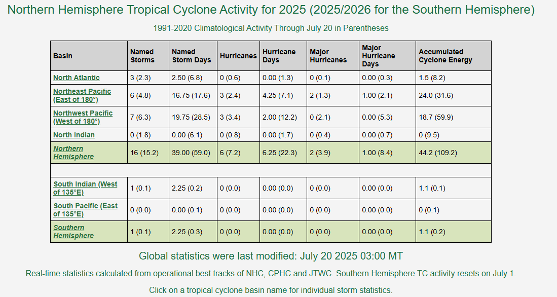
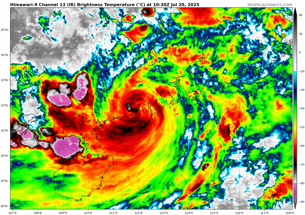
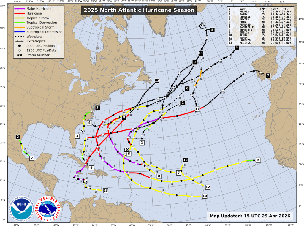
The 2025 season was a near normal season by the numbers, with 13 named storms, 5 hurricanes, and 4 major hurricanes. The season got off to a slower start than recent years, with only 3 storms through the end of July, and 6 through late August. The normal peak of hurricane season is late August and the first 3 weeks of September, but 2025 featured a complete absence of activity during that period. After Tropical Storm Fernand dissipate on August 27, there were no storms at all until Tropical Storm Gabrielle formed on September 17. That was the first of 7 named storms over the next 6 weeks, but once Hurricane Melissa dissipated on Halloween, there were no additional storms for the rest of the season. Hurricane Melissa was not only the strongest storm of the season, it was one of the strongest ever recorded in the basin. While stalling out south of Jamaica it rapidly strengthened into a Category 5 storm with maximum sustained winds near 190 mph, and a central pressure of 892mb not long before slamming into western Jamaica. The sustained winds of 190 are tied with 2019’s Hurricane Dorian, and the 1935 Labor Day Hurricane for the strongest on record in the Atlantic basin. The lowest central pressure of 892mb is tied with the 1935 Labor Day storm for the 3rd lowest on record in the Atlantic, trailing only the 882mb reading in 2005’s Hurricane Wilma, and the 888mb reading in 1988’s Hurricane Gilbert. It also is tied with the 1935 Labor Day storm for the lowest pressure on record at landfall. After the season was over, the name Melissa was retired and removed from the 6-year list of storm names. It will be replaced by Molly in 2031. Melissa is the 100th storm name to be retired in the Atlantic.
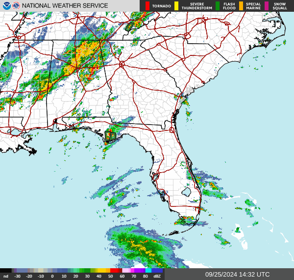
Only one storm made landfall in the US in 2025 – Tropical Storm Chantal, which had maximum sustained winds of 50 mph when its center moved ashore near Myrtle Beach, South Carolina early on July 6. The one landfall is a welcome change from recent years that featured multiple storms making landfall in the US, many of them as hurricanes. In 2021, a total of 8 tropical systems made landfall in the United States, but only 2 at hurricane strength.
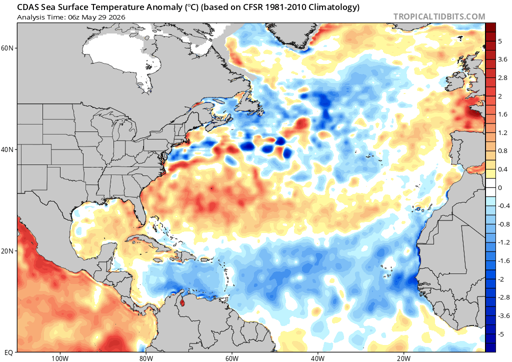
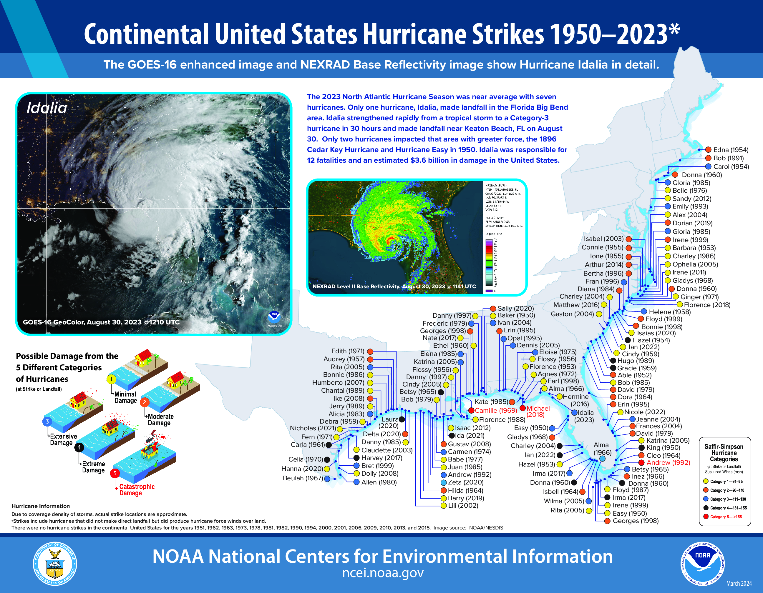
Forecasts for the upcoming season are calling for a season that features below normal activity, due to a developing El Nino in the Pacific Ocean. In fact, there are many forecasts out there calling for a very strong El Nino. In general, where there is an El Nino present, activity in the Atlantic is suppressed, due mainly to increasing wind shear. However, this is not always the case, as El Nino is just one factor. In 2023, we had a strong El Nino in place for much of the hurricane season, and there were 20 named storms that season, making it the fourth most-active season on record. Of those 20 storms, 7 became hurricanes, and 3 were major hurricanes. Hurricane Idalia slammed into the Florida Big Bend region as a Category 3 storm. Sea surface temperatures in the Atlantic are below normal for a large portion of the basin right now, especially in the Main Development Region, but they are forecast to warm to near to above normal levels, which tends to result in more storms.
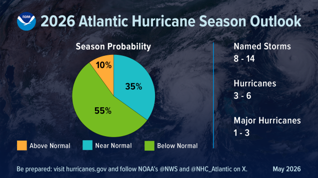
NOAA issued their seasonal hurricane outlook on May 21, and it calls for a 55 percent chance for a below normal season, a 35 percent chance for a near normal season, and just a 10 percent chance for an above normal season. Most of the other hurricane outlooks issued by various outlets are also expecting a near to below normal season, due to the signals mentioned above. An average season consists of 14.4 named storms, of which 7.2 become hurricanes and 3.2 become major hurricanes (Category 3 or higher on the Saffir-Simpson scale). NOAA’s forecast for this season calls for 8-14 named storms, 3-6 hurricanes, and 1-3 major hurricanes. The Tropical Meteorology Project at Colorado State, the first group to forecast how active a hurricane season would be, originally led by the late Dr. Bill Gray, will issue their updated forecast on June 10. Their initial forecast from April called for a below average season, with 13 named storms, 6 hurricanes, and 2 major hurricanes.
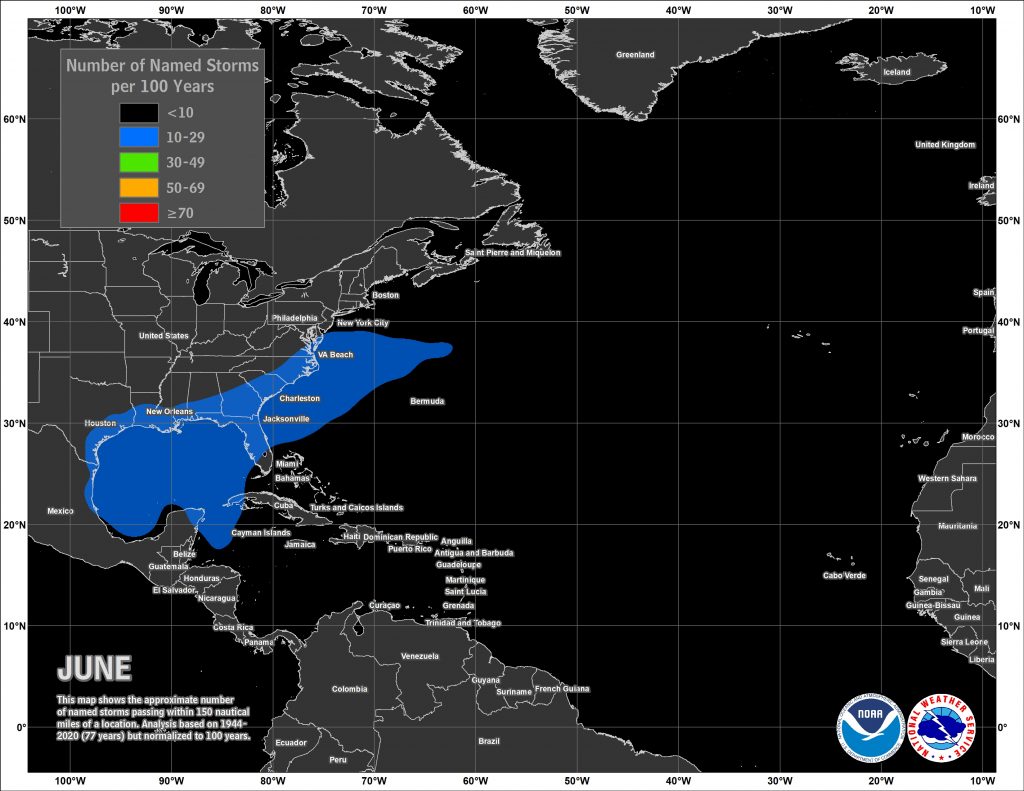
Despite the early start for the many of the past several years, the average date for the first named storm in the Atlantic is still June 20, and the average date for the first hurricane is August 11. Over 97% of all named storms in the Atlantic form between June 1 and November 30. Most early season storms tend to be on the weaker side, as water temperatures are cooler, and wind shear is usually a little stronger. A hurricane hasn’t made landfall in the United States before July 1 since Hurricane Bonnie came ashore as a minimal hurricane near the Texas/Louisiana border on June 26, 1986.
The number of storms that form in any given season has no correlation on how many storms (if any) will impact the United States. In 2010, 19 named storms were observed in the Atlantic, 12 of them became hurricanes, and 5 were major hurricanes. Only one storm made landfall in the United States, and that was Bonnie, which was a minimal tropical storm at landfall. In 1990, there were a total 14 named storms, 8 of them hurricanes and 1 major hurricane. Not a single one of them made landfall in the United States. On the flip side, only 7 named storms formed in 1992, and the first one didn’t develop until August 16. That storm, however, was named Andrew, and it made landfall just south of Miami as a category 5 storm. It only takes one storm to ruin your entire year.
As always, you should get your weather information from a trusted source, especially when dealing with tropical systems. It’s always best to prepare ahead of the season. Chances are, you won’t have anything to worry about, but in case you do, it’s always good to be prepared.