A strong cold front will move across the Northeast on Tuesday, producing showers and thunderstorms across the region, and bringing much drier air into the region.
Showers and a few thunderstorms are expected across the region in the morning. If enough clearing develops after these move out, the atmosphere could destabilize enough to trigger another round of showers and thunderstorms in the afternoon, and some of these could become strong to severe. The Storm Prediction Center is forecasting a marginal risk of severe storms across much of central and southern New England for Tuesday. The main threats with any storms that develop will be heavy rainfall, strong winds, and frequent lightning.
Behind the front, much drier air will settle in, after more than a week with dewpoints of 70 degrees or higher. Temperatures will remain seasonably warm though, unlike areas to the west, where much cooler conditions were noted behind the front. In Rapid City, South Dakota, the low temperature dropped to 41 degrees Monday morning, breaking the old record of 43 degrees, set in 1972. Cheyenne, Wyoming dropped to 39 degrees Monday morning, which also broke a record. The old record low was 40, set 119 years ago in 1896. Several locations in Montana dropped below freezing Sunday morning, with frost reported across parts of the area.
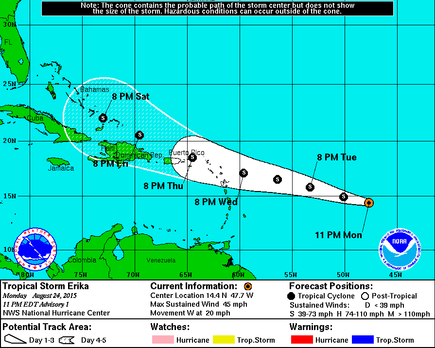
Meanwhile, the tropics remain active. Tropical Storm Erika has formed about 955 miles east of the Leeward Islands. Erika has maximum sustained winds near 45 mph, and is moving toward the west at 20 mph. Erika is expected to slowly strengthen over the next 24-48 hours while turning a bit more towards the west-northwest. The current forecast brings Erika very close to the Northern Leeward Islands Wednesday night or early Thursday. Watches will likely be issued for some of the islands early Tuesday. Beyond that, there is plenty of uncertainty as to where Erika will head and how strong it will be. Some of the models have Erika dissipate over the eastern Caribbean, similar to what happened to Danny, over the next few days, others strengthen it into a hurricane and send it towards the Bahamas.
Since Danny fizzled while it was crossing the Leeward Islands, it brought only a few showers to the Virgin Islands. This region has been in a severe drought for the past several months, and it was hoped that Danny would bring some much -needed rain to the region to help put a dent in the drought. St. Croix, USVI has received only 7.31 inches of rain in 2015, a little over 12 inches below the normal total of 12.33 inches. Things haven’t been much better in San Juan, Puerto Rico, where 21.8 inches of rain have fallen this year, 10.38 inches below the normal for the year-to-date.
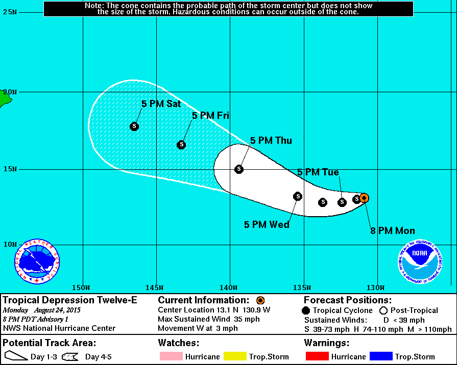
Meanwhile, in the Eastern Pacific, Tropical Depression 12-E formed late Monday. The depression was centered about 1535 miles west-southwest of the southern tip of Baja California with top winds near 35 mph. The depression was drifting toward the west at 3 mph, but should start to turn more towards the west-northwest and pick up speed over the next few days. The system should strengthen into a tropical storm over the next day or so and head out over the open waters of the Pacific, not threatening any land areas. Another tropical wave south of Mexico could develop into a tropical depression later this week as it moves across open waters.
In the Central Pacific, Tropical Depression Kilo has top winds near 30 mph and is centered about 150 miles east of Johnston Island. It is expected to drift toward the north then turn toward the west over the next few days with some slow strengthening expected. Kilo is not expected to impact any land areas for the next few days. Meanwhile, Hurricane Loke is located over 1000 miles west-northwest of the main Hawaiian Islands, crossing the Pearl and Hermes Atoll with top winds near 75 mph. Loke is expected to turn towards the north-northwest and head out over the open waters of the North Pacific while losing tropical characteristics over the next few days.
In the Western Pacific, Typhoon Goni has crossed southwestern Japan and is moving into the Sea of Japan Tuesday afternoon. Goni still has top winds near 95 mph, but is expected to steadily weaken as it crosses the Sea of Japan and heads toward far eastern Russia. Goni produced a wind gust to 102 mph in Makuazaki when it made landfall on Monday. On Sunday, Goni crossed the Ryukyu islands, southwest of the Japanese mainland. As the storm passed directly over Ishigakijima, it produced a wind gust to 159 mph.