As an arctic airmass pours into the eastern two thirds of the nation, a developing low pressure system will bring wintry weather to many areas that are unaccustomed to it.
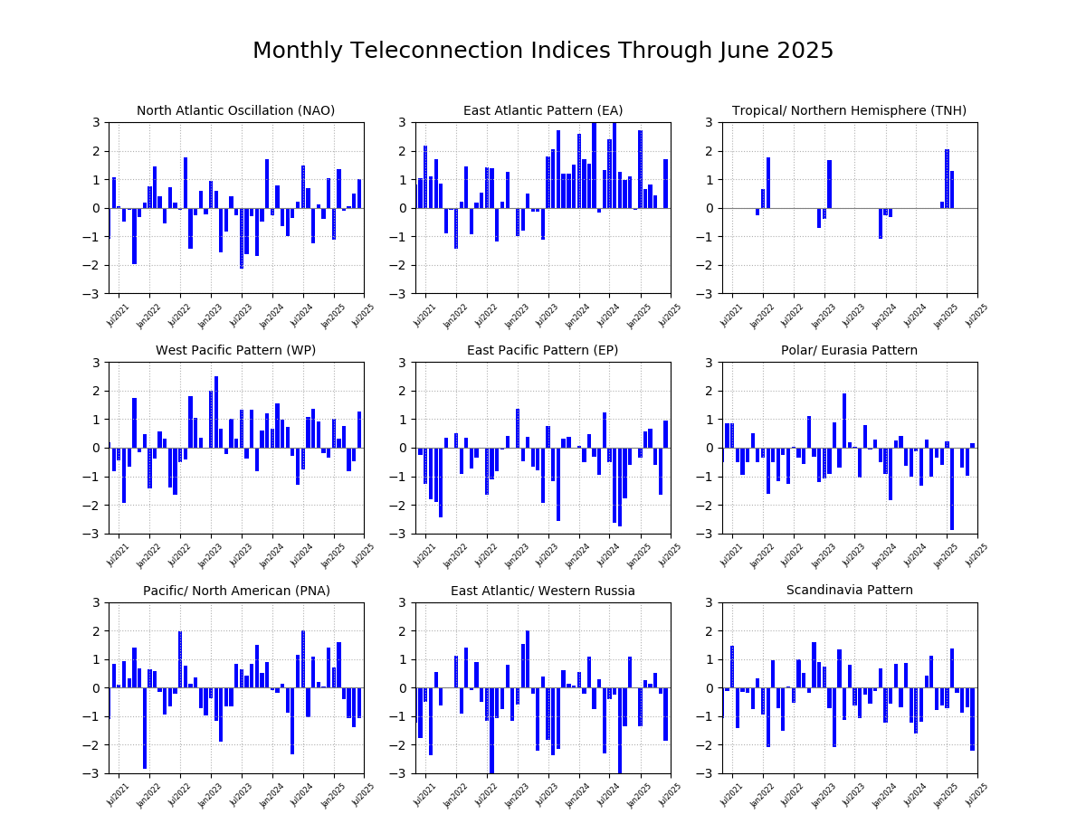
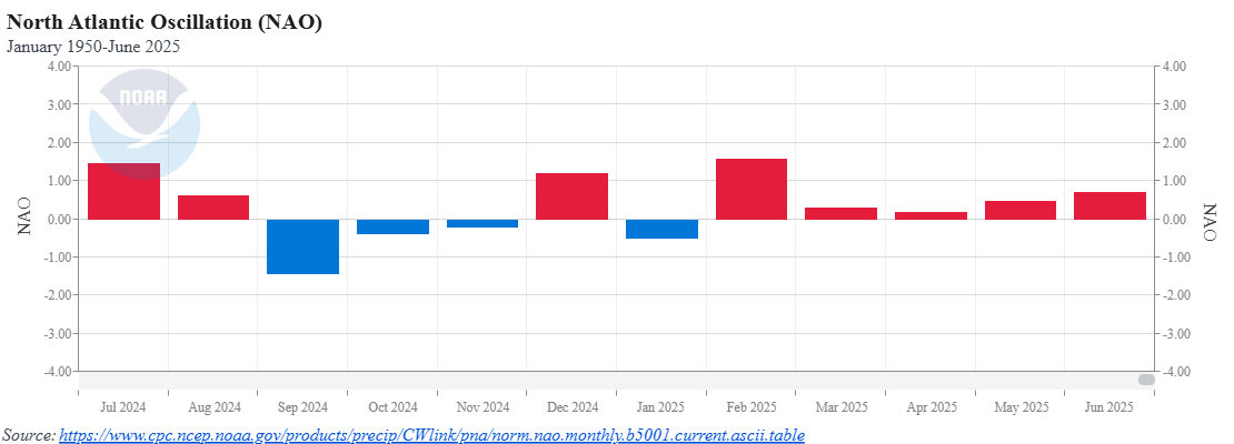
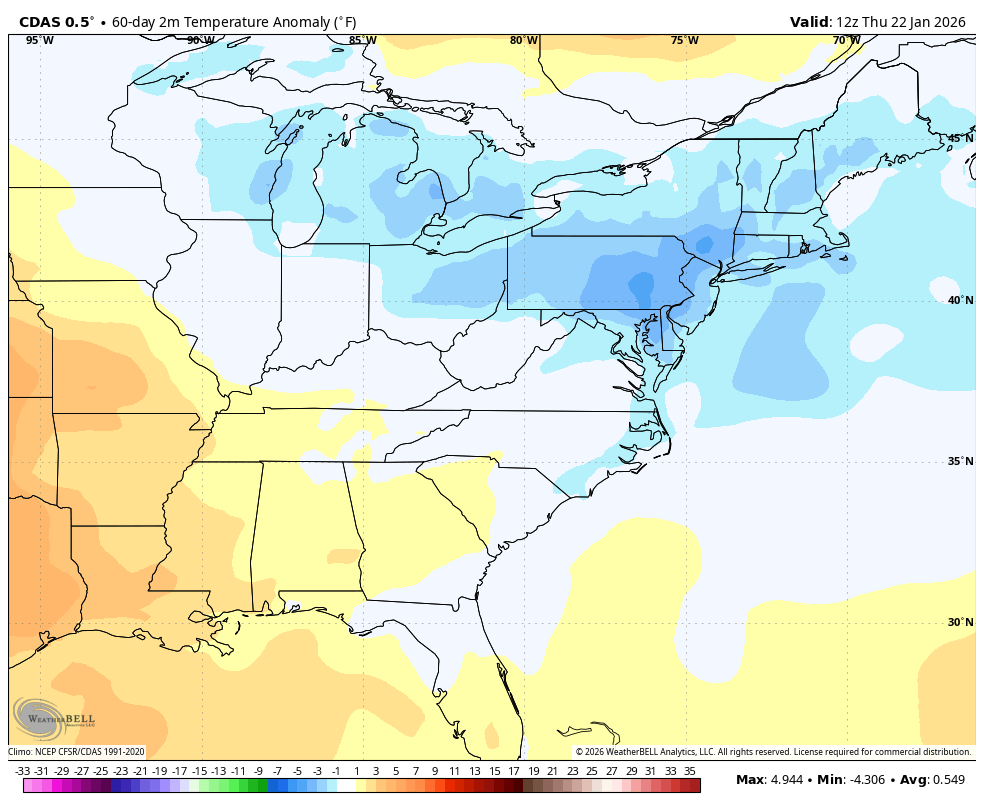
The overall weather pattern so far this winter has been dominated by a trough of low pressure centered over the Great Lakes with ridging taking place across either the Southeastern U.S. or the Rockies. The eastern troughs have expanded and contracted as the polar vortex has expanded and contracted this winter season. This has led to colder than normal temperatures from the Great Lakes to the Northeast since the middle of November, although there was a brief thaw back in early January. In addition, this pattern has resulted in weather systems generally moving into the region from the west or northwest. This is has led to some fairly frequent snow events through the winter but none of them have had much moisture to work with, so snowfall has generally been on the light side, except for lake-effect events. This has been due to the storms originating in areas with not a lot of moisture limiting the potential snowfall from them.
The pattern is in the midst of a change as there’s been a major expansion of the polar vortex over the last week. This is going to result in a deep trough developing over the eastern half of the country over the next few weeks. The pattern is shifting to one where colder airmasses will be moving into the region on a regular basis through early February. These airmasses will also be settling further south on a more regular basis over the next couple of weeks. In addition, storm systems will start to develop along the arctic boundary further south in the country which will allow these potential storms to tap into moisture from the Gulf of Mexico. In laymen’s terms, the pattern is becoming much more dynamic and our exposure to heavier snowfalls is increasing quite a bit over the next 2-3 weeks, especially in comparison to what we’ve seen so far this winter.
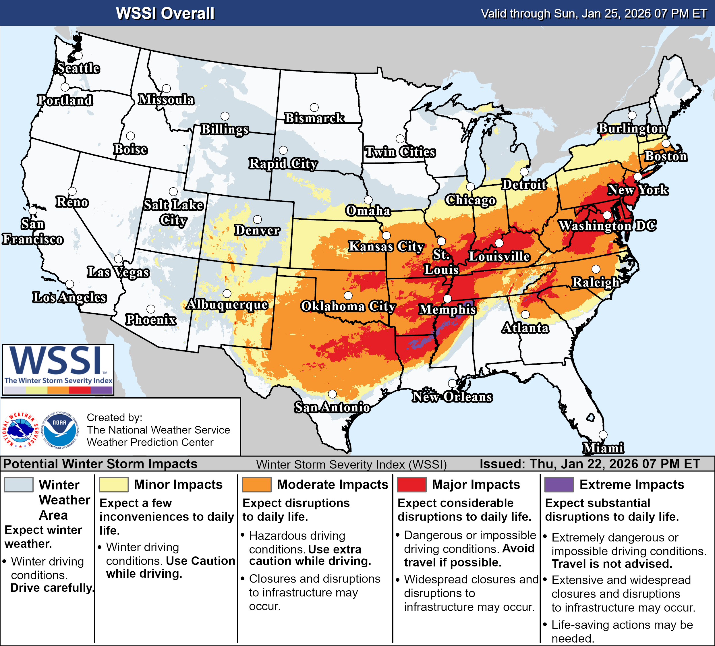
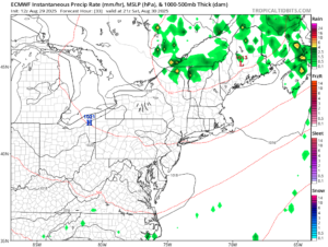
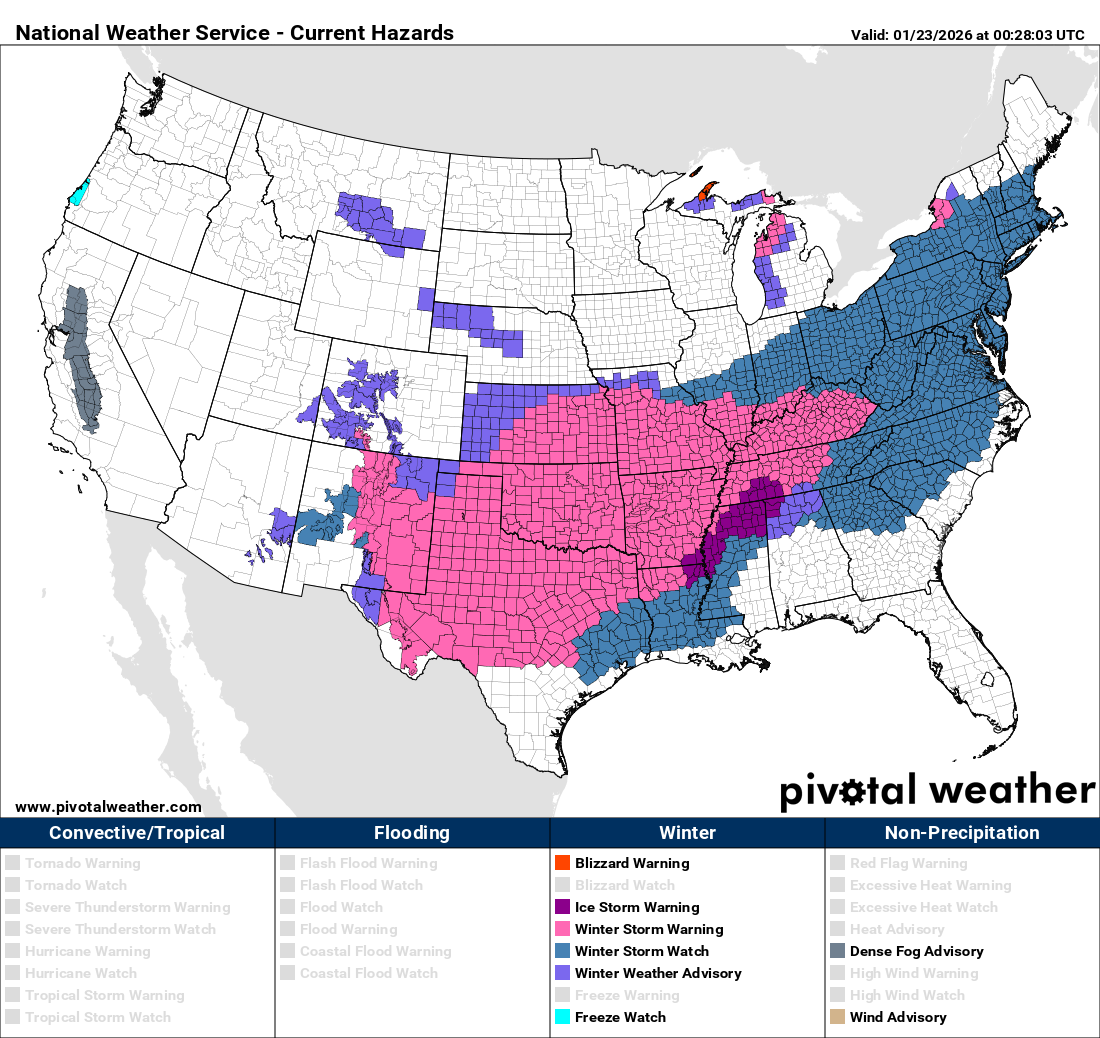
That starts over the next few days as arctic air pours into the nation while a low pressure system moving out of the Southwest encounters that colder air. It will draw moisture northward from the Gulf, and as it encounters that colder air at the surface, it will fall as freezing rain in a large swath from parts of Texas and the Southern Plains across the Tennessee Valley and into parts of the Southeast and Mid-Atlantic states. Some significant ice accretions are possible from parts of northeastern Texas and southern Oklahoma across Arkansas, northern Mississippi, Tennessee, and Kentucky, into the Carolinas and Virginia, beginning later Friday in western parts of this region, late Saturday as you head toward the Carolinas. Just to the north of these areas, where the cold air is a little deeper, some significant sleet is possible, especially in parts of Oklahoma and Arkansas. This will be a long duration storm, with precipitation likely not ending until Sunday for much of this region. This will likely cause widespread travel disruptions and power outages, with extended recovery times expected.
Farther north, heavy snow will be widespread north of the track of the low pressure system from the Southern Plains to the Ohio Valley. Many locations could pick up a foot or more of snow. Across the eastern Great Lakes, the snow will be enhanced by lake-effect snow as the arctic air moves in. Areas downwind of Lake Ontario could see totals upwards of 2-3 feet.
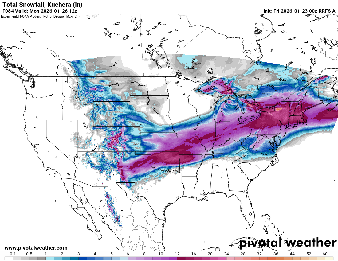
As the system moves to the East Coast, things become a little more complicated. The storm will strengthen, but the exact track it takes has a big impact on what type of precipitation falls, and how much accumulates. Right now, it looks like snow will change to sleet and freezing rain Saturday night and early Sunday across much of Virginia and the Delmarva Peninsula, including the Washington and Baltimore areas, with plain rain right along the coast. This will keep snow accumulations significantly lower. The changeover should get into the Philadelphia area and parts of New Jersey as well Sunday evening, which would result in lower accumulations. To the north, moderate to heavy snow is expected in parts of New York and central and southern New England, but again, a track farther north could bring sleet and/or rain into parts of Long Island and southern New England, possibly into New York City as well. Up here, snow won’t even begin in New York until daybreak Sunday, and in parts of southern New England until later Sunday afternoon or evening. Precipitation won’t end in these areas until sometime on Monday, possibly Monday night or early Tuesday in eastern New England. Once again, in places where precipitation falls as all snow, many areas will pick up a foot or more.
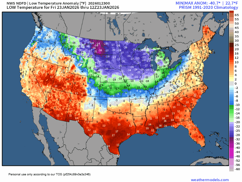
Another surge of arctic air will settle in behind this storm across parts of the nation’s mid-section by the end of the weekend, and into the East early next week. As mentioned above, this pattern is likely to remain in place through the rest of January and into at least early February.