People across the United States are preparing for the upcoming winter season. Some areas, especially in the north and at higher elevations, have already experienced their first snowfall of the season. Many areas across the eastern United States will experience what is likely the coldest weather of the year so far, as a low-pressure system brings cold arctic air to the region.
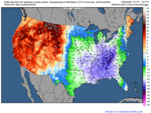
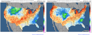
Arctic air will send temperatures plummeting across the eastern half of the United States. Image provided by Weather Models.
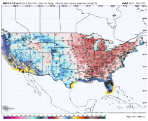
A cold front sweeping across the eastern half of the United States will pull arctic air out of Canada as it moves east, causing temperatures to plummet. Areas near the Appalachian Mountains could experience afternoon high temperatures more than 30 degrees below normal on Monday, with record lows possible on Tuesday morning across the southeastern United States.
The cold air will allow for record-breaking temperatures across the Southeast on Tuesday morning. Image provided by Weatherbell.
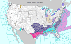
Freeze warnings are in effect for some places across the region, meaning these sub-freezing temperatures could damage, or even kill, crops and other sensitive vegetation. When a freeze warning is in effect, it is recommended that anyone affected take precautionary measures to protect these sensitive plants. Fortunately, these cold temperatures will only be around for a short time across the Southeast. High pressure is expected to move over this region by the middle of the week, allowing temperatures to stabilize and possibly even shift above normal through the end of the week.
Freeze warnings are in effect for areas in the Southeastern United States. Those within the warning area should take steps to ensure the safety of sensitive plants and vegetation. Image provided by the National Weather Service.
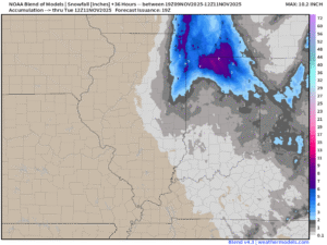
In the north, a low-pressure system will bring rain and snow from the Great Lakes to the Northeast. During this time, areas in the Great Lakes will experience their first Lake Effect event of the season. An upper-level wave will swing around behind the larger low-pressure system, bringing snow to most areas in its wake. Communities along the south shore of Lake Michigan will experience the highest snowfall totals from this system, with several inches of snow possible in some areas.
Several inches of snow are expected to fall in Northwest Indiana, along the coast of Lake Michigan, due to a Lake Effect snow event. Image provided by Weather Models.
This disturbance will also keep things unsettled across the Northeast as it moves offshore around the middle of the week, with snow showers possible each day in Northern New England and Upstate New York. Another system following behind will bring a continued chance for snow and rain showers across the region through Thursday, before high pressure eventually moves in toward the end of the week.
The pattern will remain unsettled across the Northeast for much of the week as a series of systems and smaller disturbances move through the region. Loop provided by Tropical Tidbits.
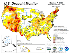
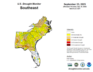
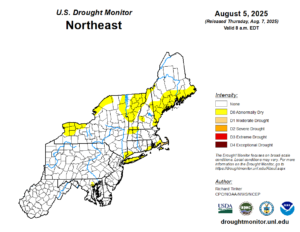
After several weeks of mainly dry weather from the Mid-Atlantic to the Northeast, many areas are experiencing abnormally dry to drought conditions, with some areas even seeing an extreme drought. A developing low-pressure system could bring some relief to areas.
Dry weather over the last several weeks has caused most of the Eastern U.S. to become dry, with some areas even experiencing extreme drought conditions. Image provided by the National Drought Mitigation Center.
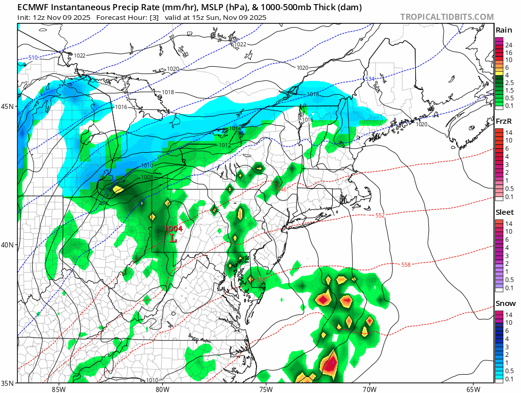
A system is developing off the coast of the Southeastern United States and is beginning to move north. At the same time, another smaller system is moving out of southern Canada and through the Great Lakes. By the end of the weekend, these two systems will combine near the Mid-Atlantic and progress toward New England.
A small low-pressure system will combine with a larger system in the Atlantic, then strengthen, bringing gusty winds and heavy rain from the Delmarva Peninsula to New England. Loop provided by Pivotal Weather. (Click for loop)
As this system strengthens, it will bring the potential for strong and gusty winds from the Delmarva Peninsula to the southern coast of New England through the beginning of the week. This region still has most of its leaves on the trees, so these gusty winds could bring down the heavy trees, resulting in more widespread power outages.
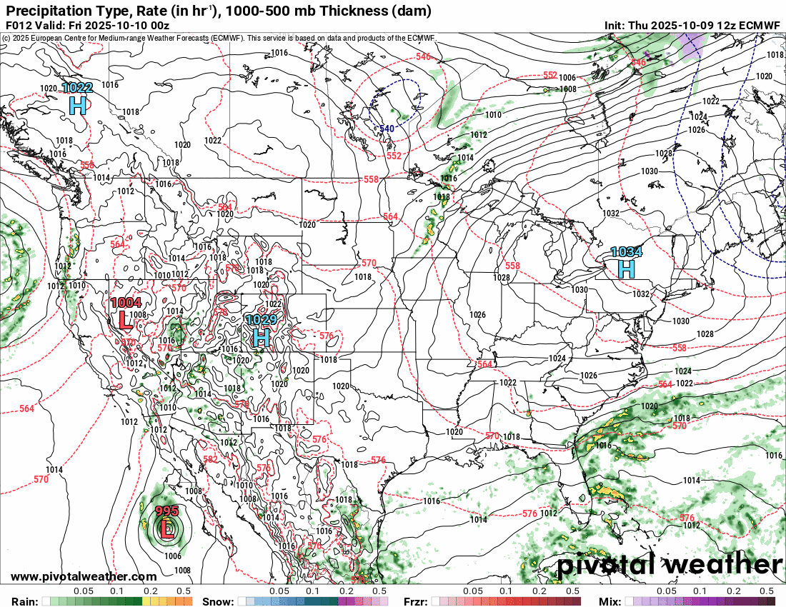
A coastal storm is expected to bring strong winds to coastal areas in the Northeast and Mid-Atlantic. Loop provided by WeatherBell.
This system is also expected to bring heavy rain across the region. While much of the region is experiencing a drought and desperately needs rain, some areas, especially those closer to the coast, are at a higher risk of flooding. The greatest potential for flooding will be between Sunday afternoon and Monday night, with coastal flood watches and advisories already in effect spanning southern New England and the Mid-Atlantic. In combination with the highest rainfall totals near the coast, tides are still running higher than usual from the astronomical high tides that occurred earlier this week. Strong winds will also contribute to the formation of large waves offshore, creating a long fetch. The persistent east and northeast flow will allow these large waves in the long fetch area to move onshore, posing a greater threat to flooding in coastal areas, especially from Cape Cod to the northern Mid-Atlantic through Monday evening.
Areas closer to the coast from Massachusetts to Delaware are expected to receive the heaviest rainfall from this system, leading to the potential for flooding. Image provided by Weather Models.
Impacts will begin to diminish Monday night as the system starts to pull away from the region before high pressure builds in behind over the Northeast and Mid-Atlantic, allowing for drier weather through at least the middle of the week.
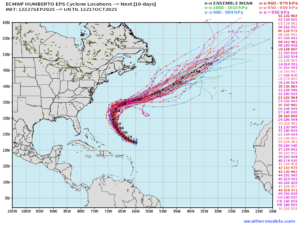
While the 2025 Atlantic Hurricane season has remained relatively quiet, things are starting to ramp up as we end September. Hurricane Humberto, now a Category 5 storm, will continue on a northwest track before turning northeast toward the beginning of the week. The storm will travel between Bermuda and the eastern United States coast, while remaining over open waters as it progresses into the Northeast Atlantic.
Humberto will remain over open waters as it moves northwest before turning northeast near the beginning of the week. Image provided by Weather Models.
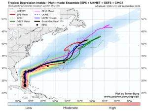
Another disturbance being monitored near Haiti and the Bahamas has been named Tropical Storm Imelda, with strengthening expected to continue through the start of the week as it becomes more organized. This system will progress north, toward the Carolinas, where areas are still recovering from the devastation brought by Helene just one year ago.
Tropical Storm Imelda will progress north-northwest, where it will interact with a stalled front. These two systems will contribute to heavy rainfall across the Carolinas. Image provided by Tomer Berg.
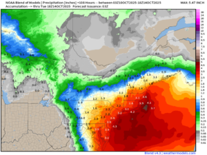
A frontal system moving off the East Coast will remain stalled, allowing rainfall to continue through the next several days. As Tropical Storm Imelda moves north, it will interact with the stalled front, then turn east and remain out at sea. Areas closer to the North and South Carolina coasts will have the highest chance of significant rainfall from these systems, with higher totals also possible locally, especially in higher terrain.
Areas of North and South Carolina could see several inches of rain as a result of a stalled front and a tropical system in the Atlantic. Image provided by Weatherbell.
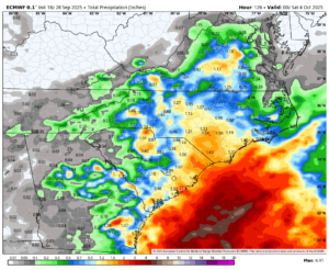
Much of this area is currently experiencing abnormally dry to moderate drought conditions, so many residents in this area are hoping for relief, but that will likely not be the case. When heavy and excessive rainfall occurs, especially in regions experiencing drought, the ground struggles to absorb the water at the rate at which it is falling. This, in turn, will cause flooding, which can be extreme and catastrophic, especially in areas still recovering from previous flooding events.
Most areas of North and South Carolina need rain, but excessive rainfall in a single event can lead to catastrophic flooding. Image provided by the National Drought Mitigation Center.
Many families across the United States will be trying to squeeze in one last summer activity this weekend, as Labor Day marks the unofficial end of the summer season. Fortunately, many areas will experience sunshine and dry weather as high pressure dominates the majority of the pattern across the country, while others may not be so lucky.
A large stalled front will bring rain to much of the Gulf Coast and Southern Plains through the weekend, with heavy rainfall expected. Flash flooding will be a concern for eastern New Mexico, central and western Texas, and the Central Plains on Saturday, while west and central Texas, as well as southern New Mexico, remain at risk for flooding through Sunday. Showers could also spread into the Tennessee Valley on Monday as the front remains stationary.
Heavy rain in association with a stationary front could bring the potential for flash flooding to areas across the central and southern United States on Saturday, and is expected to continue on Sunday, especially in New Mexico and Texas. Images provided by the Weather Prediction Center.
The front will also extend into the Rocky Mountains, bringing showers and thunderstorms to start the weekend. A warm front will break off and progress east on Sunday with a low pressure system moving across the northern part of the country. Areas in extreme eastern Nebraska could be at risk for flash flooding as this system begins progressing east. Temperatures will average well below normal ahead of this system and return to near normal on the backside.
Temperatures will average mainly below normal across the country on Sunday, with values expected to be well below normal in the Plains ahead of a warm front moving out of the Rockies. Image provided by Weather Models.
A cold front in association with a low pressure system slowly moving into Atlantic Canada will extend into the Mid-Atlantic and Tennessee Valley on Saturday, allowing for some extra cloudiness across the region. This system will also send disturbances through the Northeast, bringing an increase in clouds during each afternoon, especially on Saturday. Areas in extreme northern New England may also see a stray shower or two, particularly in the afternoon as the disturbance moves through.
A disturbance will bring the potential for showers and thunderstorms to northern New England on Saturday afternoon, while high pressure keeps the rest of the Northeast dry. Image provided by Tropical Tidbits.
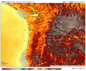
Areas along the West Coast will experience dry weather through the weekend, with temperatures averaging near normal to start the weekend, then shifting above normal toward the end of the weekend, with extreme heat possible, especially in interior areas.
Temperatures will soar into the upper 90s across western Washington, with some areas potentially reaching values close to 100. Image provided by WeatherBell.
Looking at the week ahead, things are expected to remain relatively quiet. Areas across the Central U.S. will continue to see well below normal temperatures ahead of a slow moving warm front. Areas in the west, specifically in the Pacific Northwest, will continue to see above average temperatures, where hot temperatures are expected to continue through the remainder of the week. There are no active storms in either the Atlantic or the Pacific; however, some areas are being monitored for potential development as the week progresses.
Disturbances in the Atlantic and Pacific are being monitored over the next week, where environmental conditions could support the development of tropical systems. Images provided by the National Hurricane Center.
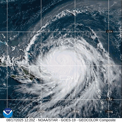
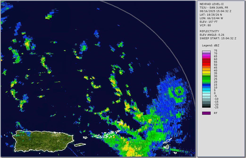
Hurricane Erin is pulling away from Puerto Rico and the Virgin Islands, but remains a powerful storm.
Hurricane Erin is passing north of the Dominican Republic this afternoon. Loop provided by NOAA.
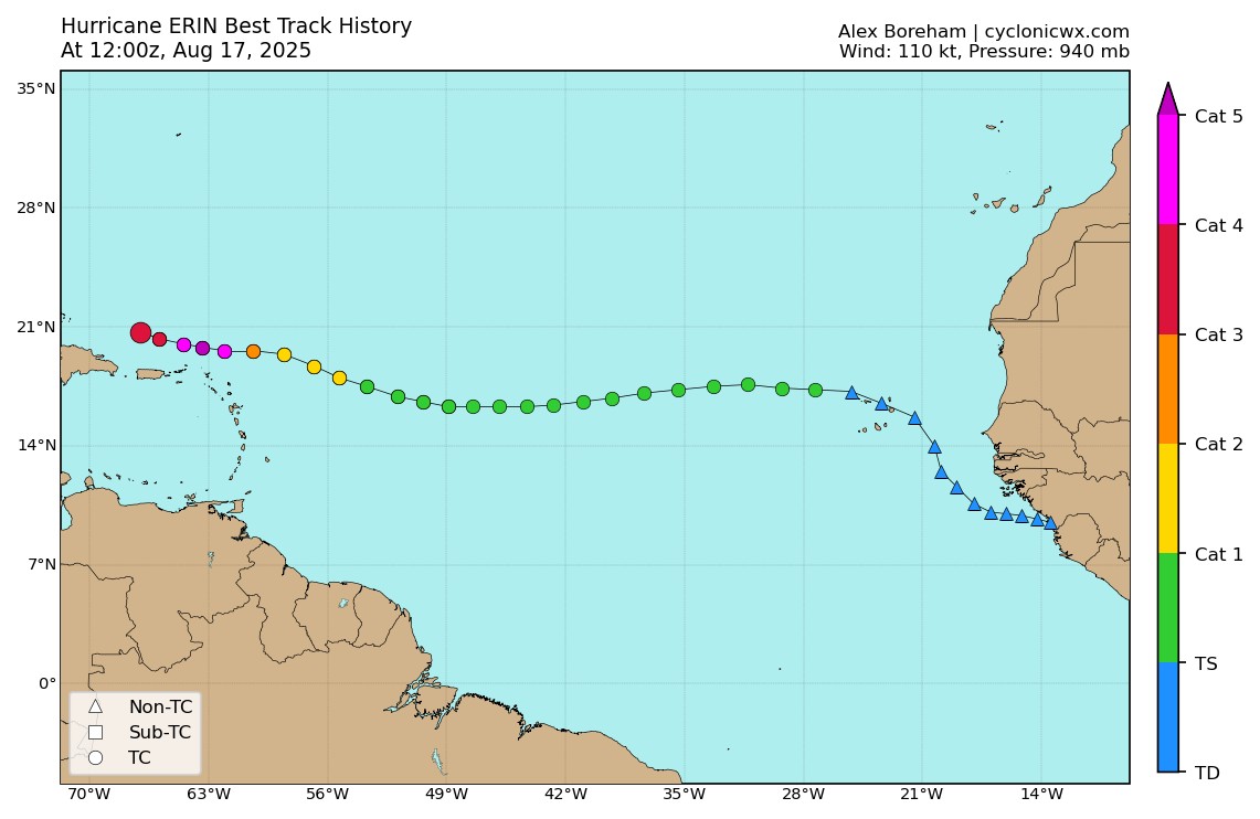
A tropical wave that moved off the west coast of Africa last weekend developed into Tropical Storm Erin as it crosses the Cabo Verde Islands on Monday. For much of last week Erin quickly crossed the tropical Atlantic, fighting off dry air from Saharan Dust and cooler sea surface temperatures while slowly gathering strength. By midday Friday, Erin finally had strengthened into the first hurricane of the 2025 season, about a week later than average date for the first hurricane of the year. Erin quickly made up for lost time though, taking advantage of favorable conditions to explosively develop into a Category 5 hurricane on Saturday, just the 43rd Category 5 storm on record in the Atlantic, dating back to 1851, the 9th one to form before September 1.
We’ve been tracking the system that became Erin since it moved off the coast of Africa. Image provided by CyclonicWx.
The center of Erin passed about 150 miles north of the Virgin Islands and Puerto Rico on Saturday, but the outer bands of the storm brought adverse conditions into the Virgin Islands. Observations from the British Virgin Islands indicate that over 9 inches of rain fell in about 18 hours on Saturday, along with wind gusts in excess of 60 mph. In the United States Virgin Islands and Puerto Rico, rainfall totals of up 5 inches resulted in flooding in many areas, with wind gusts to 50 mph resulting in downed trees and power lines.
Radar loop from Puerto Rico showing the passage of Hurricane Erin. Loop provided by Brian McNoldy, Univ. of Miami, Rosenstiel School
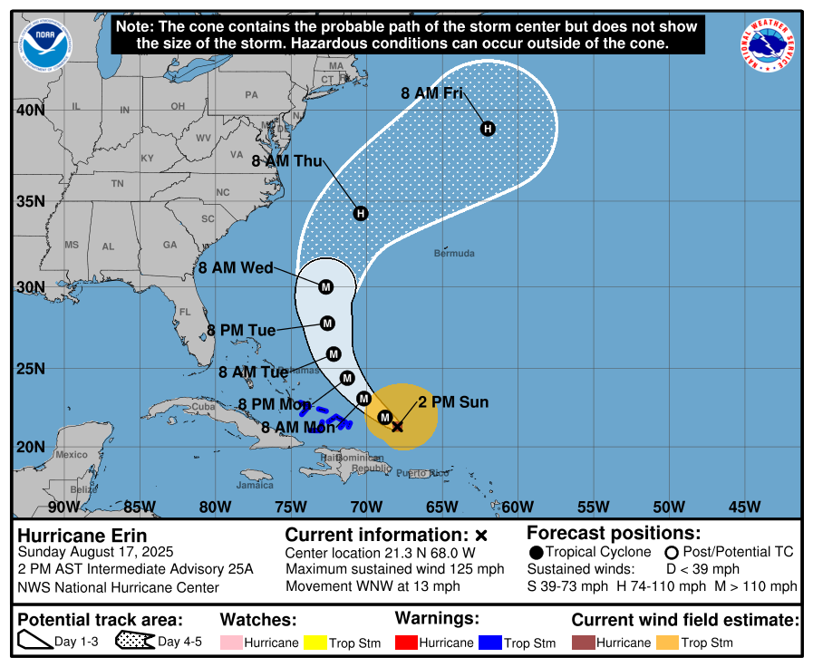
As of 2pm Sunday, Erin was still a Category 3 hurricane was maximum sustained winds near 125 mph, down from its peak of 160 mph on Saturday. Erin was centered about 200 miles east of Grand Turk Island, moving toward the west-northwest at 13 mph. Tropical Storm Warnings are in effect for the Turks and Caicos Islands as well as the southeastern Bahamas.
Forecast track for Hurricane Erin. Image provided by the National Hurricane Center.
The forecast for Erin is fairly simple at this point. Erin is expected to turn more toward the northwest and then north over the next day or two as it reaches the western edge of a ridge of high pressure. This will turn the storm away from the Bahamas and the East Coast, while also passing west of Bermuda. Erin may restrengthen a little, but it will also become a much larger storm. As a result, some of the outer bands of the storm could bring some squally weather to parts of the Bahamas and Turks and Caicos Islands today and Monday, and possibly to Bermuda and the Outer Banks of North Carolina towards mid-week. Erin should turn more toward the northeast during the latter half of the week, heading out into the open Atlantic well southeast of New England and Nova Scotia.
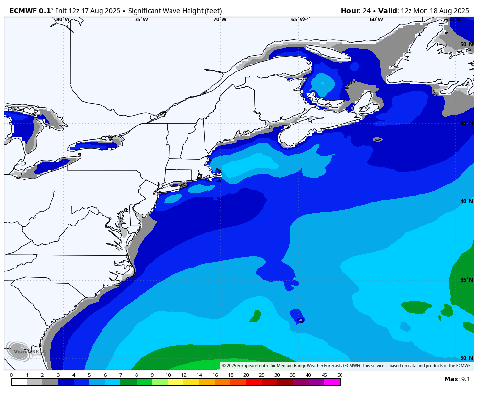
Hurricane Erin will generate large waves and rough surf for much for the East Coast this week. Loop provided by WeatherBell.
Erin will generate rough surf and large waves for much of the East Coast for a good chunk of the upcoming week, increasing the threat of riptides for much of the region. With a new moon next weekend, tides will be astronomically high later this week, so coastal flooding could be an issue near high tide across parts of the Northeast US and Atlantic Canada.
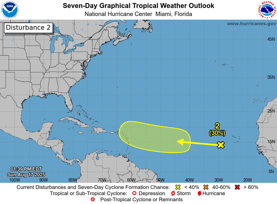
Another system in the eastern Atlantic has some potential to develop later this week. Image provided by the National Hurricane Center.
As we head towards the peak of Hurricane Season there will be more systems to watch, and we already have another one to keep an eye on. A tropical wave is producing disorganized showers and thunderstorms near the Cabo Verde Islands today. It will quickly head westward across the Atlantic this week. Conditions are not that favorable for development at this time, but could improve later this week as it gets into the central Atlantic. Some of the forecast models do show this system developing later in the week, so we’ll keep an eye on it this week.
August typically brings a range of weather conditions to the United States, from excessive heat to tropical systems and everything in between. As we move into the middle of the month, we are beginning to see this play out.
This weekend will bring dry and warm weather to much of the country. Many areas are expected to experience above-normal temperatures on Saturday. In contrast, others, including the Mid-Atlantic, Southeast, Intermountain West, and North-Central Rockies, are expected to experience below-normal temperatures. A cold front moving into the center of the country on Saturday will allow temperatures to dip below normal across the Central Plains on Sunday. Temperatures will also shift above normal on Sunday in interior areas of the Pacific Northwest as high pressure builds in across the region.
Temperatures average mainly above normal through the weekend across much of the country, with below normal temperatures in the Intermountain West, Southeast, and Mid-Atlantic. Images provided by Weathermodels.
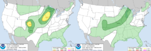
A cold front moving across the central United States will bring a marginal risk of severe weather to the Upper Great Lakes and Central Mississippi Valley, as well as the Central and Southern Plains, through the weekend. The highest risk for severe storms will be on Saturday, with a slight risk of severe weather across southwestern Wisconsin, southeastern Minnesota, northeastern Iowa, and eastern Colorado.
There is a slight risk of severe weather on Saturday for the Upper Midwest and eastern Colorado, with a marginal risk through the weekend from the Upper Midwest to the Southern Plains. Images provided by the Storm Prediction Center.
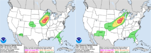
The cold front will also bring heavy rainfall to the Upper Midwest. There is a moderate risk of excessive rainfall across southwest Wisconsin, eastern Iowa, northwestern Illinois, and northeast Missouri on both Saturday and Sunday, with a slight risk extending from southern Wisconsin to eastern Kansas. A stationary front will continue to produce rain and thunderstorms across much of the Southeastern United States, with a marginal risk of excessive rainfall on both days. Meanwhile, in the Southwest, monsoonal moisture will bring showers and thunderstorms to the region with a marginal risk of excessive rainfall for both Saturday and Sunday.
The Upper Midwest will face the highest risk of excessive rainfall through the weekend, with areas such as the Southeast and Southwest also facing a marginal risk. Images provided by the Weather Prediction Center.
As we move into the beginning of next week, temperatures are expected to rise across the Northeast, with above-normal values anticipated for much of the week. The slow-moving front will bring showers and thunderstorms to the Midwest through the middle of the week before moving into the Northeast toward the second half of the week. The Northeast will see its next potential for rain as this front moves through, ending its dry stretch, which has caused some areas to become abnormally dry across the region.
Areas of the Northeast are becoming abnormally dry as the region continues to see dry conditions. Image provided by the National Drought Mitigation Center.
The stationary front across the south will continue to bring the potential for rain and thunderstorms to much of the region through the end of the week. Areas in the Southwest will also see the possibility of showers and thunderstorms each afternoon as monsoonal moisture remains over the region. Otherwise, high pressure will continue to bring dry weather to the majority of the country.
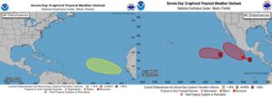
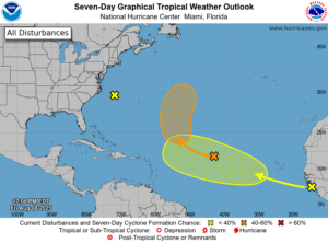
We will also be monitoring tropical development as the week progresses, since the National Hurricane Center continues to monitor areas in the Atlantic Ocean for possible development over the next seven days. Some models have been in favor of tropical development by the end of the week, but also show vastly different solutions for these systems. At this time, it is still too early to determine whether these storms will develop, never mind their storm tracks.
The National Hurricane Center is monitoring three areas for tropical development in the Atlantic over the next 7 days. Image provided by the National Hurricane Center.
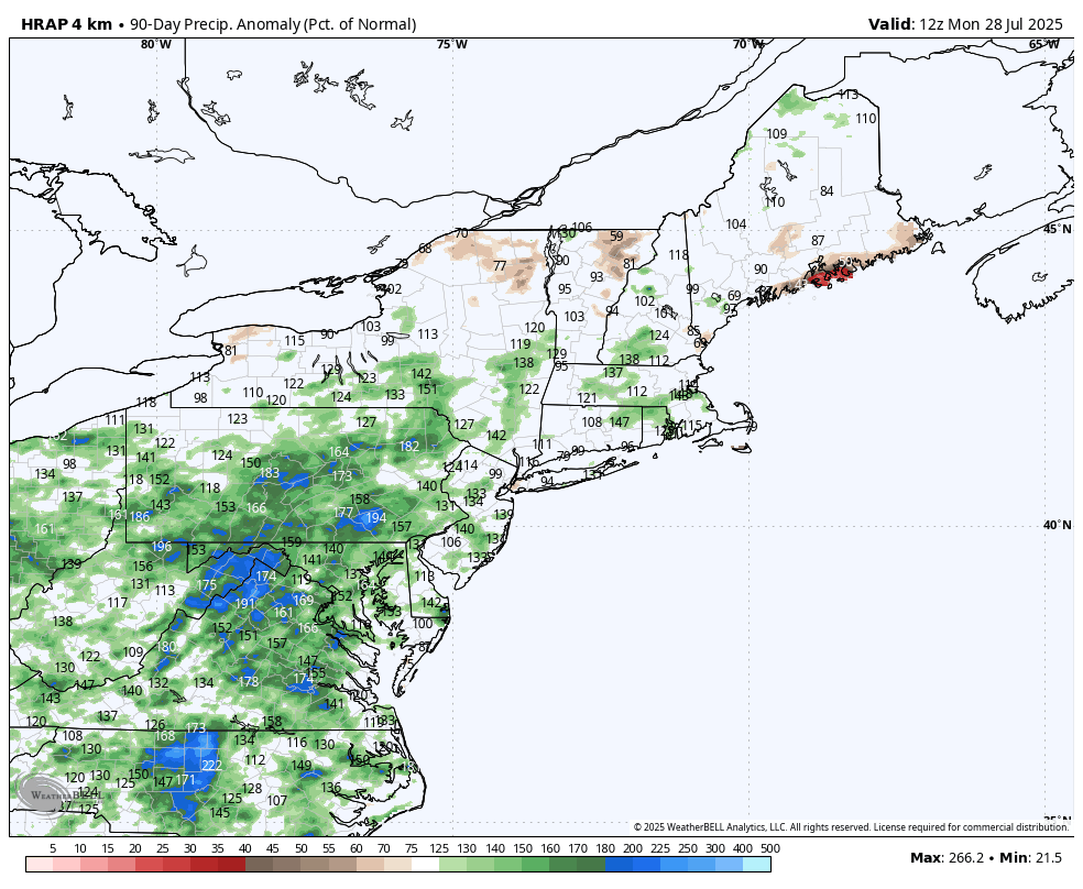
Over the past few months, there has been consistent troughing over the United States, particularly in the Great Lakes region, which has led to a stormier pattern across the eastern half of the country. One factor that can influence these changes in storm patterns and consistency is teleconnections.
Above to well above normal rainfall has been common across the Northeast over the past 90 days. Image provided by WeatherBell.
Teleconnections are relationships between specific weather phenomena at locations often separated by considerable distances. These phenomena are correlated with particular climate patterns spanning thousands of miles and exhibit variabilities ranging from days to years. Some of these patterns can also have more significant impacts during specific seasons, while others affect the climate pattern throughout the year.
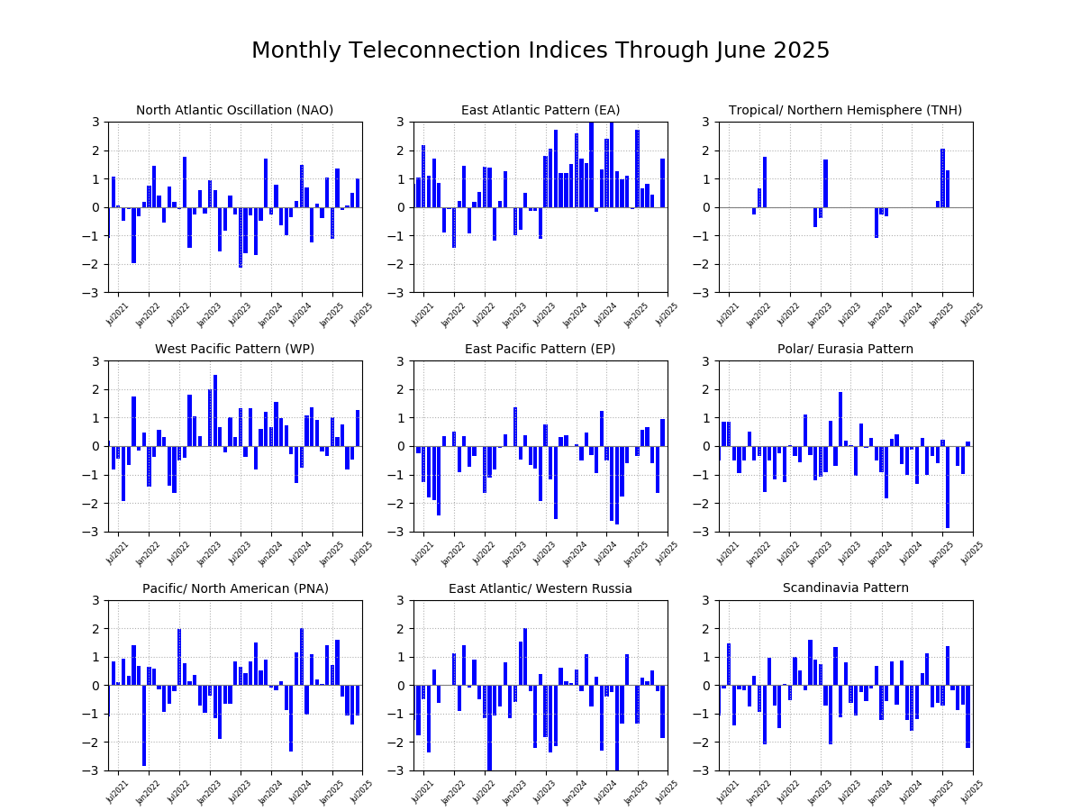
Many of the teleconnection patterns that affect the United Stated have been mostly positive since the start of the year. Image provided by the Climate Prediction Center.
Some of the major teleconnections and patterns that affect North America include the Arctic Oscillation (AO), El Niño/Southern Oscillation (ENSO), East Pacific Pattern (EP), North Atlantic Oscillation (NAO) , Pacific/North American Pattern (PNA), and Madden-Julian Oscillation (MJO). Patterns like ENSO will have a lesser impact on intraseasonal climate variability, as it can take several months to transition between phases. In contrast, the NAO will have a greater impact, as it can change between phases on a more regular basis.
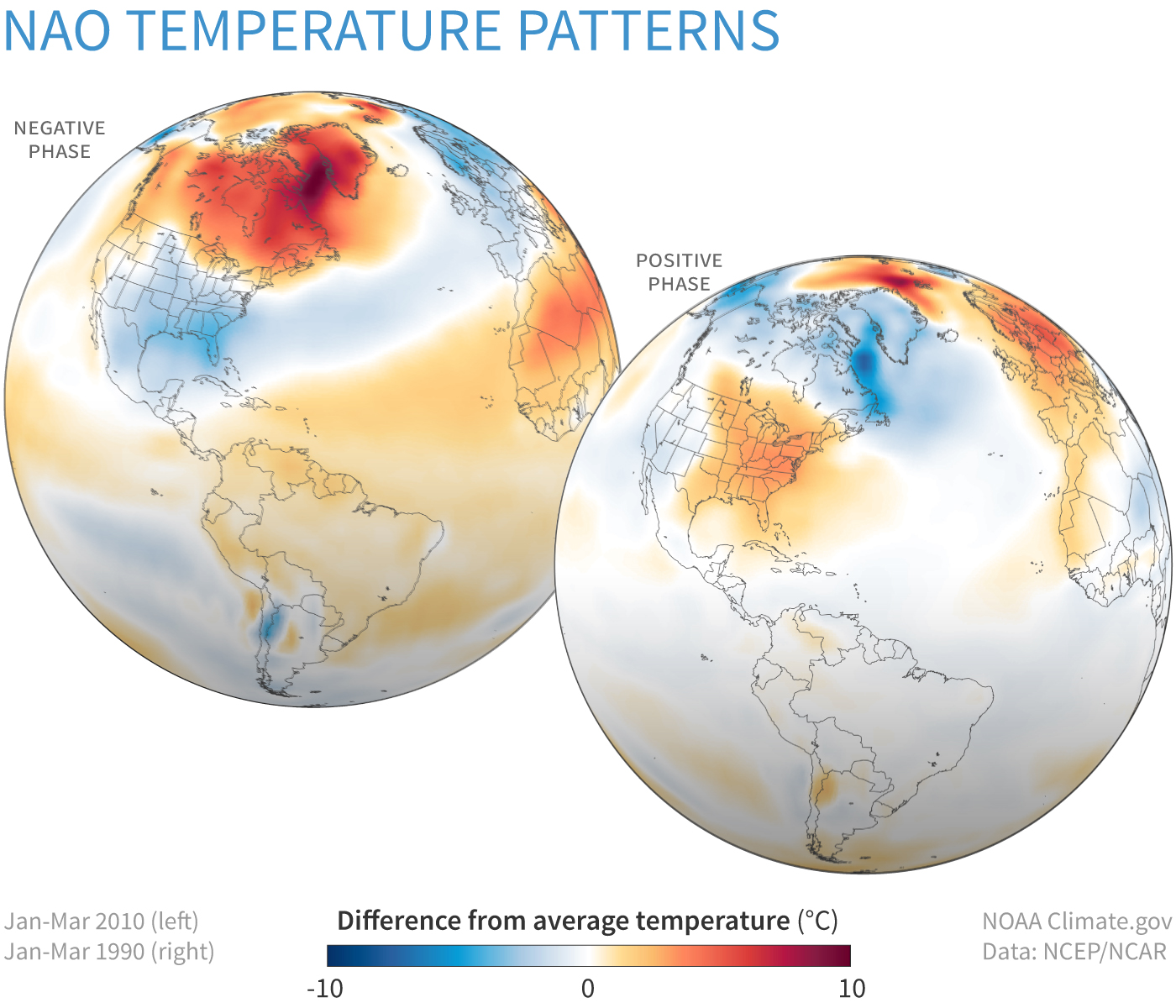
Temperature patterns for North America associated with the different phases of the North Atlantic Oscillation. Image provided by the Climate Prediction Center.
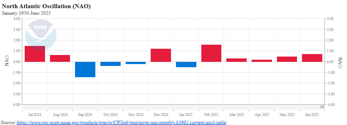
The NAO is an oscillation that impacts the climate pattern throughout the year. The positive phase will generally bring above-normal temperatures with a drier pattern to the Eastern United States, while the negative phase will produce the opposite. In the winter, a negative NAO usually leads to blocking over Greenland, and an increasing chance for more potent storms off the East Coast. The NAO has been mainly in the positive phase since early 2025. Although this may mean dry and warm conditions, the spring of 2025 averaged above normal for both temperature and precipitation across the eastern United States.
The monthly average of the NAO has been leaning positive since the beginning of 2025. Image provided by the National Center for Environmental Information
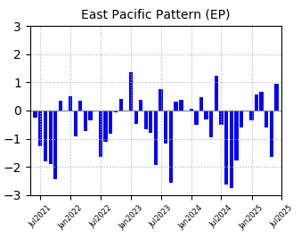
When examining other teleconnection patterns to identify the potential origins of the persistent unsettled pattern, it can be noted that the East Pacific Pattern transitioned into its positive phase in June, following a predominantly negative phase, especially over the past year. When the East Pacific Pattern is in its positive phase, the Eastern United States will experience more cyclonic activity, i.e., the persistent troughing we’ve been seeing across the Great Lakes and into the Eastern United States over the last several weeks.
The monthly average of the East Pacific Pattern shifted positive in June after leaning negative for the last year. Image provided by the Climate Prediction Center.
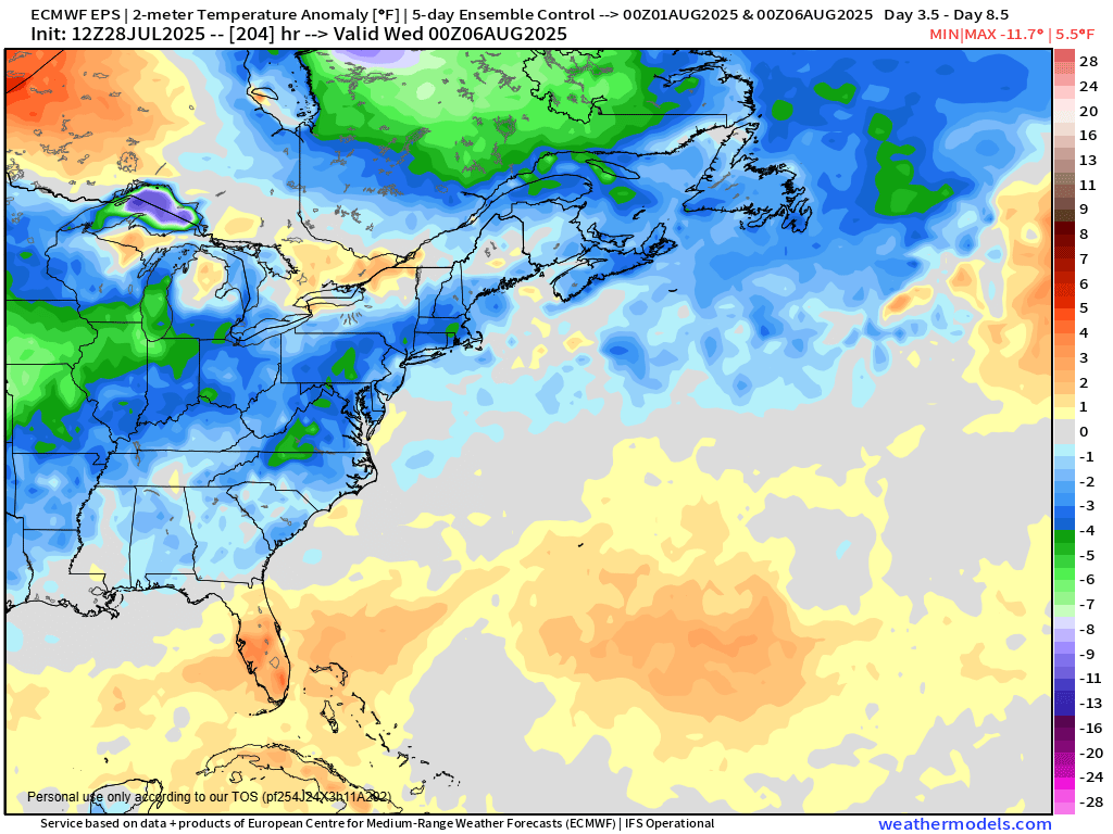
The stormy pattern is expected to continue across the East this weekend, as the NAO is expected to turn negative again, and a large trough of low pressure will settle into the Northeast. After a couple of hot and humid days for the first half of the week, a strong cold front will cross the region late Wednesday and Thursday before stalling out across the Mid-Atlantic states. Behind the front, temperatures will be as much as 5-10 degrees below normal for the end of the week and into the start of next week.
Much cooler weather will settle into the Eastern half of the nation this weekend. Image provided by Weathermodels.com.
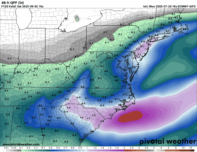
Along with the cooler weather, the potential exists for more heavy rain and flooding in parts of the Mid-Atlantic states and Northeast. As that front stalls out, a wave of low pressure will ride along it Thursday into Friday. With plenty of moisture in place in the tropical atmosphere south of the front, the wave of low pressure will produce heavy rain and thunderstorms. Some models show the potential for 3-6 inches or more of rainfall in spots in the span of 24-36 hours. Where the heaviest rain falls will be determined by where the front stalls out and the wave rides along it, which is still uncertain at this point.
Models are showing the potential for some heavy rain in the Northeast and Mid-Atlantic at the end of the week. Images provided by Pivotal Weather.
This pattern has the potential to produce other issues as we head deeper into the summer. The tropics have been mostly quiet thus far, but we’re approaching the time of year when activity ramps up. The bulk of storms in the Atlantic form between mid-August and mid-October. While many storms will end up recurving and heading out to sea before impacting the United States, an East Coast threat becomes a little more likely with an upper-level trough of low pressure in the Midwest or near the Appalachians.
As we begin the Independence Day holiday weekend, high pressure will bring dry weather to many areas of the eastern United States, while places out West could see unsettled weather. A frontal system will move east into the start of next week, bringing showers and thunderstorms across the northern and eastern half of the country. Hot and potentially dangerous temperatures are possible into the start of the week across the Midwest and Northeast. Eyes are on the waters off the Southeast, where tropical storm development is possible around mid-week.
Friday – Independence Day
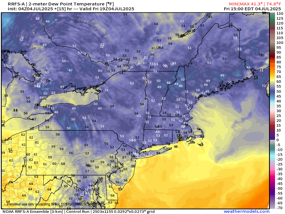
A cold front that has recently crossed the Northeast will provide perfect weather for the region, high pressure bringing sunshine and lower dewpoints, keeping humidity at a very comfortable level. High pressure will continue to dominate from the Great Lakes to the Gulf Coast, bringing sunshine to most of the Eastern United States.
Much drier air will move into the Northeast for Friday. Image provided by Weathermodels.com
Other areas of the Southeast will see the potential for rain as a low pressure near Florida allows the rain to continue. Remnants of the very short-lived Tropical Storm Barry will also bring the chance for rain and thunderstorms to most of Texas.
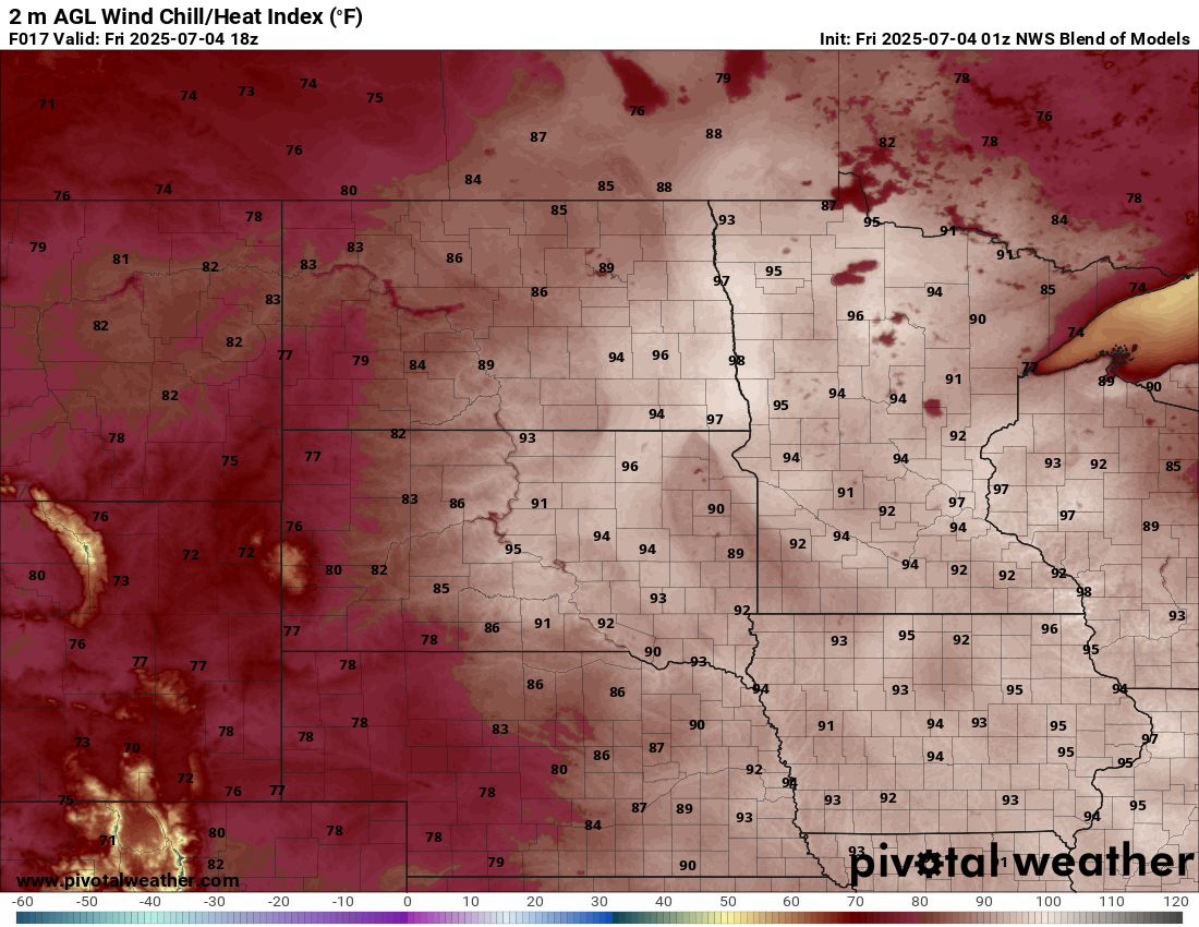
Hot and potentially dangerous temperatures are possible across the Upper Mississippi Valley and Northern Plains ahead of a cold front extending from a low pressure system in central Canada. This frontal system will bring rain and thunderstorms to the region, with a marginal risk of strong to severe thunderstorms.
Heat index Values for Friday across the Northern Plains. Image provided by Pivotal Weather.
Monsoonal moisture will produce showers and thunderstorms across parts of the Southwest, especially during the afternoon. A system in the Northwestern United States will bring showers with a chance of thunderstorms to the Pacific Northwest, Great Basin, and Intermountain West.
Saturday
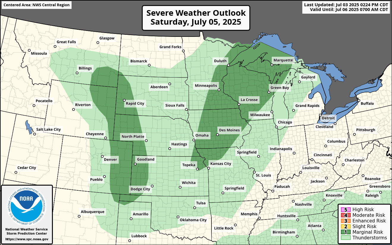
The hot temperatures will progress east as the frontal system moves across the northern United States, the marginal risk of severe weather continues across the Upper Great Lakes while also shifting to the central Mississippi Valley. The front will wrap up into the Central Plains as it converges with a weaker system in the Northwest, with a marginal risk of severe weather in the west-central Plains.
Severe weather outlook for Saturday. Image provided by the Storm Prediction Center.
The low pressure near Florida will bring another day of showers and thunderstorms to the state as moisture from Barry continues to sit over Texas, with more showers and thunderstorms possible.
Monsoonal moisture will allow the potential for afternoon showers and thunderstorms to return across the Southwest.
Sunday
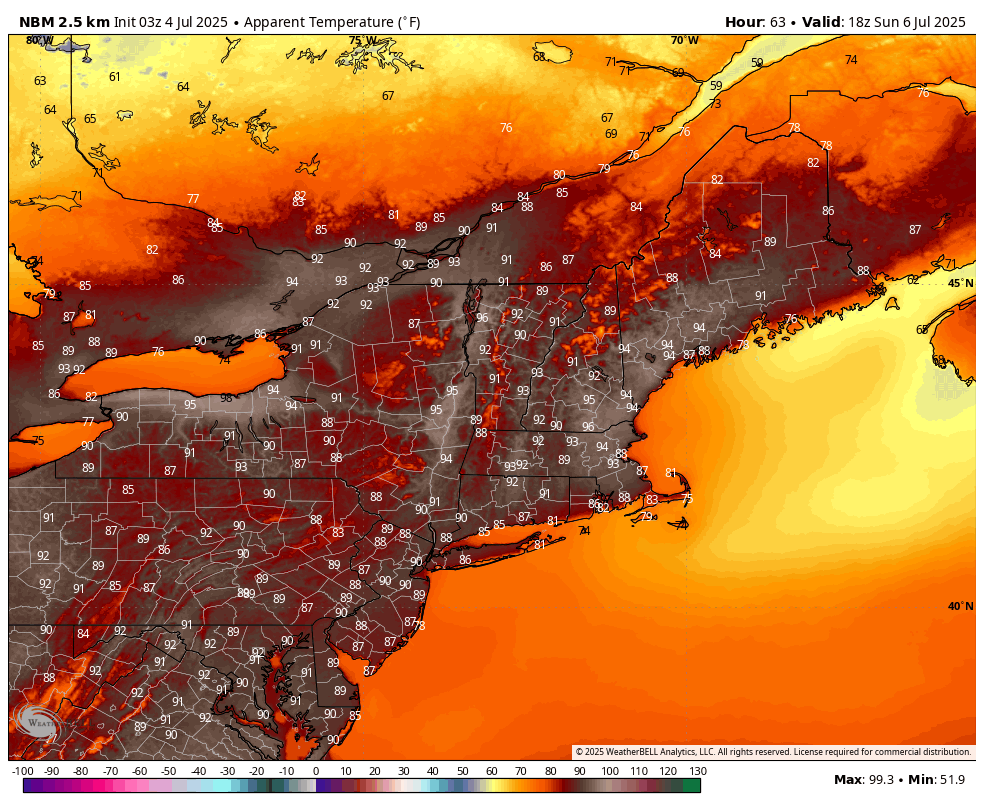
Showers and thunderstorms will begin to taper off across Florida as the low pressure system nearby slowly pulls away from the region and moves up the East Coast, bringing shower and thunderstorm activity into the Mid-Atlantic.
Hot and humid weather will return to the Northeast as the frontal system continues its eastward progression. Showers and thunderstorms are possible from the Great Lakes to the Southern Plains. The weaker system follows behind the main system, bringing the potential for showers and thunderstorms to the Central and Northern Plains.
Heat indices across the Northeast on Sunday. Image provided by WeatherBell.
Monsoonal moisture could potentially bring more showers and thunderstorms to the Southwest.
Monday through Friday
Hot and humid weather will continue across the Northeast on Monday as the frontal system continues its progression east with showers and thunderstorms possible from the Northeast to the Southern Plains. A weaker low pressure system following this system will continue to produce showers and thunderstorms through the Central Plains.
The low pressure system in the Southeast will continue its journey up the East Coast, allowing for the potential of showers and thunderstorms across the Mid-Atlantic. This system will begin to interact with the large frontal system on Tuesday, allowing the front to become stationary across the Tennessee Valley. The stationary front will produce showers and thunderstorms from the Ohio Valley to the Gulf Coast through the end of the week. These two systems will be monitored for tropical system development as they move offshore.
The East will be unsettled with the West turns drier next week. Loop provided by Pivotal Weather.
The smaller low pressure in the Central Plains will begin to weaken on Tuesday, allowing the shower and thunderstorm potential to diminish. Drier weather is expected through the middle of the week before another system develops toward the end of the week, bringing the potential for showers and thunderstorms.
Monsoon moisture will allow for the potential of afternoon showers and thunderstorms each afternoon.
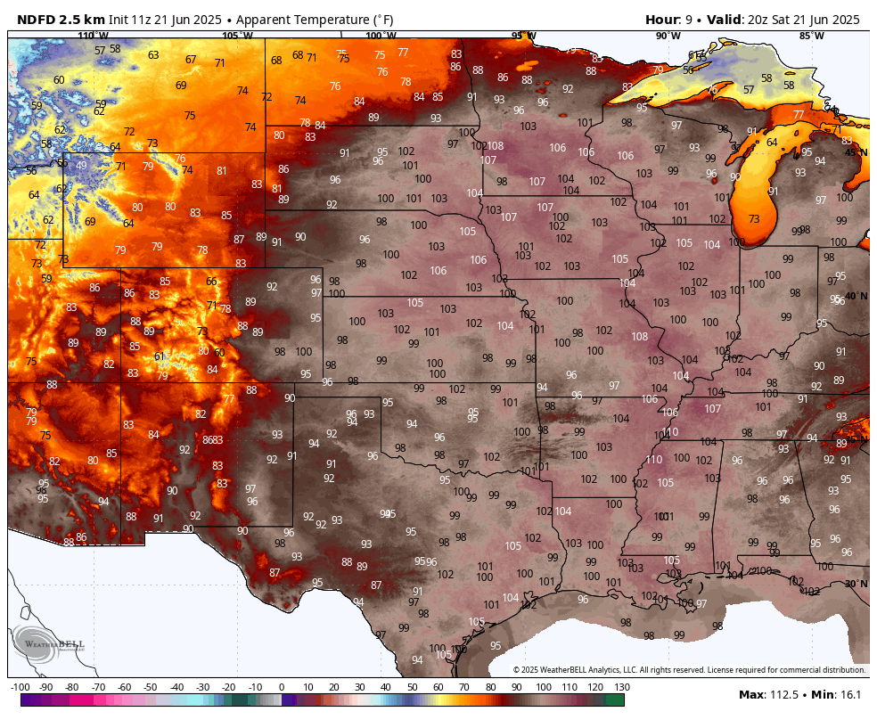
Hot and humid conditions are expected across the eastern half of the nation as we go through the first weekend of summer.
A ridge of high pressure brings heat and humidity to the eastern half of the nation over the next few days. Loop provided by Pivotal Weather.
A large ridge of high pressure centered over the Mississippi and Tennessee Valleys Saturday morning will slowly move eastward over the next few days, resulting in hot and humid conditions for a large portion of the nation. The heat and humidity are focused on the Plains States and Mississippi Valley to start the weekend with Heat Advisories and Extreme Heat Warnings in place from the Northern and Central Plains into the Mississippi Valley and the Midwest. High temperatures will reach the 90s in much of this region, with highs topping 100 in parts of the Northern and Central Plains, possibly setting records in a few spots. With dewpoints in the upper 60s and 70s, the heat index will reach 100 to as high as 110 in much of the region. The heat will continue into Sunday, with widespread highs in the 90s and lower 100s expected once again and heat indices in excess of 100, but an approaching cold front will produce showers and thunderstorms during the afternoon and evening, some of which could be strong to severe, bringing relief to the region.
The heat index will top 100 across much of the nation’s mid-section Saturday afternoon. Image provided by WeatherBell.
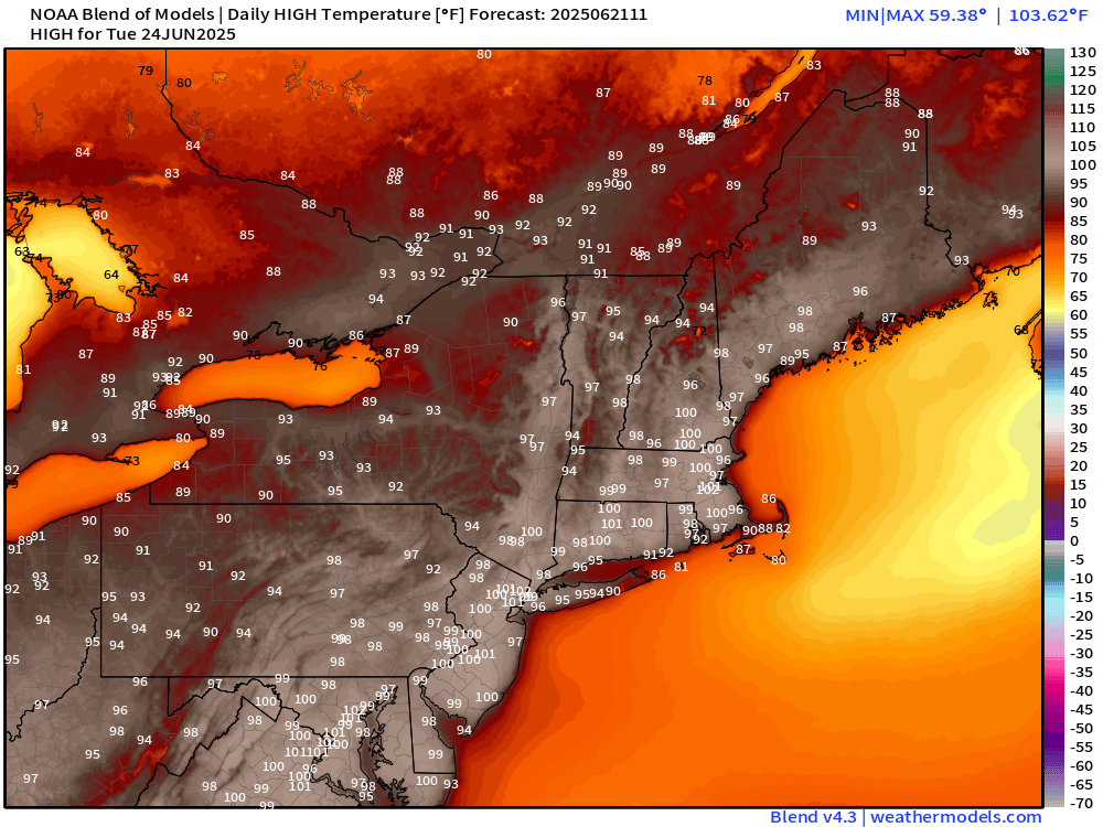
The heat and humidity will shift into the Great Lakes and Northeast on Sunday, with record highs expected in many areas as temperatures rise well into the 90s. Dewpoints will be climbing into the 60s and 70s, resulting in heat indices near or over 100. Heat Advisories and Extreme Heat Watches and Warnings have been issued for much of this region. As we head into the start of the new week, the focus of the heat will shift once again to the heavily-populated Interstate 95 corridor along the East Coast. High temperatures in the upper 90s to possibly lower 100s are expected on Monday in this area likely setting records in dozens of locations, more likely on Tuesday. When the humidity is factored in, the heat index will reach 105 to 110 degrees in many areas. Little relief is expected at night, as nighttime lows only drop into the 70s, with some of the urban areas possibly staying above 80. A backdoor cold front may bring some relief to parts of New England, possibly as far south as the New York City area on Wednesday, but heat and humidity will continue across the Mid-Atlantic states.
Temperatures could approach 100 across much of the Northeast on Tuesday. Image provided by Weathermodels.com
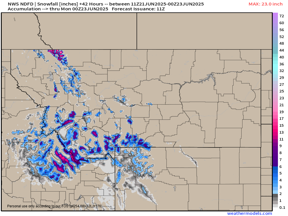
While heat is making headlines across the eastern half of the nation, in the Northern Rockies, a late-season winter storm is moving in. A storm system moving in will bring strong winds and heavy precipitation to the region today and into Sunday. Sustained winds of 30-40 mph with gusts in excess of 60 mph are expected in some areas. Across the higher elevations of western Montana and eastern Idaho snow levels have fallen as low as 5000 feet. Above that level, snowfall totals of 4-8 inches are expected by Sunday morning, with totals of 10-20 inches expected once you get above 6000 feet. Winter Storm Warnings and Winter Weather Advisories have been issued for much of this region. The chilly weather won’t last long, as temperatures return to near to above normal levels across the region by Tuesday.
Heavy snow is expected across the higher elevations of Montana and Idaho this weekend. Image provided by Weathermodels.com
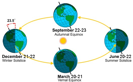
The summer solstice occurs at 10:41pm Friday, marking the official start of astronomical summer in the Northern Hemisphere. Summer weather will arrive along the East Coast just before that.
Astronomical summer begins Friday night. Image provided by the National Weather Service.
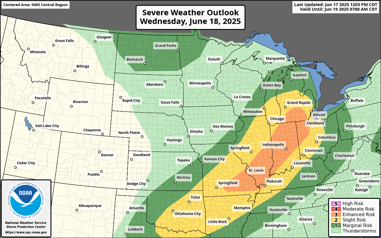
A frontal system extending from the Great Lakes into Southern Plains will slowly make its way eastward over the next few days. Ahead of the front, warm and humid air will result in an unstable atmosphere, with showers and thunderstorms developing. This front produced severe weather on Tuesday from the Front Range of the Rockies into the Central and Southern Plains, and severe thunderstorms will likely be more widespread on Wednesday from the Southern Plains into the Great Lakes. Some of the stronger storms may produce damaging winds, large hail, torrential downpours, and tornadoes, especially across parts of the Ohio Valley.
Severe weather is expected across a large swath of real estate from the Southern Plains to the Great Lakes on Wednesday. Image provided by the Storm Prediction Center.
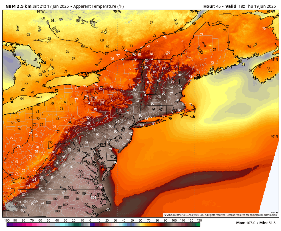
The front will continue marching eastward, heading toward the East Coast on Thursday. Ahead of the front, hot and humid weather is expected, especially along the heavily-populated I-95 corridor. For parts of the Northeast, especially from the New York City area into Southern New England, this could be the first time the mercury reaches 90 since August 28, 2024. For areas farther south, from Philadelphia into North Carolina, temperatures already reached or exceeded 90 at least once this year but could get into the middle 90s on Thursday. Accompanying the heat will be humid conditions, with dewpoints getting into the 70s for much of the region. This will result in heat indices in the middle to upper 90s for many areas, possibly over 100 from Washington southward to North Carolina.
The heat index will get well into 90s and lower 100s for much of the East Coast Thursday afternoon. Image provided by WeatherBell.
Luckily, the heat and humidity will be short-lived. The aforementioned cold front will move into the region during the afternoon and evening, producing more showers and thunderstorms, some of which could be strong to severe. The timing of the front will help determine where the strongest storms develop, but the main threats with any storms that do form are damaging winds, heavy downpours, and hail, with a few tornadoes possible.
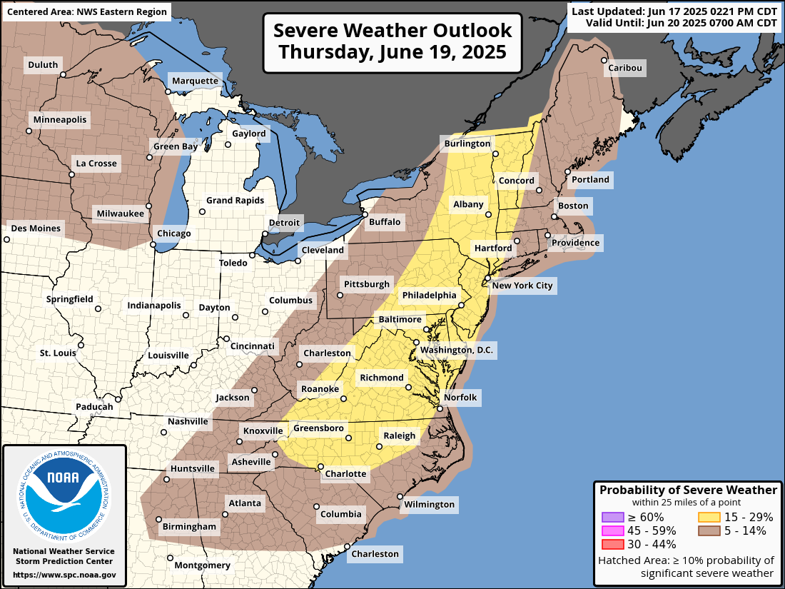
Severe weather is possible on Thursday from parts of New England to the Carolinas. Image provided by the Storm Prediction Center
Drier weather settles into the East behind the front for Friday and Saturday, though temperatures will remain near to above normal. There’s a good chance that much of the Northeast will see its streak of 13 consecutive Saturdays with rainfall finally come to an end, but that is not guaranteed yet. Some models are showing the potential for a cluster of thunderstorms to develop in the Northern Plains Friday night, then race across the Northern Great Lakes and into parts of Northern New York and New England by Saturday night. Beyond that forecast models are showing the potential for a ridge of high pressure to settle into the East Coast for the first half of next week, resulting in an extended period of hot and humid weather.
A ridge of high pressure could bring another shot of heat and humidity to the East Coast early next week. Image provided by Pivotal Weather.