As we hit the climatological peak of hurricane season, we still have several storms that are threats to land in both the Atlantic and Pacific Ocean.
The storm that is rightfully gaining the most attention is Hurricane Florence. As of midday Tuesday, Florence was centered about 390 miles south of Bermuda, moving toward the west-northwest at 16 mph. Florence reached Category 4 strength Monday evening, before undergoing and eyewall replacement cycle. What that means is that the intense thunderstorms surrounding the eye of the storm essentially weaken, but a new ring of storms forms farther away from the center. These eventually contract to form a new eyewall. While this will weaken a storm a bit, it also expands the radius of the wind field. Now that Florence has undergone this process (which will likely happen again at some point in the next day or two), its maximum sustained winds have decreased to around 130 mph, making it a Category 3 hurricane. A Hurricane Watch and Storm Surge Watch have been issued for most of the coastline of North Carolina and South Carolina.
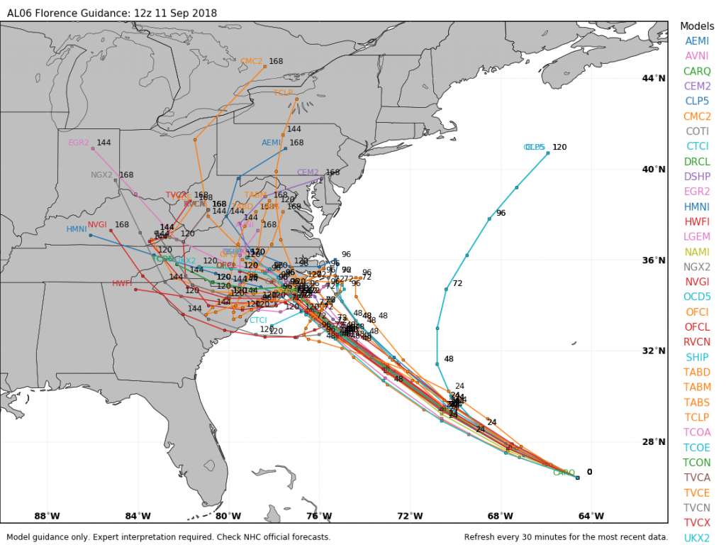
Florence is expected to continue in a general west-northwest direction for the next day or two, with more strengthening expected. It should regain Category 4 status later today, and there is a chance it could reach Category 5, depending on when the next eyewall replacement cycle takes place. By Thursday, high pressure will build in north of Florence, which will start to slow the system down as it approaches the North Carolina coastline.
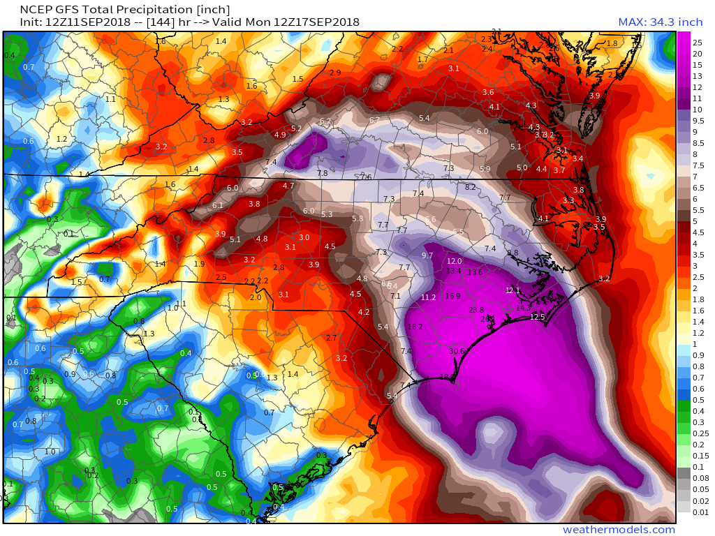
Most of the forecast models show the system slowing to a crawl or even stalling out by Friday. The big question is, does it stall out before landfall or after landfall? No matter where it stalls, many of the effects will be the same, it will just determine what happens down the road. The strongest winds will be confined to areas closest to the coastline. Once the storm stalls out, especially if it is overland, it will start to weaken, with winds becoming less of a problem. Storm surge will also be a major problem, especially across the Outer Banks and Pamlico and Albemarle Sounds. By far, rainfall and resultant flooding is the largest threat. Tropical systems already produce copious rainfall, but when they stall out, the amounts become that much higher – just look at what Hurricane Harvey did to Texas last year. In this case, with the storm expected to sit near or over the Carolinas for a few days, we could be looking at rainfall totals of 15-30 inches or more, which could lead to some of the worst flooding the region has ever seen. The torrential rain will also spread into neighboring parts of Virginia as well.
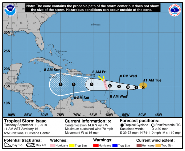
To the south, Tropical Storm Isaac is a threat to portions of the Lesser Antilles. After briefly reaching hurricane status, Isaac weakened to a tropical storm on Monday. As of midday Tuesday, Isaac remained a tropical storm with maximum sustained winds near 70 mph. It was centered about 775 miles east of the Lesser Antilles, moving towards the west at 16 mph. This track is expected to continue for the next few days, and as a result, Hurricane Watches and Tropical Storm Watches have been issued for some of the islands. Isaac is encountering some westerly shear that produced the weakening on Monday, and this will likely continue, preventing the system from strengthening much, and could result in some additional weakening. Isaac will bring gusty winds and heavy rain to many of the islands as it moves through on Thursday. It should remain south of Puerto Rico and the Virgin Islands, which are still recovering from last year’s double whammy of Irma and Maria. Some locally heavy rainfall is possible from Isaac’s outer bands as it passes to the south, but a direct hit is not expected. Beyond that, Isaac may weaken further as it continues across the Caribbean Sea.
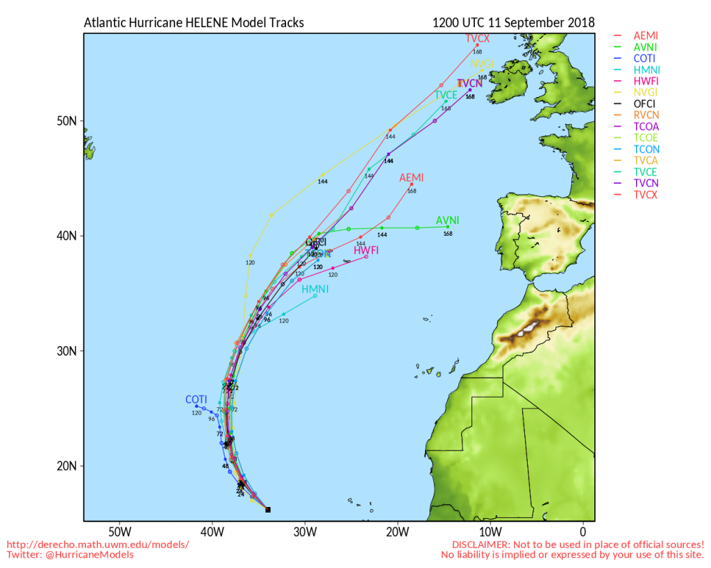
To the east, Hurricane Helene is starting to weaken over cooler waters in the Eastern Atlantic. As of midday Tuesday, Helene was centered about 1550 miles south-southwest of the Azores, moving toward the northwest at 12 mph. Helene’s maximum sustained winds were near 110 mph, but gradual weakening is expected over the next few days as the storm heads more toward the north. As we get toward the weekend, Helene should weaken to a tropical storm and may start to lose is tropical characteristics as it approaches the Azores. Gusty winds and heavy rain would be the main threats to the islands. Beyond that, it could impact parts of the British Isles as an extratropical system early next week.
Another disturbance is moving across the northwestern Caribbean and into the Yucatan Peninsula this afternoon. This system remains disorganized for now, but as it moves into the Gulf of Mexico over the next day or two, conditions could become favorable for some development. Whether it develops or not, it will bring heavy rainfall to parts of the Yucatan today and the Gulf Coast, especially Texas, over the next several days.
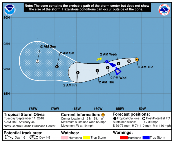
In the Eastern Pacific Tropical Depression Paul is nearly 1000 miles southwest of Mexico, and expected to dissipate over open water in the next 24-36 hours. To the west, Tropical Storm Olivia is bearing down on the Hawaiian Islands. As of midday Tuesday, Olivia was centered about 440 miles east of Honolulu, moving toward the west at 10 mph. Maximum sustained winds were near 65 mph, and slow by steady weakening is expected over the next few days. Tropical Storm Warnings are in effect for most of Hawaii, except Kauai where a Tropical Storm Watch is in effect. Olivia is expected to cross the Hawaiian islands on Wednesday. Unlike Hurricane Lane a few weeks ago which produced heavy rain across the Big Island, but stayed offshore, Olivia will likely bring heavy rain and gusty winds to much of the island chain. In some of the mountain areas, especially on the Big Island, rainfall totals of 10-20 inches and locally heavy may result in flooding in some areas once again.
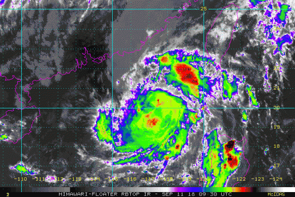
In the Western Pacific, Tropical Storm Barijat is expected to move across the South China Sea over the next few days while remaining weak. As of midday Tuesday, Barijat was centered about 215 miles southeast of Hong Kong with maximum sustained winds near 40 mph, moving towards the west at 12 mph. It should continue on a general westward track for the next day or soo with some strengthening possible, before crossing China’s Leizhou Peninsula late Wednesday. After that, it is expected to weaken before making a final landfall as a weak tropical storm or a tropical depression in northern Vietnam on Thursday or Friday. Heavy rain is the main threat with this system.
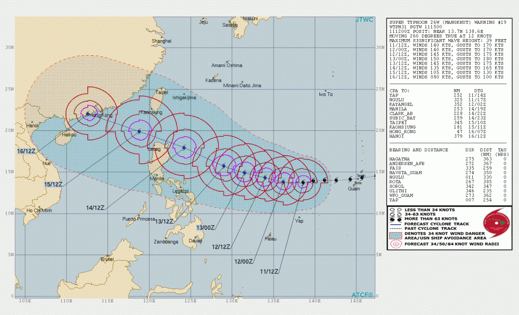
The bigger story in the Western Pacific is Super Typhoon Mangkhut. At midday Tuesday, Mangkhut, located roughly halfway between the Northern Mariana Islands and northern Philippines, had maximum sustained winds near 160 mph. It is moving westward at 14 mph, but a turn more toward the west-northwest is expected over the next day or two. Mangkhut has likely not peaked in intensity yet, and could strengthen a bit more over the next 24-36 hours. The current forecast calls for Mangkhut to pass just north of the Philippines later this week, likely close enough to bring heavy rain and strong winds to Luzon. A deviation slightly to the south of the expected track could result in landfall, and significant impacts to northern Luzon. Beyond that, a track into the South China Sea and some slow weakening is expected. The storm will become an increasing threat to southern China, including Hong Kong, by this weekend.