With the formation of Tropical Storm Vicky this morning, we now have a record-tying five storms in the Atlantic, and there may be another one coming soon.
The most immediate threat to the US is Hurricane Sally. Sally strengthening into a hurricane this afternoon, and should continue to slowly strengthen in the Gulf of Mexico for the next 24 hours. As of early Monday afternoon, Sally was centered about 160 miles southeast of Biloxi, Mississippi, moving toward the west-northwest at 6 mph. Maximum sustained winds have increased to near 90 mph.
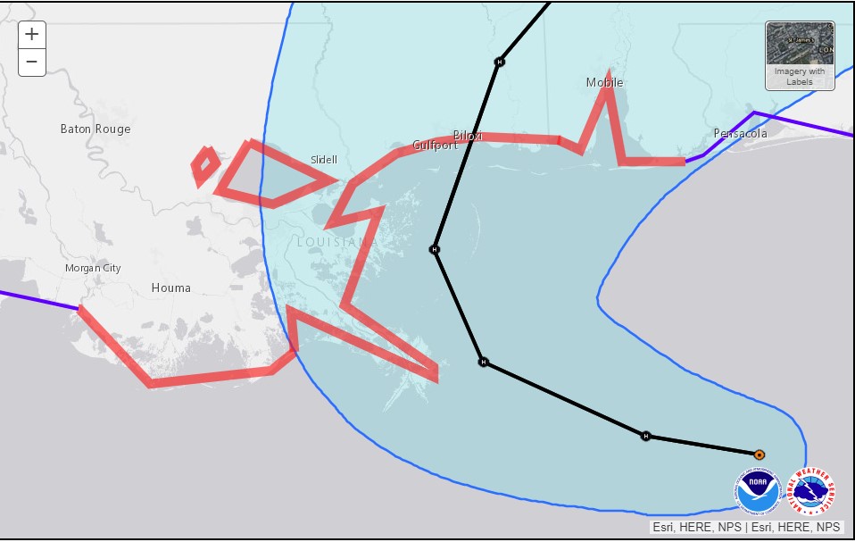
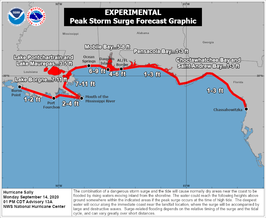
Sally is expected to track across the northern Gulf of Mexico while strengthening later tonight and Tuesday. Current forecasts call a turn to the north on Tuesday, with landfall in either southeastern Louisiana or southern Mississippi on Tuesday. Hurricane and Storm Surge Warnings are in effect for much of the region. The location of landfall will have a significant impact on what conditions occur in some locations, namely storm surge. The highest storm surge is usually found near and to the right of where the center makes landfall. A landfall in southeastern Louisiana brings that storm surge to parts of the Louisiana coast and into Mississippi and Alabama. A track a bit farther east spares Louisiana from significant surge, but increases the threat to Mississippi, Alabama, and parts of the Florida Panhandle.
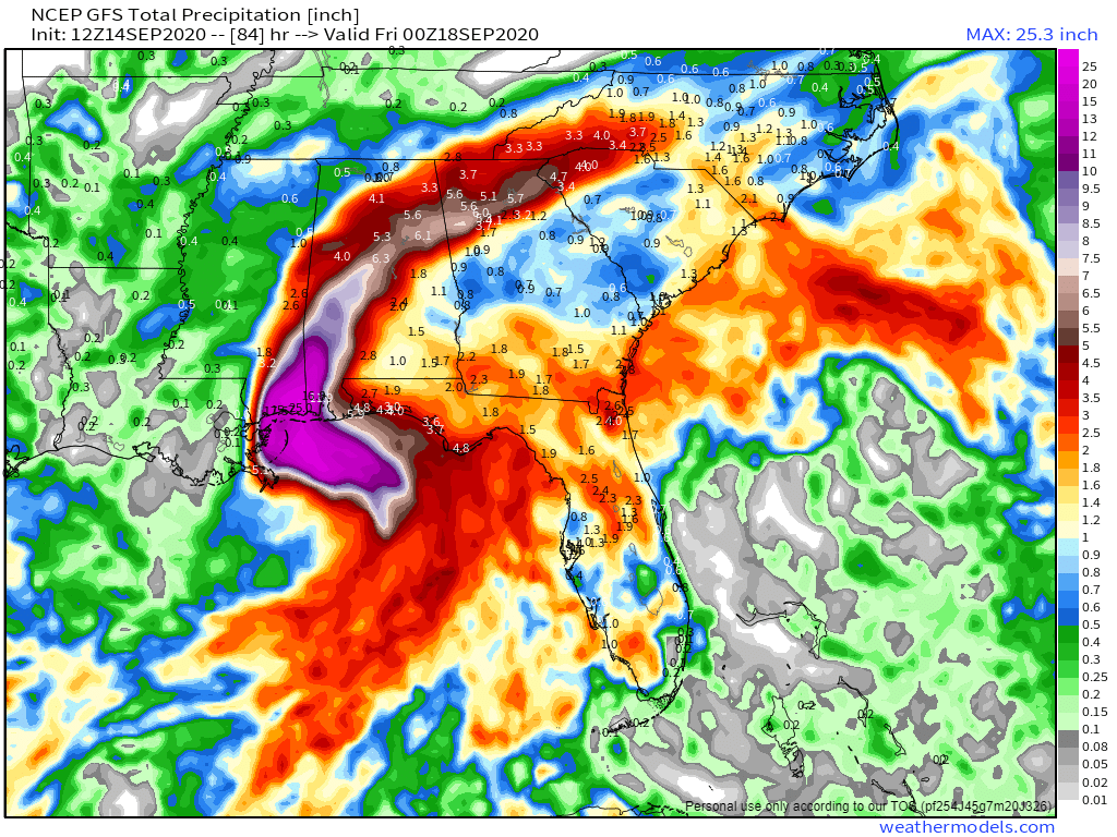
While storm surge and strong winds are significant threats, rainfall will be the most significant issue residents of the Gulf Coast need to prepare for. Sally will be a slow-mover, and could even stall out near or just after landfall. We’ve seen plenty of slow-moving tropical systems dump torrential rainfall on places in recent years, and this system will likely do the same. Rainfall totals of 15-25 inches and possibly heavier will create widespread significant flooding. The heavy rain will also spread well inland, with flooding possible into parts of the Tennessee Valley later this week.
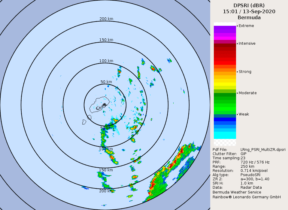
While Hurricane Sally is a threat to land, Hurricane Paulette impacted land earlier this morning, when it moved directly across the island of Bermuda. Paulette was centered about 115 miles north of Bermuda early this afternoon, moving toward the north-northeast at 13 mph. It has maximum sustained winds near 105 mph, and some additional strengthening is likely over the day or so as it turns more toward the northeast. Paulette is expected to head out into the open Atlantic over the next several days, presenting no additional threat to land.
In the central Atlantic, Tropical Depression Rene remains weak late this morning. It is centered about 1100 miles northeast of the Lesser Antilles, and maximum sustained winds have decreased to near 30 mph. Rene is expected to dissipate over open water in the next day or two.
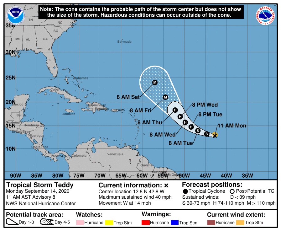
Heading further eastward, we have Tropical Storm Teddy. As of late this morning, Teddy was centered about halfway between the Lesser Antilles and the Cabo Verde Islands. Maximum sustained winds were at 40 mph, and additional strengthening is likely. Teddy could become a hurricane by late Tuesday or Wednesday, and could strengthen into a rather potent storm by later this week. A turn toward the northwest should keep Teddy over open water, though residents of Bermuda should keep an eye on this storm, as it could present a threat to the island by late this weekend or early next week.
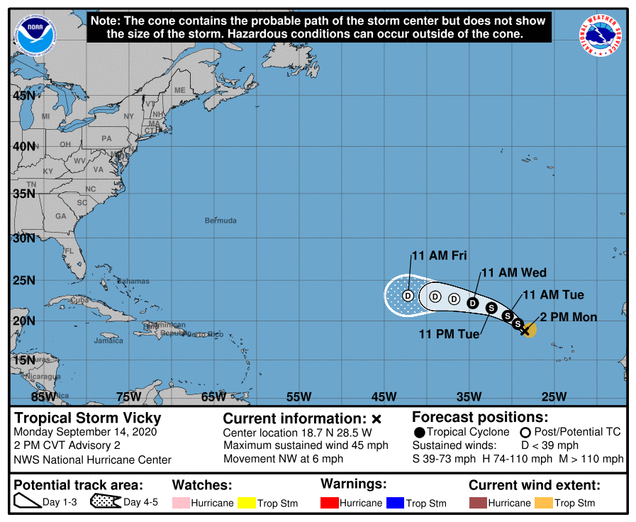
Even farther to the east, Tropical Storm Vicky developed this morning. As of late morning, Vicky was centered about 350 miles west-northwest of the Cabo Verde Islands, moving toward the northwest at 6 mph. Maximum sustained winds were near 45 mph. Vicky is expected to turn more toward the west over the next day or two while slowly weakening. It will likely dissipate over open water later this week.
With the formation of Vicky, we now have five named storms in the Atlantic. This ties the record for the most named storms at once, originally set between September 11-14, 1971. During September 11-12, 1971, there was also a short-lived tropical depression in the Atlantic, so we had 6 active tropical cyclones, a record that still has not been broken.
For the 2nd time on record, the Atlantic has 5+ tropical cyclones (tropical depression (TD) or stronger) simultaneously: #Hurricane #Paulette, TD #Rene, Tropical Storm #Sally, Tropical Storm #Teddy and TD21. Other time was from September 11-14, 1971. pic.twitter.com/9ET1OoxE6f
— Philip Klotzbach (@philklotzbach) September 14, 2020
As if five storms wasn’t enough. Another tropical wave moved off the coast of West Africa today. Conditions may be favorable for some development over the next few days as it heads westward into the Atlantic.