Hurricane Laura is now a Category 3 hurricane with its sights set on the Gulf Coast.
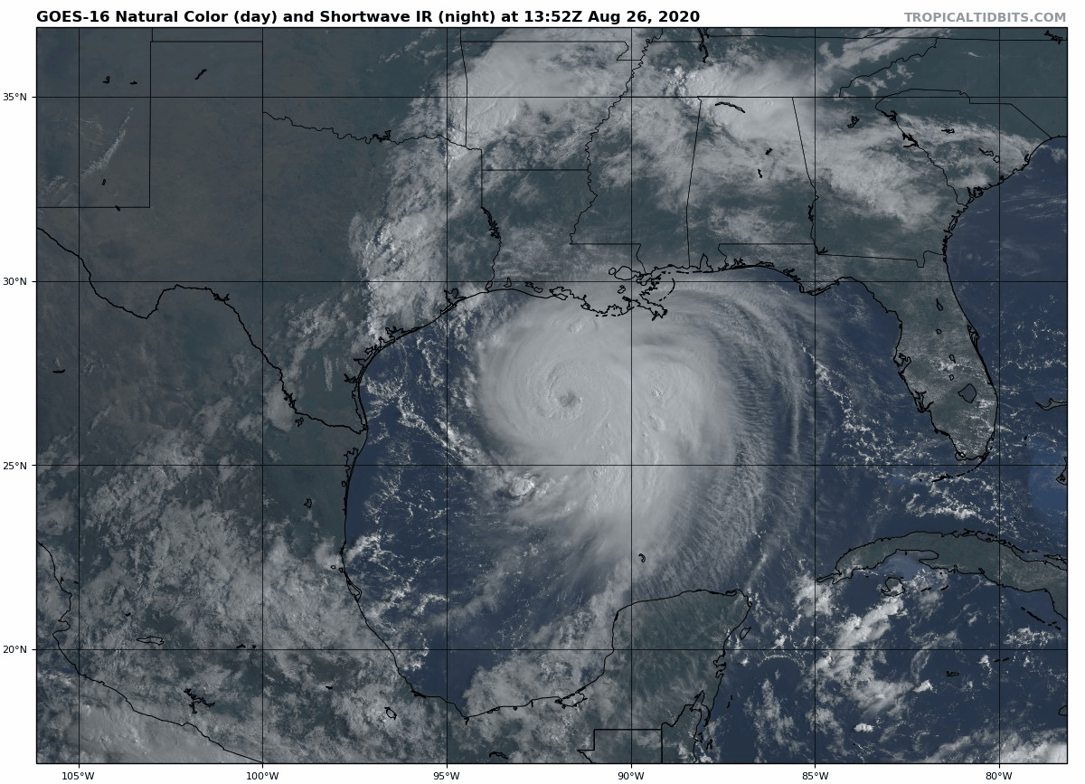
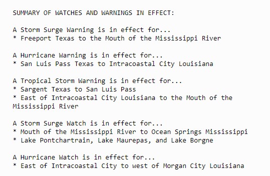
As of 11am EDT, Hurricane Laura was centered about 225 miles south-southeast of Lake Charles, Louisiana, moving toward the northwest at 16 mph. Maximum sustained winds have increased to near 125 mph, making Laura a Category 3 Hurricane. A buoy in the central Gulf of Mexico reported sustained winds of 76 mph and a gust to 107mph as the center of Laura passed nearby this morning. Hurricane and Storm Surge Warnings are in effect for portions of the Texas and Louisiana coastline, with Tropical Storm Warnings, Hurricane Watches, and Storm Surge Watches for areas adjacent to the warning areas.
The forecast for Laura is rather simple at this point. It will continue heading northwest towards a trough of low pressure moving across the nation’s mid-section. Landfall is expected tonight very close to the Texas/Louisiana border. The only question is, how strong will Laura get? Many forecast models bring Laura up to Category 4 intensity before landfall, which would mean sustained winds of 131-155 mph. However, intensity forecasts are notoriously poor. One thing that could limit intensity would be an eyewall replacement cycle. In stronger hurricanes, you’ll get a second eyewall that forms outside the center. That eyewall will eventually start to contract towards the eye, replacing the current eyewall. When this occurs, storms tend to weaken a bit. These are very hard to predict in advance.
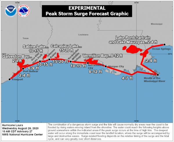
Laura presents many threats to the Gulf Coast. A storm surge of up to 15-20 feet will inundate coastal areas near and just to the east of where the center makes landfall. This will result in flooding across many of the bayous of southern Louisiana. Strong winds will obviously be a major hazard as well, mainly east of the center. The strong winds will likely penetrate well inland, as the storm will be powerful, though it should start to weaken fairly rapidly once inland.
By far, the biggest threat, as it is with most tropical systems, is heavy rain and the freshwater flooding it will produce. Rainfall totals of 10-15 inches and locally heavier are likely across extreme southeast Texas and western Louisiana. Since Laura is moving fairly quickly and not expected to stall out, we shouldn’t see a repeat of the 30-60 inches that Harvey produced in the same area 3 years ago this week.
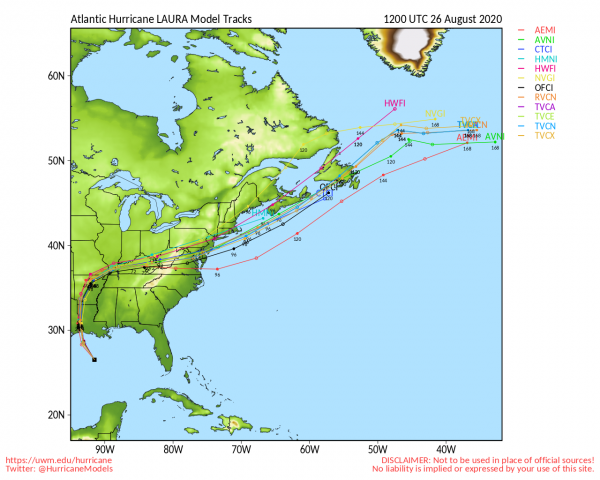
Farther inland, rainfall totals of 3-6 inches are expected up into Arkansas. As the storm gets caught up in the jet stream and becomes extratropical, it will bring heavy rain to parts of the Ohio Valley and Mid-Atlantic states Friday into Saturday. Once it moves off the coast, it may strengthen a little, and could enhance some of the rain expected across New England and Atlantic Canada this weekend associated with a cold front.
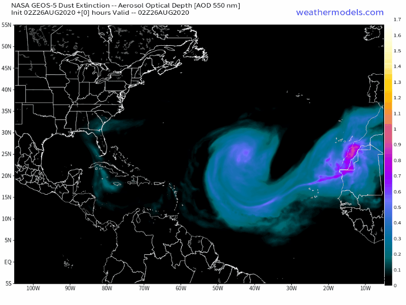
Once Laura moves inland, the Atlantic should remain quiet for the next week or so. Plumes of Saharan Dust continue to move off the west coast of Africa and traverse the Atlantic and Caribbean. The very dry air associated with these plumes inhibits thunderstorm development, which means they also prevent tropical systems from developing.
Laura isn’t the only active storm in the tropics right now. This morning two separate tropical depressions have developed in the Eastern Pacific, off the southwestern coast of Mexico. Both are expected to become tropical storms in the next 24-36 hours, but remain relatively weak. Tropical Depression 13-E may bring some heavy rain and gusty winds to southern portions of Baja California late this week, but Tropical Depression 14-E should not impact any land areas.
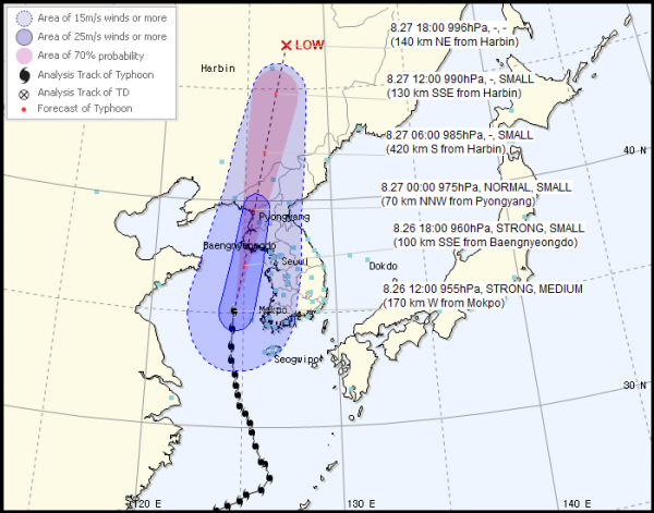
In the Western Pacific, Typhoon Bavi has maximum sustained winds near 110 mph as it moves into the Yellow Sea. The current forecast calls for the storm to make landfall in western North Korea this evening, then rapidly weaken as it moves inland into extreme northeastern China. As with Laura, strong winds and storm surge will have significant impacts on the region, but rainfall totals of 4-8 inches and locally heavier will result in flooding in many areas.