Record rainfall and catastrophic flooding continue across Texas today, especially in the Houston metropolitan area, and things won’t improve much any time soon.
As of midday Monday, Tropical Storm Harvey was centered close to the Texas coastline near Port O’Connor, drifting southeastward at 5 mph. This motion will bring the center of Harvey back out over the Gulf of Mexico this afternoon. A lot of dry air has wrapped around the south side of Harvey’s circulation, with the bulk of the heavy rain bands north and east of the center. Despite moving back over the Gulf, only some slight intensification is expected over the next day or two. Harvey currently has maximum sustained winds near 40 mph. A Tropical Storm Warning is in effect for the Gulf Coast from High Island, Texas to Cameron, Louisiana. A Tropical Storm Watch is in effect east of Cameron, to Intracoastal City.
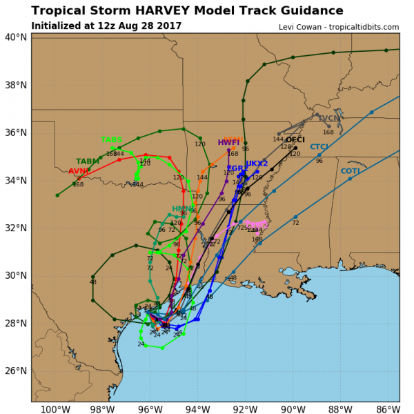
An upper-level trough of low pressure will drop into the Ohio Valley over the next day or two, and this will draw Harvey northward, finally pulling it out of the region. A second landfall, likely as a tropical storm, is expected towards the middle of the week somewhere along the Upper Texas or western Louisiana coastline.
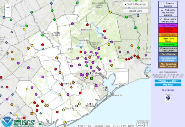
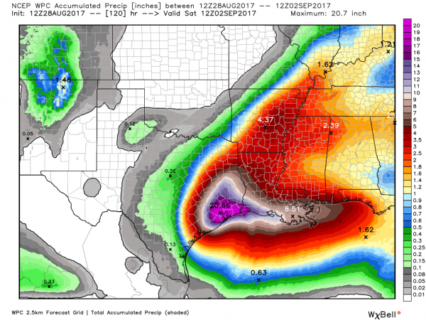
Rainfall totals of 15 to 40 inches have already been reported across the region, especially across the Houston metropolitan area. The highest reported total as of midday Monday was 39.72 inches in Dayton, about 35 miles northeast of Houston. Bands of heavy rain will continue to rotate in from the Gulf across southeastern Texas and adjacent Louisiana over the next few days. An additional 10 to 20 inches of rain may fall across the region over the next few days, which will only worsen conditions across the area.
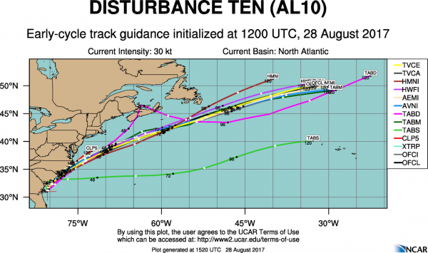
While all the attention has been focused on Texas, another disturbance produced heavy rain across portions of Florida over the weekend. The hardest hit area was southwestern Florida, where 6 to 12 inches of rain was reported over the weekend. A few locations in Manatee County, near Sarasota, had isolated totals of up to 22 inches. That disturbance moved into the Atlantic again on Sunday, and was designated by the National Hurricane Center as Potential Tropical Cyclone 10. The system remains poorly organized as of midday Monday, without a well-defined low-level center of circulation. However, conditions are favorable for a subtropical or hybrid storm to form over the next day or so. If it does become a tropical or subtropical storm, it will be given the name Irma.
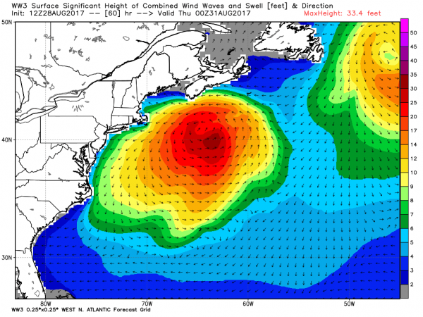
The system will bring heavy rain and gusty winds to coastal portions of the Carolinas through Tuesday. A Tropical Storm Warning is in effect from Surf City, North Carolina northward to Duck, including the Pamlico and Albemarle Sounds. South of Surf City, a Tropical Storm Watch is in effect to the South Santee River, South Carolina. The system should head in a general northeasterly direction for the next day or two, with the possibility that the center moves over inland over eastern North Carolina briefly. Once it emerges from the Outer Banks of North Carolina, it will start to head more in an east-northeast direction and accelerate. It will also likely lose any remaining tropical characteristics by then, becoming an extratropical system. At this point, it will likely strengthen into a fairly strong gale, which could brush coastal New England or Atlantic Canada with some gusty winds and possibly some rainfall along the coast towards midweek. This will also increase the threat of rip currents at beaches, as large waves will impact the coastline.
Another tropical wave has also emerged from the coast of Africa. It will bring heavy rain and gusty winds to the Cape Verde Islands over the next day or two and then continue westward across the Atlantic. Conditions look favorable for development at this time, and another tropical depression could form later this week.