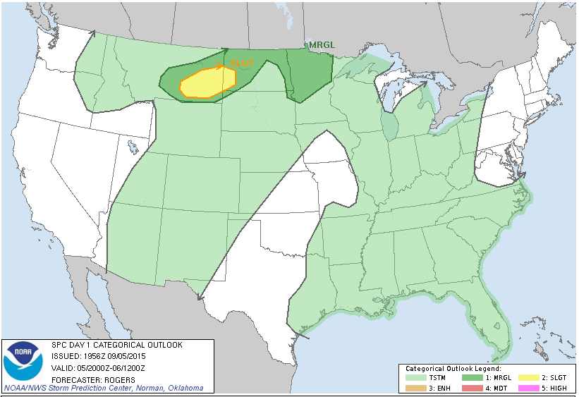
Showers and a few isolated thunderstorms started the morning in portions of the Northern Plains. As the day goes on, those showers and storms will move toward the east as a low pressure system and its warm front move northeast. One question will be if the cloud cover can subside and allow for enough surface heating. If the clouds do break, this will allow for stronger afternoon showers and thunderstorms to pop over eastern portions of North Dakota and South Dakota. Otherwise, the start of those pop-up showers and thunderstorms may be delayed and may actually occur in Minnesota. Any pop-up storms will be moving to the north or northeast through the evening hours and into Minnesota, Canada and possibly Northern Wisconsin overnight. With all this in mind, it’s entirely possible that most unstable CAPE values top out over 1000 J/kg and shear values reach over 30 to 40 knots and so the main threats for these storms will be strong winds, hail, heavy rain and a tornado or two. Behind the low pressure system for Sunday, cold air will be pouring in on strong winds from the north, cutting down the humidity.
Meanwhile, the tropics continue to be active, especially in the Pacific Ocean with Hurricane Jimena continuing to move on a northwest track. Jimena is forecast to slowly weaken to a tropical storm tonight. By midweek, a trough is expected to dive south from the north-central Pacific. Because of this, some models, as well as the National Hurricane Center (NHC), indicate the storm may take a track toward the Hawaiian islands of Kauai and Oahu. This is not entirely set in stone with a few models also taking the storm straight west, to the north of Kauai. Also, the Western Pacific has a strong typhoon (Kilo) which has been a typhoon since it crossed the dateline as a hurricane and may continue churning in the Pacific for a while longer. A strong disturbance in the Eastern Pacific located a few hundred miles west of the southern tip of the Baja California Peninsula may develop into a tropical system later today or Sunday. Post-tropical storm Kevin continues to weaken as it takes a track to the northwest, just west of the Baja California Peninsula. El Nino has had a strong effect on this year’s tropical activity with the strong positively anomalous warm sea surface temperatures supporting and enhancing the Pacific hurricanes and typhoons.
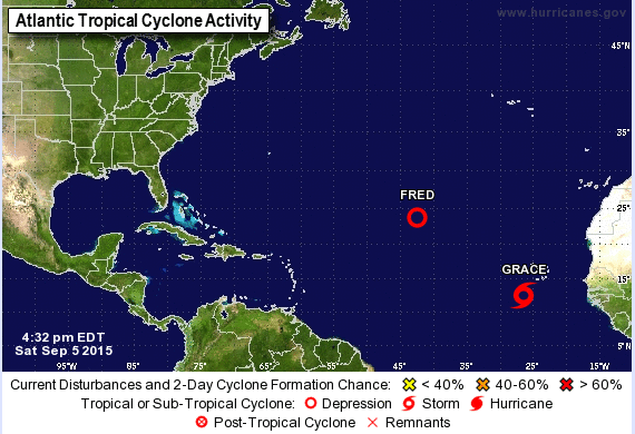
In the Atlantic, Tropical Depression Fred continues to spin over the open ocean and will move toward the west-northwest. It is forecast to track toward the north and then to the northeast during the next two days. Tropical Depression Fred has been running into strong shear, which should continue to slowly downgrade Fred, as indicated by NHC. In addition, a new tropical storm (Grace) has formed in the Atlantic and is located 285 Miles southwest of the Cape Verde Islands. Grace will take a trek toward the west maintaining tropical storm strength the whole time. However, it may run into shear over the next 2 to 3 days, which could cause the storm to weaken or dissipate east of the Lesser Antilles. Previous storms Danny and Erica ran into problems with shear and dissipated because of it already this year. Shear has been a problem this year for storms in the Atlantic even as warm water has helped to awaken the Atlantic. Even though, El Nino helps to create favorable conditions in the Pacific Ocean, it helps to create unfavorable conditions in the Atlantic Ocean in the form of shear ripping apart any tropical systems that aren’t big or strong enough to maintain themselves with in it.