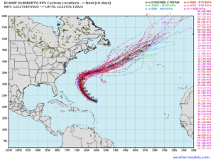
While the 2025 Atlantic Hurricane season has remained relatively quiet, things are starting to ramp up as we end September. Hurricane Humberto, now a Category 5 storm, will continue on a northwest track before turning northeast toward the beginning of the week. The storm will travel between Bermuda and the eastern United States coast, while remaining over open waters as it progresses into the Northeast Atlantic.
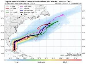
Another disturbance being monitored near Haiti and the Bahamas has been named Tropical Storm Imelda, with strengthening expected to continue through the start of the week as it becomes more organized. This system will progress north, toward the Carolinas, where areas are still recovering from the devastation brought by Helene just one year ago.
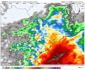
A frontal system moving off the East Coast will remain stalled, allowing rainfall to continue through the next several days. As Tropical Storm Imelda moves north, it will interact with the stalled front, then turn east and remain out at sea. Areas closer to the North and South Carolina coasts will have the highest chance of significant rainfall from these systems, with higher totals also possible locally, especially in higher terrain.
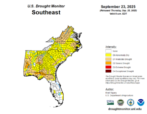
Much of this area is currently experiencing abnormally dry to moderate drought conditions, so many residents in this area are hoping for relief, but that will likely not be the case. When heavy and excessive rainfall occurs, especially in regions experiencing drought, the ground struggles to absorb the water at the rate at which it is falling. This, in turn, will cause flooding, which can be extreme and catastrophic, especially in areas still recovering from previous flooding events.