Many families across the United States will be trying to squeeze in one last summer activity this weekend, as Labor Day marks the unofficial end of the summer season. Fortunately, many areas will experience sunshine and dry weather as high pressure dominates the majority of the pattern across the country, while others may not be so lucky.
A large stalled front will bring rain to much of the Gulf Coast and Southern Plains through the weekend, with heavy rainfall expected. Flash flooding will be a concern for eastern New Mexico, central and western Texas, and the Central Plains on Saturday, while west and central Texas, as well as southern New Mexico, remain at risk for flooding through Sunday. Showers could also spread into the Tennessee Valley on Monday as the front remains stationary.
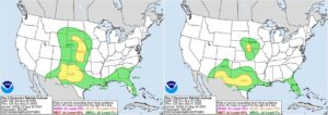
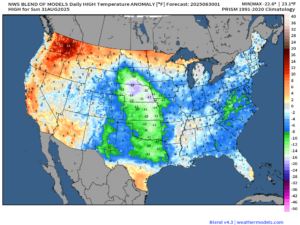
The front will also extend into the Rocky Mountains, bringing showers and thunderstorms to start the weekend. A warm front will break off and progress east on Sunday with a low pressure system moving across the northern part of the country. Areas in extreme eastern Nebraska could be at risk for flash flooding as this system begins progressing east. Temperatures will average well below normal ahead of this system and return to near normal on the backside.
A cold front in association with a low pressure system slowly moving into Atlantic Canada will extend into the Mid-Atlantic and Tennessee Valley on Saturday, allowing for some extra cloudiness across the region. This system will also send disturbances through the Northeast, bringing an increase in clouds during each afternoon, especially on Saturday. Areas in extreme northern New England may also see a stray shower or two, particularly in the afternoon as the disturbance moves through.
Areas along the West Coast will experience dry weather through the weekend, with temperatures averaging near normal to start the weekend, then shifting above normal toward the end of the weekend, with extreme heat possible, especially in interior areas.
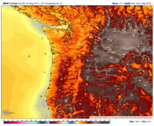
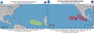
Looking at the week ahead, things are expected to remain relatively quiet. Areas across the Central U.S. will continue to see well below normal temperatures ahead of a slow moving warm front. Areas in the west, specifically in the Pacific Northwest, will continue to see above average temperatures, where hot temperatures are expected to continue through the remainder of the week. There are no active storms in either the Atlantic or the Pacific; however, some areas are being monitored for potential development as the week progresses.