A strong storm system moving out of the West will bring heavy snow to the Rockies, severe weather to the Mississippi Valley, and maybe even some lake-effect snow to parts of the Great Lakes before the week is over.
A developing low pressure area will move across the Rockies and into the Central Plains today. Over the weekend this storm brought beneficial rainfall to California, with snowfall across the higher elevations of the Cascades and Sierra Nevada. Up to an inch of rainfall fell across the San Francisco Bay area, with locally heavier amounts of 1-2 inches in Santa Clara and Santa Cruz Counties. Farther inland, 1-2 inches of rain was reported across much of the Central Valley. Strong thunderstorms were also reported across the area, with a tornado warning issued Monday evening for the suburbs of Sacramento, though no tornado was ever confirmed to have touched down. In the Sierra Nevada, as much as 6-12 inches of snow was reported as of Tuesday morning. At the National Weather Service office in Reno, Nevada, four inches was reported in one hour Monday evening.
As the system moves eastward, snow is expected across much of the Intermountain West today into Wednesday. The heaviest snow is expected across the mountains of Utah and Colorado, where 8-16 inches may accumulate. Rain will change over to snow across the western Plains as colder air filters in behind the system. Snowfall totals of 3-5 inches are expected across western portions of Nebraska and Kansas as well as eastern Colorado, including the Denver Metropolitan Area. The snow will be accompanied by northerly winds of 20-40 mph, gusting to 60 mph at times. As a result, blizzard warnings are in effect for much of this region, with high wind warnings for much of the remainder of the Central and Southern Plains.
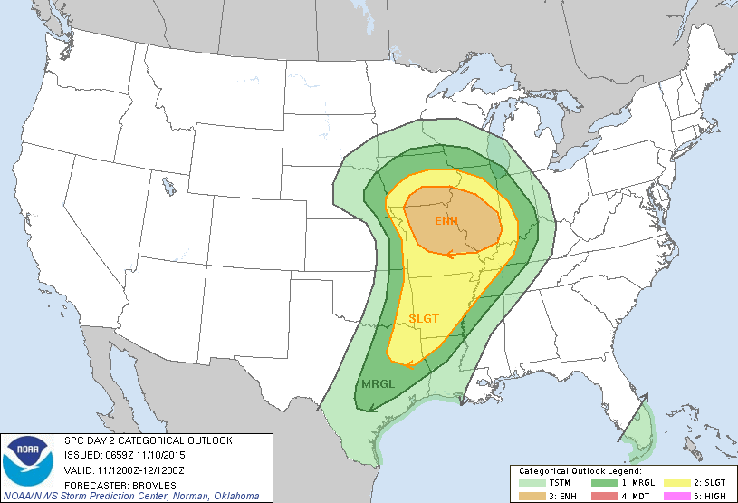
Southerly winds ahead of the storm will continue to draw warm, moist air northward from the Gulf of Mexico. With the clash of airmasses, strong to severe thunderstorms will likely develop ahead of the cold front on Wednesday from northeastern Texas into much of the Mississippi Valley. Strong winds, hail, and tornadoes are the main threats with any storms that do develop. The best chance for tornadoes looks to be across portions of Iowa, Illinois, and Missouri, where a few strong tornadoes are possible. Just to the north of this area, heavy rain is likely from eastern Nebraska and northern Iowa into southern Minnesota and much of Wisconsin. Rainfall totals of 1-2 inches are possible across this area.
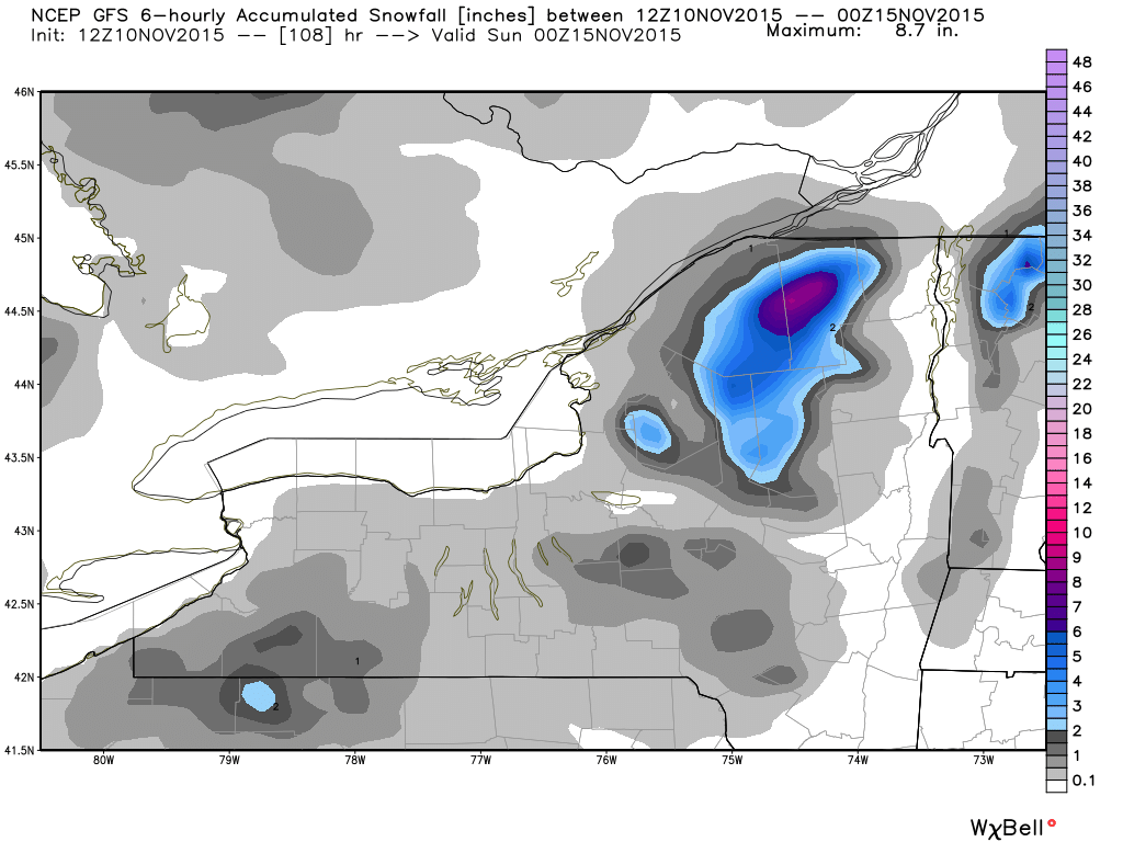
By Thursday, the storm will move into southern Canada, dragging a cold front across the East. This will produce showers across much of the Northeast and Mid-Atlantic states, with gusty westerly winds ushering in cooler air behind the front. As these westerly winds blow over the relatively warmer Great Lakes, some lake-effect rain or snow showers will likely develop on Friday and Saturday. Some snowfall accumulation is possible, mainly over the Tug Hill Plateau of northern New York and parts of the Southern Tier in western New York. A few inches of accumulation are possible, with heavier amounts in the normally favored locations.