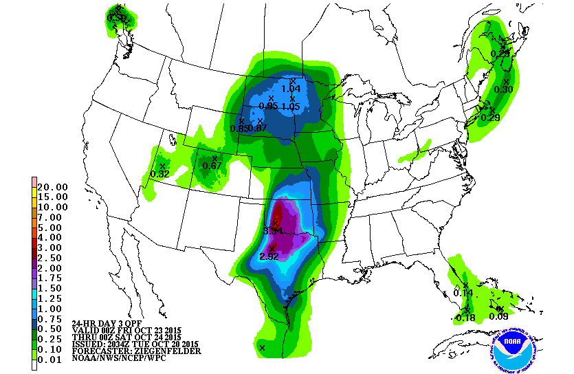
An upper level low pressure system will slowly move into the Southwest over the next few days. Between Thursday through Saturday, plenty of moisture will be streaming in from the south, resulting in 2 to 3 inches of rain falling in portions of the Great Plains. Mechanisms helping this along include the strong low level jet from the south with an intensity that is 2 to 4 standard deviations above normal at times. Favorable upper level jet dynamics, in the form of the right rear quadrant of the upper level jet, will be above the region, allowing for strong large scale lift. Moisture in the atmosphere, in the form of precipitable water, will also be 2 to 4 standard deviations above normal. The one important part of the movement of this system is the fact that the low pressure system gets picked up by a trough to the northwest and directed north, meaning that the main forcing gets directed north while the bulk of the moisture stays south. At the same time, however, the precipitation is directed into the same area in northeastern Texas Thursday night to Sunday morning as a cold front runs into a surface trough. All in all, while severe storms are possible with this setup, flooding seems the most problematic outcome with a continuous flow of moisture paired with dry hard-packed soil that will suck up little rainfall in portions of the Southern Great Plains. The rain should shutoff early Sunday as a ridge of high pressure enters. The ridge of high pressure lasts until Tuesday, when another cold front comes in.
Meanwhile, in the Tropics, the Atlantic remains quiet. However, in the Eastern Pacific, Tropical Depression Twenty-E is centered about 235 miles southeast of Puerto Escondido, Mexico as of Tuesday evening. This low pressure system will be directed to the west-southwest by a mid-level ridge just to its north, over the Gulf of Mexico. The ridge is forecast to move eastward so the low pressure system is then steered to the north between an approaching front to the west and the high pressure ridge to its east. Guidance also seems to be in agreement that a landfall in western Mexico should occur around Saturday as a hurricane. An increasing intensity has been indicated by the previous text in this paragraph and this fits with the large scale environment being conducive for development. The main contributors are very warm sea surface temperatures and light shear adjacent to the storm. Even still, two areas with negative impacts on the storm are possible with dry air entrainment into the storm from strong winds through the Isthmus of Tehuantepec and an uncertain inner core strength. If the inner core does get strong enough, dry air entrainment will become less of a problem. It is thought that the positive factors will outweigh the negative factors so intensification is forecast with the storm becoming a Tropical Storm between now and early Wednesday. In the Central Pacific, Hurricane Olaf is located 1060 miles east-southeast of Hilo, Hawaii and 1275 miles east-southeast of Honolulu Hawaii. Hurricane Olaf does have 15 nautical-mile wide eye and a concentric ring of convection. A recurving track is forecast for Olaf as it moves around a ridge of high pressure to its north. Then a disturbance picks up Olaf and brings it northeast. This track keeps the bulk of the hurricane’s main impacts away from the Islands, but a strong swell is still possible this weekend. Shear is expected to remain weak until later Wednesday and the system does move over warm sea surface temperatures so strengthening is possible in the near term. Next, shear is expected to increase water temperatures are expected to decrease so weakening is possible starting Friday.