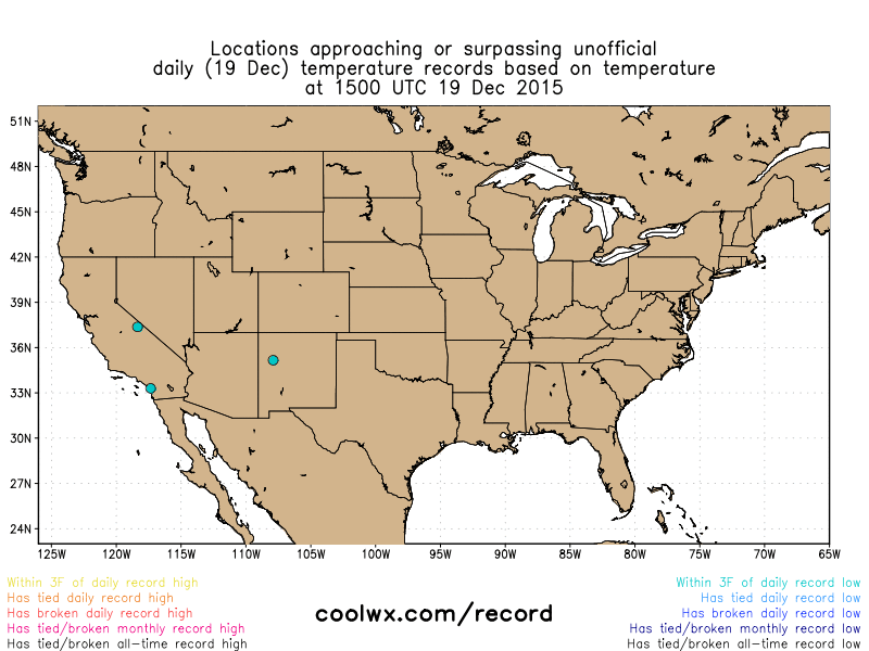
Much of the talk over the past few days has been about the record breaking temperatures around Christmas time. And rightly so, because many temperatures reached the mid to upper 60s in the East and Northeastern US breaking old records by as much as 5 to 10 degrees while many hoped for a White Christmas. This all happened at the same time as intense storms ripped through the Midwest and Southern US, leaving damage behind. However, a quick cold shot will bring the Northeast quickly right back to reality come Monday as a piece of energy dives into the Northeast that can trace its origins to Northwestern Canada and will bring with it, very cold temperatures. Some of the coldest temperatures that the Northeast has had all winter are expected. Monday, as high pressure sits in Southeastern Canada, cold air will be able to drain south from Canada on northerly winds. Temperatures may not get out of the 30s in many spots on Monday and dew point temperatures (a measure of moisture) will be below freezing, indicating the strength of the cold and dry air.
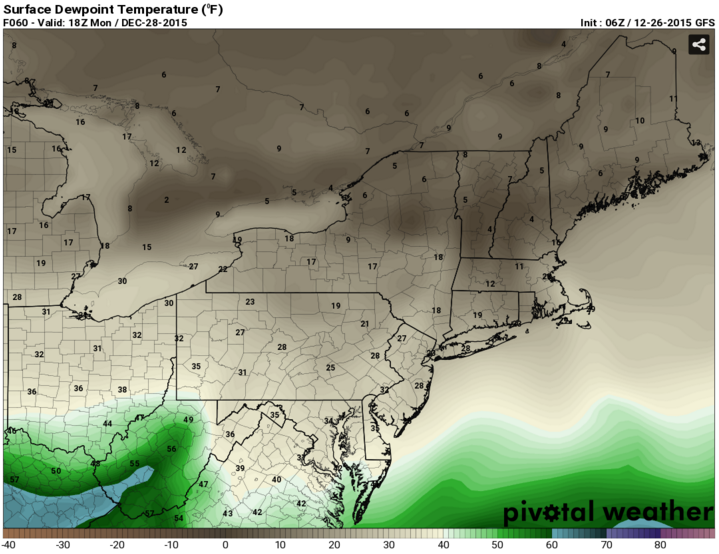
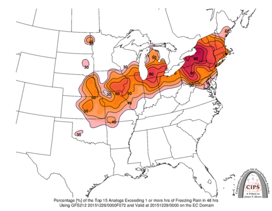
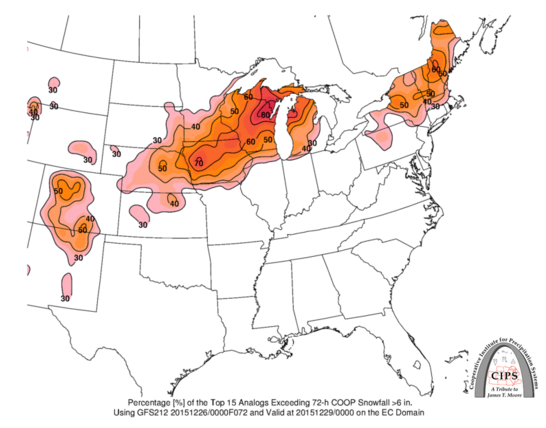
The strength of this cold and dry air is very important because right after this cold shot passes through, moisture will be coming up from the south in a very common setup, for what is called overrunning. What happens is that warm, less dense, moisture from the south rides over cooler, denser air at the surface and results in precipitation. It is common for this setup to have precipitation hold off as the moisture aloft fights with the drier air at the surface to be able to reach the surface. As the moist air evaporates before it reaches the ground, it actually acts to cool the air, thus keeping temperatures near or just above the freezing mark during the day, much like sweating keeps us cool during the summertime. With surface temperatures remaining around freezing, the initial precipitation that does fall will have an opportunity to fall as wintry precipitation. Forecast atmospheric profiles, known as soundings, show that temperatures at the surface and aloft will remain below freezing as the warm moist air enters the region so the precipitation type should start as snow. However, as the warm, moist air continues to come in, especially since it will be helped along with any additional daytime warmth, midlevel temperatures will be able to warm and the atmospheric profile will begin to look like one that will produce sleet and freezing rain before eventually changing to rain by days end. The strength of the winds aloft behind the warm front (signaling the entrance of the warm, moist air) is important because this will tell how quickly the warm air mass can come in from the south and change everything to sleet, freezing rain and rain and it will tell how far inland the warm air is able to come from the ocean as the winds come in from the southeast in the form of a coastal front. If this coastal front is able to set up, snow fall amounts could be increased on the western cold side of the coastal front. In addition snowfall amounts may be bumped up just to the north of the warm front because it will have decent mid to lower level energy along it, but at the same time, most of the energy appears to be outside of the zone for best snowfall growth so total snowfall won’t be as high as it could be. The most likely time frame for the snow to occur would be the morning into the midday hours ahead of a possible change over to sleet and freezing rain, which would occur from the midday hours on and a changeover to all rain could occur in the afternoon to evening hours. Of course, if any snow accumulation does occur, rain on top of that would spell trouble for driving as slush may form on the street, further exacerbated by any sleet and freezing rain that could fall on Tuesday. Of course, there’s always the wrinkle of if a coastal low pressure system does form because this would also act to keep cooler air around longer extending the longevity that the wintry precipitation resides in New England on Tuesday instead of rainfall. The area of low pressure should then push northeast and be out of the area overnight Tuesday night.