Strong to severe thunderstorms are expected across the Great Lakes today, with the threat shifting into portions of the Northeast and Ohio Valley on Tuesday.
Low pressure will move into southern Canada today, with a warm front out ahead of it. After the front moves through, temperatures will rise well into the 80s, with dewpoints into the upper 60s and 70s. At the same time, a cold front will be sweeping southward across the Northern Plains and Upper Midwest, triggering showers and thunderstorms across the area.
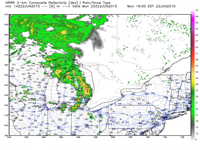
Late Sunday, this front produced severe weather across the Northern Plains, with baseball sized hail across portions of Montana and the Dakotas. There were also dozens of reports of strong winds, including a gust to 122 mph near Hayes, SD that destroyed grain bins and moved an office building. That area of storms, known as a Mesoscale Convective System or MCS, moved into the Great Lakes this morning and will continue eastward. New thunderstorms will likely develop ahead of that cold front this afternoon, and move across the same areas getting hit hard this morning. Some of these storms will contain large hail, wind gusts in excess of 80 mph, and likely a few tornadoes. The area most at risk includes the metropolitan areas of Chicago, Milwaukee, and Detroit.
On Tuesday, as the cold front moves south and east, the severe weather threat will shift into the Northeast and Ohio Valley. The initial area of thunderstorms (MCS) will move across New York and New England overnight and into Tuesday morning. Once it moves through, skies will start to clear out a bit, and showers and thunderstorms will redevelop ahead of the cold front. Some of these storms will become strong to severe, with hail, strong winds, and a few tornadoes possible once again. The area most at risk on Tuesday includes the metropolitan areas of Cincinnati, Pittsburgh, Washington, Philadelphia, and New York City.
Across New England, the severe weather threat on Tuesday will be dependent on how much sunshine develops after the initial area of thunderstorms moves through in the morning. Strong to severe storms are likely across western portions of New England, but they should start to weaken as they move eastward. Southerly winds blowing off the relatively cool Atlantic will help stabilize the atmosphere across eastern portions of New England, helping the storms lose their punch as they approach Boston and Providence.
Behind this cold front, comfortable conditions will settle into the Midwest on Tuesday and the Northeast on Wednesday, with high temperatures mainly in the 70s to lower 80s and dewpoints in the upper 40s and 50s.