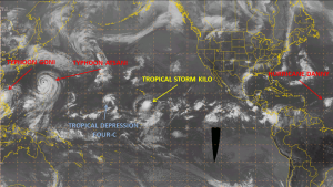
The tropics continue to heat up, and it looks like two is the magic number. There are two typhoons in the Western Pacific, two tropical storms in the Central Pacific and in the Atlantic we have Hurricane Danny and two other areas to watch.
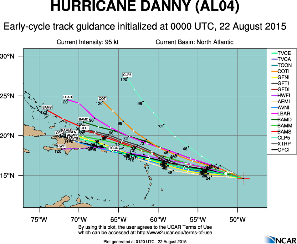
Starting in the Atlantic, Hurricane Danny underwent a burst of rapid intensification on Wednesday, with top winds now near 115 mph. This means Danny is now a major hurricane – Category 3 on the Saffir-Simpson scale. Danny remains a very small storm, with hurricane force winds only extended 15 miles from the center of the storm. Danny is moving towards the west-northwest at 10 mph, and this general track is expected to continue for the next few days. It appears as though Danny has peaked in intensity and should start to weaken over the next few days. The environment ahead of the storm is rather hostile, with dry air and strong wind shear, which will likely help Danny weaken to a tropical storm as it approaches the Northern Leeward Islands on Monday. Some of the computer models are indicating the Danny may degenerate into a tropical wave as it moves into the Eastern Caribbean Monday and Tuesday.
Elsewhere in the Atlantic, there is a weak area of low pressure south of Bermuda that is producing scattered shower and thunderstorm activity as it interacts with an upper-level low pressure system. The storm should turn more towards the north and eventually northeast over the next few days, staying over the open waters of the Atlantic. There is the possibility that it could acquire tropical or subtropical characteristics, but it shouldn’t impact any land areas.
Another tropical wave has moved off of the coast of Africa and is approaching the Cape Verde Islands. While it is disorganized at the moment, conditions appear favorable for some development over the next few days as it moves swiftly across the Atlantic Ocean.
Across the Central Pacific, the most immediate threat is Tropical Storm Kilo. Kilo has top winds near 40 mph and is located about 480 miles south-southeast of Hilo, Hawaii. Kilo is moving west-northwest at 16 mph, and should continue on this track over the next day or two while steadily strengthening. Kilo is expected to turn more towards the north and northeast over the weekend. Depending on when the turn actually occurs, Kilo could be a threat to the western Hawaiian Islands. There is still a lot of uncertainty as to how strong Kill will eventually get, but it seems likely that it will at least attain hurricane strength.
A little farther to the west, Tropical Depression Four-C strengthened into Tropical Storm Loke on Friday. Loke is located about 500 miles west of Johnston Island, and is moving toward the north at 6mph. Top winds are near 45 mph. Loke should continue on a general northerly track through the weekend before turning a bit towards the northeast early next week. Loke should remain over open waters through the weekend, but the current track brings it close to Midway Island early next week. The current forecast indicates the Loke should remain a tropical storm, but it wouldn’t be a big surprise if Loke became a Hurricane over the weekend.
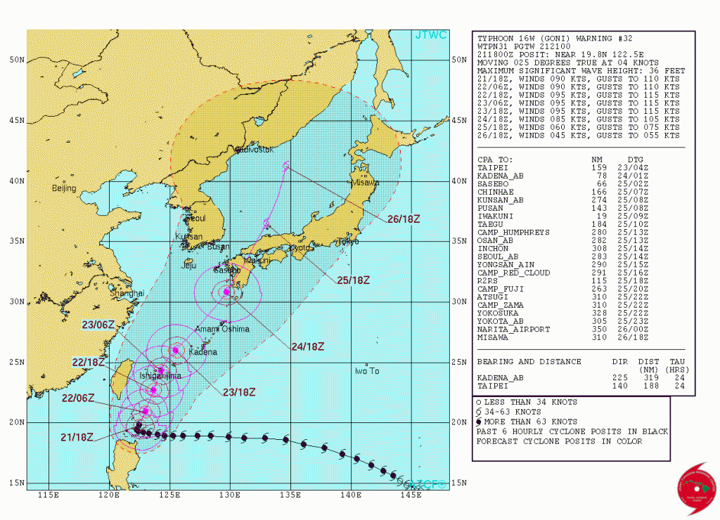
Heading across the International Dateline and into the Western Pacific Ocean, twin typhoons continue their journeys. The bigger threat is Typhoon Goni, located just north of the northern tip of the Philippines. Goni has top winds near 105 mph, and some strengthening is possible over the weekend as Goni heads northward, passing just east of Taiwan. This will bring another round of torrential rain to the island, not long after Typhoon Soudelor dropped upwards of 40 inches of rain on parts of Taiwan. Winds have already gusted as high as 72 mph in southeastern portions of the Taiwan from Goni. A slight turn toward the northeast is expected this weekend, and Goni will likely make landfall in southwestern Japan early next week as a weak typhoon. Earlier on Friday, Goni dropped up to 15 inches of rain in the northern Philippines, with wind gusts as high as 51 mph.
Meanwhile, Typhoon Atsani is located several hundred miles southeast of Japan with top winds near 105 mph. Atsani is expected to head north and then northeast over the weekend while steadily weakening. Atsani should remain over open waters for the next few days, with only a few small islands near the current path of the storm.
The Eastern Pacific has remains quiet for a few days, but another system is being monitored for development over 1000 miles southwest of the Baja California. The tropics are expected to remain activate for the next few weeks as the peak of hurricane season in the Atlantic and Eastern Pacific approach.