The Week Ahead: December 27, 2021 – January 2, 2022

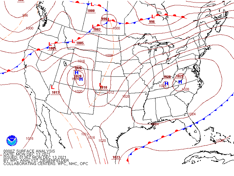
A rather active week is expected across the nation, with heavy rain and snow in the West and the Rockies, record heat and potentially severe weather in the South, and heavy snow and bitterly cold temperatures for the Northern Plains.

A frontal system extended from coast to coast separates unseasonably warm air to the south from colder air to the north. Image provided by NOAA.


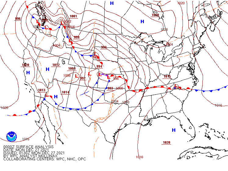
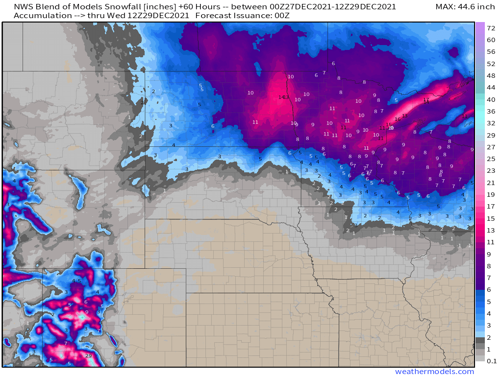
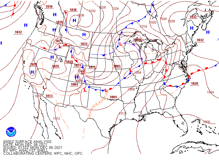
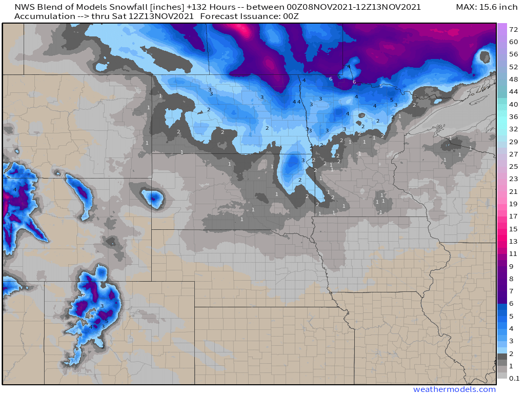
Low pressure will move across the Northern Plains and into southern Canada today, with heavy snow across the Dakotas and into Minnesota as well as parts of Manitoba and Ontario. Winter Storm Warnings are in effect on the US side of the border, with Snowfall Warnings on the Canadian side. Snowfall won’t be exceptionally heavy, but many locations will pick up 6-12 inches. gusts of 35-45 mph are possible, which may result in near-blizzard conditions at times. Snow should wind down tonight, but another system passing south of the region on Tuesday may bring more snow into the region.

Moderate to heavy snow is likely over the next few days in the Dakotas and parts of the Upper Midwest. Image provided by Weathermodels.com


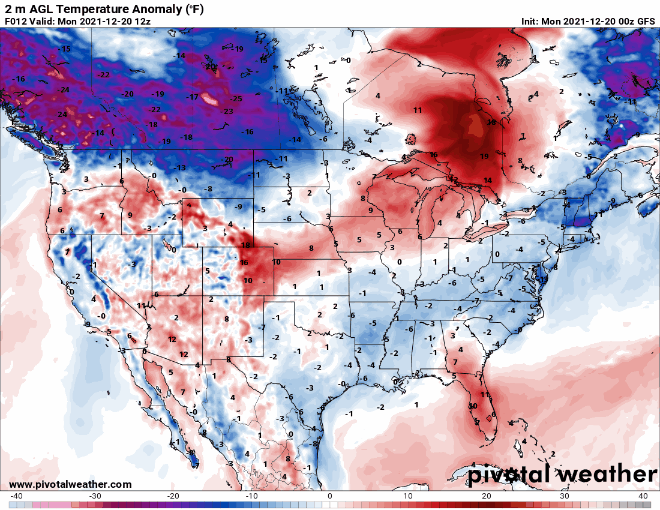
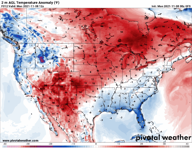
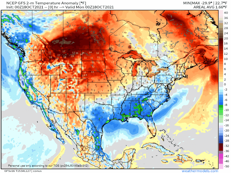
Later in the week, bitterly cold air will drop southward from Canada into parts of the Northern Plains and Northern Rockies, as well as the interior Northwest. Temperatures will be 15 to 25 degrees below normal across the interior Northwest, and as much as 20 to 40 degrees below normal in parts of Montana, the Dakotas, and northern Minnesota. Daytime highs will likely stay below zero for several days near the Canadian border, with low temperatures as low as 20 to 30 degrees below zero in parts of Montana and North Dakota.

The GFS shows the clash between bitterly cold air to the north and unseasonably warm air to the south right through the week. Loop provided by Pivotal Weather.


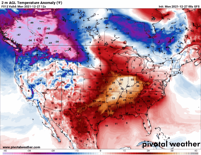
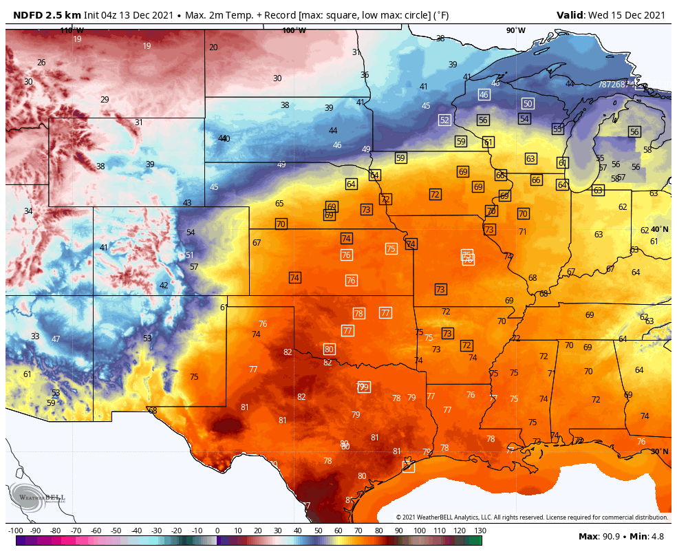
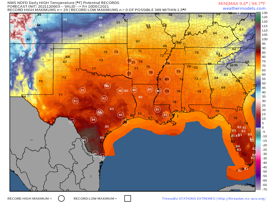
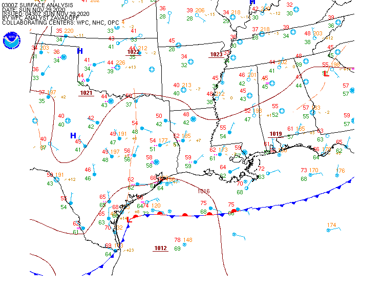
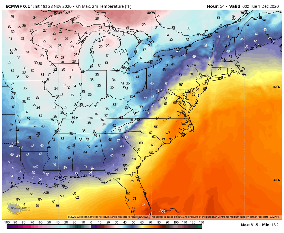
While bitterly cold air settles into the North, unseasonably warm weather is expected across the South. High temperatures will reach the 70s and 80s from Texas to the Southeast over the next several days, which is 20 to 30 degrees above normal. Dozens of record highs are likely to be set across the region.

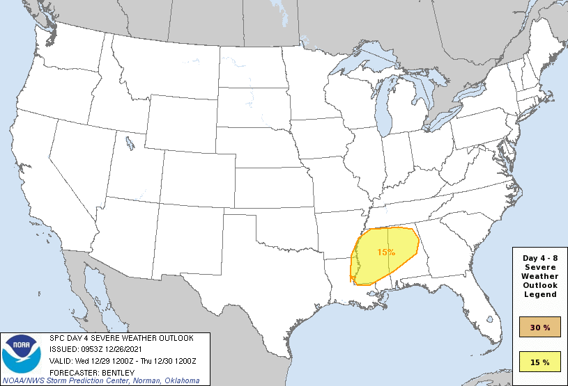
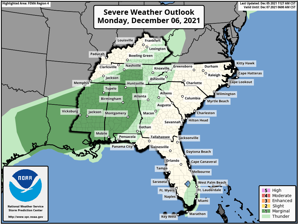
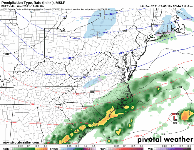
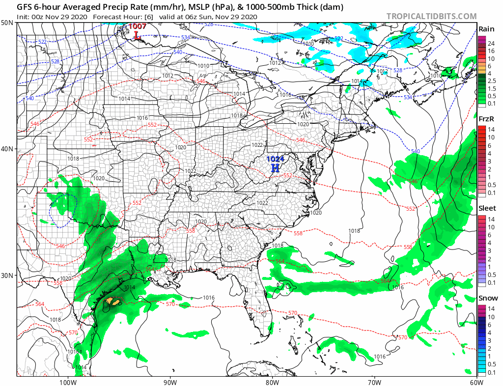
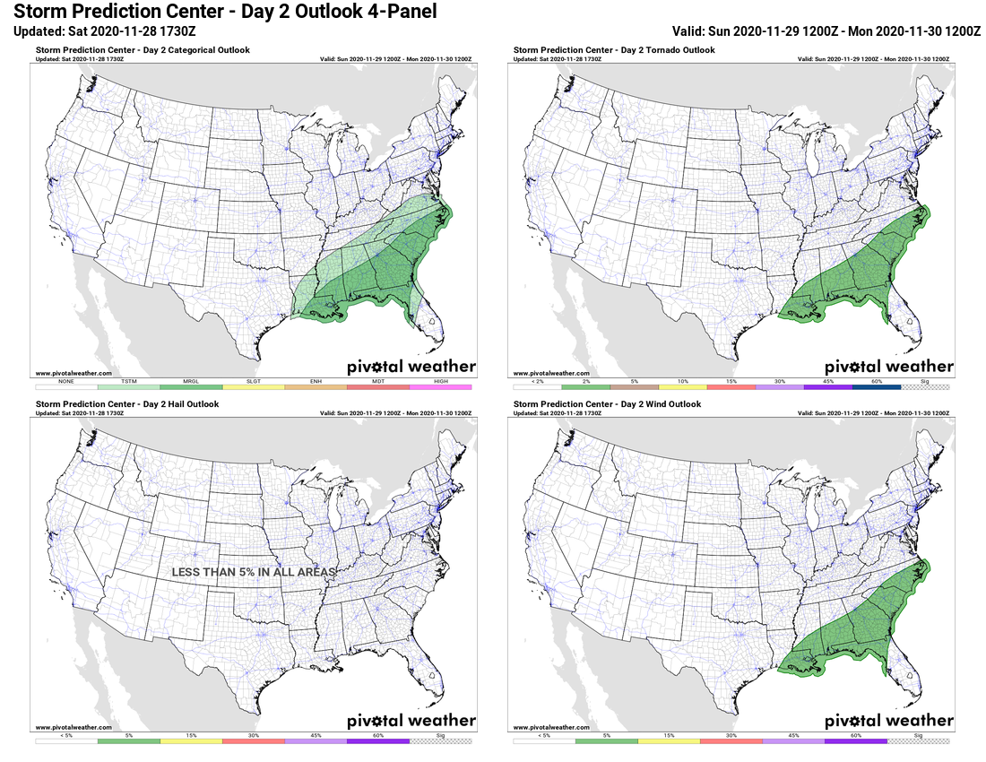
Low pressure will move into the Mississippi Valley by mid-week. With a warm, humid airmass in place, showers and thunderstorms are likely ahead of the system. Conditions could be ripe for some severe weather Wednesday into early Thursday, especially in parts of Louisiana, Alabama, and Mississippi.

Severe weather is possible across parts of the Lower Mississippi Valley and Deep South on Wednesday. Image provided by NOAA.


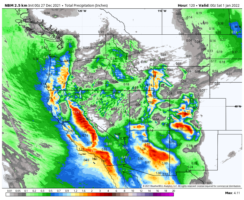
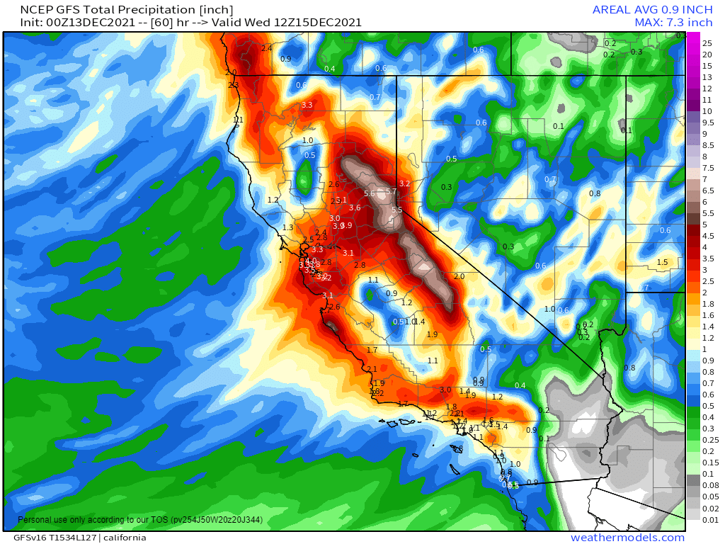
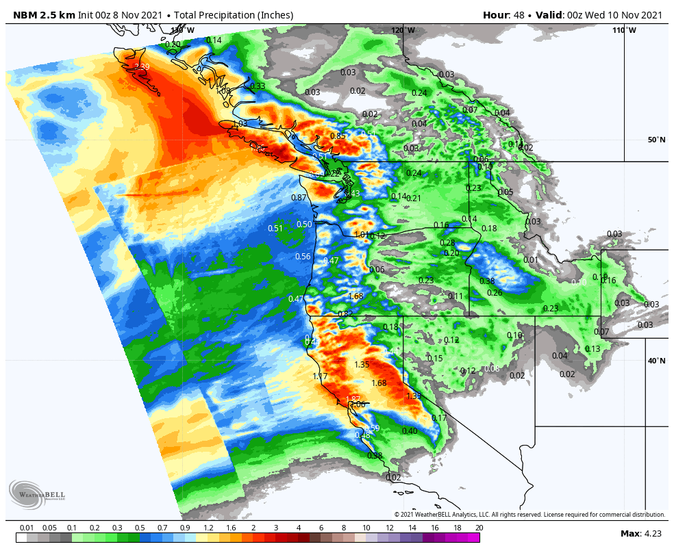
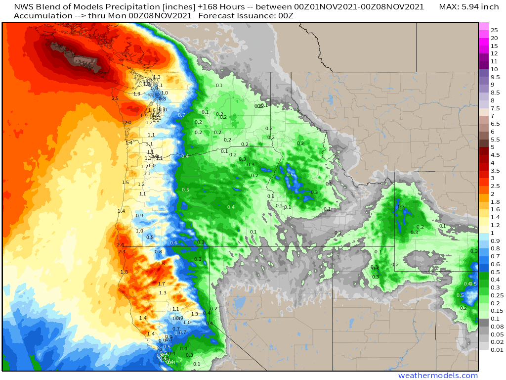
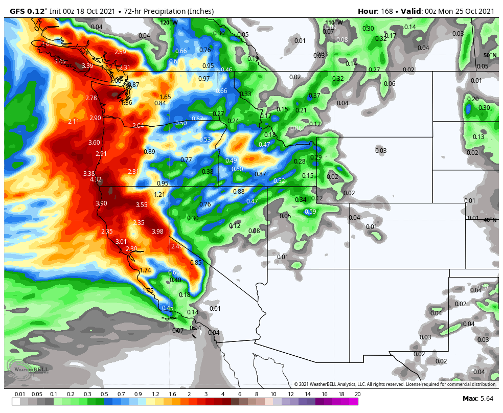
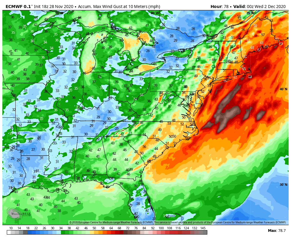
Meanwhile, out West, heavy rain and snow will continue across the region. With colder air in place, snow was observed right to the coastline in parts of Washington and Oregon on Sunday. The Seattle metropolitan area received 3-6 inches of snow, with 1-2 inches in the Portland area. As the low pressure area that produced the snow moves inland, more snow is likely, especially in the Cascades and Sierra Nevada, with rain into the lower elevations of California. Another system will follow right behind, with more heavy rain and mountain snow for the West Coast later this week. Rainfall totals of 1-3 inches and locally heavier will result in flooding in some areas, especially Southern California. Across the Sierra Nevada, snowfall totals of 3 to 6 feet are possible.

Heavy rain is expected across the West this week. Image provided by WeatherBell.


Right now, First Night festivities in New York City shouldn’t have any weather problems. In fact, it looks rather nice for revelers heading to Times Square to watch the ball drop. Right now, it looks like skies will be partly cloudy with temperatures around 40 degrees at midnight Friday night.

The Week Ahead: December 20-26, 2021

As we approach Christmas, a stormy pattern will continue across the West while another warmup is expected in the Plains.

Much of the US is quiet to start the week. Image provided by NOAA.


Rain and mountain snow will continue from the Northwest into the Northern Rockies today as low pressure moves across the region, but drier weather should settle in for Tuesday. After that, a series of low pressure areas will bring heavy rain and mountain snow to much of the West from Wednesday into the weekend. Rainfall totals of 2-4 inches and locally heavier are likely from British Columbia southward to southern California, which will likely lead to flooding in some areas by late in the week. The bigger story will be the snow in the mountains. The snowpack in the Sierra and Cascades is still below normal, but that is likely to change later this week. The potential exists for some places to receive as much as 5 to 10 FEET of snow over the next 7 days. This will result in travel problems crossing the mountains. By the end of the week, as colder air settles into the Northwest, snow is possible at the lower elevations, including the Seattle and Portland metropolitan areas.

Heavy snow is expected across the West later this week. Image provided by WeatherBell.


The other thing we’re watching is the return of warm weather to the Southern Plains and parts of the South and East later this week. By the middle of the week, temperatures will be 15 to 30 degrees above normal across the central and southern Plains. That warm will spread eastward, but will be modified a bit as it does so, with well above normal temperatures moving toward the East by the end of the week. A few records are possible across parts of the region. Another burst of warm air may move back into the Southern Plains and Texas next weekend.

Unseasonably warm weather returns to the Plains and the South this week. Loop provided by Pivotal Weather.


Meanwhile, bitterly cold air will build across western Canada this week. Temperatures could be as much as 25 to 50 degrees below normal in many areas later this week. Daytime highs of -30 to -40C are possible in parts of the Yukon, Northwest Territories and northern British Columbia. Some of that arctic air may spill southward into parts of Montana and the Dakotas for Christmas weekend.

The Week Ahead: December 13-19, 2021

Stormy weather will return to the West Coast over the next few days, and could spread into the Northern Plains later this week.

Low pressure is bringing unsettled weather to parts of the West. Image provided by NOAA.


A low pressure system will bring heavy rain, gusty winds, and mountain snow to much of the West over the next few days, with a second system following for Tuesday into Wednesday. It has been relatively dry across the region recently, so the rainfall is welcome, but amounts could be excessive in spots. Rainfall totals of 1-2 inches will be fairly widespread, but some locations, especially along the California coast, could see upwards of 3-5 inches of rain. Flood Watches are in effect for parts of the Golden State. The rain will be accompanied by strong winds, which will be widespread not only along the West Coast, but well inland into the Great Basin and parts of the Southwest. Wind gusts of 30-50 mph will be common, with Wind Advisories in effect for many locations. The storm will also produce heavy snowfall across the mountains of the West, especially the Sierra Nevada, where snowfall totals of 2-4 feet or more are expected.

Heavy rainfall is likely across much of the West over the next few days. Image provided by Weathermodels.com


By mid-week, the storm will redevelop east of the Rockies, and head northeastward across the Plains States toward the Upper Midwest. It may produce some light to moderate snow from the Central and Northern Plains into the Upper Midwest, but the bigger story will be the strong winds it generates across the Plains States and into the Mississippi Valley. The potential exists for widespread wind gusts of 50-70 mph or stronger. In the Northern Plains, when you combine the winds with the snowfall, blizzard conditions are possible in parts of the Dakotas and Minnesota Wednesday into Thursday. The system may also generate more severe weather ahead of it from the Mississippi Valley into the Ohio and Tennessee Valleys later Wednesday into Thursday.

Strong winds are possible across much of the nation’s midsection Wednesday into Thursday. Image provided by WeatherBell.


The other big story will be the temperatures on either side of this storm system. Unseasonably mild weather is already in place across much of the nation today, but that’s just a taste of what is coming. On Tuesday, temperatures will be 15-25 degrees above normal across most of the Plains States and the Mississippi Valley, with some records possible. Wednesday looks to be the warmest day in this region, with dozens of records expected. Temperatures will be well into the 60s and 70s, which is 15 to as much as 35-degrees above normal. The warm weather will shift into the eastern third of the nation for the latter half of the week, where temperatures will be 15-25 degrees above normal.

Dozens of record highs are likely across the Central US on Wednesday. Image provided by WeatherBell.


Behind the system, much cooler weather will settle into the West for Tuesday and Wednesday, with temperatures dropping to 8 to 15 degrees below normal. The cooler air will shift into the Northern Plains by Thursday, and across the rest of the Plains for the end of the week, with temperatures running as much as 10 to 20 degrees below normal.

The Week Ahead: December 6-12, 2021

The weather pattern is fairly active across the nation right now, and there are several areas we’re keeping an eye on.

The pattern has become very active over the past several days across the nation. Image provided by NOAA.


We’ll start off in the Pacific, where a low pressure system will bring a wide variety of impacts to the Hawaiian Islands today and tomorrow. Heavy rain will lead to widespread flooding across the islands, with strong winds also creating damage. Rainfall totals of 3-6 inches and locally heavier are expected through Wednesday. Flood Watches are in effect for much of the region. High Wind Warnings and Wind Advisories are also in effect, for sustained winds of 20-40 mph, with gusts of 50 to 60 mph possible. Along west-facing shorelines, waves of 8 to 12 feet will batter the beaches, where High Surf Advisories are in effect. If that wasn’t enough, across the higher summits of the Big Island, a Blizzard Warning remains in effect. Heavy snow will continue this morning with several more inches of accumulation possible. The snow will be accompanied by winds gusting as high as 80 mph, resulting in blizzard conditions.

Very heavy rain is likely across the Hawaiian Islands for the next few days. Image provided by weathermodels.com


Next, we’ll stay in the Pacific, but head northward to Alaska. A strong low pressure system is sitting just west of the the state early this morning, and it is having a significant impact on the region. Blizzard warnings are in effect for parts of western and southern Alaska. Heavy snow will be accompanied by winds gusting as high as 70 mph. The strong winds, combined with astronomically high tides, will result in flooding along the coast as well. Heavy snow is also likely for many locations, with up to 8-16 inches for many areas, and even more in some spots. Across the higher elevations, several feet of snow are expected. The only positive to this is that the brutally cold weather that much of the state experienced in November has been replaced by temperatures that are well above normal, though bitterly cold air will likely return behind this storm system.

A powerful storm system will impact Alaska over the next few days. Image provided by NOAA.


Across the Lower 48 States, the low pressure system moving into the Mississippi Valley this morning will garner the most attention today. It produced heavy snow in the Northern Plains and severe weather in the Mississippi Valley on Sunday. It will move into southern Canada today, dragging a strong cold front eastward. Ahead of the front, unseasonably mild air is expected across the East Coast, with temperatures topping 60 as far north as New England, and 70s into the Mid-Atlantic states. The warmth will be accompanied by some showers and gusty winds. Wind advisories are in effect for parts of the Northeast. Along the Gulf Coast and into the Lower Mississippi Valley, some strong to severe thunderstorms are possible ahead of the cold front. Some of the storms may produce strong winds, hail, heavy downpours, and possibly a few tornadoes.

Severe weather is possible in parts of the Lower Mississippi Valley today. Image provided by the Storm Prediction Center.


Another system will quickly follow for the Mid-Atlantic and Northeast on Wednesday. There’s quite a bit of uncertainty with the evolution of this second storm, but it has the potential to bring the first accumulating snow of the season to the I-95 corridor. While heavy snow seems unlikely at this point, some light to perhaps moderate accumulations are possible, which would result in travel issues for the heavily-populated region.

There is not a lot of agreement among the forecast models on what impacts the midweek storm will have and where they will be. Images provided by Pivotal Weather.


The other area we’re watching is the Southern Plains and Texas. After some record warmth over the past several days, cooler weather will settle in today and into Tuesday. However, another big warmup is expected later this week. Some record high temperatures are possible across the region on Thursday, but Friday looks to be the warmest day, with numerous records likely to be broken as highs soar well into the 70s and 80s, with 90s possible in southern Texas.

Numerous record high temperatures are in jeopardy by Friday as very warm air settles into the Southern Plains and Gulf Coast. Image provided by Weathermodels.com


On the flip side, very chilly air will settle into the Dakotas and Minnesota today in the wake of yesterday’s snowstorm. High temperatures will only reach the single numbers for parts of the region today, with some locations possibly staying below zero all day. Temperatures should start to moderate by tomorrow across the area.

The Week Ahead: November 8-14, 2021

A low pressure system moving into the West Coast today will impact the weather across much of the nation during the upcoming week.

The low pressure system currently in the Gulf of Alaska will be the big weather-maker this week. Image provided by NOAA.


Low pressure will move out of the Pacific and into the West Coast over the next day or two, spreading rain, some of it heavy, into the Pacific Northwest as well as northern and central portions of California. While this storm will be nowhere near the magnitude of some of the storms they’ve already seen this year, rainfall totals of 1-2 inches and locally heavier in some areas may result in localized flooding. The rian will be accompanied by gusty winds. Wind Advisories and High Wind Warnings have been issued for parts of the region. Wind gusts of 40-50 mph will be common, possibly resulting in damage and power outages in some areas. Across the higher elevations of the Cascades and the Sierra Nevada, heavy snow is likely, with many areas receiving more than a foot by the time everything winds down later Tuesday.

Heavy rain is expected across parts of the Northwest and California over the next day or two. Image provided by WeatherBell.


This system will weaken a bit as it moves into the Rockies by midweek, where several inches of snow is still expected. By Thursday, the system will intensify again as it moves into the Plains states. As it draws in some moisture from the Gulf of Mexico, it could produce some severe weather across parts of the Central and Southern Plains and into the Mississippi Valley ;ater Wednesday and Thursday. To the north, it will likely produce the first snowstorm of the season across the Dakotas and into parts of Minnesota late this week. Snowfall totals of 3-6 inches will be possible in parts of the region.

Several inches of snow may fall in parts of the Dakotas and Minnesota late this week. Image provided by Weathermodels.com


By the end of the week, the low pressure system will stall out near the Great Lakes, but ahead of it, a frontal system will draw moisture northward, bringing a period of heavy rain from the Tennessee and Ohio Valleys into the Mid-Atlantic states and the Northeast from Friday into Saturday.

The other thing we’re paying attention to this week will be the temperature swing we’re expecting. Temperatures will run 6-12 degrees above normal across parts of the Plains states eastward to the Great Lakes over the next couple of days before the core of the milder air shifts to the East Coast later this week. Meanwhile, behind the storm system, a pool of cooler air, with readings of 4-8 degrees below normal, will move into the West during the next 2-3 days. By the time that air moves into the Plains it will intensify  with temperatures running 6-12 degrees below normal across the Plains on Friday and further east by next weekend.

Mild air dominates the nation at the start of the week, but much cooler air eventually settles in. Loop provided by Pivotal Weather.


Taking a quick look ahead to the following week, there are some indications that a much cooler weather pattern may move into parts of the central and eastern US for the middle of the month.

The Week Ahead: November 1-7, 2021

After a fairly active week last week, a much more quiet pattern is expected for the upcoming week.

The most noteworthy feature on the weather map this morning is the strong cold front from the Great Lakes to Texas, Image provided by NOAA.


The biggest thing we’re keeping an eye on this week is the cold air that will spread across the eastern two-thirds of the nation. A strong cold front will move off the East Coast Monday morning, with the tail end of the front stalling out from the Carolinas to northern Texas. Behind this front, much cooler air has already settled into parts of the Plains states and Mississippi Valley, and it will continue to spread eastward. A series of weak cold fronts dropping out of Canada will help to usher progressively cooler into parts of the Northeast and Mid-Atlantic states as well. Temperatures will be 6-12 degrees below normal from the Northern and Central Plains into parts of the Upper Midwest for Monday and Tuesday, with the core of the colder air shifting into the region from the Southern Plains into the eastern Great Lakes for Wednesday into Friday, and the East Coast next weekend. A few record lows may be set, but widespread records are not anticipated. However, with this cold airmass settling in, the first frost and/or freeze of the fall will be possible from parts of the Deep South into the Southeast and Mid-Atlantic states later this week.

The GFS model shows the progression of the colder air across the nation over the next several days. Image provided by Weathermodels.com


Meanwhile, in the Atlantic, we’re entering the final month of hurricane season, and although October was quiet for the most part, November is not starting off that way. The storm system that produce heavy rain and significant wind damage across the Mid-Atlantic and Northeast last Tuesday and Wednesday moved out to sea and passed south of Atlantic Canada over the past several days. During the weekend it turned southward, moved over warmer water, and began to transition from a cold-core system to a warm-core system. Early Sunday it was designated as Subtropical Storm Wanda. It is in the middle of the Atlantic, nearly 1000 miles west of the Azores with maximum sustained winds near 50 mph. While it remains over marginally warmer waters, it may complete the transition into a tropical system and strengthen a bit more over the next day or two. Later this week, the most likely scenario is for it to head northeastward over colder water, transition back into an extratropical system, possibly bringing some rainfall and gusty winds to the British Isles next weekend. However, there are some models that show the storm turning back toward the south, and possibly impact the Azores by next weekend.

Forecast model tracks for Subtropical Storm Wanda. Image provided by WeatherBell.


Elsewhere, as is usually the case as we get into this time of year, a series of storm systems will bring heavy rain and mountain snow to parts of the Pacific Northwest and British Columbia, as well as parts of northern California. None of these systems will be as extreme as the storm that impacted California last week, but they will bring beneficial rainfall to the region.

Beneficial rain is expected across the Northwest later this week. Image provided by Weathermodels.com


The only other item of note for the week ahead is the potential for the first snowflakes of the season later this week east of the Great Lakes and into the higher elevations of the Northeast and New England. Any accumulations would be light, but they would be (in most cases), the first snow of the season, which is noteworthy in and of itself.

The Week Ahead: October 18-24, 2021

We’re keeping an eye on a couple of things for the upcoming week across the nation.

First, we’ve got a low pressure area that will move across the Great Basin and into the Rockies today and Tuesday, before it heads toward the northern Plains and Upper Midwest. While this system will likely produce snow across the higher elevations (parts of Wyoming could see more than a foot), the bigger story with the system is the temperatures both ahead of it and behind it.

Parts of Wyoming could see more than a foot of snow over the next few days. Image provided by the College of DuPage.


Temperatures are likely to run 15-20 degrees above normal across the Northern Plains today ahead of the system, shifting to the northern Great Lakes Tuesday. While these readings aren’t likely to set any records, they will be quite mild for mid-October. By the middle of the week, the warm air will settle into the Northeast, where temperatures will be 10-15 degrees above normal for Wednesday and Thursday. Behind the storm, temperatures will be 15-25 degrees below normal across interior California and Nevada today. That cold air will shift into the Rockies on Tuesday, where temperatures will still be 15-20 degrees below normal. As the core of the colder air moves into the Northern Plains on Wednesday, temperatures will be 10-18 degrees below normal, a significant change from what that region will experience today.

The GFS model shows the temperature anomalies over the next few days. Loop provided by Weathermodels.com


The other item we’re keeping an eye on are the twin low pressure areas that will impact the West Coast Friday and next Sunday. Heavy rain is expected into at least northern California, with the possibility of rain falling as far south of Los Angeles. Rainfall totals of 1-3 inches are possible along the coastal plain from British Columbia into Northern California, possibly even into the Bay Area. Across the higher elevations of the Cascades and Sierra Nevada, heavy snow is likely. Many locations could see more than a foot of snow.

Heavy rain is expected across the West Coast at the end of the week and the weekend. Image provided by WeatherBell.


Elsewhere, we’re not expecting much significant weather across the rest of the nation, but one other thing we’ll keep an eye on. The cooler air moving into the Plains for mid-week will make its way into the Northeast for next weekend. Some of the models are showing the possibility for some lake-effect snow downwind of Lakes Ontario and Erie toward Sunday as gusty west winds bring much cooler air across the still-warm lakes.

Changes High Up in the Polar Region Will Control Our Mid-Winter Weather

The chart below shows a time series of the polar atmosphere from top to bottom (red is high pressure and warmer temperatures and blue low pressure and cold arctic temperatures). October previewed a December/January polar warming now underway.

That event, called a Sudden Stratospheric Warming, increases surface pressures and atmospheric temperatures in the polar atmosphere. This affects one of the phenomena we watch closely in winter called the Arctic Oscillation.

The Arctic Oscillation (AO) is a large-scale mode of climate variability featuring large- scale differences from the polar regions to mid-latitudes. The Atlantic extension of the AO called the North Atlantic Oscillation (NAO) is especially important for the Eastern United States and Western Europe. The positive AO (left side of below graphic) and NAO modes produce more westerly winds in mid latitudes that bring milder ocean air into North America from the Pacific and into Europe from the Atlantic. The negative mode (right side) sees the flow pattern buckle and pushes cold air south to middle latitudes affecting Russia, Europe and North America.

It has been a decade or so since the last such a strong Negative AO event (2009/10 and 2010/11).

The most impressive winter 2009/10 was an El Nino and its winter AO beat out the memorable 1976/77 winter for the most negative AO since 1950.

Look at the extensive polar warming and off the scale AO that winter.

The very negative AO led to record snows (a blitz that got the name Snowmaggedon) for the Mid-Atlantic, a region where Negative AO/NAO El Ninos mean business.

The winter ended with a record snow month in New York City with 36.9 inches in March.

The next winter (2010/11) was a La Nina and December and January had a negative AO though without a Sudden Stratospheric Warming. The snows were big again but were further north. New York City again was hit hard with 36 inches in January. The winter there ended up with 61.0, 3rd highest since the 1870s.

See the negative AO in December and January in 2010/11.

The AO and NAO and the cold was aided by Eyjafjallajokull volcano in Iceland on 2010, which continued the string of high latitude eruptions that started in 2007. High latitude volcanism has been shown to lead to negative AO/NAO blocking patterns and snowstorms in Europe and the eastern U.S.

The Central England Temperature record is one of the longest continuous temperature record in the world, extending back to the Little Ice age in 1659. December 2010 was the coldest December in 120 years with an average of -0.7C just short of the record of -0.8C recorded in December 1890. It was the Second Coldest December Temperature in the entire record (352 years).

In addition to the cold, heavy snow hampered travel by air, rail, and road. In Ireland, this was the coldest start to winter in 130 years, when general records began. According to Met Eireann, Ireland’s meteorological service, December was the coldest month ever on record. County Mayo recorded low temperatures of -17.2C (+1F).

THIS JANUARY

The US model GFS is interesting later week 2 as true arctic air invades as pressures build in the arctic and sub-arctic.

The North Atlantic Oscillation is an extension of the AO. Usually they are both either positive or negative. We have documented how a negative NAO affects snow in Boston and Washington DC.

Stratospheric warming events typically last 30 days or so. When it fades, the trough should retrogress west like most La Ninas. Until then expect some harsh winter challenges. Climatology favors it. Since 1956, big December snow events were followed by 1 to 4 more such storms those winters.


The Monster December Snowstorm

Snowfall totals from the storm of December 16-17, 2020 Image provided by NOAA.


Satellite photo of East Coast snowstorm from December 17, 2020. Image provided by NOAA.


The storm that impacted much of the Northeast earlier this week had an amazing band of very heavy snow fall into arctic air.

Observers in cities and towns in PA, NY and New England:

  • 19 locations reported over 40 inches
  • 126 locations reported over 30 inches
  • 219 reported over 24 inches
  • 456 reported over 12 inches.

It is likely to make the NESIS list.

What is NESIS? NWS describes it:

While the Fujita and Saffir-Simpson Scales characterize tornadoes and hurricanes respectively, there is no widely used scale to classify snowstorms. The Northeast Snowfall Impact Scale (NESIS) developed by Paul Kocin and Louis Uccellini of the National Weather Service (Kocin and Uccellini, 2004) characterizes and ranks high-impact Northeast snowstorms. These storms have large areas of 10 inch snowfall accumulations and greater. NESIS has five categories: Extreme, Crippling, Major, Significant, and Notable.

The index differs from other meteorological indices in that it uses population information in addition to meteorological measurements. Thus NESIS gives an indication of a storm’s societal impacts. This scale was developed because of the impact Northeast snowstorms can have on the rest of the country in terms of transportation and economic impact.

NESIS scores are a function of the area affected by the snowstorm, the amount of snow, and the number of people living in the path of the storm. The diagram below illustrates how NESIS values are calculated within a geographical information system (GIS). The aerial distribution of snowfall and population information are combined in an equation that calculates a NESIS score which varies from around one for smaller storms to over ten for extreme storms. The raw score is then converted into one of the five NESIS categories. The largest NESIS values result from storms producing heavy snowfall over large areas that include major metropolitan centers. For details on how NESIS scores are calculated at the National Centers for Environmental Information, see Squires and Lawrimore (2006).

Example of how the NESIS Category for a storm is determined. I age provided by NOAA.


The Northeast Snowfall Impact Scale (NESIS)

Overview

While the Fujita and Saffir-Simpson Scales characterize tornadoes and hurricanes respectively, there is no widely used scale to classify snowstorms. The Northeast Snowfall Impact Scale (NESIS) developed by Paul Kocin and Louis Uccellini of the National Weather Service (Kocin and Uccellini, 2004) characterizes and ranks high-impact Northeast snowstorms. These storms have large areas of 10 inch snowfall accumulations and greater. NESIS has five categories: Extreme, Crippling, Major, Significant, and Notable. The index differs from other meteorological indices in that it uses population information in addition to meteorological measurements. Thus NESIS gives an indication of a storm’s societal impacts. This scale was developed because of the impact Northeast snowstorms can have on the rest of the country in terms of transportation and economic impact.

NESIS scores are a function of the area affected by the snowstorm, the amount of snow, and the number of people living in the path of the storm. The diagram below illustrates how NESIS values are calculated within a geographical information system (GIS). The aerial distribution of snowfall and population information are combined in an equation that calculates a NESIS score which varies from around one for smaller storms to over ten for extreme storms. The raw score is then converted into one of the five NESIS categories. The largest NESIS values result from storms producing heavy snowfall over large areas that include major metropolitan centers. For details on how NESIS scores are calculated at the National Centers for Environmental Information, see Squires and Lawrimore (2006).


Table 1: NESIS categories, their corresponding NESIS values, and a descriptive adjective:
CATEGORY NESIS VALUE DESCRIPTION
1 1—2.499 Notable
2 2.5—3.99 Significant
3 4—5.99 Major
4 6—9.99 Crippling
5 10.0+ Extreme


Table 2: Ranks 64 high-impact snowstorms that affected the Northeast urban corridor.
RANK START END NESIS CATEGORY DESCRIPTION MAP
1 1993-03-12 1993-03-14 13.20 5 Extreme view
2 1996-01-06 1996-01-08 11.78 5 Extreme view
3 1960-03-02 1960-03-05 8.77 4 Crippling view
4 2016-01-22 2016-01-24 7.66 4 Crippling view
5 2003-02-15 2003-02-18 7.50 4 Crippling view
6 1961-02-02 1961-02-05 7.06 4 Crippling view
7 1964-01-11 1964-01-14 6.91 4 Crippling view
8 2005-01-21 2005-01-24 6.80 4 Crippling view
9 1978-01-19 1978-01-21 6.53 4 Crippling view
10 1969-12-25 1969-12-28 6.29 4 Crippling view
11 1983-02-10 1983-02-12 6.25 4 Crippling view
12 1958-02-14 1958-02-17 6.25 4 Crippling view
13 1966-01-29 1966-01-31 5.93 3 Major view
14 1978-02-05 1978-02-07 5.78 3 Major view
15 2007-02-12 2007-02-15 5.63 3 Major view
16 2010-02-23 2010-02-28 5.46 3 Major view
17 2015-01-29 2015-02-03 5.42 3 Major view
18 1987-01-21 1987-01-23 5.40 3 Major view
19 1994-02-08 1994-02-12 5.39 3 Major view
20 2011-01-09 2011-01-13 5.31 3 Major view
21 2011-02-01 2011-02-03 5.30 3 Major view
22 2014-02-11 2014-02-14 5.28 3 Major view
23 2017-03-12 2017-03-15 5.03 3 Major view
24 2010-12-24 2010-12-28 4.92 3 Major view
25 1979-02-17 1979-02-19 4.77 3 Major view
26 1972-02-18 1972-02-20 4.77 3 Major view
27 1960-12-11 1960-12-13 4.53 3 Major view
28 2010-02-04 2010-02-07 4.38 3 Major view
29 2013-02-07 2013-02-10 4.35 3 Major view
30 1969-02-22 1969-02-28 4.29 3 Major view
31 2010-02-09 2010-02-11 4.10 3 Major view
32 2006-02-12 2006-02-13 4.10 3 Major view
33 2014-01-29 2014-02-04 4.08 3 Major view
34 1961-01-18 1961-01-21 4.04 3 Major view
35 2009-12-18 2009-12-21 3.99 2 Significant view
36 1966-12-23 1966-12-25 3.81 2 Significant view
37 1969-02-08 1969-02-10 3.51 2 Significant view
38 1958-03-18 1958-03-21 3.51 2 Significant view
39 1967-02-05 1967-02-08 3.50 2 Significant view
40 2018-03-05 2018-03-08 3.45 2 Significant view
41 1982-04-06 1982-04-07 3.35 2 Significant view
42 2013-12-30 2014-01-03 3.31 2 Significant view
43 2018-03-11 2018-03-15 3.16 2 Significant view
44 2013-03-04 2013-03-09 3.05 2 Significant view
45 2013-12-13 2013-12-16 2.95 2 Significant view
46 2015-01-25 2015-01-28 2.62 2 Significant view
47 2007-03-15 2007-03-18 2.54 2 Significant view
48 2000-01-24 2000-01-26 2.52 2 Significant view
49 2000-12-30 2000-12-31 2.37 1 Notable view
50 1997-03-31 1997-04-01 2.29 1 Notable view
51 2018-01-03 2018-01-05 2.27 1 Notable view
52 2011-01-26 2011-01-27 2.17 1 Notable view
53 1956-03-18 1956-03-19 1.87 1 Notable view
54 2011-10-29 2011-10-30 1.75 1 Notable view
55 2018-03-01 2018-03-03 1.65 1 Notable view
56 2018-03-20 2018-03-22 1.63 1 Notable view
57 2009-03-01 2009-03-03 1.59 1 Notable view
58 2014-11-26 2014-11-28 1.56 1 Notable view
59 2014-12-09 2014-12-14 1.49 1 Notable view
60 1987-02-22 1987-02-23 1.46 1 Notable view
61 1995-02-02 1995-02-04 1.43 1 Notable view
62 2015-02-08 2015-02-10 1.32 1 Notable view
63 2014-01-20 2014-01-22 1.26 1 Notable view
64 1987-01-25 1987-01-26 1.19 1 Notable view

References:

  • Kocin, P. J. and L. W. Uccellini, 2004: A Snowfall Impact Scale Derived From Northeast Storm Snowfall Distributions.  Amer. Meteor. Soc.85, 177-194
  • Squires, M. F. and J. H. Lawrimore, 2006: Development of an Operational Snowfall Impact Scale. 22ndIIPS, Atlanta, GA.

December sees a pop climatologically speaking. It rises to a peak in February with a slow decline as spring approaches.

Breakdown of NESIS storms by Month


Weekly, the second week in December has had 3 such storms, Christmas week has had 5, mid January also has had 5, with 7 to 8 per week in late January to mid February. It drops off some through the first 3 weeks of March then chances are low into April.

Number of NESIS storms by week of the year.


Oceans play a role in the development of these storms. A warm Atlantic and also a warm pool in the Gulf of Alaska can combine and make big storms more likely.

Sea surface temperature anomalies across the world as of Friday December 17. Image provided by WeatherBell.
Number of NESIS storms by year when SSTs are warmer than normal in the Gulf of Alaska.


These conditions were common since 2007/08.

Number of NESIS storms by year over the past 12 years.


The last decade, when these conditions existed, was a blockbuster with a total of 29 NESIS events.

Number of NESIS storms by decade.

Severe Weather, Heavy Rain, Strong Winds, and Snow All Expected in the East

A rather potent storm system will bring a variety of weather to the eastern third of the United States over the next few days.

Low pressure is developing along a frontal system in southern Texas this evening. Image provided by the Weather Prediction Center.

Low pressure developed along a frontal system in southern Texas on Saturday, and it will slowly strengthen as it moves northeastward tonight and Sunday. As it strengthens, it will draw moisture northward from the Gulf of Mexico, while colder air continues to move southward behind the storm system. This will set the stage for a couple of rather active days across the Eastern third of the nation, with several different types of weather likely.

The GFS model shows the progression of the storm over the next few days. Loop provided by Tropical Tidbits.

The biggest threat initially will be severe weather. As the warm, moist air flows northward from the Gulf of Mexico and clashes with the colder air moving in behind the storm, strong to severe thunderstorms are possible. A few storms are possible overnight in parts of Texas and Louisiana, but the threat will shift into the Gulf Coast on Sunday, parts of the Southeast and the Carolinas Sunday night, and parts of the East Coast from Florida to the Mid-Atlantic states on Monday. Some of the stronger storms may produce heavy downpours, damaging winds, and possibly some tornadoes.

Strong to severe storms are possible from the Gulf Coast into the Carolinas on Sunday. Image provided by Pivotal Weather.

While severe weather is not common at this time of year, it is certainly not unheard of. In fact, Saturday marked the 32nd anniversary of one of the strongest tornadoes on record to hit North Carolina. On November 28, 1988, an F4 tornado tore an 84-mile path of damage across parts of North Carolina, including the city of Raleigh.

As the storm moves up the Appalachians it will bring unseasonably mild air to the East Coast, but also some heavy rainfall. Temperatures will be in the 60s and 70s across the Gulf Coast and Southeast on Sunday. By Monday, 60-degree readings will be possible as far north as southern New England, with some 70s into the Carolinas and parts of southern Virginia. The mild air may linger into Tuesday across parts of New England as well. While these temperatures are 10-20 degrees above normal, they will likely fall short of the record highs in most locations.

Monday will be a warm day by November standards up and down the East Coast. Image provided by WeatherBell.

The warm weather will be transported in by strong southerly winds ahead of the system. Sustained winds of 25-35 mph will be common up and down the East Coast. Many places could see wind gusts of 50-60 mph or stronger, which could lead to power outages as trees and wires come down.

Wind gusts in excess of 50 mph are possible across the East Coast ahead of the storm. Image provided by WeatherBell.

In addition to the warm weather, heavy rain is likely for much of the East. The warm, moist air being drawn northward from the Gulf of Mexico will be deposited up and down the East Coast later Sunday into Monday, and early Tuesday for parts of New England. Rainfall totals of 1-2 inches will be common, with some places possibly picking up 3 inches or more, especially in parts of eastern New England. While this will help put another significant dent in the long term drought that the region is experiencing, too much rain at once will likely lead to flooding in some areas.

Heavy rain is likely across the East Coast Monday into Tuesday. Image provided by Weathermodels.com

While all of this is going on ahead of the storm, a different scenario will be evolving on the storm’s back side. Colder air flowing southward from Canada will clash with the warm air, resulting in snow across parts of the Great Lakes and the Appalachians. The snow will be accompanied by gusty winds, lowering visibility in many locations, resulting in very hazardous driving conditions. While the snow won’t be exceptionally heavy, many places could receive upwards of 4-8 inches by the time everything winds down. Across the higher elevations of the Appalachians, even into the southern Appalachians, some heavier amounts are possible as well. As the systems gets caught under an upper-level low pressure system in southeastern Canada, it may produce some lake-effect snow into mid-week downwind of Lakes Erie and Ontario.

Accumulating snow is expected behind the storm system. Image provided by Pivotal Weather.

Once this system pulls away, things will quiet down across the East for a few days, but there are signs that another system could impact parts of the East next weekend.

Back to top