Henri Takes Aim at the Northeast

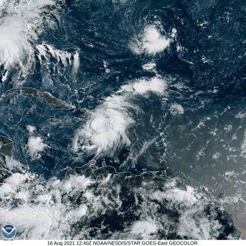
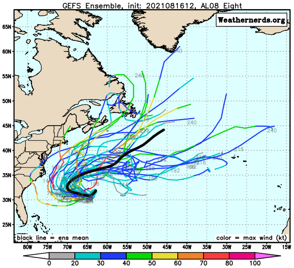
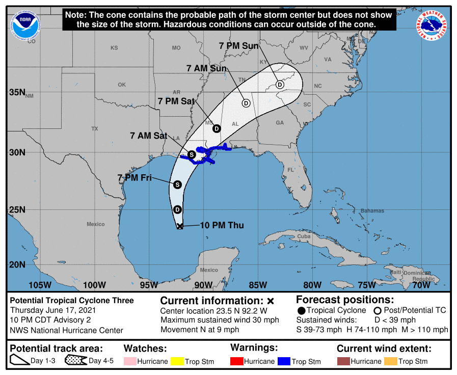
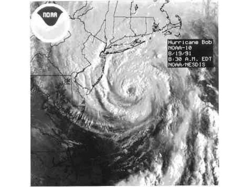
Tropical Storm Henri has made the long-awaited northerly turn and now is heading towards New England or Long Island.

Satellite loop of Tropical Storm Henri. Loop provided by NOAA.

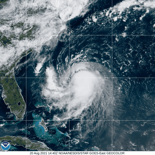
As of 11pm Friday, Tropical Storm Henri was centered about 615 miles south of Montauk, New York, moving toward the north at 9 mph. Maximum sustained winds were near 70 mph. Henri is expected to strengthen for the next 24 hours or so as wind shear begins to lessen and the storm remains over the warm waters of the Gulf Stream. Henri will likely become a hurricane on Saturday.

Watches and Warnings are in effect for a large portion of the Northeast coast. Image provided by the National Hurricane Center.

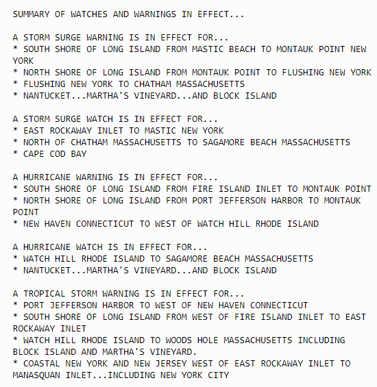
With a ridge of high pressure building in to the east of Henri, and an upper-level low pressure area developing over the Great Lakes, Henri will be steered northward for the next 24 hours, Beyond that, the upper-level low will start pull Henri northwestward and slow it down as it begins to approach Long Island or Southern New England. Since it will be over cooler water at that time, it will begin to weaken. Current forecasts show that Henri may still be a minimal hurricane at landfall, but there is also a good chance that it may weaken to a tropical storm by the time it reaches land.

The various members of the GFS and ECMWF Ensembles show landfall anywhere from New York City to Cape Cod. Image provided by Tomer Burg.

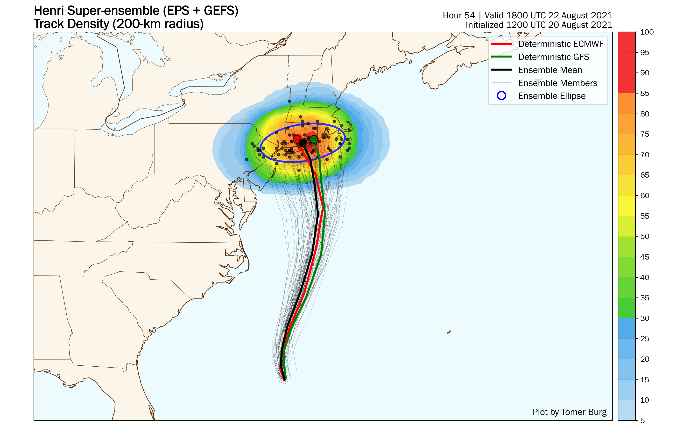
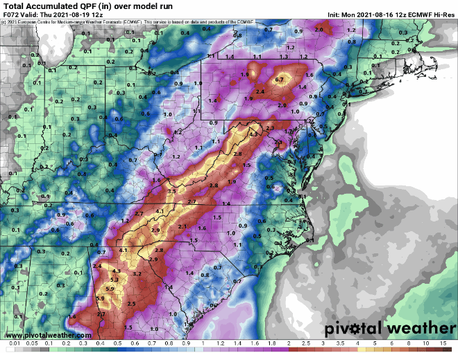
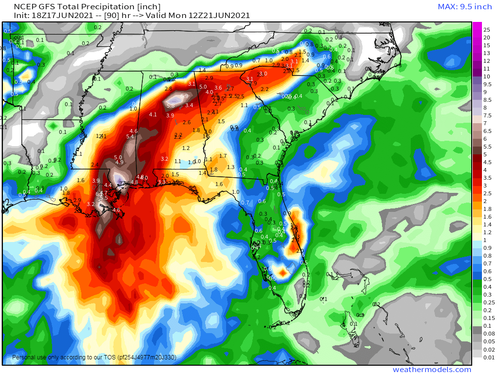
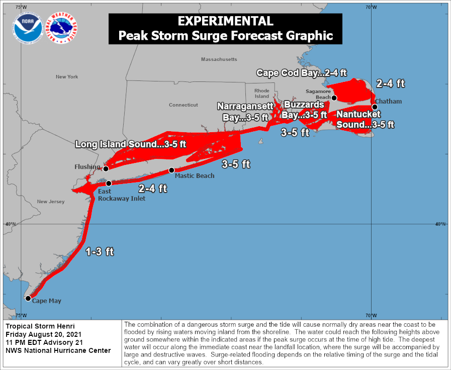
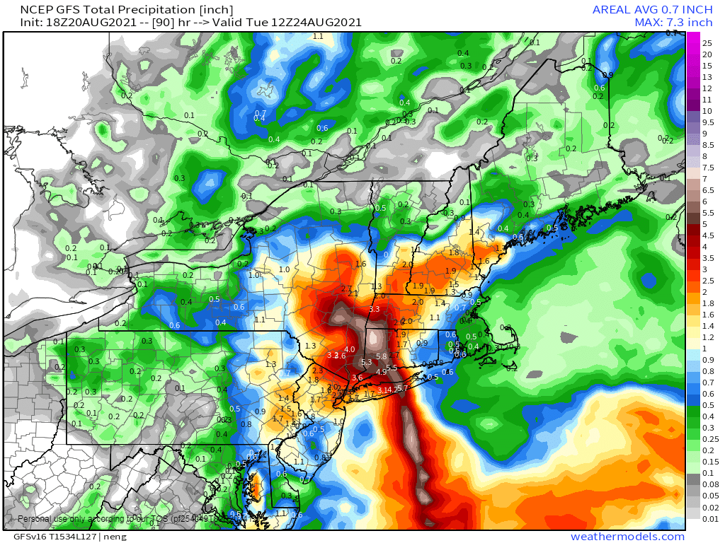
Although the exact track and intensity are still in question, the general impacts should be similar to most tropical systems that impact the Northeast. These systems tend to become lopsided, with the strongest winds mainly to the right of the center, and most of the rain shifting to the left of the track. The current forecast of a track towards eastern Long Island would mean that gusty winds and the highest storm surge would impact parts of Rhode Island and southeastern Massachusetts, including Cape Cod. The storm surge will be compounded by the fact that with a full moon on Sunday, tides will be astronomically high, exacerbating any storm surge flooding. The western track would also mean that the heaviest rain and greatest threat of freshwater flooding, would shift to Long Island, western portions of Connecticut and Massachusetts, and eastern New York.

Expected peak storm surge associated with Henri. Image provided by the National Hurricane Center.

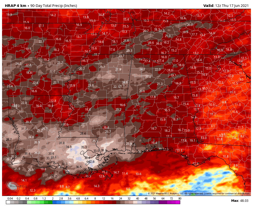
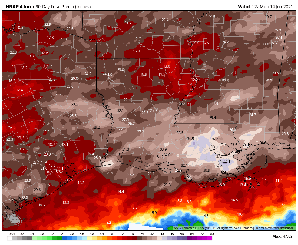
While the winds won’t be particularly strong across much of Southern New England, tree damage could be more extensive that you’d normally expect. It has been a very wet summer across the region, with many places receiving 10-20 inches since the beginning of July. As a result, the ground is saturated across much of the area, so it won’t take strong winds to knock trees over. It also will result in more extensive flooding in areas that receive heavy rain.

Rainfall totals of 4-8 inches are possible where the heaviest rain falls. Image provided by Weathermodels.com

As the steering currents weaken late Sunday and Sunday night, Henri or what’s left of it, may stall out across western New England or eastern New York, then eventually start moving eastward, bringing more rain to parts of central and northern New England. Conditions will improve from west to east on Monday as the storm departs and high pressure starts to build into the region.

Three Active Systems in the Atlantic, Two in the Pacific

As we get into the middle of August, there are now three active systems in the Atlantic and two more in the Pacific, and all but one are a threat to land.

Satellite loop showing Fred nearing the Florida Panhandle, Grace over Haiti, and TD 8 near Bermuda. Loop provided by NOAA.

The most immediate threat is Tropical Storm Fred. After sputtering over Cuba this past weekend, Fred emerged into the eastern Gulf of Mexico and has become better organized. As of early Monday afternoon, Fred was centered about 35 miles southwest of Apalachicola, Florida, moving toward the north at 10 mph. Maximum sustained winds have increased to 65 mph. Tropical Storm Warnings and Storm Surge Warnings are in effect for parts of the Florida Gulf Coast. Fred may strengthen a little more before it makes landfall late this afternoon. Once inland, it should rapidly weaken. The main threats from Fred are strong winds, heavy rain, and storm surge, along with the possibility of a few tornadoes.

Radar shows the center of Fred approaching the Florida Panhandle. Loop provided by Weathermodels.com

Fred will produce 4-8 inches of rain across parts of Florida and southern Georgia, with some locally heavier amounts. As it moves inland and weakens, the moisture will start to interact with a frontal system, bringing heavy rain to parts of the Southeast, Mid-Atlantic States, and the Appalachians. In these areas, rainfall totals of 3-6 inches and locally heavier will likely lead to flooding over the next few days.

Forecast models show the potential for heavy rain from the Southeast into the Mid-Atlantic states. Images provided by Pivotal Weather.

While Fred heads for Florida, Grace may be starting to get its act together near Haiti Grace brought heavy rain to parts of the northeastern Caribbean this weekend, but was very poorly organized. It looks a bit healthier this afternoon as it nears the south coast of Haiti. It was centered about 70 miles southeast of Port-au-Prince, Haiti early Monday afternoon, moving toward the west-northwest at 12 mph. It is still a tropical depression with maximum sustained winds near 35 mph. A Tropical Storm Warning is in effect for parts of southern Cuba and the Cayman Islands, while Tropical Storm Watches are in effect for Haiti, Jamaica, and parts of southern Cuba.

Grace is expected to continue on a general west to west-northwest course for the next few days. As it pulls away from Haiti late tonight, it should move over the warm waters of the northwestern Caribbean south of Cuba, and gradual strengthening is expected. The current forecast calls for it to be a strong tropical storm as it approaches the northern Yucatan Peninsula by the middle of the week. Beyond that, a track into the Gulf of Mexico seems likely at this point.

Forecast track for Tropical Depression Grace. Image provided by the National Hurricane Center.

Out in the central Atlantic, Tropical Depression Eight developed late Sunday night. As of early Monday afternoon, it was centered about 140 miles southeast of Bermuda, moving toward the south at 9 mph. Max sustained winds were near 35 mph. A Tropical Storm Watch is in effect for Bermuda. The system is expected to become a tropical storm later today or tonight as it turns westward and rides around a ridge of high pressure. Eventually, it will turn back to the north and northeast and head out into the open Atlantic. There is a slight chance that it could impact the East Coast, depending on how quickly it makes the turn. It should bring some rough seas to the coastal waters from the Carolinas to New England later this week.

Forecast track for Tropical Depression Eight from the various members of the GFS Ensemble. Image provided by Weathernerds.org.

In the Eastern Pacific, Hurricane Linda still has maximum sustained winds near 105 mph at midday. It was centered about 955 miles west-southwest of Cabo San Lucas, Mexico, and moving toward the west-southwest at 9 mph. Linda reached Category 4 strength over the weekend, but now is gradually weakening over open water. It should continue on a general west to west-northwest track this week while slowly weakening. It should pass well north and east of Hawaii late this week as a weakening extratropical system, with little impact other than some rough surf.

Model forecasts for the track of Hurricane Linda. Image provided by WeatherBell.

In the Western Pacific Ocean, Tropical Depression 16W remains fairly weak. It only has maximum sustained winds near 25 mph, and is centered about 180 miles east of Guam, moving toward the west at 18 mph. It will bring heavy rain and some gusty winds to the Northern Mariana Islands over the next 24 hours as it passes very close to Guam.

Forecast track for Tropical Depression 16W. Image provided by the Join Typhoon Warning center.

The system may start to strengthen once it gets past the Northern Marianas and turns a bit more toward the northwest. Some forecasts call for it to become a tropical storm, and possibly a typhoon by the end of the week. Where it will go is highly uncertain at this point. While the official forecast from the Joint Typhoon Warning Center has it heading towards Taiwan, various models have it continuing westward to the Philippines, continuing west-northwestward toward Taiwan and/or eastern China, or turning northward and heading toward Japan. It will have to be watched closely later this week.

Tropical Storm Fred Develops

The tropical disturbance that brought heavy rain to parts of the Lesser Antilles, Virgin Islands, and Puerto Rico over the past few days developed into Tropical Storm Fred late Tuesday night.

Satellite loop of Tropical Storm Fred. Loop provided by NOAA.

As of early Wednesday afternoon, Tropical Storm Fred was centered about 30 miles west of Santo Domingo, Dominican Republic, moving toward the west-northwest at 16 mph. Maximum sustained winds were near 45 mph, but some weakening is likely over the next 12-24 hours with the center over land. A Tropical Storm Warning remains in effect for much of the Dominican Republic, with Tropical Storm Watches in effect for parts of Haiti, eastern Cuba, the Turks and Caicos Islands, and the southeastern Bahamas.

The combination of the center crossing the mountainous terrain of Hispaniola and westerly wind shear will keep Fred weak for the next day or two as it heads west-northwestward across Haiti and close to the coast of Cuba. Whether the center stays offshore of Cuba or near or just onshore will have an impact on how much the storm starts to re-strengthen. It will produce gusty winds and heavy rain across Hispaniola, eastern Cuba and parts of the Bahamas, leading to flooding and mudslides. Rainfall totals of 3-6 inches and locally heavier are likely across these areas.

Model forecasts for the track of Tropical Storm Fred. Image provided by WeatherBell.

By late Friday or early Saturday, Fred will start to turn more toward the northwest as it rounds the edge of a large ridge of high pressure over the Atlantic. This should bring the storm across the Florida Keys early Saturday, and then into the eastern Gulf of Mexico. It should start to strengthen again over the warm waters of the Gulf as it heads toward the northern Gulf Coast. The current forecast from the National Hurricane Center calls for Fred to make landfall in the Florida Panhandle early Monday as a strong tropical storm. However, given the average errors in a typical forecast for a tropical system, it wouldn’t be a surprise if Fred was a hurricane by then. Landfall could also take place as far west as Louisiana if the northerly turn takes place a little later, or the system could turn earlier and impact southern or even southeastern Florida. A lot of these variables should become a bit clearer once Fred emerges from Hispaniola early Thursday. It does seem likely that heavy rain will impact at least parts of southern Florida this weekend, with flooding likely. Tropical Storm Watches will likely be issued for at least the Florida Keys, if not parts of southern Florida as well, late tonight or early Thursday.

Model forecasts for the intensity of Tropical Storm Fred. Image provided by Tropical Tidbits.

Fred is the only named storm in the Atlantic right, but there’s a tropical wave several hundred miles west-southwest of the Cabo Verde Islands that bears watching. That wave will make its way across the Atlantic over the next several days. It is disorganized at the moment, but conditions should become more favorable for development over the next few days. Some models show to potential for it to become a tropical depression as it nears the Lesser Antilles this weekend. This wave will be monitored closely over the next few days as it continues its trek westward.

Forecast tracks for the disturbance in the central Atlantic from the various members of the GFS Ensemble. Image provided by Weathernerds.org.

The Atlantic isn’t the only active basin at the moment. In the Eastern Pacific, Tropical Storm Kevin is a few hundred miles west-southwest of Baja California, but it is expected to dissipate over open water in the next few days. There is also Tropical Storm Linda, located a few hundred miles off the southwest coast of Mexico. Linda is expected to become a hurricane tonight or Thursday, but will head west-northwestward away from land for the next several days. In the Western Pacific, Tropical Depression 16W is located just west of the International Dateline, but should remain fairly weak as it heads westward over the next few days. It could impact a few islands, such as Enewetak, with squally conditions over the next few days, but in general, it isn’t much of a threat.

Elsa Heads Toward Western Florida

After bringing heavy rain to parts of the Caribbean and the Florida Keys over the past few days, Elsa is now setting its sights on the Big Bend area of Florida.

Satellite loop of Hurricane Elsa from Tuesday afternoon. Loop provided by NOAA.


As of 11pm EDT, Hurricane Elsa was centered about 65 miles southwest of Tampa, Florida, moving toward the north at 14 mph. Maximum sustained winds were near 75 mph, but Elsa may begin to weaken as it moves toward the Florida coastline overnight and on Wednesday. A variety of watches and warnings are in effect for the west coast of Florida, as well as the Atlantic coast from Georgia into North Carolina.

Summary of watches and warnings in effect Tuesday evening. Image provided by the National Hurricane Center.


As Elsa heads northward overnight and on Wednesday, heavy rain and gusty winds will rake western Florida. Rainfall totals of 3-6 inches and locally heavier will result in flooding in some areas, while wind gusts of 30-50 mph or more will result in damage in many locations. In addition, tornadoes are possible as some of Elsa’s bands move inland.


Elsa is expected to make landfall in the Big Bend area of Florida on Wednesday, then start to turn more toward the northeast, crossing southeastern Georgia and the Carolinas on Thursday, producing heavy rain and gusty winds across the region. Rainfall totals of 2-4 inches and locally heavier are expected, likely producing some flooding.

Expected rainfall through Friday. Image provided by WeatherBell.


Once Elsa moves off the Mid-Atlantic coast, it will move over the warm water of the Gulf Stream, which are marginally warm enough to support a brief period of strengthening once again, as some forecast models are indicating. Elsa should continue northeastward, passing close to or just south and east of Cape Cod on Friday as a weak tropical storm. This will bring a period of heavy rain and gusty winds to the region.

Model forecasts for the track on Elsa. Images provided by Weathermodels.com


Once it moves past New England, Elsa should become extratropical as it approaches Nova Scotia, with heavy rain likely over the weekend across Atlantic Canada as the system moves through.

Elsa Races Across the Caribbean

Less than 48 hours after it formed east of the Lesser Antilles, Hurricane Elsa is now racing across the eastern Caribbean.

Satellite loop of Hurricane Elsa. Loop provided by NOAA.


As of 2am Saturday, Hurricane Elsa was centered approximately 620 miles east-southeast of Kingston, Jamaica, moving toward the west-northwest at 29 mph. Maximum sustained winds are near 80 mph.

Hurricane Warnings are in effect for southern portions of the Dominican Republic and Haiti, as well as for the island of Jamaica, with Tropical Storm Warnings for the remainder of the Dominican Republic and Haiti. A Hurricane Watch is in effect for parts of eastern Cuba, and a Tropical Storm Watch is in effect for parts of the Cayman Islands.

Watches and Warnings associated with Hurricane Elsa. Image provided by the National Hurricane Center.


Elsa could strengthen a bit on Saturday, but for the most part, weakening is forecast. Some dry air got entrained in the circulation late Friday, okus the current rapid forward speed with both serve to inhibit any further strengthening, Although Elsa is expected to slow down over the next 24 hours, a turn more toward the northwest is expected. This will bring the storm closer to Hispaniola, where the mountainous terrain could disrupt the circulation as well.

Model forecasts for the track of Hurricane Elsa. Image provided by Weathermodels.com.


Current forecasts bring the center of the storm close to southern Haiti Saturday night, then toward southeastern and southern Cuba on Sunday. The intensity of the storm will be determined partially by the track the storm takes. The longer the circulation center stays over water, the better chance that the storm is stronger.

As the storm slows down, it increases the chances for heavy rainfall across southern portions of Hispaniola, eastern and southern Cuba, and parts of Jamaica. Rainfall totals of 6-12 inches and locally heavier will lead to flooding and mudslides.

Elsa will bring heavy rainfall to portions of the Caribbean. Image provided by Weathermodels.com


Elsa is expected to cross Cuba on Monday while turning northward. Given that this is already three days out, the uncertainty in the forecast becomes much large. A track towards Florida seems likely, but is far from definite at this point. Several models bring the storm up the west coast of Florida, while many others bring it up the east coast or even over the Bahamas. How strong the storm is at this point is also highly uncertain. Residents from the central Gulf Coast all the way to the Carolinas should keep tabs on the system this weekend, as it has the potential to impact anywhere within that range by the early to middle portion of next week.


As Elsa crossed the Windward Islands on Friday, it produced wind gusts as high as 86 mph on Barbados and 79 mph on Saint Lucia, making it the first hurricane of the 2021 season. This is the earliest in the season that a storm has hit Barbados, and it is the 2nd earliest Hurricane ever in the eastern Caribbean, trailing only an unnamed storm from 1933.

Tropical Threat in the Gulf

A developing system in the Gulf of Mexico will bring heavy rain and flooding to parts of the Gulf Coast and Deep South over the next few days.

Satellite loop of the developing tropical system in the Gulf of Mexico. Loop provided by NOAA.


A broad area of low pressure has been meandering around in the Bay of Campeche for much of this week. The system started moving northward on Thursday and is getting better organized. Conditions are favorable for further development as the system continues moving northward on Friday. The system is expected to produce tropical storm conditions for part of the Gulf Coast on Friday, and with that expectation, the National Hurricane Center declared the storm to be Potential Tropical Cyclone Three Thursday afternoon. This allowed the issuance of a Tropical Storm Warning from Intracoastal City, Louisiana to the Alabama/Florida border. This includes Lake Maurepas, Lake Pontchartrain, and the New Orleans Metropolitan area.

As of 11pm EDT, the system was centered about 435 miles south of Morgan City, Louisiana, moving toward the north at 9 mph. It is expected to speed up on Friday, with the center expected to make landfall in southern Louisiana early Saturday morning. The system is expected to continue organizing, and could become a tropical depression or storm on Friday. If it does reach tropical storm strength, it will be named Claudette.

Forecast track for Potential Tropical Cyclone Three. Image provided by the National Hurricane Center.


While this system will bring some gusty winds and a minor storm surge to coastal areas, flooding from heavy rain is by far the biggest threat. The storm will likely produce 4 to 8 inches of rain across portions of the Gulf Coast and inland across the Deep South, with isolated totals of 10 to 15 inches possible.

Heavy rain is expected across the Gulf Coast and Deep South this weekend. Image provided by Weathermodels.com


It’s been a very wet spring across this region already, so additional heavy rainfall is not good news. Over the past 90 days much of the area has received 15 to 30 inches of rain, with as much as 45 inches in parts of southeastern Louisiana. This is 1.5 to 2.5 times the normal amount that usually falls. This has led to flooding across the area at times, and additional rain this weekend will produce more flooding. Flash Flood Watches have already been issued for parts of the area.

Much of the Deep South and the Gulf Coast has received 20-40 inches of rain over the past 90 days. Image provided by WeatherBell.


Louisiana is no stranger to tropical cyclones, but during the record-setting 2020 hurricane season, Louisiana suffered a direct-hit from a record 5 different storms. Tropical Storm Cristobal, Hurricane Laura, Tropical Storm Marco, Hurricane Delta, and Hurricane Zeta all made landfall in the Pelican State, causing billions of dollars in damage. Recovery efforts still continue to this day, so the heavy rain this spring has not been welcome.

Louisiana was assaulted by five tropical systems in 2020. Image provided by NOAA.


Elsewhere, the Atlantic remains quiet, with no systems expected over the next week. In the Eastern Pacific, a tropical depression is expected to develop just off the south coast of Mexico in the next few days. While the system is expected to remain weak, it will bring heavy rain to southwestern Mexico this weekend. Rainfall totals of 10-20 inches will likely produce flooding and mudslides across the area.

Tropical Activity in the Atlantic

We’re only two weeks into Hurricane Season, and the peak of the season is still three months away, but activity is starting to ramp up in the Atlantic.

Satellite loop of Tropical Storm Bill from late Monday afternoon. Loop provided by NOAA.

Tropical Depression Two developed off the North Carolina coast on Monday. As of 11pm Monday, it had strengthened into Tropical Storm Bill, and was centered about 335 miles east-northeast of Cape Hatteras, NC, moving toward the northeast at 23 mph. Maximum sustained winds were near 45 mph. The system remains weak, and there is not a lot of thunderstorm activity with it at the moment, but it is moving over the warm waters of the Gulf Stream, so there is a small window for the system to intensify over the next 12-18 hours. After that, it will be moving over colder water, and will weaken before bringing some gusty winds and rainfall to parts of Newfoundland and possibly Nova Scotia later this week.

Forecast track for Tropical Storm Bill. Image provided by the National Hurricane Center.

In the eastern Atlantic, a strong tropical wave has moved off the west coast of Africa, passing south of the Cabo Verde Islands tonight. While this system may develop a little over the next day or two, the combination of unfavorable upper-level winds and dry air will limit any development once the system reaches the central Atlantic Ocean. Once we get a little deeper into hurricane season, conditions should become more favorable as more and more waves roll off of Africa and cross the Atlantic. Some of these storms historically have become powerful systems, as they have plenty of time to develop over open water.

Saharan dust crossing the Atlantic will limit any storm development. Loop provided by Weathermodels.com

In the Bay of Campeche, a cluster of showers and thunderstorms continues to meander around associated with a broad area of low pressure. While this will produce some heavy rain across parts of Mexico and Central America, it is not expected to develop over the next few days. By late in the week, the system will start drifting northward, and conditions will become more favorable for development. It could become a tropical depression by the weekend, then it may head toward Louisiana or Texas.

Satellite loop of the Gulf of Mexico, including the Bay of Campeche. Loop provided by NOAA.

While it’s still a little early to speculate on any potential track or strength for this system, most of the models are in agreement that most of the rain from this system will head towards Louisiana. Much of southern Louisiana and Mississippi has received 30 to 45 inches of rain over the past 90 days, which is more than twice the normal amount they receive in that time frame. This has led to widespread flooding in areas still attempting to recover from several direct hits during the 2020 hurricane season. A tropical system, even a weak one, could drop 10 or more inches of rain on this area, leading to even more flooding.

Much of the Lower Mississippi Valley has been deluged with more than 30 inches of rain over the past 90 days. Image provided by WeatherBell.

Elsewhere, the only other active system in the tropics is Tropical Depression Carlos in the Eastern Pacific, but it is expected to dissipate on Tuesday over open water.

Hurricane Season Begins Today

Earlier this month, Tropical Storm Ana brought some breezy and damp conditions to Bermuda, marking the 7th year in a row that we had at least one named tropical system in the Atlantic before the “official” start of Hurricane Season, which runs from June 1 through November 30. After a record-setting hurricane season in 2020, it looks like another busy season lies ahead.
The list of Hurricane names for the 2021 season. Image provided by NOAA.
  While we might quibble with some of the systems that got named last year, there was no denying the fact that it was a very active season. We had a total of 30 named storms, which set a record. Of those 30, 13 became hurricanes, and 7 were major hurricanes. The seven major hurricanes tied 2005 for the most in a single season. We also had a record 12 storms make landfall in the United States, including FIVE in Louisiana alone.
The 2020 Hurricane Season was a record-setting one across the Atlantic Basin. Image provided by the National Hurricane Center.
  An early start is not always a harbinger of what the season will bring. NOAA issued their seasonal hurricane outlook on May 20, and it calls for a 60 percent chance for an above normal season, a 30 percent chance for a normal season, and a 10 percent chance for a below normal season. Many of the other hurricane outlooks issued by various outlets are also expecting a busy season, due to a number of factors. An average season consists of 14 named storms, of which 7 become hurricanes and 3 become major hurricanes (Category 3 or higher on the Saffir-Simpson scale). NOAA’s forecast for this season calls for 13-20 named storms, 6-10 hurricanes, and 3-5 major hurricanes. The Tropical Meteorology Project at Colorado State, the first group to forecast how active a hurricane season would be, originally led by Dr. Bill Gray, will issue their forecast on June 3. Their initial forecast from April called for 17 named storms, 8 hurricanes, and 4 major hurricanes. They also pegged the chance at a storm making landfall in the United States at 69% (52% is the average in any given year), and the odds of a storm making landfall along the East Coast at 45% (31% is the average). The last 6 seasons have all featured above normal activity across the Atlantic. Despite the early start for the past several years, the average date for the first named storm in the Atlantic is still in late June or early July. Over 97% of all named storms in the Atlantic form between June 1 and November 30. Like our first storm this year, most early season storms tend to be on the weaker side. A hurricane hasn’t made landfall in the United States before July 1 since Hurricane Bonnie came ashore as a minimal hurricane near the Texas/Louisiana border on June 26, 1986.
Based on climatology, the most likely spots for an early season storm are in the Gulf of Mexico or northwest Caribbean. Image provided by the National Hurricane Center.
  A busy season does not always mean that multiple storms (or any storms for that matter) will impact the United States, though last year saw much of the Gulf Coast and East Coast threatened by tropical systems. In 2010, 19 named storms were observed in the Atlantic, 12 of them became hurricanes, and 5 were major hurricanes. Only one storm made landfall in the United States, and that was Bonnie, which was a minimal tropical storm at landfall. In 1990, there were a total 14 named storms, 8 of them hurricanes and 1 major hurricane. Not a single one of them made landfall in the United States. On the flip side, an inactive year doesn’t mean much for landfall probabilities as well. Only 7 named storms formed in 1992, and the 1st one didn’t develop until August 16. That storm, however, was named Andrew, and it made landfall just south of Miami as a category 5 storm. It only takes one storm to ruin your entire year. For residents of New England and Long Island, one area that was mostly spared last season aside from Tropical Storm Isaias, you should always pay attention when a storm is nearing the Bahamas, as those are the ones that have the potential to impact the region, and that area is very overdue for a system to make landfall Using data back to 1851, here are some stats that show how overdue that area is:
  • Since 1851, 36 storms of tropical storm strength of greater have made landfall in New England or Long Island, an average of one every 4.7 years. The longest we’ve ever gone without one is 11 years, between 1897 and 1908 and also between 1923 and 1934. We’re at 10 years since Irene, the last one to do so.
  • Since 1851, 29 strong tropical storms (maximum sustained winds of 60 mph or more) have made landfall in New England or Long Island, an average of one every 5.9 years. The longest we’ve ever gone without one is 19 years, between 1897 and 1916. We’re at 10 years since Irene, the last one to do so.
  • Since 1851, a hurricane has made landfall in New England or Long Island 18 times, an average of one every 9.4 years. The longest we’ve ever gone between hurricane landfalls is 38 years, between 1896 and 1934. It’s been 30 years since Bob, our 2nd longest drought on record.
  • Since 1851, 9 hurricanes of Category 2 intensity or stronger have made landfall in New England or Long Island, an average of one every 18.9 years. The longest we’ve gone between hits by storms of that intensity is 69 years, between 1869 and 1938. We’re at 30 years since Bob, the last one to do so.
  • Since 1851, New England/Long Island has had 3 Major Hurricanes (Category 3 or higher) make landfall – an unnamed storm in October of 1869, the infamous 1938 Long Island Express, and Hurricane Carol in 1954. That’s an average of 1 every 56.7 years, and the longest time between 2 major hurricanes is 69 years (1869-1938). We’re at 67 years since Carol. There are also 3 documented storms from before 1851 – The Great Colonial Hurricane of 1635, the 1815 New England Hurricane, and the Norfolk and Long Island Hurricane of 1821. That’s it. That changes the numbers to 6 in 386 years, or one every 64.3 years, with a longest drought of 180 years.
Satellite photo of Hurricane Bob approaching New England. Bob was the last hurricane to make landfall in New England – 30 years ago. Image provided by NOAA.
  The Atlantic is quiet now, and should remain quiet for at least few days. In the Eastern Pacific Tropical Storm Blanca is south of Mexico, but is expected to steadily weaken while moving over open water for the next several days.

The Atlantic Hurricane Season of 2020 – Where Does It Really Rank?

No doubt for areas of the coast affected by the storms, it was a year reminiscent of recent 2017 and 2005 seasons.

Though we about to tie the record for number of named storms (now at 27 versus 28 in 2005), we are running 152% of normal for the Atlantic Basin ACE (Accumulated Cyclone Energy Index) – very close to 2019 (148%) and 2018 (149%) but running well behind 2017 (252%), 2005 (280%) and 1933 (290%).

Note while the Atlantic was active, the Pacific was quiet and the Northern Hemisphere was just 68.2% of normal.

Image provided by Colorado State University.

See the storm tracks including 10 hurricanes and 4 majors.

Real-Time North Atlantic Ocean Statistics by Storm for 2020

Year Storm# Name Dates TC Active Max Wind (kts) MSLP (mb) Named Storm Days Hurricane Days Major Hurricane Days Accumulated Cyclone Energy
2020 1 ARTHUR 5/17-5/19 50 991 2.50 0.00 0.00 1.8
2020 2 BERTHA 5/27-5/27 45 1007 0.50 0.00 0.00 0.4
2020 3 CRISTOBAL 6/2-6/8 50 992 4.75 0.00 0.00 3.5
2020 4 DOLLY 6/23-6/24 40 1002 1.00 0.00 0.00 0.6
2020 5 EDOUARD 7/6-7/6 40 1005 1.00 0.00 0.00 0.6
2020 6 FAY 7/9-7/11 50 998 1.50 0.00 0.00 1.1
2020 7 GONZALO 7/22-7/25 55 997 3.50 0.00 0.00 2.8
2020 8 HANNA 7/24-7/26 75 973 3.00 0.75 0.00 3.4
2020 9 ISAIAS 7/30-8/4 75 987 6.00 2.25 0.00 9.2
2020 10 JOSEPHINE 8/13-8/16 40 1005 3.00 0.00 0.00 1.8
2020 11 KYLE 8/14-8/16 45 1000 1.50 0.00 0.00 1.0
2020 12 LAURA 8/21-8/28 130 938 6.75 2.25 1.00 12.8
2020 13 MARCO 8/22-8/25 65 991 3.25 0.25 0.00 3.4
2020 14 OMAR 9/2-9/2 35 1003 0.75 0.00 0.00 0.4
2020 15 NANA 9/1-9/3 65 994 2.75 0.25 0.00 2.6
2020 16 PAULETTE 9/7-9/22 90 965 10.25 3.50 0.00 15.9
2020 17 RENE 9/7-9/12 45 1000 4.00 0.00 0.00 2.2
2020 18 SALLY 9/12-9/17 90 967 4.50 2.00 0.00 7.4
2020 19 TEDDY 9/14-9/23 120 945 9.00 7.25 2.75 27.8
2020 20 VICKY 9/14-9/17 45 1000 3.00 0.00 0.00 2.1
2020 21 BETA 9/18-9/22 50 994 4.00 0.00 0.00 3.3
2020 22 WILFRED 9/18-9/20 35 1007 1.75 0.00 0.00 0.9
2020 23 ALPHA 9/18-9/18 45 998 0.50 0.00 0.00 0.4
2020 24 GAMMA 10/3-10/5 60 980 2.75 0.00 0.00 2.5
2020 25 DELTA 10/5-10/10 120 953 5.25 4.25 2.00 15.7
2020 26 EPSILON 10/19-10/25 100 952 6.00 4.50 0.50 12.0
2020 27 ZETA 10/25-10/25 35 1005 0.25 0.00 0.00 0.1

Activity was shown decades ago to relate to the AMO (Atlantic Multidecadal Oscillation) cycle with active seasons favored in the warm decades and quieter ones in cold ones. Likewise when La Ninas are present suppressing eastern Pacific storms which can disrupt upper level winds in the Atlantic, action in the Atlantic is more favored. Both a warm AMO and La Nina are present this year.

See how the number of major hurricanes in the Atlantic tracks with the AMO.

See the last warm period 1950-1969 versus the cold 1970-1987 period.

When the AMO >1 STD, the ACE averages 140.1. When it is more than 1 STD negative, the ACE averages just 49.9.

As noted, the other key is ENSO. El Ninos increase the upper level shear in the Atlantic by favoring much more action in the eastern Pacific. Those storms disturb the upper level flow increasing shear over disturbances trying to develop. In La Ninas like 2020, the shear is less allowing more disturbances to grow to storm status. Indeed when the NINO34 is warm (>1 STD), the ACE averages 109.2 and when more than 1 STD negative (La Nina), it is just 42.4.

AN ATLANTIC THREAT INDEX

If we create an Index of AMO minus the NINO34 STD values we would expect when significantly positive (>1 STD), the Atlantic Basin should be more active and when > 1 STD negative, quiet. See how the ACE tracks well with that index.

On average when the Index is > 1 STD, we have an average ACE of 140.1, when it is more than 1 STD negative, the average is 49.9.

Despite years with more storms, the number of landfalling hurricanes and major hurricanes for the mainland has been declining with the last decade the second quietest since 1950.

Landfalling storms is the best measure of trends as before the satellite era we missed many often short lived storms in the eastern Atlantic. Even in the record ACE season of 1933 (ACE of 258.6 versus 135.2 this season) you can see we probably missed storms.

Make it Five – Five Active Tropical Cyclones in the Atlantic

With the formation of Tropical Storm Vicky this morning, we now have a record-tying five storms in the Atlantic, and there may be another one coming soon.

The most immediate threat to the US is Hurricane Sally. Sally strengthening into a hurricane this afternoon, and should continue to slowly strengthen in the Gulf of Mexico for the next 24 hours. As of early Monday afternoon, Sally was centered about 160 miles southeast of Biloxi, Mississippi, moving toward the west-northwest at 6 mph. Maximum sustained winds have increased to near 90 mph.

Forecast track for Hurricane Sally. Image provided by the National Hurricane Center.

Sally is expected to track across the northern Gulf of Mexico while strengthening later tonight and Tuesday. Current forecasts call a turn to the north on Tuesday, with landfall in either southeastern Louisiana or southern Mississippi on Tuesday. Hurricane and Storm Surge Warnings are in effect for much of the region. The location of landfall will have a significant impact on what conditions occur in some locations, namely storm surge. The highest storm surge is usually found near and to the right of where the center makes landfall. A landfall in southeastern Louisiana brings that storm surge to parts of the Louisiana coast and into Mississippi and Alabama. A track a bit farther east spares Louisiana from significant surge, but increases the threat to Mississippi, Alabama, and parts of the Florida Panhandle.

Significant storm surge is likely near and to the east of where the eye makes landfall.

While storm surge and strong winds are significant threats, rainfall will be the most significant issue residents of the Gulf Coast need to prepare for. Sally will be a slow-mover, and could even stall out near or just after landfall. We’ve seen plenty of slow-moving tropical systems dump torrential rainfall on places in recent years, and this system will likely do the same. Rainfall totals of 15-25 inches and possibly heavier will create widespread significant flooding. The heavy rain will also spread well inland, with flooding possible into parts of the Tennessee Valley later this week.

Torrential rainfall is likely along the Gulf Coast. Image provided by Weathermodels.com.

While Hurricane Sally is a threat to land, Hurricane Paulette impacted land earlier this morning, when it moved directly across the island of Bermuda. Paulette was centered about 115 miles north of Bermuda early this afternoon, moving toward the north-northeast at 13 mph. It has maximum sustained winds near 105 mph, and some additional strengthening is likely over the day or so as it turns more toward the northeast. Paulette is expected to head out into the open Atlantic over the next several days, presenting no additional threat to land.

Radar loop showing Hurricane Paulette approaching Bermuda Sunday night and early Monday. Loop provided by Brian McNoldy, Univ. of Miami, Rosenstiel School

In the central Atlantic, Tropical Depression Rene remains weak late this morning. It is centered about 1100 miles northeast of the Lesser Antilles, and maximum sustained winds have decreased to near 30 mph. Rene is expected to dissipate over open water in the next day or two.

Heading further eastward, we have Tropical Storm Teddy. As of late this morning, Teddy was centered about halfway between the Lesser Antilles and the Cabo Verde Islands. Maximum sustained winds were at 40 mph, and additional strengthening is likely. Teddy could become a hurricane by late Tuesday or Wednesday, and could strengthen into a rather potent storm by later this week. A turn toward the northwest should keep Teddy over open water, though residents of Bermuda should keep an eye on this storm, as it could present a threat to the island by late this weekend or early next week.

Forecast track for Tropical Storm Teddy. Image provided by the National Hurricane Center.

Even farther to the east, Tropical Storm Vicky developed this morning. As of late morning, Vicky was centered about 350 miles west-northwest of the Cabo Verde Islands, moving toward the northwest at 6 mph. Maximum sustained winds were near 45 mph. Vicky is expected to turn more toward the west over the next day or two while slowly weakening. It will likely dissipate over open water later this week.

Forecast track for Tropical Storm Vicky. Image provided by the National Hurricane Center.

With the formation of Vicky, we now have five named storms in the Atlantic. This ties the record for the most named storms at once, originally set between September 11-14, 1971. During September 11-12, 1971, there was also a short-lived tropical depression in the Atlantic, so we had 6 active tropical cyclones, a record that still has not been broken.

As if five storms wasn’t enough. Another tropical wave moved off the coast of West Africa today. Conditions may be favorable for some development over the next few days as it heads westward into the Atlantic.

Back to top