As we approach Memorial Day, a summer-like weather pattern is setting up across the nation.
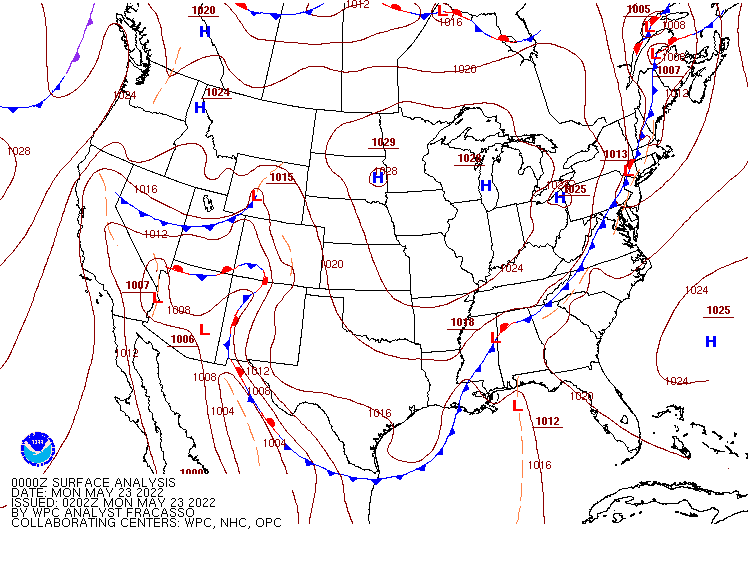
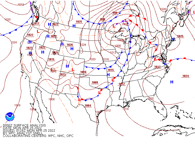
A frontal boundary extending from the Southwest to the East Coast will be the main focus for the next few days. Image provided by NOAA.
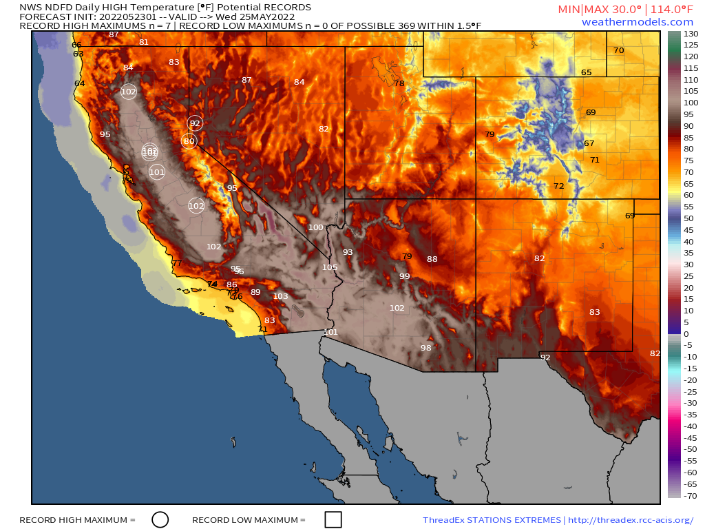
A ridge of high pressure will settle into parts of the West and Southwest by mid-week, allowing warm to hot weather to return to parts of California and the Desert Southwest. The hot weather will only last a few days, but several record highs are possible across interior California, where highs in the upper 90s and 100s are likely. Triple digit highs are also expected across the Southwest, including Phoenix, Tucson, and possibly Las Vegas as well. By the end of the week, the ridge will shift eastward, with cooler weather returning to California while heat shifts back into the Southern Plains and Texas.
Some record highs are possible across parts of California by midweek. Image provided by Weathermodels.com
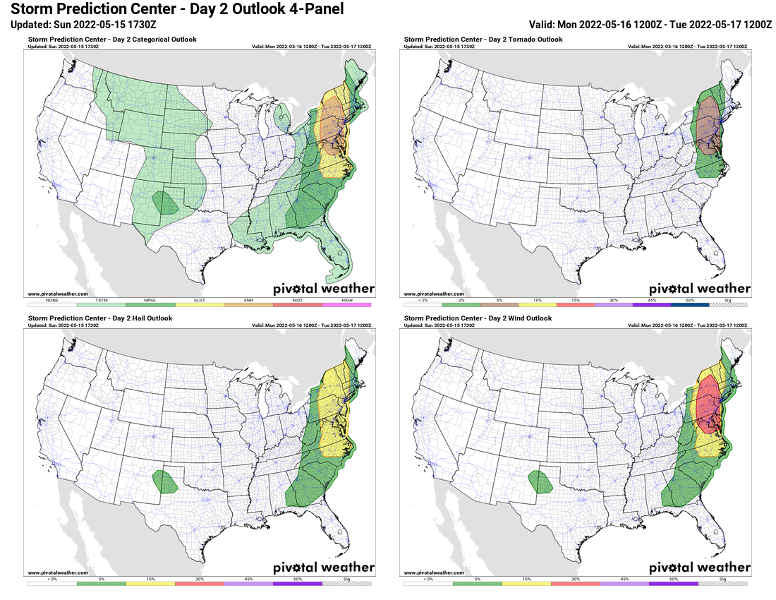
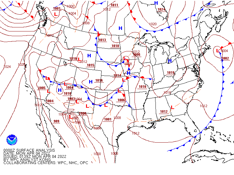
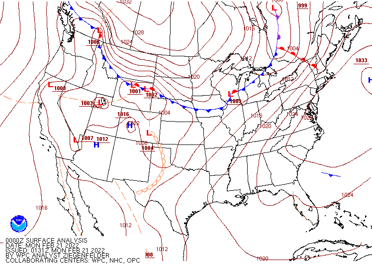
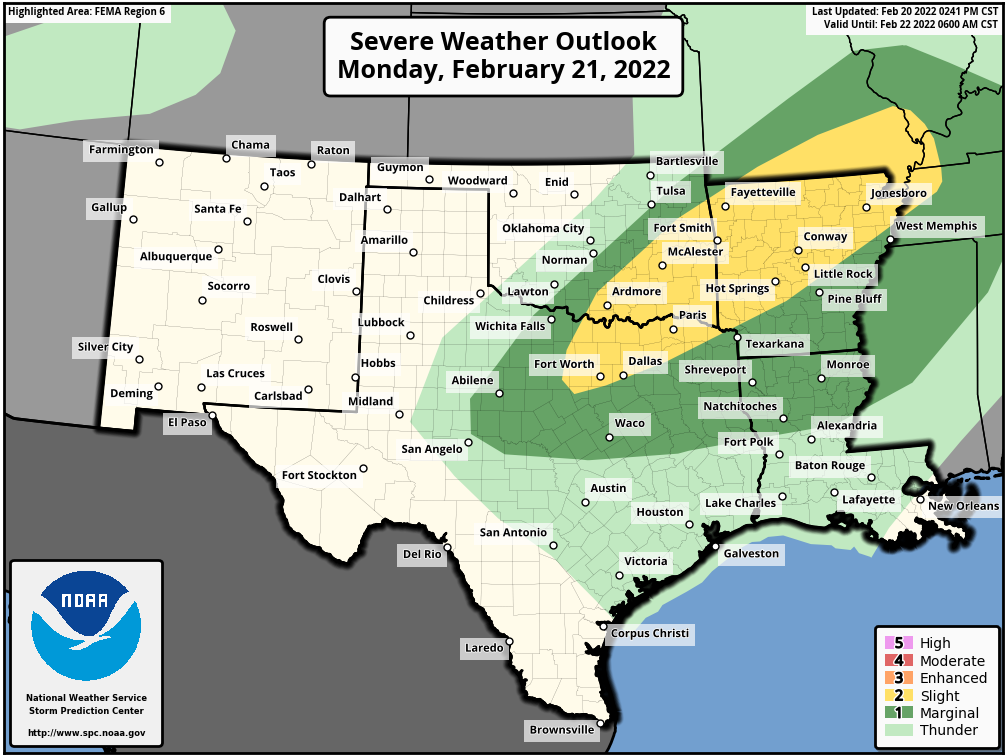
Before the heat returns to Texas, severe weather is possible across parts of the Lone Star State over the next several days. A frontal boundary will be stalled out across the region today into Tuesday, producing showers and thunderstorms, some strong to severe, across central and southern portions of the state. By mid-week, a low pressure area will develop along the front and head northeastward, spreading showers and thunderstorms into eastern parts of the state and into the Mississippi Valley.
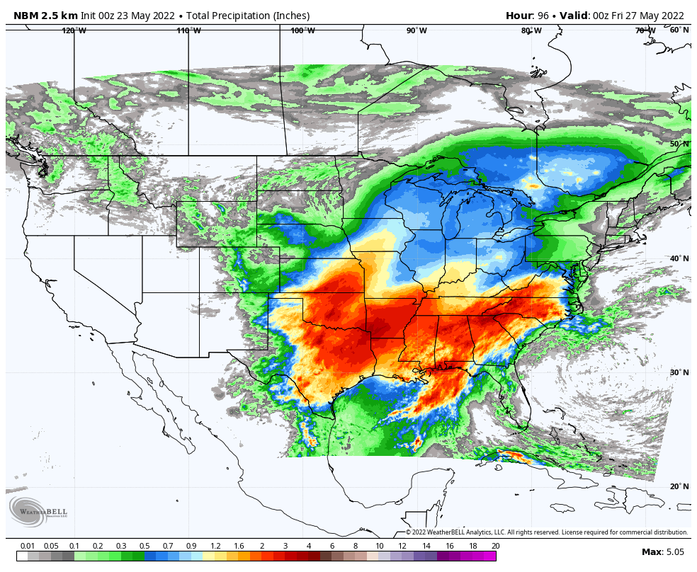
Severe weather and heavy rain are possible from Texas and the Southern Plains into the Southeast over the next several days. Image provided WeatherBell.
Severe weather isn’t the only threat with that frontal boundary. Heavy rain is likely from Texas and the Southern Plains into the Southeast over the next several days as showers and thunderstorms continue to develop and move across parts of the region. Many locations could pick up 2 to 4 inches of rain this week, with some places seeing 5 or more inches. While this will help a bit with the drought in parts of the region (notably Texas), too much rain in a short period doesn’t help, and likely will lead to flooding in many areas.
We’ve got elements of Spring, Summer, and Winter coming up across parts of the nation this week.
A frontal system stretching from Texas to the Great Lakes will impact the weather to start the week. Image provided by NOAA.
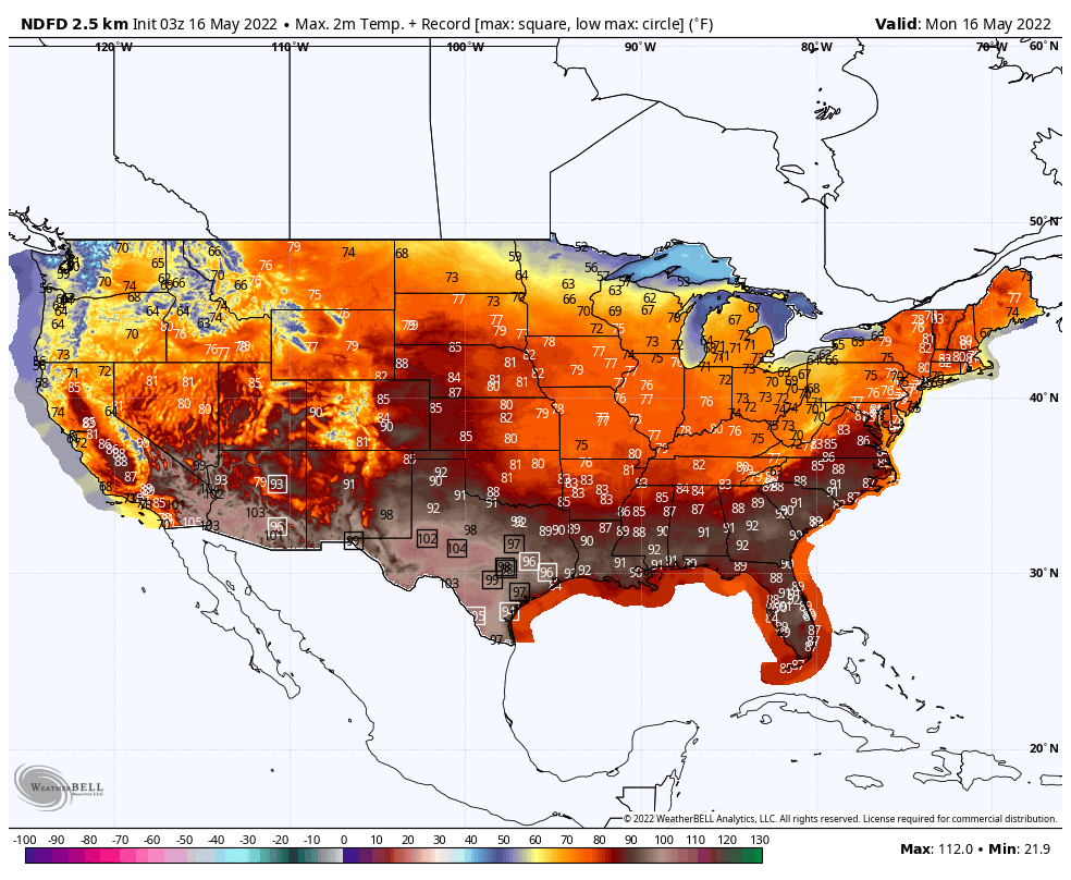
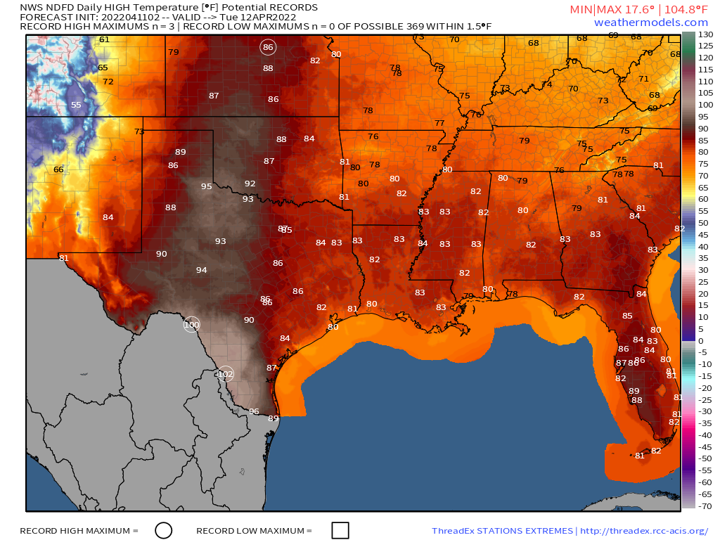
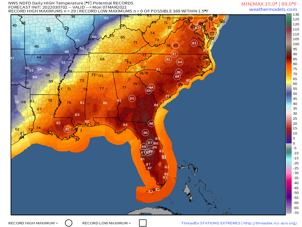
Record heat is likely from the Southern Plains into Texas over the next couple of days, spreading across the Gulf Coast and into the Southeast by midweek, then spreading up into the Mid-Atlantic states later this week and into the Northeast by the end of the week. High temperatures will be well into the 90s, with triple digits expected across portions of Texas and New Mexico, and possibly into southern Oklahoma as well. Relief may arrive across parts of the Southern Plains and Texas by the weekend, but until then mid-summer heat and humidity are expected.
Dozens of record highs are likely across the South and eventually the East this week. Images provided by WeatherBell.
Across the Northeast and Mid-Atlantic states, today will be a warm day, but not as warm as later in the week. However, a strong cold front will be approaching the region, with a severe weather outbreak expected ahead of the front. Thunderstorms will likely move across the Appalachians during the morning, reaching the I-95 corridor during the late afternoon hours, before the cold front moves offshore during the evening. Any storms that do form may produce hail, damaging winds, heavy downpours, and tornadoes, especially from the Virginia Tidewater northward into parts of eastern New York and western New England.
Severe weather is expected today from North Carolina to New England. Image provided by Pivotal Weather.
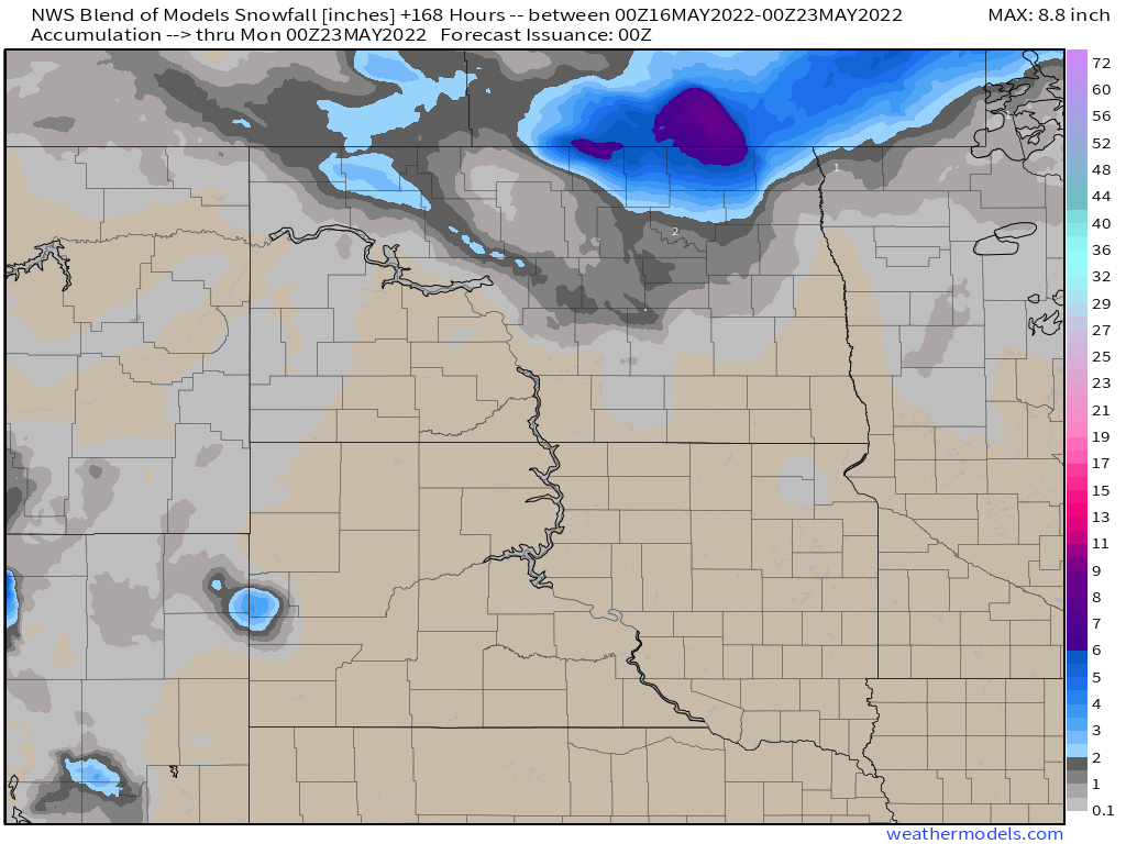
Another storm system will bring some rain and mountain snow into parts of the Pacific Northwest by midweek. While the rain won’t be exceptionally heavy, every little bit helps, as drought conditions persist, especially east of the Cascades. As that system moves eastward, it will bring rain into parts of the Northern Plains late this week. Unlike the Northwest, drought is not a problem there, but flooding is, so the rain will not be welcome. Many rivers remain above flood stage across the Dakotas, especially the Red River, so the rain, which could total an inch or more, will worsen flooding across the region. As the system passes by, colder air settles in behind it, with some snow possible in parts of North Dakota. While this is getting very late in the season for snow, it has happened before, with many locations in northern and eastern North Dakota recording measurable snow as late as the final week of May in the past.
Extreme temperatures, both hot and cold, will grab most of the attention this week.
While the surface map looks crowded to start the week, there’s not a lot of active weather out there. Image provided by NOAA.
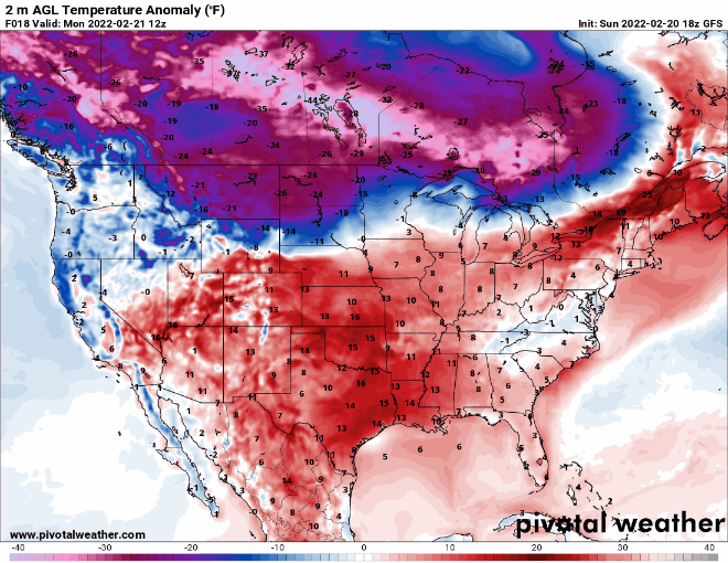
A large ridge of high pressure will dominate the eastern two thirds of the nation this week, resulting in very warm to hot weather for much of the region. High temperatures well into the 80s and 90s are likely from the Plains States into the Mississippi Valley over the next few days, with dozens of record highs likely. Triple-digit temperatures are possible across parts of Texas. As the week goes on, the heat will spread to the East Coast. By the end of the week and start of next week, temperatures in the 80s are expected as far north as parts of Quebec and Ontario.
Record highs are likely in many locations across the Plains States and Mississippi Valley this week. Images provided by WeatherBell.
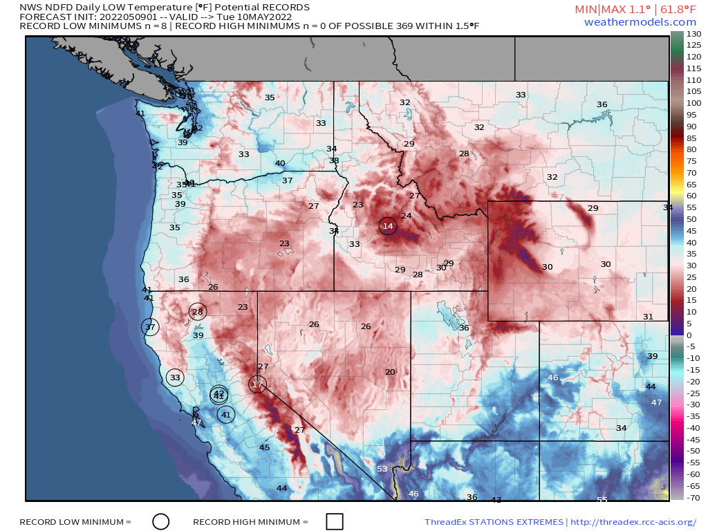
Meanwhile, much colder air will settle into the West. Temperatures will be 10-20 degrees below normal across much of the region through mid-week, with record lows possible in many locations. The chilly weather will be accompanied by rain and mountain snow from the Northwest into northern California. This is good news after a dry winter, as it will help build up the snowpack before the melt season begins in earnest.
Very chilly weather may result in record lows in several locations across the Northwest and California on Tuesday. Image provided by Weathermodels.com
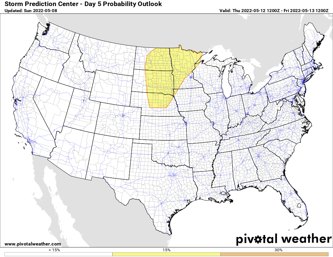
By Thursday, severe weather will be possible across parts of the Northern and Central Plains as a low pressure system moves into the region. Some of the storms that develop could produce hail, strong winds, and tornadoes. In addition, heavy rain is likely to accompany the system, which will exacerbate flooding across the region, particularly in the Red River Valley, where major flooding continues to occur.
There is a risk for severe weather on Thursday across the Northern and Central Plains. Image provided by Pivotal Weather.
The other thing we’re keeping our eyes on is the low pressure system that brought heavy rain and cool conditions to the Mid-Atlantic states over the weekend. It has moved offshore, and is expected to slowly drift southward over the next few days, milling around off the Carolina coast by mid-week. It could produce a few showers right along the coast, but for the most part, it should remain offshore. However, by later in the week, it will start to drift westward, towards the Southeast coast, spreading some rainfall toward the region. Some of the forecast models are showing the potential for it to acquire some tropical or subtropical characteristics as it does so. Sea surface temperatures are still a bit on the cool side (72-77F) for any tropical development, but in recent years we’ve seen some subtropical systems develop over the western Atlantic as we head into mid-May (whether they were actually subtropical or not is a debate we won’t get into at this time). Hurricane Season officially begins June 1 in the Atlantic.
If a tropical system were to develop in mid-May, the Caribbean or the waters north and east of the Bahamas are likely spots. Image provided by the National Hurricane Center.
April will end on a fairly quiet note across much of the nation.
A strong cold front will be the primary weather-maker for the next day or two. Image provided by NOAA.
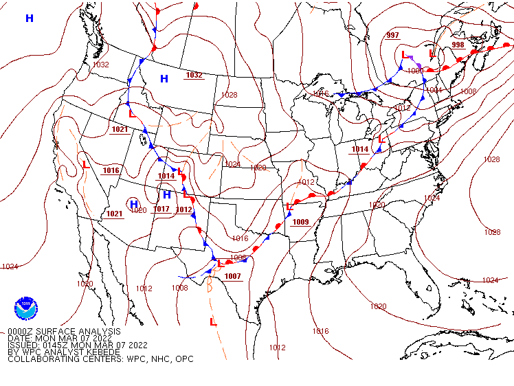
A strong cold front will move across the Eastern US over the next day or two. It may produce some strong to severe thunderstorms today from Texas to the Great Lakes, but a widespread severe weather event is not expected. Some storms may produce gusty winds, hail, heavy downpours, and possibly a tornado. As the system reaches the East Coast on Tuesday, it will produce some showers and thunderstorms, but again, severe weather is not likely.
A few severe storms are possible ahead of a cold front from the Great Lakes to Texas today. Image provided by Pivotal Weather.
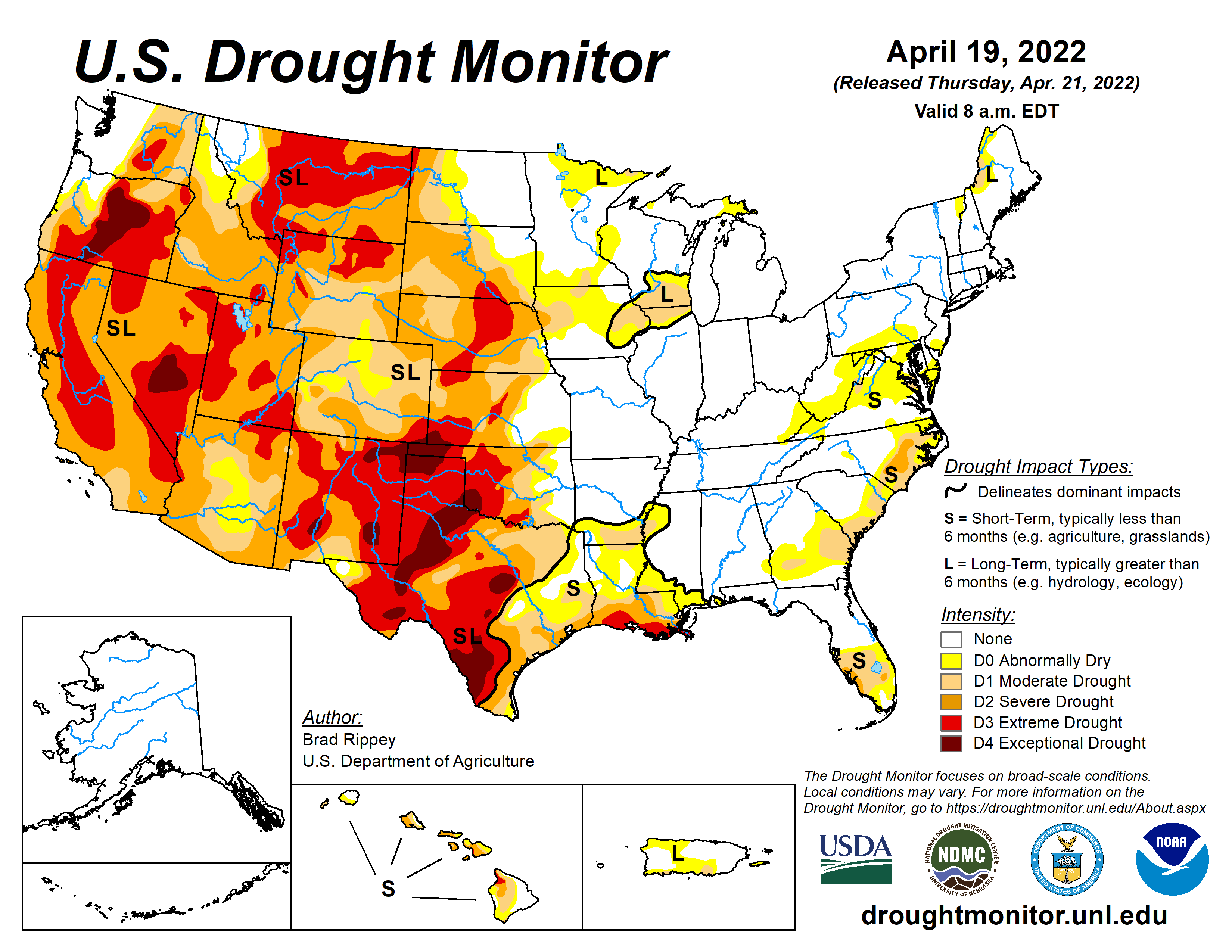
Across the West, the lack of rain will be cause for concern this week. The rainy season is nearly over, and little to no rainfall is expected this week across much of the Southwest, Great Basin, and California. A severe drought remains in progress across the region, and the lack of rainfall, combined with gusty winds later this week, will result in an increased threat for wildfires. Several large fires are already burning in parts of the region, and the dry weather will not help.
Drought conditions continue across the western half of the nation. Image provided by the National Drought Mitigation Center.
The other thing we’re watching this week is some unseasonably cool weather that will spread across the eastern two thirds of the nation. The chilly weather will continue across the Plains states today in the wake of this past weekend’s storm system. Temperatures will be 10 to 20 degrees below normal from parts of Texas to the Great Lakes today. with parts of the Dakotas and Minnesota seeing temperatures as much as 30 degrees below normal. While the chilly air will persist in the Northern Plains for the next few days, temperatures will start to moderate across the Central and Southern Plains while the chilly air slides eastward while moderating. The colder air will settle into parts of the Great Lakes and Northeast by Wednesday, and may remain in place through the weekend, though the coldest days look to be Wednesday and Thursday, when anomalies of 10-15 degrees below normal are likely across the region. A few record lows are possible each morning this week.
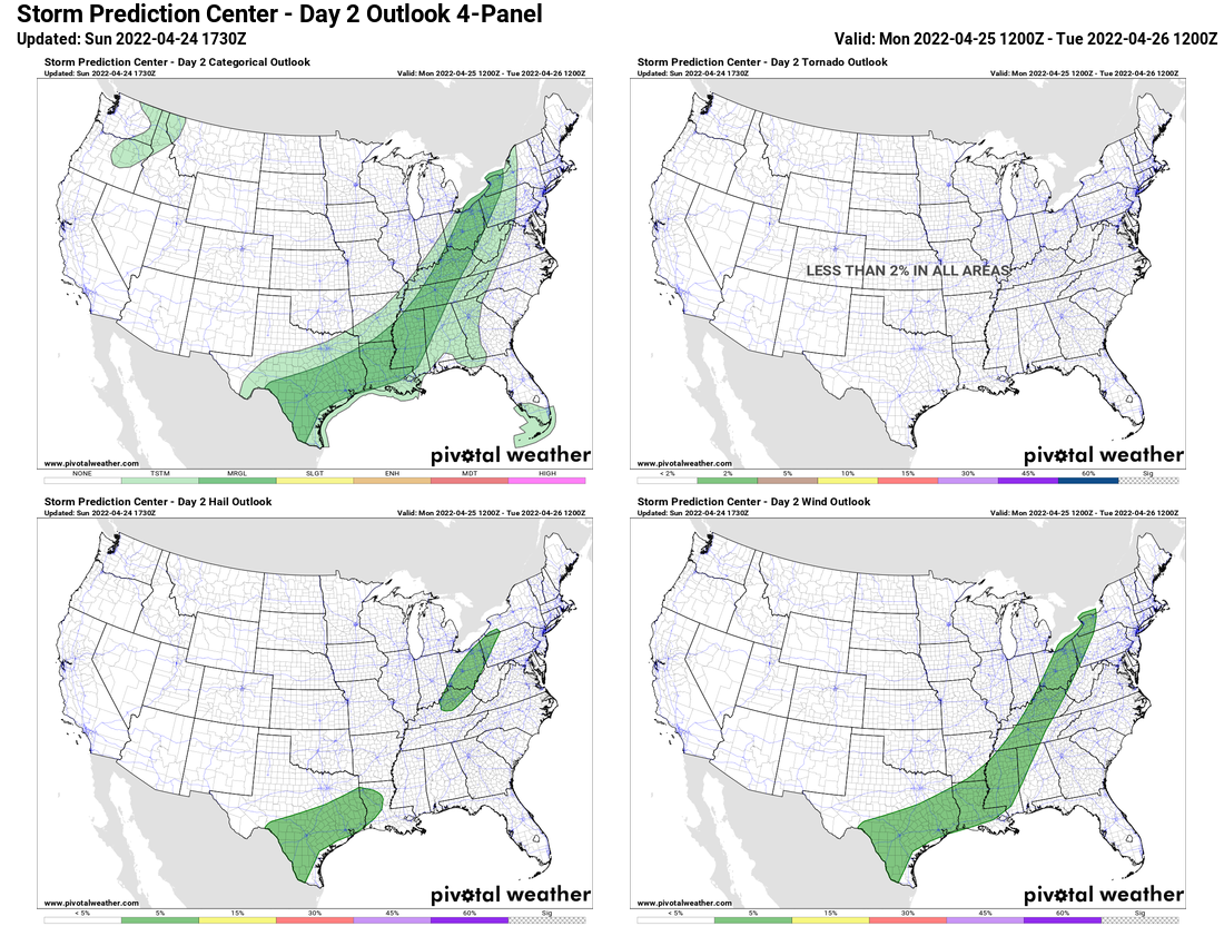
Stop us if you’ve heard this before, but we’ve got a multi-day severe weather outlook to start the upcoming week.
A couple of storm systems will impact the nation this week. Image provided by NOAA.
A low pressure system will move across the Southern Plains states today, producing showers and thunderstorms. Some of the storms may become strong to severe from parts of central Texas northeastward into the Middle Mississippi Valley. The main threat with these storms will be large hail, but some storms may also produce strong winds, heavy downpours, and tornadoes. This is just the start of what is to come.
Yet another multi-day severe weather outbreak is likely to start the week. Image provided by Pivotal Weather.
A stronger storm will develop across the central Rockies on Tuesday, heading toward the Northern Plains and Upper Midwest on Wednesday. Strong to severe thunderstorms are expected across a very large area as warm, humid air flows northward from the Gulf of Mexico ahead of the storm and much colder air settles southward from Canada behind it. That airmass may produce some record highs across southern Texas during Tuesday and Wednesday, with temperatures in the upper 90s and lower 100s across the Rio Grande Valley.
Triple-digit highs may set a few records in south Texas on Tuesday. Image provided by Weathermodels.com
On Tuesday the severe weather threat exists from eastern Texas and the eastern Plains States into much of the Mississippi Valley. By Thursday, the threat will shift eastward slightly, continuing across the Mississippi Valley, and spread into parts of the Ohio and Tennessee Valleys. Many storms will produce large hail, damaging winds, torrential downpours, and tornadoes. The threat will shift into the Southeast and Mid-Atlantic states by Thursday, but on a more limited basis.
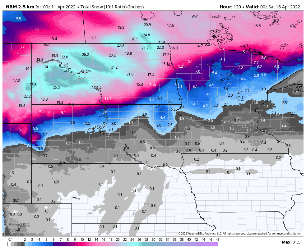
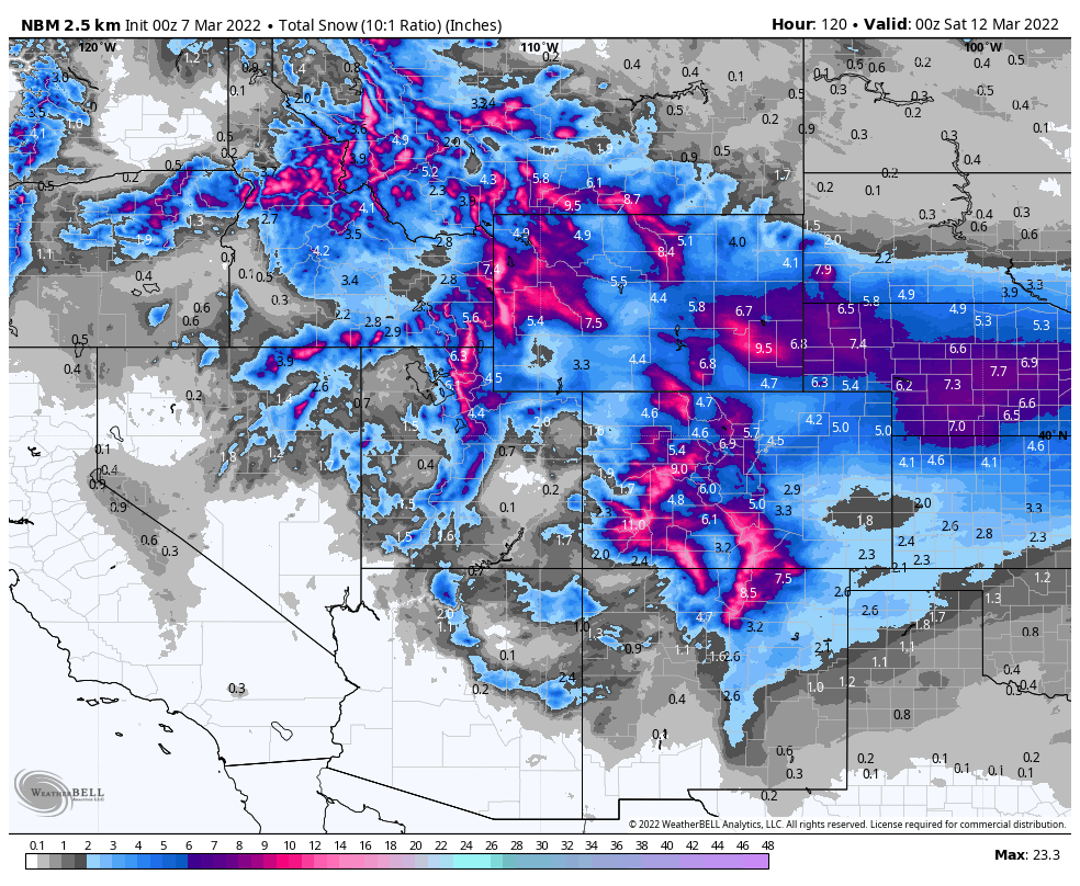
To the north, as the system moves into Northern Plains later Tuesday, snow will develop in parts of the Dakotas and Minnesota as well as south-central Canada. Snow will become heavy and winds will increase, resulting in blizzard conditions across parts of the region, The system will slow down, with snow and gusty winds continuing through the day on Wednesday and possibly into early Thursday. Snowfall totals of 1-2 feet are possible in parts of the region, but wind gusts of up to 50 mph will create significant blowing and drifting snow.
The potential exists for significant snow across the Northern Plains this week. Image provided by WeatherBell.
Behind the storm, a much colder airmass will settle into Rockies and Plains states, Temperatures will be as much as 15 to 30 degrees below normal for Wednesday and Thursday. Some record lows are possible in parts of the Northern Rockies and Northern Plains during the latter half of the week as temperatures drop into the single numbers and teens across a large area.
Heavy rain is expected across parts of the Northwest and Northern California this week. Image provided by Weathermodels.com
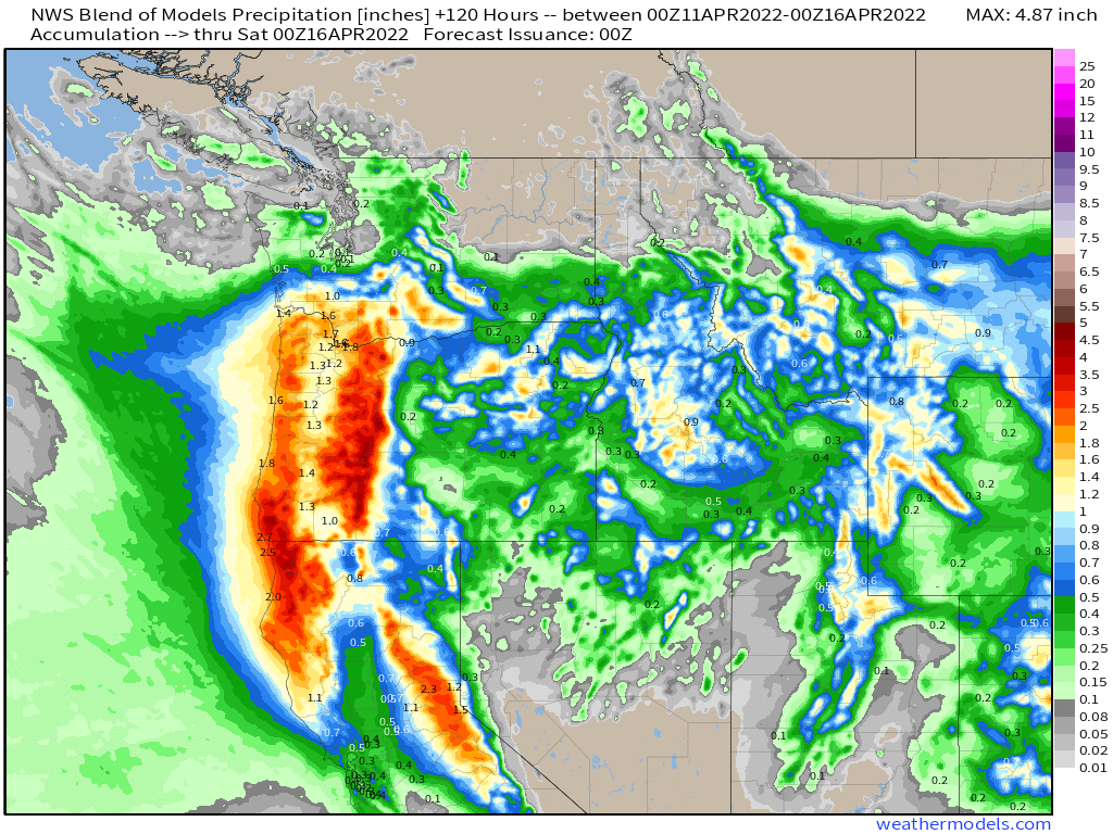
Out West, a series of low pressure systems will bring heavy rain and mountain snow to parts of the Pacific Northwest and Northern California this week. The first system moves in today and will be the strongest one, and will eventually become the system mentioned above that produces severe weather and blizzard conditions across the nation’s mid-section. A second system follows for Tuesday into early Wednesday, followed by a third one on Thursday. Rainfall totals of 1-3 inches and locally heavier are possible, especially near the coast from southern Washington into northern California. Heavy snow is likely across the Cascades and Sierra Nevada, as well as the coastal ranges. Many places could pick up anywhere from 1-3 feet of snow, with parts of the Cascades likely receiving even more than 3 feet. Across the Inland northwest, many places could see more than a foot of snow as the system pushes inland. It’s been a very dry winter for the most part across the West, so the rain and snow will be welcome news across the region as the dry season is quickly approaching.
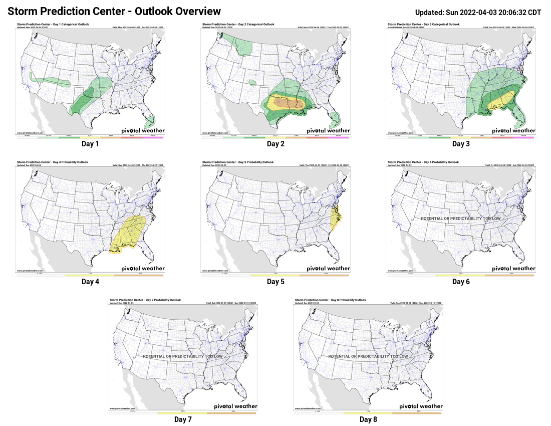
Another multi-day severe weather outbreak is expected across the southern tier of states this week thanks to a pair of storm systems.
Low pressure moving into the Southern Plains will help produce severe weather over the next few days. Image provided by NOAA.
Low pressure will move out of the Plains states and into the Mississippi Valley today. Ahead of the system, another round of strong to severe thunderstorms is expected from the southern Plains and Texas into the Lower Mississippi Valley. Many of the storms will produce large hail, damaging winds, heavy downpours and tornadoes. As the system heads eastward, the severe weather threat will shift to the Gulf Coast and the Southeast on Tuesday. While the activity may not be as strong or as widespread, severe storms are still expected across much of the region. That system will move off the East Coast late Tuesday, bringing some rain, possibly heavy, to parts of the Mid-Atlantic states and into the Northeast.
Severe weather is expected across the southern tier of states over the next several days. Image provided by Pivotal Weather.
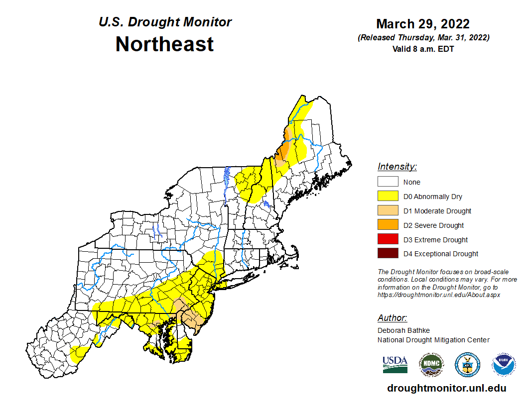
Another storm quickly follows on Wednesday, with the threat of severe weather returning to the Tennessee Valley and Deep South. Once again, some of the storms may produce damaging winds, hail, heavy downpours, and tornadoes. This threat will shift into the Mid-Atlantic states by Thursday. Another round of heavy rain is also likely from the Mid-Atlantic into the Northeast on Thursday, which could lead to some localized flooding. Parts of the region have been somewhat dry recently, with drought conditions beginning to show up in some areas, so the rain will be good news.
Drought conditions are beginning to show up across parts of the Northeast. Image provided by the National Drought Mitigation Center.
While the rain is good news for the developing drought, for some places in the Northeast, the rain will not be a welcome sight on Thursday, as it is Opening Day for Major League Baseball in 9 cities across the nation. The rain will threat to wipe out at least two of those games, when the Boston Red Sox visit the New York Yankees, and Washington Nationals host the New York Mets. At the very least, significant rain delays are possible. Rain could also cause some delays in Chicago, where the Cubs open up against the Milwaukee Brewers.
The baseball season opens a little later than normal this coming Thursday. Image provided by MLB.com
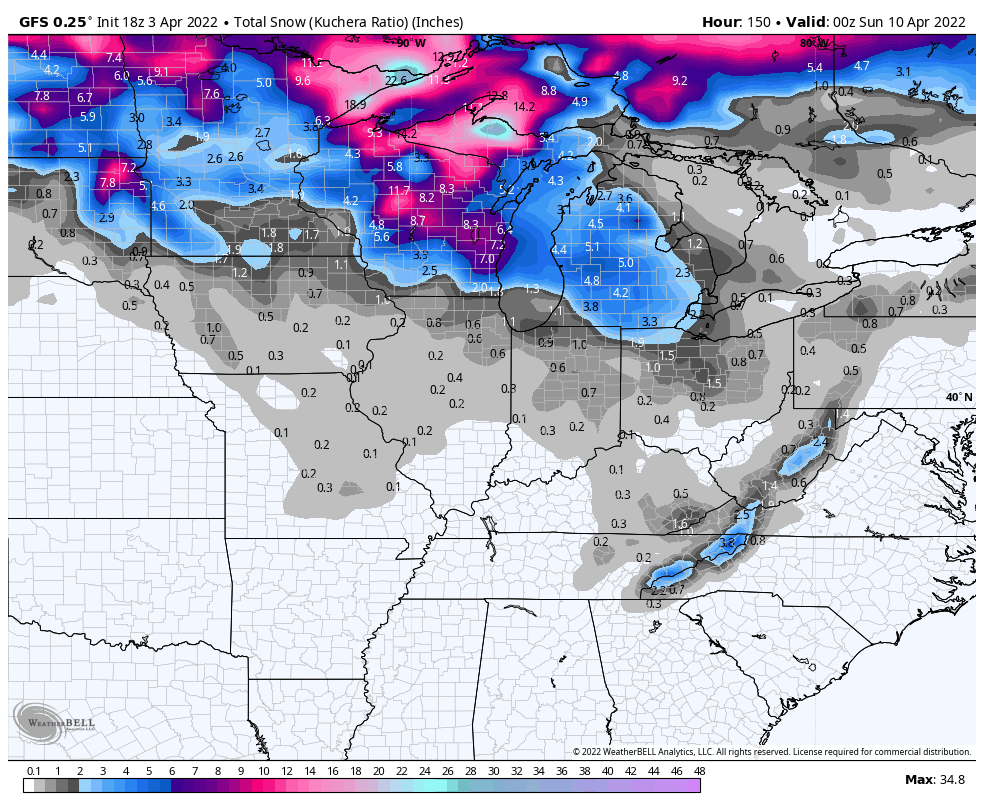
Meanwhile, in the Northern Plains and the Upper Midwest, a slow-moving storm system, both at the surface and aloft, will take its time crossing the region later this week. Some occasional rain showers are likely, eventually changing over to snow as colder air settles in. Several inches of snowfall accumulation possible from the Dakotas into the northern Great Lakes, spread out over several days, with some locations possible seeing as much as 8-12 inches of snow by the time everything winds down at the end of the week.
Accumulation snow is expected from the Dakotas into the Great Lakes this week. Image provided by WeatherBell.
Astronomical spring begins next Sunday at 11:33am, and right on cue, severe weather season will start to ramp up across the southern tier of states.
Low pressure moving into the Southern Plains will be the big story over the next few days. Image provided by NOAA.
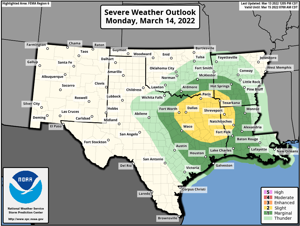
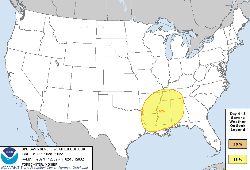
A low pressure system will move into the southern Plains and Texas on Monday, drawing warm and humid air northward from the Gulf of Mexico. This will help fuel some strong to severe thunderstorms during the afternoon and at night across portions of eastern Texas and into the Lower Mississippi Valley. Some of the stronger storms may produce large hail and damaging winds, with a few tornadoes possible, especially in parts of northeastern Texas. As the storm moves eastward. the severe weather threat will shift with it, spread into parts of the Gulf Coast and northern Florida on Tuesday, where damaging winds will be the main threat.
Severe weather is possible in parts of eastern Texas and the Lower Mississippi Valley on Monday. Image provided by the Storm Prediction Center.
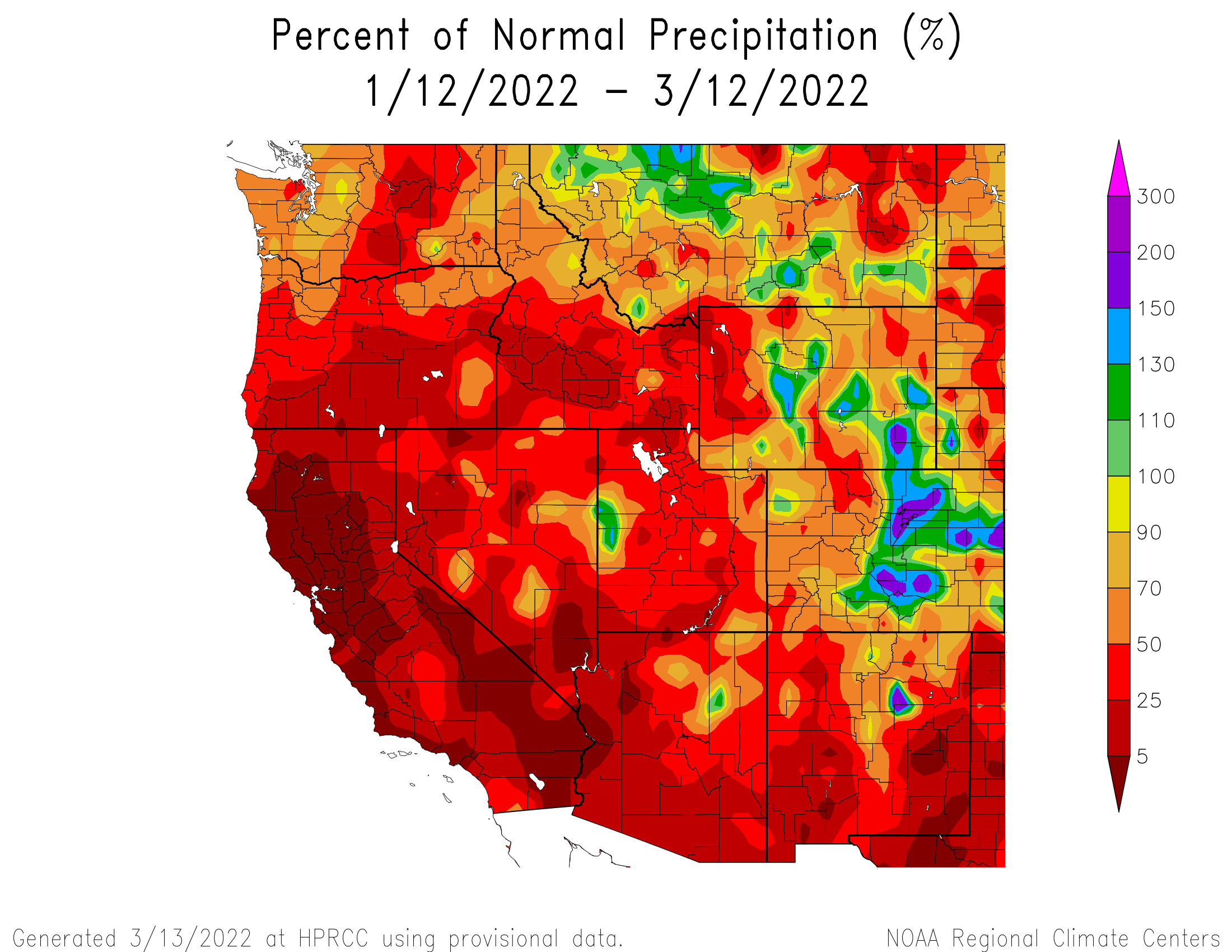
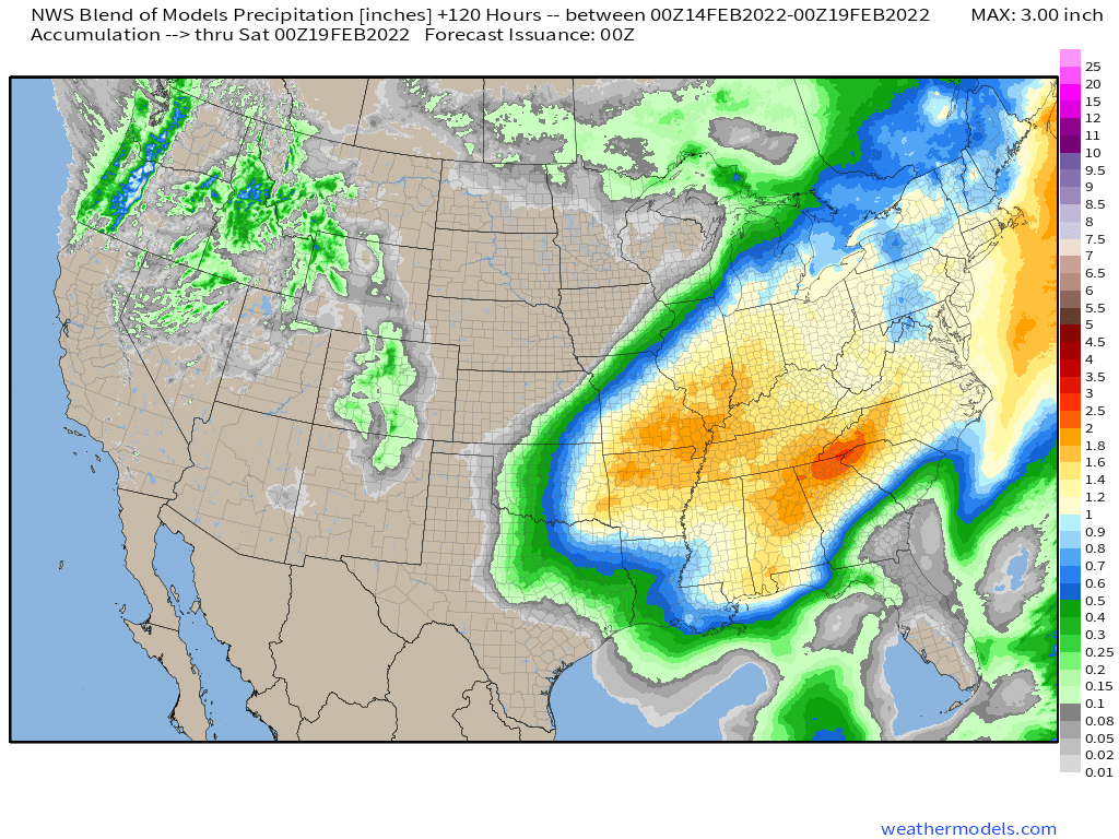
Out West, some much-needed rainfall will return later this week. After a very wet end to 2021, much drier weather has settled into the West Coast for the first 10 weeks of 2022, during what is normally the rainy season. A series of storms systems will move in this week, bringing some rain and mountain snow to parts of Washington, Oregon, and at least northern portions of California, as well as parts of Idaho and western Montana. Over the next seven days, many locations could receive 1-2 inches of rain, with significantly heavier amounts possible west of the Cascades and along the coast. Significant snow is possible in the mountains, especially the Cascades. None of these systems are expected to produce exceptionally strong winds, except perhaps right at the coastline.
Rainfall has been well below normal across most of the West over the past 60 days. Image provided by the High Plains Regional Climate Center.
The other area we’re keeping an eye on stretches from the Northern Plains into the Northeast. Temperatures will be quite mild for much of the upcoming week. Temperatures will be 10 to 20 degrees above normal across much of the region through at least Thursday in the Plains, and Friday across the Great Lakes and Northeast. A few record highs are possible, especially toward the end of the week across the Northeast.
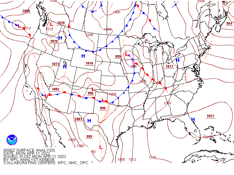
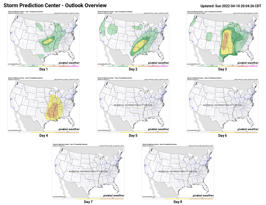
A rather active week is expected, especially across the eastern two-thirds of the nation.
A wavy frontal system is draped across the nation to start the week. Image provided by NOAA.
Low pressure will move across the Ohio Valley and into the Northeast today, providing a variety of weather for the eastern half of the nation. The most impactful weather will be strong to severe thunderstorms, especially from the Deep South across the Tennessee Valley and into the Appalachians. Some of the storms may produce damaging winds, heavy downpours, and possibly tornadoes. In addition to the severe weather, heavy rain is expected across the Ohio Valley. Widespread rainfall totals of 1-2 inches and locally heavier are expected, resulting in Flood Watches being issued for much of the region.
Severe weather is possible today from the Tennessee Valley into the Appalachians. Image provided by the Storm Prediction Center,
Ahead of the storm, unseasonably warm weather will remain in place today from the Gulf Coast into the Mid-Atlantic states and parts of the Northeast. High temperatures should reach 80 or higher from Washington, D.C. southward, with 70s into the Mid-Atlantic states. Dozens of record highs are expected to be set once again.
Dozens of record highs are likely across the East and South today. Image provided by Weathermodels.com.
Later this week, another low pressure system is expected to develop across the West. It will bring a snowstorm to parts of the Rocky Mountains and into the Plains states. Snowfall totals of 4-8 inches will be widespread, with many locations, especially at the higher elevations, possibly seeing more than a foot. Snowfall has been below normal across the region this year, and parts of the region rely on the snowmelt for water in the spring/summer, so any snow that falls now is welcome.
Moderate to heavy snow may fall across the Rockies later this weekend. Image provided by WeatherBell.
Once it moves away from the Rockies, that system could become a rather potent storm system as it heads eastward. Ahead of the system, heavy rain and possibly more severe weather may impact parts of the Gulf Coast, Deep South, and Southeast towards the end of the week and into the weekend, with heavy snow possible north and west of the system from the Plains states into the Great Lakes and parts of the Northeast. There are some indications that it could become rather strong as it moves into the Northeast, with the potential for strong winds across much of the East Coast. This will be something to keep an eye on later this week.
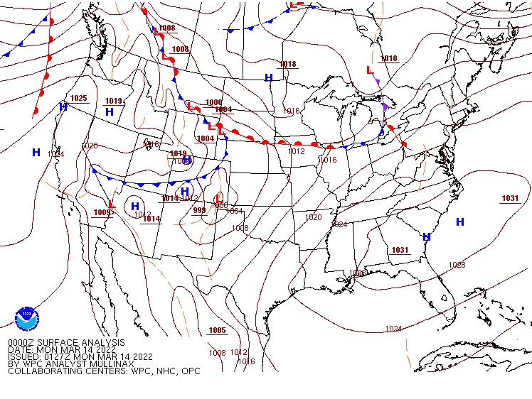
A rather active pattern is expected across the nation during the upcoming week.
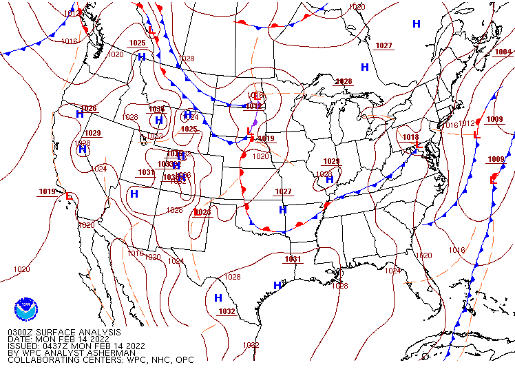
The surface analysis doesn’t look busy to start the week, but the pattern will be quite active. Image provided by NOAA.
Low pressure will move into the southern Plains today, heading toward the Great Lakes on Tuesday, then up the St. Lawrence Valley Tuesday night, producing a variety of weather across the eastern two thirds of the nation. As it draws warm and humid air northward from the Gulf of Mexico, it will produce some heavy rain and thunderstorms, some of which could be strong to severe, across parts of southern Plains and Mississippi Valley today and tonight, with the heavy rain and severe weather threat shifting into Deep South and Tennessee Valley on Tuesday. Many areas could see 1-2 inches of rain, with heavier amounts possible, which could lead to flooding in some areas. Unseasonably mild weather is also likely ahead of the storm, with some record highs possible in the Mississippi Valley on Tuesday and parts of the Southeast on Wednesday. A few record highs are also possible in the Northeast during Tuesday and Wednesday and warmer air surges northward ahead of the system.
Severe weather is possible from the Southern Plains into the Mississippi Valley on Monday. Image provided by the Storm Prediction Center
To the north, the storm will produce heavy snow and gusty winds, resulting in near-blizzard conditions at times from the Northern Plains into the Great Lakes over the next couple of days. Snowfall totals of 5-10 inches are possible in parts of the Dakotas today into Tuesday, but in the Great Lakes, many areas could see a foot or more. Once the snow ends, arctic air will settle into the region. Temperatures will drop below zero each night this week across most of the Northern and Central Plains and the Upper Midwest, with record lows possible in many locations. Temperatures will be 20 to 40 degrees below normal through Wednesday before some moderation begins.
Very cold air settles into the Plains States and Midwest over the next several days while warm air moves into parts of the East and South. Loop provided by Pivotal Weather.
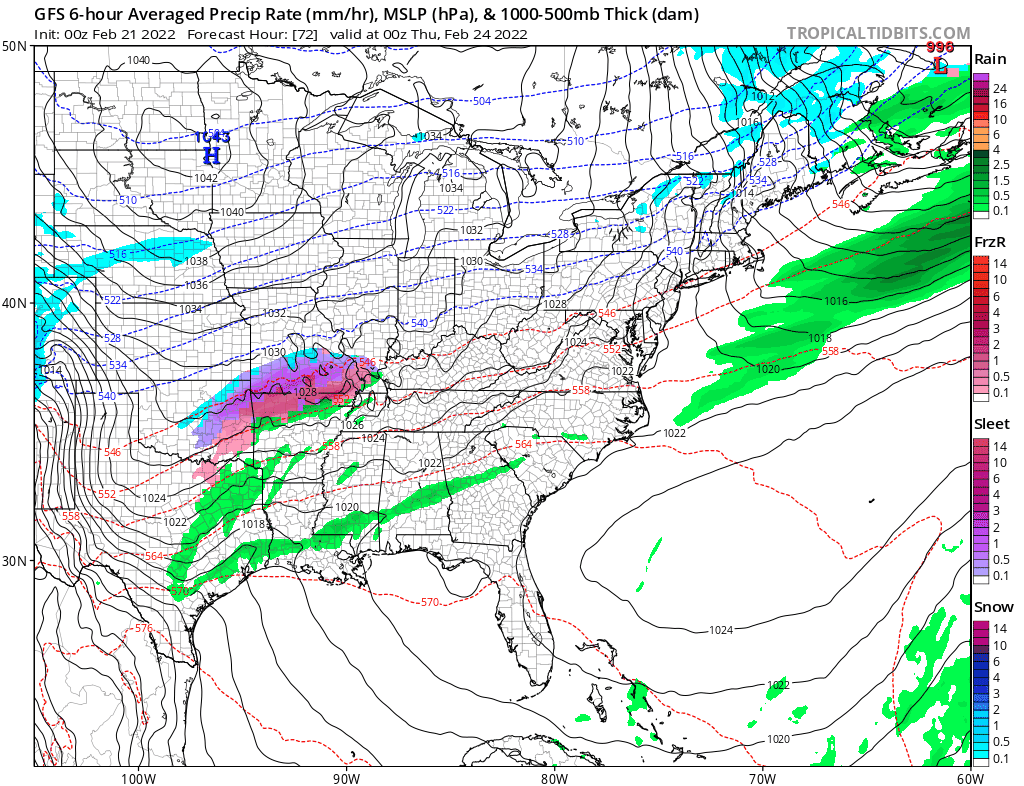
Later in the week, we’ll do it all over again. Low pressure will move out of the Southern Plains and toward the Ohio Valley on Thursday, before redeveloping off the Mid-Atlantic coastline. Ahead of the storm, some heavy rain and thunderstorms are likely from the Lower Mississippi Valley into the Deep South and the Mid-Atlantic states, with more record highs possible across parts of the Southeast. The difference this time is with a track farther to the south compared to the early-week storm, the threat for wintry weather will increase from the Ohio Valley into the Northeast. The exact track will determine what areas get all snow and what areas see a mix of snow, sleet, and/or freezing rain, but areas that remain all snow have the potential for 6 or more inches of accumulation.
Another storm will bring a variety of weather to the eastern half of the nation later this week. Loop provided by Tropical Tidbits.
While the pattern will remain quiet for much of the nation to start the week, a significant storm may impact a large portion of the nation later this week with a variety of weather.
A wavy frontal system extends across much of the nation to start the week. Image provided by NOAA.
A low pressure system will bring some rain and higher elevation snow to parts of the Pacific Northwest and the Great Basin over the next day or two, but its biggest impacts will be felt later this week. as it moves into the nation’s mid-section on Wednesday, it will start to draw warm and humid air northward from the Gulf of Mexico. At the same time, a large high pressure area will bring colder air into the Northern Plains. As these airmasses clash, we could see some strong to severe thunderstorms developing ahead of the system. Severe storms are possible across parts of the Southern Plains and Texas late Wednesday, with the severe weather threat shifting into the Mississippi and Tennessee Valleys on Thursday, reaching the Deep South and the Southeast by Thursday night.
Severe weather is possible across parts of the Mississippi Valley and Deep South on Thursday. Image provided by the Storm Prediction Center.
To the north of the storm, a narrow strip of heavy snow is possible from eastern Kansas into the Great Lakes, possibly including the Chicago area. Many locations in this region could see 6 or more inches of snow from storm. Ahead of the storm, heavy rain is likely across the eastern half of the nation during Thursday and Friday. Rainfall totals of 1-2 inches and locally heavier are likely from the Mississippi Valley to the East Coast, with some heavier amounts possible.
Heavy rain is possible across a large portion of the nation later this week. Image provided by Weathermodels.com
In addition to the heavy precipitation, unseasonably warm air is expected ahead of the storm. Temperatures will be 10-20 degrees above normal on Wednesday from the Southern Plains into the Ohio Valley. By Thursday, the warm air shifts to the East Coast, with temperatures likely to be 15-25 degrees above normal from the Southeast and the Ohio Valley into New England, where a few record highs are possible.
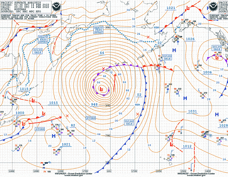
A powerful storm system is moving across the Central Pacific Ocean, heading toward Alaska. Image provided by the Ocean Prediction Center.
Meanwhile, up in Alaska, bitterly cold air remains locked in place across the northern half of the state. Temperatures will be 15-30 degrees below normal over the next couple of days. Wind Chill Warnings are in effect along the North Slope and the Arctic Coast, where wind chills of 40-70 below zero are possible today and Tuesday. However, changes are coming. A powerful Pacific storm will approach the state, and although it won’t be as strong as it currently is, it’s main impact will be to dislodge the cold air, and result in a significant temperature rise across the state. By the end of the week, temperatures could be 5-10 degrees or more above normal across a large portion of Alaska.
A significant moderation in temperature is expected across Alaska this week. Loop provided by WeatherBell.