As we head into the end of August, some familiar things start to happen. Children will start to head back to school. Baseball’s pennant races heat up while football at all levels gets ready for the start of the season. Halloween candy starts to appear in stores and it will be followed shortly by pumpkin-flavored everything. In terms of the weather, familiar things happen there too. The tropics start getting more active and the cold fronts dropping southward from Canada pack a little more punch than they usually do during the summer.
One of those cold fronts will be moving across the Plains states and into the Midwest over the next few days. Ahead of the front, summertime heat and humidity remains in place, with temperatures well into the 80s and 90s common. Behind the front is much cooler and drier air. By Friday morning, temperatures will be 10-20 degrees below normal across much of the Plains states and Rocky Mountains as a large area of high pressure builds in from Canada. Low temperatures will drop into the 40s and 50s across the Northern Plains, with 30s and even some upper 20s from the Rocky Mountains into interior portions of the Pacific Northwest.
As that cooler air settles into the region, some snow is possible across the higher elevations of the Northern and Central Rockies. Snow levels will remain fairly high, but a few inches of snow may accumulate on top of some of the higher peaks in Wyoming and Colorado.
Ahead of the front, a warm and humid airmass will remain in place, with high temperatures well into the 80s and 90s for the next few days. As the front approaches, it will trigger showers and thunderstorms. Some of the storms could be strong to severe, with hail and gusty winds possible, along with a few tornadoes. The biggest threat looks to be heavy rain and flash flooding. Because the front will be moving fairly slowly, some of the heavier storms will linger over the same areas. Rainfall totals of 1-3 inches will be common across parts of the Eastern Plains and Mississippi Valley, with some heavier amounts possible. This will likely lead to flooding in some areas.

Meanwhile, in the Atlantic, we’re keeping an eye on a disturbance east of the Lesser Antilles and Tropical Storm Gaston out in the Central Atlantic. There was a third system, Tropical Depression Fiona, but it fizzled southeast of Bermuda earlier today.
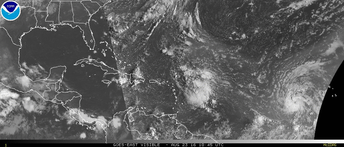
Tropical Storm Gaston is centered about 700 miles west of the Cape Verde Islands this afternoon, heading towards the west-northwest at 21 mph. Maximum sustained winds are near 65 mph, and additional strengthening is expected. Gaston should become a hurricane by Wednesday afternoon. The forecast for Gaston is to turn more towards the northwest, heading out in the Central Atlantic Ocean before starting to weaken in a few days. Gaston will likely bot be a threat to any land areas.
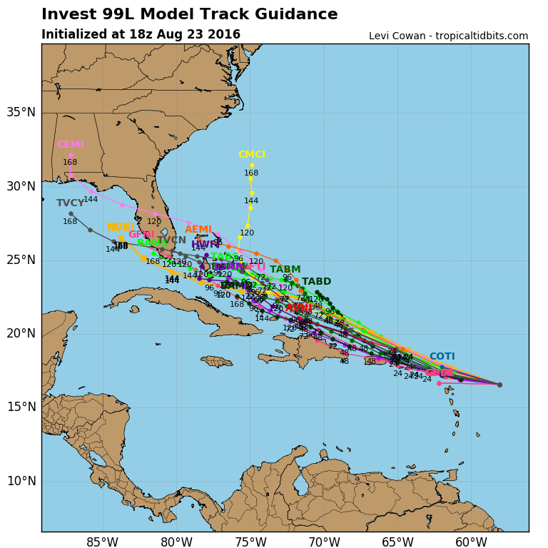
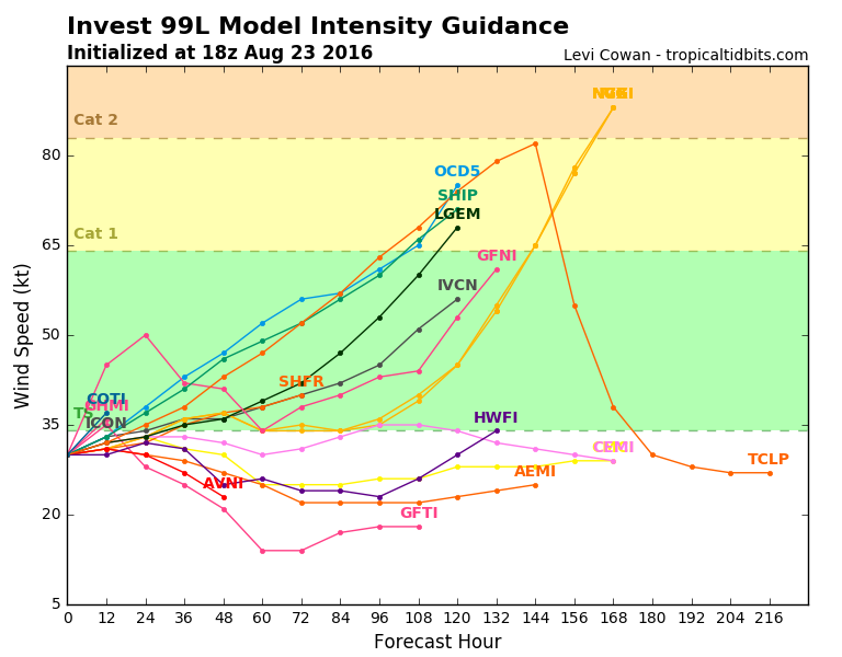
Meanwhile, a disturbance located a few hundred miles east of the Lesser Antilles is being carefully monitored for signs of development. United States Air Force Reserve Hurricane Hunter aircraft investigated the system earlier today and found it to be a weak system with an ill-defined center. Conditions are still somewhat favorable for further development, and anyone with interests in the northeastern Caribbean should continue to monitor the progress of this system. The future of this system is still a big question mark. Most of the forecast models bring the system towards the Bahamas over the next several days, though a few have the system dissipate completely before then. Once it gets to the Bahamas, there is considerable spread among the models as to where it will go, assuming it even survives that long. Some have it turn northward and head towards the Carolinas or Georgia. Some bring it into Florida, then up into the Southeast, and others bring it across Florida and into the Gulf of Mexico. As for how strong it could be, that’s an even bigger question mark. As mentioned previously, some of the models have it dissipate completely. There are other models that keep the system as a tropical depression or weak tropical storm into the Bahamas. There are others that have it as strong as a Category 2 hurricane. Once the storm actually forms (assuming it actually does), the computer models should start to get a better handle on its future.