A developing storm system will bring heavy snow to parts of the Southeast and New England this weekend, while the West Coast braces for a lot of much-needed rainfall.
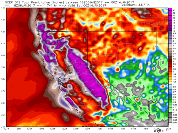
We’ll start on the West Coast, where a series of storm systems will bring plenty of rain to drought-stricken California. While this will not alleviate the drought that has been ongoing for years, it will help to put a big dent into it. The first of the storm systems will move in tonight, and by the time the last one moves through next Friday, rainfall totals of 5-10 inches will be widespread across much of central and Northern California, with many locations, especially along the coast and western slopes of mountains receiving 10-20 inches or more.
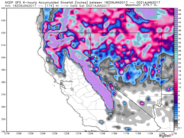
At the higher elevations, especially in the Sierra Nevada, incredible amounts of snow are expected. The snowpack, which much of the region depends on for water in the summer as it melts, is already above normal, and over the next week, some locations might see 6-12 FEET of new snow from these storm systems.
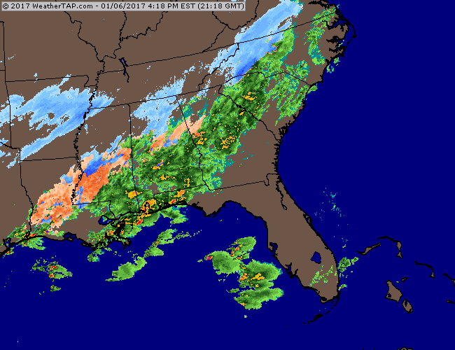
Back in the East, a storm system is riding along a stalled out front across the Southeast, producing some snow across parts of the Tennessee Valley and the Southeast. As this system draws in moisture from the Gulf of Mexico and the Atlantic, and runs into an arctic airmass already settling into the region, it will produce heavy snow in places that normally don’t see a lot of snow, such as Georgia, the Carolinas, and the Virginia Tidewater area. In these places, even a dusting of snow can cause traffic nightmares, so heavy snow can bring these areas to a standstill.

The heaviest snow from this system is expected across the Appalachians and also across the Virginia Tidewater area, as the storm gathers strength while moving into the Atlantic. Of course, the 6-12 inches expected across much of North Carolina will cause its own problems, but luckily, the bulk of the snow will fall tonight and Saturday, minimizing the travel problems. The heaviest snow should remain just south and east of the big cities of Washington, Philadelphia, and New York, but a few inches may fall in each location.
Once this storm moves off the Mid-Atlantic coast it will head northeastward, passing a couple of hundred miles south and east of Cape Cod. Normally, this would mean just a little bit of light snow for parts of Southern New England, and for the most part, that’s what we’re expecting. However, for southeastern New England, mainly south and east of I-95, it’ll be a different story from Saturday afternoon into Sunday morning.
There are a couple of factors that will enhance snowfall totals across this region. First, with northeasterly winds blowing off the Atlantic, we’ll get some ocean-effect snowfall. This is similar to the lake-effect snow that you often see near the Great Lakes. Second, temperatures will only be in the upper teens to middle 20s. This means that it will be more of a fluffy snow, which will pile up quicker than a much wetter snow.
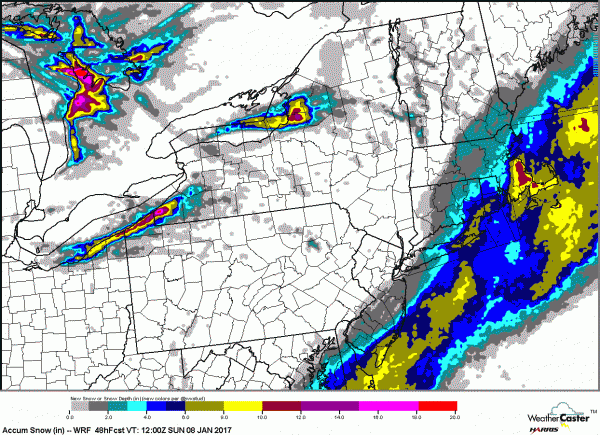
The snow should start to develop across Cape Cod and southeastern Massachusetts Saturday morning, and will quickly spread inland. The snow should spread as far inland as central Massachusetts and southern New Hampshire, but it will quickly retreat eastward again, ending in most places during the evening. The exception is Cape Cod and coastal Massachusetts, where northerly winds behind the storm may keep the ocean-effect snow going into the early hours of Sunday morning.
For snowfall totals, we’re not expecting more than an inch or two from southern New Hampshire into Central Massachusetts. Points north and west of Boston and Providence, including the Merrimack Valley, will likely see 2-4 inches, with some heavier amounts across Cape Ann. Along and south of Interstate 95, including the southern and eastern suburbs of Providence and Boston, totals of 6-12 inches seem likely, with the best chance for more than a foot of snow across parts of Plymouth County and Cape Cod, where the ocean enhancement will play a big role.
Behind the system, with fresh snow cover, temperatures will turn colder. Monday morning, temperatures will be in the single numbers across much of the region, with some sub-zero readings likely. The next storm moves in later on Tuesday, and although it will start as some snow or a wintry mix, milder air will move in, with the bulk of the precipitation falling in the form of rain Tuesday night into Wednesday.