Winters in the Northeast can be often feel long and cold, leaving residents of the region longing for sunny, warm days in the Spring and Summer. This year, they got quite a lot of them, which didn’t draw too many complaints. However, because it was so sunny and warm, much of the region is now in the midst of a very serious drought.
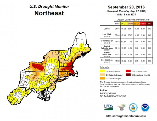
A persistent ridge of high pressure kept the Northeast dry and warm through much of the Spring and Summer. Most of the cold fronts that tried to move through the region were starved for moisture, thus their main effects were to cool temperatures and lower humidity for a day or two. Thunderstorm activity was common, but aside from localized downpours, there really hasn’t been a widespread heavy rain event across much of the region for several months. That could be changing this week.
A slow-moving cold front will move across the region on Tuesday, bringing showers with it. While the rain likely won’t be too heavy, it should be widespread, which is good news for an area that needs all the rain it can get. The front will likely stall out right along the coastal plain, which may keep the shower activity going into Wednesday right along the coast. However, changes in the weather pattern are coming that promise to bring even more rain to the area.
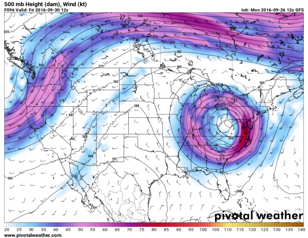
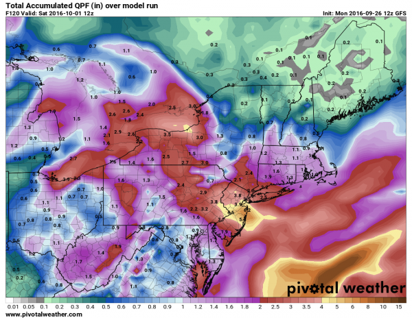
An upper-level low pressure system will drop southward from the Great Lakes and take up residence across portions of the Ohio Valley and Appalachians. It will likely stay there for several days, before lifting out to the northeast this weekend. However, with the upper-level low pressure area just sitting there, low pressure will essentially remain in place at the surface as well across the same area. This will result in periods of rain and showers across much of the area right through the week. While the rain may be briefly heavy at times, persistent rainfall over several days can add up, with some areas possibly receiving 1-3 inches of rain between Tuesday and Friday, with some heavier amounts possible. Rainfall deficits in this area are on the order of 5-10 inches, so much more is needed, but this is definitely a good start.
Of course, this beneficial rain may not impact the entire Northeast. For New England, the forecast is much trickier. With the low setting up well to the southwest of the area, high pressure will try to build in from the north. This will bring cool and dry conditions into much of northern New England this week. As for southern New England, where the effects of the drought are the most pronounced, the forecast depends entirely on where the low and high set themselves up. If the high is the dominant feature, much of southern New England can expect dry and cool conditions, with gusty east to northeasterly winds bringing some clouds and drizzle in off the Atlantic at times. If the low sets up a bit closer to the region, then the forecast will trend more towards a damp scenario with periods of showers for the next several days. At this point, it’s still a little too early to tell which scenario will be the correct one.